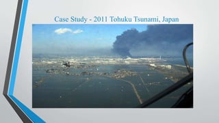
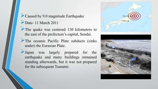
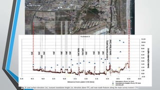
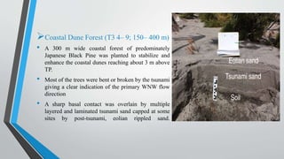
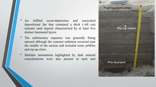
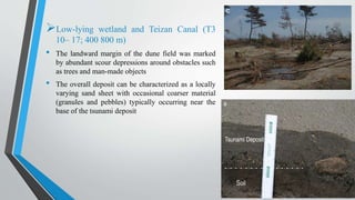
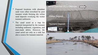
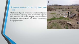
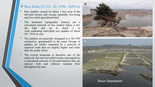
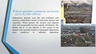
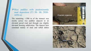
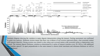
TSUNAMI
Presented by
SAURAV SHEKHAR
ENTRY NO 2014CEU2921
Case Study - 2011 Tohuku Tsunami, Japan
Caused by 9.0 magnitude Earthquake
Date- 11 March 2011
The quake was centered 130 kilometers to
the east of the prefecture’s capital, Sendai.
The oceanic Pacific Plate subducts (sinks
under) the Eurasian Plate.
Japan was largely prepared for the
earthquake and many buildings remained
standing afterwards, but it was not prepared
for the subsequent Tsunami.
Contd.
200000 people killed
500km2 coastal plains hit, destroying farmland, settlements and
communications.
Ruptured gas pipes led to fires.
Explosions at the Fukushima nuclear power plant- this led to nuclear
contamination and the possibility of meltdown as the cooling systems failed.
Electricity lost in 6 million homes, 1 million had no running water.
PAPER-Erosion, deposition and landscape change on the Sendai
coastal plain, Japan
INTRODUCTION
 Case studies of recent tsunami impacts have proven to be extremely useful in understanding the
geologic processes involved during inundation and return flow, and refining the criteria used to
identify paleotsunami deposits in the geologic record.
 Field observations focused on measurements of tsunami flow characteristics (height and
direction), mapping of erosion features and assessing sediment deposition based on shallow
trenches at 50–100 m spacing.
 In this paper the survey results for the surficial deposits, flow heights and directions, and
landscape change with an emphasis on erosion and deposition along a 4.5 km shore-perpendicular
transect based on field observations and measurements were described. This study documents the
geologic characteristics of the 2011 Tohoku-oki tsunami on the Sendai coast, and provide a
background for related studies including sedimentology, geochemistry, micropaleontology,
mineralogy and modeling that are reported in this special issue.
METHOD
A shore-normal transect line (T3) was established along the Sendai coastal plain just north of
Sendai Airport with measurement locations at 50 m intervals from the shoreline to 4500 m
inland.
The tsunami deposits were described and sampled at 50–100 m intervals along with
observations of erosion and landscape change. At many localities the deposit thickness was
measured at the center line and at 5 and 10 m spacing away from the center to document
local variability.
Tsunami inundation heights (elevation above Tokyo Peil, TP, which corresponds to the mean
sea level determined in Tokyo Bay) and topographic profiles were measured using high
resolution survey equipment (Promark 3, Ashtech), hand-held laser rangefinders and GPS
units.
One of the advantages of studying a transect adjacent to Sendai Airport was the
comprehensive video coverage of the area taken during inundation, thus allowing
comparison of local flow variations with deposit characteristics and landscape changes.
RESULTS: TRANSECT MORPHOLOGY AND
OBSERVATIONS
Beach face and back beach (T3 1– 4; 0– 150
m)
• The active beach was composed of
unconsolidated sand with little or no
vegetation in a ~ 150 m wide zone. The beach
face slope at the time of the survey was 12
degrees. This was the site of extensive erosion
during the passage of the tsunami wave(s) and
the source area for much of the sand deposited
further inland.
• Flow acceleration in the lee of the dune ridge
is the probable erosional mechanism forming
the elongate depression.
• Funnel shaped incisions in the
beach face, with the widest
portion facing seaward, were
partially infilled at the time of
our survey.
• The tsunami eroded into the
poorly-developed soil and sparse
back beach vegetation, which
was preserved between the
incisions.
Coastal Dune Forest (T3 4– 9; 150– 400 m)
• A 300 m wide coastal forest of predominately
Japanese Black Pine was planted to stabilize and
enhance the coastal dunes reaching about 3 m above
TP.
• Most of the trees were bent or broken by the tsunami
giving a clear indication of the primary WNW flow
direction
• A sharp basal contact was overlain by multiple
layered and laminated tsunami sand capped at some
sites by post-tsunami, eolian rippled sand.
• An infilled scour-depression and associated
depositional fan that contained a thick (~60 cm)
tsunami sand deposit characterized by at least five
distinct laminated layers
• The sedimentary sequence was generally fining
upward although the coarsest sediment occurred near
the middle of the section and included some pebbles
and rip-up clasts .
• Multiple laminations highlighted by dark mineral
concentrations were also present in each unit
Low-lying wetland and Teizan Canal (T3
10– 17; 400 800 m)
• The landward margin of the dune field was marked
by abundant scour depressions around obstacles such
as trees and man-made objects
• The overall deposit can be characterized as a locally
varying sand sheet with occasional coarser material
(granules and pebbles) typically occurring near the
base of the tsunami deposit
• Exposed locations with abundant
sand were often reworked by post
tsunami winds forming dry eolian
sand deposits overlying the wetter
tsunami sediments
• The canal acted as a trap for
material transported by the tsunami
including sediment, vegetation, and
man-made debris. However, the
canal acted not only as a sink but
also a source for tsunami material.
Elevated terrace (T3 18– 21; 850– 1000
m)
The tsunami deposits in this area were thin and patchy
in distribution, especially when compared to adjacent
sites. Artificial hills within the park were scoured and
eroded with patches of sand and debris accumulating
in topographic lows
Rice fields (T3 22– 42; 1050– 2050 m)
• Rice paddies extend for about 1 km west of the
elevated terrace and occupy generally low-lying
and low-relief agricultural land
• The dominant topographic features are a
reticulated network of low earthen dykes a few
dm high and up to about 1 m
wide separating individual rice paddies of about
20 × 50 m in size.
• The paddies are generally elongated in a NE–SW
orientation, quasiparallel to the coast. Groups of
paddies are further separated by a network of
unpaved roads that are slightly higher and wider
than the paddy dykes.
• The overall landscape is therefore one of the
relatively flat and low-relief terrain interrupted by
a reticulated network of elevated barriers that can
interact with and obstruct tsunami flow
throughout the area
Mixed agriculture, commercial, and housing
(T3 43 58; 2100– 2850 m)
Sedimentary deposits were thin and combined with
extensive rafted debris mostly of man-made material and
vegetation. Where present, the tsunami sand deposits
were still recognizable but had a patchy distribution. The
thicker (up to ~8 cm) deposits in this section of the
transect were typically limited to topographic depressions
more conducive to sediment deposition.
Rice paddies with predominantly
mud deposition (T3 58– 88; 2950–
4450 m)
The remaining ~1500 m of the transect was
mostly across rice paddies adjacent to an
elevated paved road and through one slightly
elevated housing subdivision. The deposit here
consisted mainly of mud and rafted debris
Summary diagram showing the variation in major deposit characteristics along the transect. Sorting assessment was confirmed
by grain size analyses. Moderate erosion means that there was evidence of soil erosion (uprooted plants, clear erosional contact
with tsunami deposits). Strong erosion was related to sites where up to several meters wide erosional niches or depressions were
formed. The tsunami deposit thickness variation as determined by a series of transect trenches every 50–100 m, with additional
side trenches spaced 5 m apart perpendicular to the main transect is shown (total maximum and minimum thickness as well as
mud thickness)
CONCLUSIONS
 Erosion of the land surface was widespread and severe for at least the first 2 km inland from the
coast. Much of the eroded soil re-deposited farther inland was most likely a major component of
the mud cap.
 Erosion on the foreshore was also significant although natural coastal processes rapidly restored
the active beach to near pre-tsunami conditions.
 An irregular sheet-like deposit of sand was deposited over a distance of approximately 2700–2900
m inland from the coast.
 Considering the relatively flat and low-lying nature of the Sendai plain, it was remarkable to find
such a large variability in deposit thickness over short distances.
 This has important implications for the study of paleotsunami deposits where discontinuous
sediment layers may be present.
SAFETY PRECAUTIONS BEFORE TSUNAMI
Learn about the potential for danger in advance
Be aware if tsunamis have struck your coastal region in the past
Prepare essential materials in an easy-to-obtain location
Develop an evacuation plan
SAFETY PRECAUTIONS DURING TSUNAMI
Abandon the belongings
Move inland, and to high ground
React quickly if you are caught up in the water
Climb a sturdy tree
SURVIVING AFTER TSUNAMI
Brace for aftershocks and additional waves
Try to get reliable information
Wait for local authorities to issue an “All Clear”
Rally the community behind a rehabilitation plan
Know that survival continues after the tsunami has passed
REFERENCES
 BRUCE RICHMOND, WITOLD SZCZUCI ŃSKI, CATHERINE CHAGUÉ-GOFF, KAZUHISA
GOTO E, DAISUKE SUGAWARA F, ROB WITTER, DAVID R. TAPPIN , BRUCE JAFFE,
SHIGEHIRO FUJINO, YUICHI NISHIMURA:EROSION, DEPOSITION AND LANDSCAPE
CHANGE ON THE SENDAI COASTAL PLAIN, JAPAN, RESULTING FROM THE MARCH 11,
2011 TOHOKU-OKI TSUNAMI
 CATHERINE CHAGUÉ-GOFF PRZEMYSLAW NIEDZIELSKI , HENRI K.Y. WONG , WITOLD
SZCZUCIŃSKI:ENVIRONMENTAL IMPACT ASSESSMENT OF THE 2011 TOHOKU-OKI
TSUNAMI ON THE SENDAI PLAIN
 NOBUHITO MORI,1 TOMOYUKI TAKAHASHI:SURVEY OF 2011 TOHOKU EARTHQUAKE
TSUNAMI INUNDATION AND RUN‐UP
 ALASTAIR G. DAWSON AND SHAOZHONG SHI: TSUNAMI DEPOSITS
 INTERNET SITES
HTTP://CHATWITHSAFETY.BLOGSPOT.IN/P/TSUNAMI.HTML
HTTPS://WWW.DOSOMETHING.ORG/TIPSANDTOOLS/HOW-BE-PREPARE-AND-BE-SAFE-
DURING-A-TSUNAMI
HTTP://WWW.WIKIHOW.COM/SURVIVE-A-TSUNAMI
THANK YOU

Japan Tsunami

  • 1.
  • 2.
    Case Study -2011 Tohuku Tsunami, Japan
  • 3.
    Caused by 9.0magnitude Earthquake Date- 11 March 2011 The quake was centered 130 kilometers to the east of the prefecture’s capital, Sendai. The oceanic Pacific Plate subducts (sinks under) the Eurasian Plate. Japan was largely prepared for the earthquake and many buildings remained standing afterwards, but it was not prepared for the subsequent Tsunami.
  • 4.
    Contd. 200000 people killed 500km2coastal plains hit, destroying farmland, settlements and communications. Ruptured gas pipes led to fires. Explosions at the Fukushima nuclear power plant- this led to nuclear contamination and the possibility of meltdown as the cooling systems failed. Electricity lost in 6 million homes, 1 million had no running water.
  • 5.
    PAPER-Erosion, deposition andlandscape change on the Sendai coastal plain, Japan INTRODUCTION  Case studies of recent tsunami impacts have proven to be extremely useful in understanding the geologic processes involved during inundation and return flow, and refining the criteria used to identify paleotsunami deposits in the geologic record.  Field observations focused on measurements of tsunami flow characteristics (height and direction), mapping of erosion features and assessing sediment deposition based on shallow trenches at 50–100 m spacing.  In this paper the survey results for the surficial deposits, flow heights and directions, and landscape change with an emphasis on erosion and deposition along a 4.5 km shore-perpendicular transect based on field observations and measurements were described. This study documents the geologic characteristics of the 2011 Tohoku-oki tsunami on the Sendai coast, and provide a background for related studies including sedimentology, geochemistry, micropaleontology, mineralogy and modeling that are reported in this special issue.
  • 6.
    METHOD A shore-normal transectline (T3) was established along the Sendai coastal plain just north of Sendai Airport with measurement locations at 50 m intervals from the shoreline to 4500 m inland. The tsunami deposits were described and sampled at 50–100 m intervals along with observations of erosion and landscape change. At many localities the deposit thickness was measured at the center line and at 5 and 10 m spacing away from the center to document local variability. Tsunami inundation heights (elevation above Tokyo Peil, TP, which corresponds to the mean sea level determined in Tokyo Bay) and topographic profiles were measured using high resolution survey equipment (Promark 3, Ashtech), hand-held laser rangefinders and GPS units. One of the advantages of studying a transect adjacent to Sendai Airport was the comprehensive video coverage of the area taken during inundation, thus allowing comparison of local flow variations with deposit characteristics and landscape changes.
  • 8.
    RESULTS: TRANSECT MORPHOLOGYAND OBSERVATIONS Beach face and back beach (T3 1– 4; 0– 150 m) • The active beach was composed of unconsolidated sand with little or no vegetation in a ~ 150 m wide zone. The beach face slope at the time of the survey was 12 degrees. This was the site of extensive erosion during the passage of the tsunami wave(s) and the source area for much of the sand deposited further inland. • Flow acceleration in the lee of the dune ridge is the probable erosional mechanism forming the elongate depression.
  • 9.
    • Funnel shapedincisions in the beach face, with the widest portion facing seaward, were partially infilled at the time of our survey. • The tsunami eroded into the poorly-developed soil and sparse back beach vegetation, which was preserved between the incisions.
  • 10.
    Coastal Dune Forest(T3 4– 9; 150– 400 m) • A 300 m wide coastal forest of predominately Japanese Black Pine was planted to stabilize and enhance the coastal dunes reaching about 3 m above TP. • Most of the trees were bent or broken by the tsunami giving a clear indication of the primary WNW flow direction • A sharp basal contact was overlain by multiple layered and laminated tsunami sand capped at some sites by post-tsunami, eolian rippled sand.
  • 11.
    • An infilledscour-depression and associated depositional fan that contained a thick (~60 cm) tsunami sand deposit characterized by at least five distinct laminated layers • The sedimentary sequence was generally fining upward although the coarsest sediment occurred near the middle of the section and included some pebbles and rip-up clasts . • Multiple laminations highlighted by dark mineral concentrations were also present in each unit
  • 12.
    Low-lying wetland andTeizan Canal (T3 10– 17; 400 800 m) • The landward margin of the dune field was marked by abundant scour depressions around obstacles such as trees and man-made objects • The overall deposit can be characterized as a locally varying sand sheet with occasional coarser material (granules and pebbles) typically occurring near the base of the tsunami deposit
  • 13.
    • Exposed locationswith abundant sand were often reworked by post tsunami winds forming dry eolian sand deposits overlying the wetter tsunami sediments • The canal acted as a trap for material transported by the tsunami including sediment, vegetation, and man-made debris. However, the canal acted not only as a sink but also a source for tsunami material.
  • 14.
    Elevated terrace (T318– 21; 850– 1000 m) The tsunami deposits in this area were thin and patchy in distribution, especially when compared to adjacent sites. Artificial hills within the park were scoured and eroded with patches of sand and debris accumulating in topographic lows
  • 15.
    Rice fields (T322– 42; 1050– 2050 m) • Rice paddies extend for about 1 km west of the elevated terrace and occupy generally low-lying and low-relief agricultural land • The dominant topographic features are a reticulated network of low earthen dykes a few dm high and up to about 1 m wide separating individual rice paddies of about 20 × 50 m in size. • The paddies are generally elongated in a NE–SW orientation, quasiparallel to the coast. Groups of paddies are further separated by a network of unpaved roads that are slightly higher and wider than the paddy dykes. • The overall landscape is therefore one of the relatively flat and low-relief terrain interrupted by a reticulated network of elevated barriers that can interact with and obstruct tsunami flow throughout the area
  • 16.
    Mixed agriculture, commercial,and housing (T3 43 58; 2100– 2850 m) Sedimentary deposits were thin and combined with extensive rafted debris mostly of man-made material and vegetation. Where present, the tsunami sand deposits were still recognizable but had a patchy distribution. The thicker (up to ~8 cm) deposits in this section of the transect were typically limited to topographic depressions more conducive to sediment deposition.
  • 17.
    Rice paddies withpredominantly mud deposition (T3 58– 88; 2950– 4450 m) The remaining ~1500 m of the transect was mostly across rice paddies adjacent to an elevated paved road and through one slightly elevated housing subdivision. The deposit here consisted mainly of mud and rafted debris
  • 18.
    Summary diagram showingthe variation in major deposit characteristics along the transect. Sorting assessment was confirmed by grain size analyses. Moderate erosion means that there was evidence of soil erosion (uprooted plants, clear erosional contact with tsunami deposits). Strong erosion was related to sites where up to several meters wide erosional niches or depressions were formed. The tsunami deposit thickness variation as determined by a series of transect trenches every 50–100 m, with additional side trenches spaced 5 m apart perpendicular to the main transect is shown (total maximum and minimum thickness as well as mud thickness)
  • 19.
    CONCLUSIONS  Erosion ofthe land surface was widespread and severe for at least the first 2 km inland from the coast. Much of the eroded soil re-deposited farther inland was most likely a major component of the mud cap.  Erosion on the foreshore was also significant although natural coastal processes rapidly restored the active beach to near pre-tsunami conditions.  An irregular sheet-like deposit of sand was deposited over a distance of approximately 2700–2900 m inland from the coast.  Considering the relatively flat and low-lying nature of the Sendai plain, it was remarkable to find such a large variability in deposit thickness over short distances.  This has important implications for the study of paleotsunami deposits where discontinuous sediment layers may be present.
  • 20.
    SAFETY PRECAUTIONS BEFORETSUNAMI Learn about the potential for danger in advance Be aware if tsunamis have struck your coastal region in the past Prepare essential materials in an easy-to-obtain location Develop an evacuation plan
  • 21.
    SAFETY PRECAUTIONS DURINGTSUNAMI Abandon the belongings Move inland, and to high ground React quickly if you are caught up in the water Climb a sturdy tree
  • 22.
    SURVIVING AFTER TSUNAMI Bracefor aftershocks and additional waves Try to get reliable information Wait for local authorities to issue an “All Clear” Rally the community behind a rehabilitation plan Know that survival continues after the tsunami has passed
  • 23.
    REFERENCES  BRUCE RICHMOND,WITOLD SZCZUCI ŃSKI, CATHERINE CHAGUÉ-GOFF, KAZUHISA GOTO E, DAISUKE SUGAWARA F, ROB WITTER, DAVID R. TAPPIN , BRUCE JAFFE, SHIGEHIRO FUJINO, YUICHI NISHIMURA:EROSION, DEPOSITION AND LANDSCAPE CHANGE ON THE SENDAI COASTAL PLAIN, JAPAN, RESULTING FROM THE MARCH 11, 2011 TOHOKU-OKI TSUNAMI  CATHERINE CHAGUÉ-GOFF PRZEMYSLAW NIEDZIELSKI , HENRI K.Y. WONG , WITOLD SZCZUCIŃSKI:ENVIRONMENTAL IMPACT ASSESSMENT OF THE 2011 TOHOKU-OKI TSUNAMI ON THE SENDAI PLAIN  NOBUHITO MORI,1 TOMOYUKI TAKAHASHI:SURVEY OF 2011 TOHOKU EARTHQUAKE TSUNAMI INUNDATION AND RUN‐UP  ALASTAIR G. DAWSON AND SHAOZHONG SHI: TSUNAMI DEPOSITS  INTERNET SITES HTTP://CHATWITHSAFETY.BLOGSPOT.IN/P/TSUNAMI.HTML HTTPS://WWW.DOSOMETHING.ORG/TIPSANDTOOLS/HOW-BE-PREPARE-AND-BE-SAFE- DURING-A-TSUNAMI HTTP://WWW.WIKIHOW.COM/SURVIVE-A-TSUNAMI
  • 24.