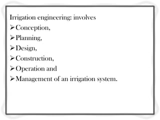
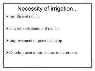
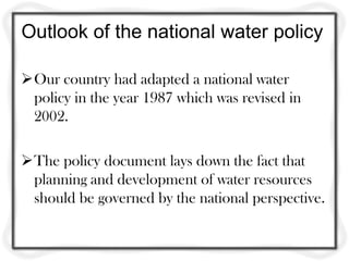
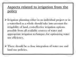
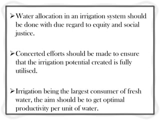
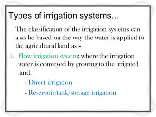
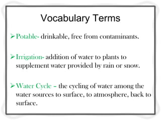
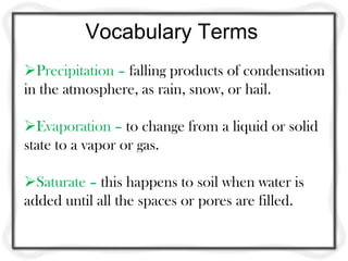
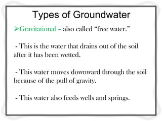
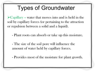
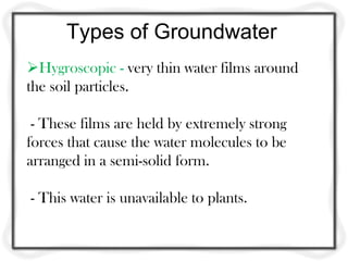
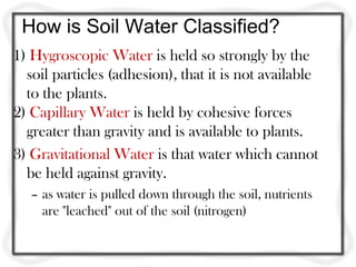
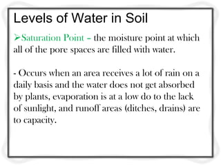
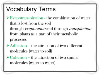
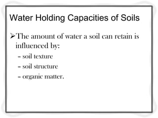
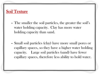
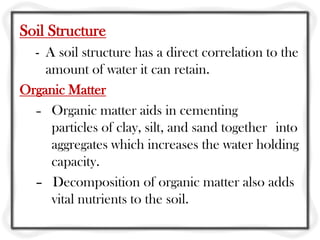
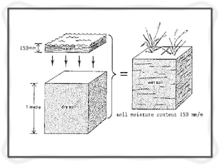
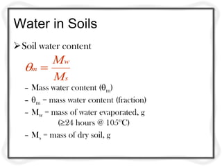
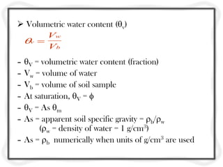
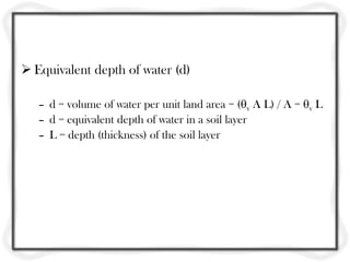
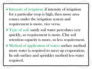
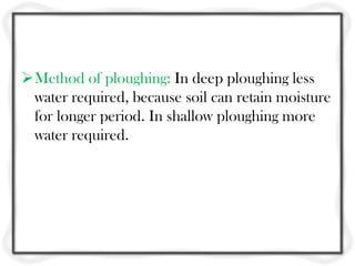
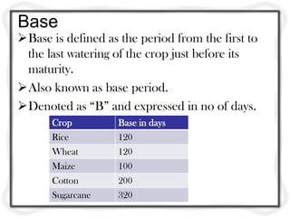
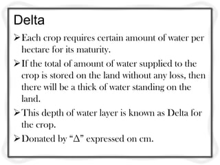
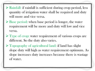
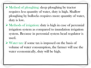
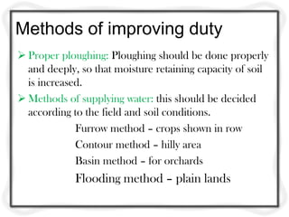
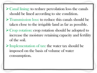
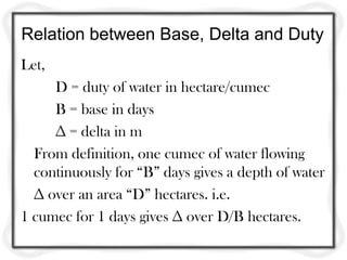
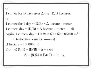
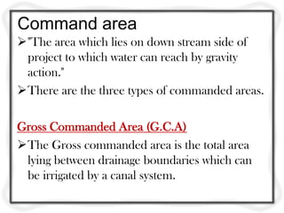
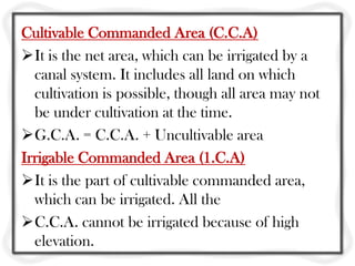
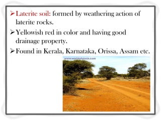
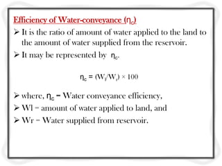
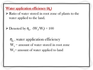
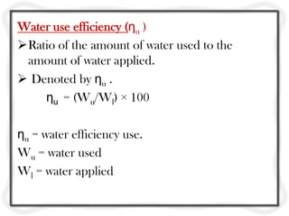
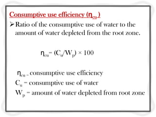
This document provides an overview of irrigation engineering. It begins with the course goals of introducing concepts related to soil, water, and plant interactions, as well as irrigation system design. Key concepts covered include the necessity of irrigation, types of irrigation systems, soil-water relationships, and classifications of irrigation schemes in India. Specifically, it discusses topics such as water content in soil, factors that influence water holding capacity, transpiration, and the relationships between soil properties, water retention, and plant growth.
Diversion head works are structures constructed across rivers to raise the water level upstream and divert water into canals. They include components like a weir, under sluices, fish ladders, divide walls, and canal head regulators. An ideal site has good foundations, allows the weir to be aligned perpendicular to flow, and has space for components while minimizing costs and environmental impacts. Weirs can be vertical drop, rock fill, or concrete, and are classified as storage, pick up, diversion, or waste based on their use and function. Diversion weirs divert river water into canals at a 90 degree angle to flow.
This document provides an introduction to irrigation engineering. It discusses the necessity of irrigation in India due to variable rainfall and the need to maximize crop production. The advantages of irrigation include increased food production, optimal crop benefits, and generation of hydroelectric power. However, disadvantages can include water pollution, rising water tables, and waterlogging from over-irrigation. The document also outlines different types of irrigation like surface, flood, and lift irrigation. It describes techniques used in India for water distribution to farms, such as free flooding, border flooding, check flooding and drip irrigation.
1. Dams are constructed across rivers to store flowing water for uses like hydropower, irrigation, water supply, flood control, and navigation.
2. The key forces acting on a gravity dam include its self-weight, which provides stability, and water pressure from the reservoir, which acts to overturn the dam. Uplift, earthquake loads, silt pressure, and ice pressure are other important forces that must be estimated based on assumptions and available data.
3. The weight of the dam per unit length is calculated based on the cross-sectional area and unit weight of the concrete or masonry used. The total weight acts at the centroid of the cross-section and is the main stabil
This document provides information on canal irrigation systems. It discusses the various components of canal distribution systems including main canals, branch canals, distributaries, minors, and watercourses. It also describes canal structures like regulators, river training works, and different types of canal falls used to change the water level. The key purpose of the document is to outline the design and components of canal irrigation networks for transporting water from its source to agricultural fields.
Subsurface water exists below the surface of the soil in two zones: the unsaturated zone (zone of aeration) and the saturated zone (zone of saturation). The unsaturated zone includes soil water and the saturated zone includes groundwater. The water table separates these two zones. In the saturated zone, all pore spaces are filled with water, while in the unsaturated zone pores are partially filled. The unsaturated zone contains three sub-zones: the soil water zone where water is immediately available to plants, the intermediate zone, and the capillary fringe where water rises through capillary action.
An aquifer is an underground layer of permeable rock or sediment that contains water. Aquifers can be confined or unconfined. A confined aquifer is separated from the surface by an impermeable layer, while an unconfined aquifer allows water to seep directly from the surface above. Natural recharge of unconfined aquifers occurs through downward percolation of excess water, while confined aquifers recharge where the aquifer reaches the surface. Infiltration galleries are underground tunnels constructed with holes to intercept groundwater flowing towards lakes or rivers and collect it for extraction.
Ground Water Resources Estimation By GEC 2015 MethodologyAnand A.V.S.S
This is the approved method using which the ground water resources of the country (India) are to be assessed. This is a modified version of GEC 1997 methodology. Presently all states are busy in assessing the Ground Water Resources for the base year 2016 using this methodology.
Dams are solid barriers constructed across rivers to store flowing water for uses like hydropower, irrigation, water supply, flood control, and navigation. The key parts of a dam include the crest, spillways, and abutments. There are several types of dams - gravity dams rely entirely on their weight for stability; buttress dams are reinforced with supports; arch dams are curved to transmit force to abutments; and earth dams are broad, trapezoidal structures built of compacted earth. The Bhakra Dam in India is the highest concrete gravity dam in Asia.
The gross command area is the total area that can be economically irrigated by an irrigation project without considering water limitations. It includes cultivable land as well as uncultivable areas like ponds, forests, and roads. When a canal system lies in a doab, which is the area between two drainages, the irrigation is more economical and the gross command area is defined as the area enclosed by the drainages on both sides.
1. River training works include guide banks, marginal banks, spurs, and pitched islands that are constructed upstream of barrages and weirs. This is to ensure the river flows through the structure and to protect upstream lands and property from submergence.
2. Marginal banks are embankments on both sides of the river that maintain the river channel and prevent submergence of upstream areas. Spurs are fortified embankments built transverse to the banks that control the river's course and protect banks from erosion. Pitched islands artificially redistribute the river's force and sediment to attract and hold the channel.
Irrigation and Hydraulic Structures
Detailed discussion on forces acting on gravity dam as per the JNTU Anantapur Autonomous syllabus.
Use full for B.Tech Civil Engineering Students
This document discusses the design of canals. It provides key terms related to canal design such as alluvial soil, silt factor, mean velocity, critical velocity, and more. It summarizes Kennedy's theory and Lacey's theory for the design of unlined canals on alluvial soils. Kennedy's theory relates critical velocity to depth while Lacey's theory relates mean velocity to hydraulic mean depth. The document also compares the two theories and lists some drawbacks of each. It provides the design procedure for both theories and references several textbooks on irrigation engineering.
This document provides information on the hydrological cycle and sources of groundwater. It begins with an overview of the hydrological cycle describing the circulation of water between the earth's atmosphere, oceans, vegetation and land. It then discusses four main sources of groundwater: wells, springs, infiltration galleries, and karez. For each source, it provides details on what they are, how they work, and examples. It concludes with sections on groundwater occurrence and exploration, outlining factors that control groundwater movement and types of investigations used to search for groundwater.
There are several types of dams classified based on size, structure, and materials. Dams are classified as large or small based on height and storage capacity. Structurally, dams include gravity dams, arch dams, arch-gravity dams, buttress dams, barrages, and embankment dams such as earthfill and rockfill dams. Earthfill dams are further divided into homogeneous, zoned, rolled fill, and hydraulic fill dams. Dams serve various purposes like water supply, flood control, irrigation, hydroelectric power and recreation. However, dams can also negatively impact the environment by disrupting natural water flows and fish migration.
Modelling of a Coastal Aquifer using FEFLOWC. P. Kumar
This document summarizes a study on modelling coastal aquifer seawater intrusion using FEFLOW software. The study area is along the coast of North Goa, India where increasing groundwater extraction is causing intrusion. The objectives are to simulate intrusion under pumping scenarios, identify sensitive parameters, and suggest remedial measures. Field investigations were conducted to collect data on groundwater levels, quality and resistivity. A 3D finite element model was set up and calibrated. Results show intrusion currently extends 290m inland but could advance farther with lower rainfall or increased pumping. Sensitive parameters include hydraulic conductivity, dispersivity and rainfall. Continuous monitoring and groundwater management are recommended.
Introduction, hydrologic cycle, climate and water m1Bibhabasu Mohanty
Introduction, Hydrologic cycle, Climate and water availability, Water balances,
Precipitation: Forms, Classification, Variability, Measurement, Data analysis, Evaporation and its measurement, Evapotranspiration and its measurement, Penman Monteith method. Infiltration: Factors affection infiltration, Horton’s equation and Green Ampt method.
Introduction to irrigation engineering 19 07 1 (1)holegajendra
This document provides information about the Water Resource Engineering course taught by Mr. Hole G.R. at J.S. Polytechnic in Pune, India. The course is divided into 6 units covering topics like introduction to irrigation and hydrology, water requirements of crops, dams and spillways, minor and micro irrigation, diversion head works, and canals. The course outcomes include estimating hydrological parameters, crop water requirements, designing dam and spillway components, executing minor irrigation schemes, and designing and maintaining canals. The first unit covers definitions of irrigation, necessity of irrigation in India, advantages and disadvantages of irrigation, classification of irrigation, and hydrological concepts. Different types of irrigation like surface, subsurface, flow, and
This document provides an overview of a syllabus for a water resource engineering course. The syllabus includes 6 units covering topics like irrigation and hydrology, water requirements of crops, dams and spillways, minor and micro irrigation, diversion head works, and canals. Key concepts from hydrology like the hydrological cycle, rainfall measurement, and types of rain gauges are also summarized. The document aims to introduce students to important concepts in irrigation engineering and hydrology.
1. Dams are constructed across rivers to store flowing water and come in various types like earth, rockfill, gravity, steel, timber and arch dams. The selection of dam type depends on site conditions like topography, geology and availability of construction materials.
2. Gravity dams derive their strength from their weight and weight of water pressure pushing them into the ground. They are made of concrete or masonry and work by balancing the water pressure on upstream side with weight and pressure on downstream side.
3. Factors considered in gravity dam design include water pressure, seismic forces, uplift pressure, weight of dam, and ensuring stability against sliding, overturning and cracking. Galleries are provided for drainage,
This is a lecture on well hydraulics. The basics of flow towards the well in confined and unconfined aquifers. Well interactions. Method of images. Flow nets in case of multiple wells. Superposition theory for multiple wells.
1. Crop water requirement is the water needed by plants for survival, growth, development and producing economic parts, which can be supplied naturally through precipitation or artificially through irrigation.
2. Irrigation water functions include supplying water for crop needs, cooling soil and plants, providing water for transpiration, dissolving minerals for nutrition, providing oxygen for metabolism, and serving as an anchor for roots.
3. Duty, which is the area irrigated by 1 cubic meter per second of water, decreases from the head of the water course to the head of the canal due to losses from evaporation and percolation as water flows through irrigation channels.
This document discusses various methods of irrigation, including surface irrigation methods like furrow irrigation, contour farming, and flooding methods. It also discusses subsurface irrigation methods like sprinkler irrigation and drip/trickle irrigation. For each method, it describes the basic components and process, as well as advantages and disadvantages. Surface irrigation methods are best suited for row crops, while sprinkler and drip irrigation methods reduce evaporation and allow more precise water and fertilizer application. Drip irrigation in particular minimizes water usage and loss. The document emphasizes matching the appropriate irrigation method to field and crop conditions.
The document discusses a course on analyzing pumping tests for groundwater aquifers. The course aims to teach participants how to determine aquifer properties through pumping tests. It covers key concepts like drawdown, specific capacity, and transmissivity. Participants will learn how to plan and optimize pumping tests, apply analytical techniques to interpret test data, and use software to analyze projects. The document provides an overview of the topics that will be covered in the course sessions, including aquifer conditions, equations for flow to wells, and methods for analyzing pumping test results.
Design of Lift Irrigation System- Angar as A Case StudyIRJET Journal
This document summarizes the design of a lift irrigation system for Angar village in Solapur district of India. Key points:
1) The lift irrigation system draws water from the Sina River via a intake well and pumps it to an elevated delivery chamber to irrigate 30 hectares of farmland using a network of gravity pipes.
2) Technical aspects of the design include selecting sites for the intake well, jack well, and delivery chamber. The command area was surveyed to determine pipe sizing and layout.
3) A cropping pattern was proposed including cotton, vegetables, onions, tomatoes, and sunflowers to maximize farm income potential from the irrigation scheme.
The document discusses specific capacity, which is a measure of well productivity calculated by dividing pumping rate by drawdown. It provides key information about specific capacity, including that it can be used to identify potential well problems, estimate aquifer transmissivity, and determine maximum pumping rates. The document also outlines best practices for specific capacity testing, such as pumping for at least 24 hours and performing semi-annual tests to monitor changes over time. Rehabilitation is recommended when specific capacity drops by 25% from initial values.
Types of dams, geological considerations in site selection, Competency of Rocks to offer stable dam foundation, effect of geological structures on dam, selection of dam site, Reservoir, purpose of reservoir, influence of water table, geological structures, life of reservoir, geophysical studies
This document summarizes four main irrigation methods: surface irrigation (flooding), sprinkler irrigation (applying water under pressure), drip or trickle irrigation (applying water slowly to the soil), and sub-surface irrigation (flooding water underground). Surface irrigation is the most widely used method, covering 90% of irrigated land. Sprinkler irrigation is ideal for scarce water areas. Drip irrigation conserves water, controls weeds, and applies water at a slow rate matching crop needs. Sub-surface irrigation is used where soil and topography allow watering underground.
The document discusses the benefits of smart irrigation control systems for Balboa Park in San Diego. It notes that previously irrigation repairs and adjustments took considerable staff time, watering windows were long, and special events could not be programmed. However, with smart irrigation control, staff time needs are less, watering windows are shorter, special events can be programmed, rain shutdown occurs automatically, issues can be addressed remotely, and seasonal adjustments and plant health have improved while erosion has decreased.
This document discusses drip irrigation, including its components, design, advantages, and benefits for farmers. It begins with an introduction to irrigation and defines drip irrigation as a micro irrigation method that applies water slowly, drop by drop, directly to a crop's root zone. It then describes the key components of a drip irrigation system, such as pumps, filters, pipes, and emitters. The document outlines the design process, including collecting soil and crop data and determining water and equipment requirements. It notes the advantages of drip irrigation include water and cost savings compared to other methods. In conclusion, drip irrigation is an efficient irrigation system that uses less water to increase yields, benefiting small-scale farmers.
This document provides an overview of irrigation engineering. It discusses the necessity of irrigation due to factors like insufficient rainfall and uneven distribution. It describes different types of irrigation systems including flow irrigation, lift irrigation, and storage irrigation. It also defines important terms used in irrigation like duty, delta, command area. The document outlines the benefits of irrigation such as increased crop yields and prosperity of farmers. It also notes some ill effects like raising water tables and creating breeding grounds for mosquitoes. Overall, the document provides a broad introduction to key concepts in irrigation engineering.
Irrigation is the artificial application of water to land or soil to assist in crop growth. Historically, irrigation was labor intensive and dependent on weather, but modern irrigation is more machine intensive, market-focused, and allows farmers to control water supply independent of rains. There are several irrigation methods, including surface irrigation where land is fully flooded, sprinkler irrigation where water is distributed through sprinklers, and drip irrigation where water is supplied drop-by-drop directly to plant roots, making it the most efficient method. While modern irrigation techniques are more costly to install initially, they are also more efficient and effective at delivering the right amount of water to increase crop yields.
Irrigation is the process of transporting water from areas with abundant supply like rivers or reservoirs to drier areas for agricultural and domestic purposes. Ancient Mesopotamians and Egyptians developed early irrigation systems using dams, reservoirs, and canals to supply water to lands away from water sources. Irrigation was invented to allow people living farther from water access to drink, grow crops, and meet other needs, and made obtaining water more reliable and regular. Today, irrigation continues to enable farming in more places and help ensure a secure food supply for more people.
Introduction:
Necessity of irrigation- scope of irrigation engineering- benefits and ill effects of irrigation- irrigation development in India- types of irrigation systems, Soil-water plant relationship: Classification of soil water- soil
moisture contents- depth of soil water available to plants-permanent
and ultimate wilting point
Water requirements of crops:
Depth of water applied during irrigation- Duty of water and deltaimprovement
of duty- command area and intensity of irrigation consumptive use of water and evapotranspiration- irrigation efficiencies- assessment of irrigation water
This document provides an overview of irrigation engineering in India. It defines irrigation engineering and discusses the necessity of irrigation given India's diverse climate and rainfall patterns. It then summarizes the history of irrigation development in India from ancient times to post-independence. The document also covers major, medium, and minor irrigation projects; water requirements of crops; principal crops in India; methods of irrigation including surface, subsurface and sprinkler; canals; tube well irrigation; dams; and issues like waterlogging and their remedial measures.
This document provides an overview of irrigation engineering. It discusses the definition and necessity of irrigation due to insufficient rainfall. The benefits of irrigation include increased crop yields and economic development, while ill effects can include rising water tables and loss of land. It then covers the history and development of irrigation in India, including the construction of canals and reservoirs. It also classifies irrigation projects and systems, such as major, medium and minor projects, as well as lift and flow irrigation systems. The document concludes by explaining soil water relationships, including water holding capacities, moisture content, and soil water constants like field capacity and wilting point.
Irrigation development in India, necessity, scope, benefits
and ill effects of irrigation, types of irrigation systems, methods of irrigation, physical
and chemical properties of soils, soil nutrients, classification of irrigable soils, suitability
of soils for irrigation, quality of irrigation water, soil water plant relations in irrigation,
measurement of soil moisture, field capacity, wilting point, available water , hydraulic
conductivity, water movement through soils.
This document provides information about an irrigation engineering course taught by Engr. Ghulam Murtaza. It includes details about the instructor, course contents, textbooks, and introductory lectures. The course covers topics such as irrigation systems in Pakistan, water resources, types of irrigation, techniques of water distribution, the Indus Water Treaty, and features of the major rivers including the Sutlej, Ravi, and Chenab rivers.
I have tried to discuss about the fundamental knowledge related to Irrigation and Flood Control in short. For more details anyone can visit the books that I have mentioned in my slide presentation. I have tried to cover major topics from books so that student can find it easy to understand and learn about irrigation and flood control. I hope it will help everyone who has interest to Irrigation Engineering.
Rainwater harvesting is a technique to collect and store rainwater runoff from rooftops, land surfaces or rock catchments. It has been used since ancient times to provide drinking water, water for livestock and irrigation. It involves three steps - catchment, conveyance and storage. Rainwater can be stored in tanks, wells, check dams or percolation tanks to recharge groundwater. Benefits include improving water resources, raising groundwater levels and mitigating droughts and floods.
1. Irrigation management involves scheduling irrigation appropriately based on soil type, crop water requirements, and other factors to efficiently use water resources.
2. Common methods of surface irrigation include border irrigation, check basin irrigation, and ridges and furrows irrigation which involve dividing fields into strips or basins and flooding or furrowing the land.
3. Factors considered in irrigation scheduling include soil type, crop water needs, available water supply, and allowing sufficient drying time between irrigations based on the crop's water depletion level. Monitoring soil moisture, plant conditions, and pan evaporation can help determine irrigation timing.
This document provides an overview of irrigation engineering. It discusses the necessity of irrigation, scope of irrigation engineering, benefits and ill-effects of irrigation, types of irrigation systems, soil-water relationships, and concepts like duty and delta. Key topics covered include different irrigation methods based on water availability and source, soil water classifications, factors affecting crop water demand, and concepts used to measure irrigation water supply and demand.
This document provides an overview of irrigation engineering. It discusses the necessity of irrigation, benefits and ill-effects. It covers types of irrigation systems, soil-water relationships, irrigation development in India, and key concepts like duty and delta. Engineering, agriculture, and management aspects are described. Factors affecting evapotranspiration and methods to measure it are also summarized.
This document contains the syllabus for the course CE8603 - Irrigation Engineering taught by A.Leema Margret, Assistant Professor at Ramco Institute of Technology, Rajapalayam. The syllabus is divided into 5 units that cover topics like crop water requirement, irrigation methods, diversion and impounding structures, canal irrigation, and water management in irrigation. Key terms discussed in Unit 1 include duty of water, delta, base period, evapotranspiration, and factors affecting duty of water. Surface irrigation methods like flow irrigation and sub-surface irrigation are also introduced.
Water resources engineering is an important branch of engineering that deals with water supply, irrigation, drainage, flood control, and water power. Irrigation is the artificial supply of water to land or soil for agricultural purposes. It is necessary in areas with insufficient rainfall to meet crop water requirements. Some key structures used in watershed management and water conservation include contour trenches, gully plugs, check dams, and gabion structures. Rainwater harvesting involves collecting and storing rainwater and is important for recharging groundwater supplies.
Alternate wetting and drying (AWD) is an irrigation practice for rice that saves water and reduces greenhouse gas emissions while maintaining yields. It involves periodically drying and re-flooding rice fields. In Bangladesh, boro rice is fully irrigated while aman rice is partly irrigated. Research shows AWD can save 15-30% of the estimated 3,000-5,000 liters of water needed to produce one kilogram of rice, without lowering yields. The practice involves irrigating until the water table is 20cm below ground, then allowing the field to partially dry before re-flooding. This technique is being validated in Bangladesh and could help conserve irrigation water and reduce environmental impacts.
Irrigation involves applying water artificially to land or soil to supply moisture for plant growth. There are various methods of irrigation that depend on the available water sources and infrastructure. Surface irrigation methods include border, check basin, and furrow irrigation. Subsurface irrigation applies water below the ground surface through underground trenches. Sprinkler and drip irrigation are pressurized methods that distribute water through pipes and emitters. The choice of irrigation method impacts water usage, uniformity of application, and suitability for different soil and crop types.
Topics:
1, Introduction to Irrigation
2. Methods of Irrigation
3. Indian Agricultural Soils
4. Methods of Improving Soil Fertility & Crop Rotation
5. Soil-Water-Plant Relationship
6. Duty and Delta
7. Depth and Frequency of Irrigation
8. Irrigation Efficiency and Water Logging
This document discusses rainwater harvesting techniques, needs, and uses. It begins by defining rainwater harvesting as collecting and storing rainwater. It then discusses various traditional rainwater harvesting methods used in India like johads in Rajasthan and tankas in Bikaner. Next, it outlines the key needs for rainwater harvesting like overcoming water shortages and declining groundwater levels. The document also discusses common urban and rural rainwater harvesting methods and provides an example of Tamil Nadu's successful rainwater harvesting movement. In conclusion, it notes that rainwater harvesting is most viable in regions receiving moderate to high average rainfall.
An agricultural land is said to be waterlogging when the soil pores within the roof zone of the crops are saturated to such an extent that normal circulation of air within the soil pores is totally cut off and productivity of soil is affected. Waterlogging generally occurs because of over-irrigation , high water table and the poor water management.
The yield of crop is adversely affected when the depth of water table is equal to or less then the one given below.
Ground water recharge & water logging by Nikhil PakwanneNIKHIL PAKWANNE
The document discusses various methods of artificial groundwater recharging including (1) spreading method, (2) injection well method, and (3) river bank filtration method. It also covers subsurface drainage system layouts such as natural system, grid iron system, herringbone system, and double main system. Managing groundwater is important for irrigation and preventing issues like waterlogging.
Similar to Irrigationengineeringm1 120625051631-phpapp01 (20)
Dr. Sean Tan, Head of Data Science, Changi Airport Group
Discover how Changi Airport Group (CAG) leverages graph technologies and generative AI to revolutionize their search capabilities. This session delves into the unique search needs of CAG’s diverse passengers and customers, showcasing how graph data structures enhance the accuracy and relevance of AI-generated search results, mitigating the risk of “hallucinations” and improving the overall customer journey.
How to Get CNIC Information System with Paksim Ga.pptxdanishmna97
Pakdata Cf is a groundbreaking system designed to streamline and facilitate access to CNIC information. This innovative platform leverages advanced technology to provide users with efficient and secure access to their CNIC details.
Unlock the Future of Search with MongoDB Atlas_ Vector Search Unleashed.pdfMalak Abu Hammad
Discover how MongoDB Atlas and vector search technology can revolutionize your application's search capabilities. This comprehensive presentation covers:
* What is Vector Search?
* Importance and benefits of vector search
* Practical use cases across various industries
* Step-by-step implementation guide
* Live demos with code snippets
* Enhancing LLM capabilities with vector search
* Best practices and optimization strategies
Perfect for developers, AI enthusiasts, and tech leaders. Learn how to leverage MongoDB Atlas to deliver highly relevant, context-aware search results, transforming your data retrieval process. Stay ahead in tech innovation and maximize the potential of your applications.
#MongoDB #VectorSearch #AI #SemanticSearch #TechInnovation #DataScience #LLM #MachineLearning #SearchTechnology
Pushing the limits of ePRTC: 100ns holdover for 100 daysAdtran
At WSTS 2024, Alon Stern explored the topic of parametric holdover and explained how recent research findings can be implemented in real-world PNT networks to achieve 100 nanoseconds of accuracy for up to 100 days.
GraphSummit Singapore | The Future of Agility: Supercharging Digital Transfor...Neo4j
Leonard Jayamohan, Partner & Generative AI Lead, Deloitte
This keynote will reveal how Deloitte leverages Neo4j’s graph power for groundbreaking digital twin solutions, achieving a staggering 100x performance boost. Discover the essential role knowledge graphs play in successful generative AI implementations. Plus, get an exclusive look at an innovative Neo4j + Generative AI solution Deloitte is developing in-house.
TrustArc Webinar - 2024 Global Privacy SurveyTrustArc
How does your privacy program stack up against your peers? What challenges are privacy teams tackling and prioritizing in 2024?
In the fifth annual Global Privacy Benchmarks Survey, we asked over 1,800 global privacy professionals and business executives to share their perspectives on the current state of privacy inside and outside of their organizations. This year’s report focused on emerging areas of importance for privacy and compliance professionals, including considerations and implications of Artificial Intelligence (AI) technologies, building brand trust, and different approaches for achieving higher privacy competence scores.
See how organizational priorities and strategic approaches to data security and privacy are evolving around the globe.
This webinar will review:
- The top 10 privacy insights from the fifth annual Global Privacy Benchmarks Survey
- The top challenges for privacy leaders, practitioners, and organizations in 2024
- Key themes to consider in developing and maintaining your privacy program
Let's Integrate MuleSoft RPA, COMPOSER, APM with AWS IDP along with Slackshyamraj55
Discover the seamless integration of RPA (Robotic Process Automation), COMPOSER, and APM with AWS IDP enhanced with Slack notifications. Explore how these technologies converge to streamline workflows, optimize performance, and ensure secure access, all while leveraging the power of AWS IDP and real-time communication via Slack notifications.
Communications Mining Series - Zero to Hero - Session 1DianaGray10
This session provides introduction to UiPath Communication Mining, importance and platform overview. You will acquire a good understand of the phases in Communication Mining as we go over the platform with you. Topics covered:
• Communication Mining Overview
• Why is it important?
• How can it help today’s business and the benefits
• Phases in Communication Mining
• Demo on Platform overview
• Q/A
For the full video of this presentation, please visit: https://www.edge-ai-vision.com/2024/06/building-and-scaling-ai-applications-with-the-nx-ai-manager-a-presentation-from-network-optix/
Robin van Emden, Senior Director of Data Science at Network Optix, presents the “Building and Scaling AI Applications with the Nx AI Manager,” tutorial at the May 2024 Embedded Vision Summit.
In this presentation, van Emden covers the basics of scaling edge AI solutions using the Nx tool kit. He emphasizes the process of developing AI models and deploying them globally. He also showcases the conversion of AI models and the creation of effective edge AI pipelines, with a focus on pre-processing, model conversion, selecting the appropriate inference engine for the target hardware and post-processing.
van Emden shows how Nx can simplify the developer’s life and facilitate a rapid transition from concept to production-ready applications.He provides valuable insights into developing scalable and efficient edge AI solutions, with a strong focus on practical implementation.
Sudheer Mechineni, Head of Application Frameworks, Standard Chartered Bank
Discover how Standard Chartered Bank harnessed the power of Neo4j to transform complex data access challenges into a dynamic, scalable graph database solution. This keynote will cover their journey from initial adoption to deploying a fully automated, enterprise-grade causal cluster, highlighting key strategies for modelling organisational changes and ensuring robust disaster recovery. Learn how these innovations have not only enhanced Standard Chartered Bank’s data infrastructure but also positioned them as pioneers in the banking sector’s adoption of graph technology.
Best 20 SEO Techniques To Improve Website Visibility In SERPPixlogix Infotech
Boost your website's visibility with proven SEO techniques! Our latest blog dives into essential strategies to enhance your online presence, increase traffic, and rank higher on search engines. From keyword optimization to quality content creation, learn how to make your site stand out in the crowded digital landscape. Discover actionable tips and expert insights to elevate your SEO game.
Essentials of Automations: The Art of Triggers and Actions in FMESafe Software
In this second installment of our Essentials of Automations webinar series, we’ll explore the landscape of triggers and actions, guiding you through the nuances of authoring and adapting workspaces for seamless automations. Gain an understanding of the full spectrum of triggers and actions available in FME, empowering you to enhance your workspaces for efficient automation.
We’ll kick things off by showcasing the most commonly used event-based triggers, introducing you to various automation workflows like manual triggers, schedules, directory watchers, and more. Plus, see how these elements play out in real scenarios.
Whether you’re tweaking your current setup or building from the ground up, this session will arm you with the tools and insights needed to transform your FME usage into a powerhouse of productivity. Join us to discover effective strategies that simplify complex processes, enhancing your productivity and transforming your data management practices with FME. Let’s turn complexity into clarity and make your workspaces work wonders!
Building Production Ready Search Pipelines with Spark and MilvusZilliz
Spark is the widely used ETL tool for processing, indexing and ingesting data to serving stack for search. Milvus is the production-ready open-source vector database. In this talk we will show how to use Spark to process unstructured data to extract vector representations, and push the vectors to Milvus vector database for search serving.
Threats to mobile devices are more prevalent and increasing in scope and complexity. Users of mobile devices desire to take full advantage of the features
available on those devices, but many of the features provide convenience and capability but sacrifice security. This best practices guide outlines steps the users can take to better protect personal devices and information.
Maruthi Prithivirajan, Head of ASEAN & IN Solution Architecture, Neo4j
Get an inside look at the latest Neo4j innovations that enable relationship-driven intelligence at scale. Learn more about the newest cloud integrations and product enhancements that make Neo4j an essential choice for developers building apps with interconnected data and generative AI.
2. Content…
Necessity of irrigation- scope of irrigation
engineering- benefits and ill effects of irrigation-
irrigation development in India- types of
irrigation systems, Soil-water plant relationship:
Classification of soil water- soil moisture
contents- depth of soil water available to plants-
permanent and ultimate wilting point
3. Course goals
This course has two specific goals:
(i) To introduce students to basic concepts of soil,
water, plants, their interactions, as well as irrigation and
drainage systems design, planning and management.
(ii) To develop analytical skills relevant to the areas
mentioned in (i) above, particularly the design of
irrigation and drainage projects.
4. Introduction...
Irrigation is the artificial application of water to the
land or soil.
It is used to assist in the growing of agricultural crops,
maintenance of landscapes, and revegetation of
disturbed soils in dry areas and during periods of
inadequate rainfall.
Irrigation is often studied together with drainage,
which is the natural or artificial removal of surface and
sub-surface water from a given area.
7. Benefits of irrigation...
Increase in crop yield
Protection from famine
Cultivation of superior crops
Elimination of mixed cropping
Economic development
Hydro power generation
Domestic and industrial water supply
8. ill effects of irrigation...
Rising of water table
Formation of marshy land
Dampness in weather
Loss of valuable lands
9.
10. Irrigation development in India...
• Among Asian countries India has largest arable
land (40%).
• Only USA has more arable land than India.
• In a monsoon climate and an agrarian economy
like India, irrigation has played a major role in
the production process. There is evidence of
the practice of irrigation since the establishment
of settled agriculture during the Indus Valley
Civilization (2500 BC).
11. These irrigation technologies were in the form
of small and minor works, which could be
operated by small households to irrigate small
patches of land and did not require co-operative
effort.
In the south, perennial irrigation may have
begun with construction of the Grand Anicut by
the Cholas as early as second century to provide
irrigation from the Cauvery river.
12. At beginning of 19th century, there was large no
of water tanks in peninsular India and several
canals in northern India were build.
The upper Ganga canal, upper Bari Doab canal
and the Krishna and Godavari delta system
were constructed between 1836-1866.
During the last fifty years, gross irrigated area
(GIA) of India has increased more than three
fold from 22 to 76 million Hectares.
14. Groundwater irrigation in India developed
during the period of green revolution and
contributed much in increasing the gross
irrigated area of the country.
In the last five decades, groundwater irrigation
has increased from 5 million hectares to
35million hectares.
15. Classification of irrigation schemes ...
Irrigation projects in India are classified into
three categories
major
medium &
minor
according to the area cultivated.
16. 1) Major irrigation projects: projects which have a
culturable command area (CCA) of more than
10,000 ha but more than 2,000 ha utilize mostly
surface water resources.
2) Medium irrigation projects: projects which
have CCA less than 10,000 ha. But more than
2,000 ha utilizes mostly surface water resources.
3) Minor irrigation projects: projects with CCA
less than or equal to 2,000 ha. utilizes both
ground water and local surface water resources.
17. Outlook of the national water policy
Our country had adapted a national water
policy in the year 1987 which was revised in
2002.
The policy document lays down the fact that
planning and development of water resources
should be governed by the national perspective.
18. Aspects related to irrigation from the
policy
Irrigation planning either in an individual project or in
a watershed as a whole should take into account the
irrigability of land, cost-effective irrigation options
possible from all available sources of water and
appropriate irrigation techniques for optimizing water
use efficiency.
There should be a close integration of water use and
land use policies.
19. Water allocation in an irrigation system should
be done with due regard to equity and social
justice.
Concerted efforts should be made to ensure
that the irrigation potential created is fully
utilised.
Irrigation being the largest consumer of fresh
water, the aim should be to get optimal
productivity per unit of water.
20. Types of irrigation systems...
The classification of the irrigation systems can
also be based on the way the water is applied to
the agricultural land as –
1. Flow irrigation system: where the irrigation
water is conveyed by growing to the irrigated
land.
- Direct irrigation
- Reservoir/tank/storage irrigation
21. 2. Lift irrigation system: Where the irrigation
water is available at a level lower than that of the
land to be irrigated and hence the water is lifted
up by pumps or by other mechanical devices
for lifting water and conveyed to the agricultural
land through channels flowing under gravity.
22. Classification of irrigation systems may also be
made on the basis of duration of the applied
water.
1. Inundation/flooding type irrigation system: In
which large quantities of water flowing in a river
during floods is allowed to inundate the land to be
cultivated, thereby saturating the soil.
- The excess water is then drained off and the land is
used for cultivation.
- It is also common in the areas near river deltas,
where the slope of the river and land is small.
23. 2. Perennial irrigation system: In which irrigation
water is supplied according to the crop water
requirement at regular intervals, throughout the
life cycle of the crop.
- The water for such irrigation may be obtained
from rivers or from wells.
24. Some important terms
1. Culturable Command Area (CCA): The gross
command area contains unfertile barren land,
alkaline soil, local ponds, villages and other
areas as habitation.
These areas are called unculturable areas. The
remaining area on which crops can be grown
satisfactorily is known as cultivable command
area (CCA).
25. Culturable command area can further be
divided into 2 categories
Culturable cultivated area: It is the area in which
crop is grown at a particular time or crop season.
Culturable uncultivated area: It is the area in which
crop is not sown in a particular season.
26. 2. Gross command area (GCA): The total area lying
between drainage boundaries which can be
commanded or irrigated by a canal system.
G.C.A = C.C.A + unculturable area
3. Water Tanks: These are dug areas of lands for storing
excess rain water.
27. 4. Water logged area: An agricultural land is said to be
waterlogged when its productivity or fertility is affected
by high water table.
The depth of water-table at which it tends to make the
soil water-logged and harmful to the growth and
subsistence of plant life depends upon the height of
capillary fringe.
The height of capillary fringe is more for fine grained
soil and less for coarse grained ones.
28. 5. Outlet: This is a small structure which admits
water from the distributing channel to a water
course of field channel. Thus an outlet is a sort
of head regulator for the field channel
delivering water to the irrigation fields.
6. Permanent wilting point: or the wilting
coefficient is that water content at which plants
can no longer extract sufficient water from the
soil for its growth.
31. Vocabulary Terms
Potable- drinkable, free from contaminants.
Irrigation- addition of water to plants to
supplement water provided by rain or snow.
Water Cycle – the cycling of water among the
water sources to surface, to atmosphere, back to
surface.
32. Vocabulary Terms
Precipitation – falling products of condensation
in the atmosphere, as rain, snow, or hail.
Evaporation – to change from a liquid or solid
state to a vapor or gas.
Saturate – this happens to soil when water is
added until all the spaces or pores are filled.
33. Types of Groundwater
Gravitational – also called “free water.”
- This is the water that drains out of the soil
after it has been wetted.
- This water moves downward through the soil
because of the pull of gravity.
- This water also feeds wells and springs.
34. Types of Groundwater
Capillary – water that moves into and is held in the
soil by capillary forces (or pertaining to the attraction
or repulsion between a solid and a liquid).
- Plant roots can absorb or take up this moisture.
- The size of the soil pore will influence the
amount of water held by capillary forces.
- Provides most of the moisture for plant growth.
35. Types of Groundwater
Hygroscopic - very thin water films around
the soil particles.
- These films are held by extremely strong
forces that cause the water molecules to be
arranged in a semi-solid form.
- This water is unavailable to plants.
36. How is Soil Water Classified?
1) Hygroscopic Water is held so strongly by the
soil particles (adhesion), that it is not available
to the plants.
2) Capillary Water is held by cohesive forces
greater than gravity and is available to plants.
3) Gravitational Water is that water which cannot
be held against gravity.
– as water is pulled down through the soil, nutrients
are "leached" out of the soil (nitrogen)
37. Levels of Water in Soil
Saturation Point – the moisture point at which
all of the pore spaces are filled with water.
- Occurs when an area receives a lot of rain on a
daily basis and the water does not get absorbed
by plants, evaporation is at a low do to the lack
of sunlight, and runoff areas (ditches, drains) are
to capacity.
38. Levels of Water in Soil
Field Capacity – the maximum amount of
water left in the soil after losses of water to the
forces of gravity have ceased and before surface
evaporation begins.
- Occurs when the soil contains the maximum
amount of capillary water.
39. Levels of Water in Soil
Wilting Point – the point at which the plant
can no longer obtain sufficient water from the
soil to meet its transpiration needs.
- At this point the plant enters permanent wilt
and dies.
40. Levels of Water in Soil
Available Soil Water – that amount present
in a soil which can be moved by plants.
- It is designated as the difference between the
field capacity and the wilting point.
41. The Hydrolic (Water) Cycle
Water is constantly moving
through the atmosphere and
into and out of the soil.
Soil moisture is one portion
of the cycle which can be
controlled to the greatest extent
by affecting the soil.
42. How Does Water Enter the Soil?
through pores in the soil
sandy soils have the largest pores, but are
often filled with other material
medium textured soils (loamy) have good
water entry properties
clays, pores swell shut when they get wet
44. Vocabulary Terms
Water Holding Capacity – is a soil property
which represents the amount of water a soil can
retain after it has been saturated by rain and
downward movement has ceased.
Transpiration – the process by which water, as a
vapor, is lost by living plants.
45. Vocabulary Terms
Translocation – the process by which water
moves through a plant from the roots to the
leaves.
Wilting Point – the moisture content of a soil in
which growing plants wilt and will not recover
after water is added.
46. Vocabulary Terms
Evapotranspiration - the combination of water
that is lost from the soil
through evaporation and through transpiration
from plants as a part of their metabolic
processes
Adhesion – the attraction of two different
molecules (water to soil)
Cohesion – the attraction of two similar
molecules (water to water)
47. Water Holding Capacities of Soils
The amount of water a soil can retain is
influenced by:
– soil texture
– soil structure
– organic matter.
48. Soil Texture
– The smaller the soil particles, the greater the soil’s
water holding capacity. Clay has more water
holding capacity than sand.
– Small soil particles (clay) have more small pores or
capillary spaces, so they have a higher water holding
capacity. Large soil particles (sand) have fewer
capillary spaces, therefore less ability to hold water.
49. Soil Structure
- A soil structure has a direct correlation to the
amount of water it can retain.
Organic Matter
– Organic matter aids in cementing
particles of clay, silt, and sand together into
aggregates which increases the water holding
capacity.
– Decomposition of organic matter also adds
vital nutrients to the soil.
52. Bulk Density (b)
– b = soil bulk density, g/cm3
– Ms = mass of dry soil, g
– Vb = volume of soil sample, cm3
Typical values: 1.1 - 1.6 g/cm3
Particle Density (p)
– P = soil particle density, g/cm3
– Ms = mass of dry soil, g
– Vs = volume of solids, cm3
Typical values: 2.6 - 2.7 g/cm3
b
s
b
V
M
p
s
s
M
V
54. Soil moisture content
The soil moisture content indicates the amount
of water present in the soil.
It is commonly expressed as the amount of
water (in mm of water depth) present in a depth
of one metre of soil.
For example: when an amount of water (in mm
of water depth) of 150 mm is present in a depth
of one metre of soil, the soil moisture content is
150 mm/m
55.
56. Water in Soils
Soil water content
– Mass water content (m)
– m = mass water content (fraction)
– Mw = mass of water evaporated, g
(24 hours @ 105o
C)
– Ms = mass of dry soil, g
s
w
m
M
M
57. Volumetric water content (v)
– V = volumetric water content (fraction)
– Vw = volume of water
– Vb = volume of soil sample
– At saturation, V =
– V = As m
– As = apparent soil specific gravity = b/w
(w = density of water = 1 g/cm3)
– As = b numerically when units of g/cm3 are used
v
w
b
V
V
58. Equivalent depth of water (d)
– d = volume of water per unit land area = (v A L) / A = v L
– d = equivalent depth of water in a soil layer
– L = depth (thickness) of the soil layer
60. Volumetric Water Content & Equivalent Depth
Typical Values for Agricultural Soils
1 in.
0.50 in.
0.15 in.
0.20 in.
0.15 in.
Soil Solids (Particles): 50%
Total Pore
Space: 50%
Very Large Pores: 15%
(Gravitational Water)
Medium-sized Pores: 20%
(Plant Available Water)
Very Small Pores: 15%
(Unavailable Water)
61. Water-Holding Capacity of Soil
Effect of Soil Texture
Coarse Sand Silty Clay Loam
Gravitational Water
Water Holding Capacity
Available Water
Unavailable Water
Dry Soil
62. Soil water constants
For a particular soil, certain soil water
proportions are defined which dictate whether
the water is available or not for plant growth.
These are called the soil water constants, which
are described below.
63. Saturation capacity: this is the total water
content of the soil when all the pores of the soil
are filled with water.
It is also termed as the maximum water holding
capacity of the soil.
At saturation capacity, the soil moisture tension
is almost equal to zero.
64. Field capacity: this is the water retained by an
initially saturated soil against the force of gravity.
Hence, as the gravitational water gets drained
off from the soil, it is said to reach the field
capacity.
At field capacity, the macro-pores of the soil
are drained off, but water is retained in the
micropores.
65. Permanent wilting point: plant roots are able to
extract water from a soil matrix, which is
saturated up to field capacity.
However, as the water extraction proceeds, the
moisture content diminishes and the negative
pressure increases.
At one point, the plant cannot extract any
further water and thus wilts.
66. Two stages of wilting points are recognized and
they are:
Temporary wilting point: this denotes the soil
water content at which the plant wilts at day
time, but recovers during right or when water is
added to the soil.
Ultimate wilting point: at such a soil water
content, the plant wilts and fails to regain life
even after addition of water to soil.
67. It must be noted that the above water contents
are expressed as percentage of water held in the
soil pores, compared to a fully saturated soil.
68.
69. Available Water
Water held in the soil between field capacity and
permanent wilting point
“Available” for plant use
Available Water Capacity (AWC)
– AWC = fc - wp
– Units: depth of available water per unit depth of soil,
“unitless” (in/in, or mm/mm)
– Measured using field or laboratory methods
71. Fraction available water depleted (fd)
– (fc - v) = soil water deficit (SWD)
– v = current soil volumetric water content
Fraction available water remaining (fr)
– (v - wp) = soil water balance (SWB)
wpfc
vfc
df
wpfc
wpv
rf
72. Total Available Water (TAW)
TAW = (AWC) (Rd)
– TAW = total available water capacity within the plant
root zone, (inches)
– AWC = available water capacity of the soil,
(inches of H2O/inch of soil)
– Rd = depth of the plant root zone, (inches)
– If different soil layers have different AWC’s, need to
sum up the layer-by-layer TAW’s
TAW = (AWC1) (L1) + (AWC2) (L2) + . . . (AWCN)
(LN)
- L = thickness of soil layer, (inches)
- 1, 2, N: subscripts represent each successive soil layer
73. Depth of Penetration
Can be viewed as sequentially filling the soil
profile in layers
Deep percolation: water penetrating deeper
than the bottom of the root zone
Leaching: transport of chemicals from the root
zone due to deep percolation
76. Content…
Depth of water applied during irrigation- Duty
of water and delta improvement of duty-
command area and intensity of irrigation
consumptive use of water and
Evapotranspiration- irrigation efficiencies-
assessment of irrigation water.
77. Introduction…
The term water requirements of a crop means
the total quantity of all water and the way in
which a crop requires water, from the time it is
sown to the time it is harvested.
The water requirement of crop varies with the
crop as well as with the place.
The same crop may have different water
requirements at different places of the same
country.
78. Factors affecting water requirement
Water table: high water table less requirement,
vice versa.
Climate: In hot climate evaporation loss is
more, hence requirement more, vice versa.
Ground slope: ground is steep, the water flows
down very quickly and soil gets little time to
absorb, so requirement more. If ground is flat
less requirement.
79. Intensity of irrigation: if intensity of irrigation
for a particular crop is high, then more area
comes under the irrigation system and
requirement is more, vice versa.
Type of soil: sandy soil water percolates very
quickly, so requirement is more. Clay soil
retention capacity is more, so less requirement.
Method of application of water: surface method
more water is required to meet up evaporation.
In sub surface and sprinkler method less water
required.
80. Method of ploughing: In deep ploughing less
water required, because soil can retain moisture
for longer period. In shallow ploughing more
water required.
81. Base
Base is defined as the period from the first to
the last watering of the crop just before its
maturity.
Also known as base period.
Denoted as “B” and expressed in no of days.
Crop Base in days
Rice 120
Wheat 120
Maize 100
Cotton 200
Sugarcane 320
82. Delta
Each crop requires certain amount of water per
hectare for its maturity.
If the total of amount of water supplied to the
crop is stored on the land without any loss, then
there will be a thick of water standing on the
land.
This depth of water layer is known as Delta for
the crop.
Donated by “∆” expressed on cm.
83. Kharif crop Delta in cm
Rice 125
Maize 45
Ground nut 30
Millet 30
Rabi crop Delta in cm
Wheat 40
Mustard 45
Gram 30
Potato 75
84. Duty
Duty of water is defined as no of hectares that
can be irrigated by constant supply of water at
the rate of one cumec throughout the base
period.
Denoted as “D” and expressed in
hectares/cumec.
Varies with soil condition, method of
ploughing, method of application of water.
1 cumec-day = 1 m3/sec for one day.
86. Factors affecting duty
Soil characteristics: if soil of the canal bed is
porous and coarse grained, it leads to more
seepage loss and low duty. If soil is compact
and close grained, seepage loss will less and
high duty.
Climatic condition: when atmospheric temp. of
command area becomes high, the evaporation
loss is more and duty becomes low and vice
versa.
87. Rainfall: if rainfall is sufficient during crop period, less
quantity of irrigation water shall be required and duty
will more and vice versa.
Base period: when base period is longer, the water
requirement will be more and duty will low and vice
versa.
Type of crop: water requirement of various crops are
different. So the duty also varies.
Topography of agricultural land: if land has slight
slope duty will high as water requirement optimum. As
slope increases duty increases because there is wastage
of water.
88. Method of ploughing: deep ploughing by tractor
requires less quantity of water, duty is high. Shallow
ploughing by bullocks requires more quantity of water,
duty is low.
Methods of irrigation: duty is high in case of perennial
irrigation system as compared to inundation irrigation
system. Because in perennial system head regulator is
used.
Water tax: if some tax is imposed on the basis of
volume of water consumption, the farmer will use the
water economically, duty will be high.
89. Methods of improving duty
Proper ploughing: Ploughing should be done properly
and deeply, so that moisture retaining capacity of soil
is increased.
Methods of supplying water: this should be decided
according to the field and soil conditions.
Furrow method – crops shown in row
Contour method – hilly area
Basin method – for orchards
Flooding method – plain lands
90. Canal lining: to reduce percolation loss the canals
should be lined according to site condition.
Transmission loss: to reduce this canals should be
taken close to the irrigable land as far as possible.
Crop rotation: crop rotation should be adopted to
increase the moisture retaining capacity and fertility
of the soil.
Implementation of tax: the water tax should be
imposed on the basis of volume of water
consumption.
91. Relation between Base, Delta and Duty
Let,
D = duty of water in hectare/cumec
B = base in days
∆ = delta in m
From definition, one cumec of water flowing
continuously for “B” days gives a depth of water
∆ over an area “D” hectares. i.e.
1 cumec for 1 days gives ∆ over D/B hectares.
92. or
1 cumec for B days gives ∆ over D/B hectares.
or
1 cumec for 1 day = (D/B) × ∆ hectare – meter
1 cumec- day = (D/B) × ∆ hectare – meter ----- (i)
Again, 1 cumec- day = 1 × 24 × 60 × 60 = 86400 m3 =
8.64 hectare – meter ------- (ii)
(1 hectare = 10, 000 m2)
From (i) & (ii) = (D/B) × ∆ = 8.64
∆ = (8.64 × B)/ D = in m.
93. Command area
"The area which lies on down stream side of
project to which water can reach by gravity
action."
There are the three types of commanded areas.
Gross Commanded Area (G.C.A)
The Gross commanded area is the total area
lying between drainage boundaries which can
be irrigated by a canal system.
94. Cultivable Commanded Area (C.C.A)
It is the net area, which can be irrigated by a
canal system. It includes all land on which
cultivation is possible, though all area may not
be under cultivation at the time.
G.C.A. = C.C.A. + Uncultivable area
Irrigable Commanded Area (1.C.A)
It is the part of cultivable commanded area,
which can be irrigated. All the
C.C.A. cannot be irrigated because of high
elevation.
95. Intensity of Irrigation
It is the ratio of area irrigated per season to total
irrigable areas or small projects is based on this.
96. Types of soil
Alluvial soil: formed by deposition of silt carried by
river water during flood.
Silt is formed due to weathering action of rocks by
heavy current of river water in the hilly regions.
Found in Indo –Gangetic plains, Brahmaputra plains.
97. Black soil: originated by weathering action on
rocks like granite, basalt etc.
Mainly found in AP, MP, TN, Gujarat.
They are sticky when wet and very hard when
dry.
Suitable for
cultivation of cotton.
98. Red soil: formed by weathering action of rocks
of igneous and metamorphic group.
Water absorbing capacity very low.
Found in Karnataka, TN, Orissa, WB,
Maharashtra etc.
99. Laterite soil: formed by weathering action of
laterite rocks.
Yellowish red in color and having good
drainage property.
Found in Kerala, Karnataka, Orissa, Assam etc.
100. Consumptive use of water
It is defined as total quantity of water used for
the growth of plants by transpiration and the
amount of lost by evaporation.
It is also known as evapo-transpiration.
Expressed in hectare-meter or as depth of water
in m.
The value of consumptive use of water is vary
from crop to crop, time to time, place to place.
101. Evapotranspiration
a) Evaporation: The process by which water is changed
from the liquid or solid state into the gaseous state
through the transfer of heat energy.
b) Transpiration: The evaporation of water absorbed
by the crop which is used directly in the building of
plant tissue in a specified time. It does not include soil
evaporation.
c) Evapotranspiration, ET: It is the sum of the amount
of water transpired by plants during the growth process
and that amount that is evaporated from soil and
vegetation in the domain occupied by the growing
crop. ET is normally expressed in mm/day.
102. Factors that affect Evapotranspiration
Weather parameters
Crop Characteristics
Management and Environmental aspects are
factors affecting ET
103. Weather Parameters:
The principal weather conditions affecting
Evapotranspiration are:
Radiation
Air temperature
Humidity and
Wind speed.
104. Crop characteristics that affect ET :
Crop Type
Variety of Crop
Development Stage
Crop Height
Crop Roughness
Ground Cover
Crop Rooting Depth
105. Management and Environmental Factors :
Factors such as soil salinity,
Poor land fertility,
Limited application of fertilizers,
Absence of control of diseases and
Pests and poor soil management
May limit the crop development and
reduce soil Evapotranspiration.
106. Other factors that affect ET are ground cover,
plant density and soil water content.
The effect of soil water content on ET is
conditioned primarily by the magnitude of the
water deficit and the type of soil.
Too much water will result in water logging
which might damage the root and limit root
water uptake by inhibiting respiration.
107. Determination of ET
Evapotranspiration is not easy to measure.
Specific devices and accurate measurements of
various physical parameters or the soil water
balance in lysimeters are required to determine
ET.
The methods are expensive, demanding and
used for research purposes.
They remain important for evaluating ET
estimates obtained by more indirect methods.
108. Water Balance Method
The Water Balance or Budget Method is a
measurement of continuity of flow of water.
This method consists of drawing up a balance sheet of
all the water entering and leaving a particular
catchment or drainage basin.
The water balance equation can be written as:
ET = I + P – RO – DP + CR + SF + SW
Where: I is Irrigation, P is rainfall, RO is surface
runoff, DP is deep percolation, CR is capillary rise,
SF and SW are change in sub-surface flow and change
in soil water content respectively
109. Lysimeter Method
A water tight tank of cylindrical shape having dia about
2 m and depth about 3 m is placed vertically in
ground.
The tank is filled with sample soil.
Bottom of the tank consists of sand layer and a pan for
collecting surplus water.
The consumptive use of water is measured by the
amount of water required for the satisfactory growth of
plants with in tank.
Cu = Wa - Wd (Cu = consumptive use, Wa = water
applied, Wd = Water drained off)
110.
111. Field experimental method
Some fields are selected for expt.
The quantity of water is applied in such a way
that it is sufficient for satisfactory growth of
crops.
There should be no percolation or deep runoff.
If there is any runoff it should be measured and
deducted from the total quantity of water
applied.
112. Soil moisture study
Several plots of land are selected where irrigation
water is to be supplied.
The soil samples are taken from diff depths at the root
zone of the plants before and after irrigation.
Then water contents of the soil samples are
determined by laboratory tests.
The depth of water removed from soil determined by
Dr = pwd/ 100
(Dr= depth of water removed in m, p = % of water
content, w = sp. Gr. Of soil, d= depth of soil in m)
113. The total quantity of water removed in 30 days
period is calculated.
Then a curve of water consumption versus time
is prepared.
From this curve the water consumption for any
period can be calculated.
114. Irrigation efficiencies
Efficiency is the ratio of the water output to the water
input, and is usually expressed as percentage.
Input minus output is nothing but losses, and hence, if
losses are more, output is less and, therefore,
efficiency is less.
Hence, efficiency is inversely proportional to the
losses.
Water is lost in irrigation during various processes
and, therefore, there are different kinds of irrigation
efficiencies.
115. Efficiency of Water-conveyance (ηc)
It is the ratio of amount of water applied to the land to
the amount of water supplied from the reservoir.
It may be represented by ηc.
ηc = (Wl/Wr) × 100
where, ηc = Water conveyance efficiency,
Wl = amount of water applied to land, and
Wr = Water supplied from reservoir.
116. Water application efficiency (ηa)
Ratio of water stored in root zone of plants to the
water applied to the land.
Denoted by ηa= (Wz/Wl) × 100
ηa = water application efficiency
Wz = amount of water stored in root zone
Wl = amount of water applied to land
117. Water use efficiency (ηu )
Ratio of the amount of water used to the
amount of water applied.
Denoted by ηu .
ηu = (Wu/Wl) × 100
ηu = water efficiency use.
Wu = water used
Wl = water applied
118. Consumptive use efficiency (ηcu )
Ratio of the consumptive use of water to the
amount of water depleted from the root zone.
ηcu= (Cu/Wp) × 100
ηcu = consumptive use efficiency
Cu = consumptive use of water
Wp = amount of water depleted from root zone
119. Standard of irrigation water
Constituent Long-term use (mg/L) Short-term use (mg/L)
Aluminum 5.0 20.0
Arsenic 0.10 2.0
Beryllium 0.10 0.5
Boron 0.75 2.0
Chromium 0.1 1.0
Cobalt 0.05 5.0
Copper 0.2 5.0
Fluoride 1.0 15.0
Iron 5.0 20.0
Lead 5.0 10.0
Manganese 0.2 10.0
Nickel 0.2 20.0
Zinc 0.2 10.0
120. Methods of Measuring Irrigation Water
a) Direct method: Collect water in a contained of known
volume e.g. bucket. Measure the time required for water from
an irrigation source e.g. siphon to fill the bucket.
Flow rate = Volume/time m3/hr or L/s etc.
b) Weirs: Weirs are regular notches over which water flows.
They are used to regulate floods through rivers, overflow dams
and open channels.
Weirs can be sharp or broad crested; made from concrete
timber, or metal and can be of cross-section rectangular,
trapezoidal or triangular.
Sharp crested rectangular or triangular sections are commonly
used on the farm.
121. The discharge through a weir is usually expressed as:
Q = C L Hm
where Q is the discharge;
C is the coefficient dependent on the nature of weir crest
and approach conditions;
L is the length of crest;
H is the head on the crest and
m is an exponent depending on weir opening.
Weirs should be calibrated to determine these
parameters before use eg. for trapezoidal weirs(Cipoletti
weir),
Q = 0.0186 L H1.5
Q is discharge in L/s;
L, H are in cm.
122. c) Orifices: An orifice is an opening in the wall of a
tank containing water.
The orifice can be circular, rectangular, triangular or
any other shape.
The discharge through an orifice is given by:
Q = C A 2 g h
Where Q is the discharge rate;
C is the coefficient of discharge (0.6 - 0.8);
A is the area of the orifice;
g is the acceleration due to gravity and
h is the head of water over an orifice.
123. d) Flumes: Hydraulic flumes are artificial open channels
or sections of natural channels.
Two major types of hydraulic flumes are Parshall or
Trapezoidal ones.
Flumes need to be calibrated after construction before
use.
e) For streams, use gauging. A current meter is used to
measure velocity at 0.2 and 0.8 Depth or at only 0.6
depth.
Measure areas of all sections using trapezoidal areas.
Q = ai vi
124. f) Using Floats: A floating object is put in water and
observe the time it takes the float e.g. a cork to go
from one marked area to another.
Assuming the float travels D meters in t secs
Velocity of water at surface = ( D/t ) m/s
Average velocity of flow = 0.8 (D/t)
Flow rate, Q = Cross sectional area of flow x velocity.
D
Object