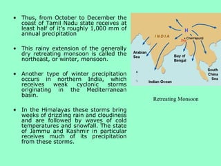
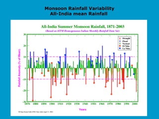
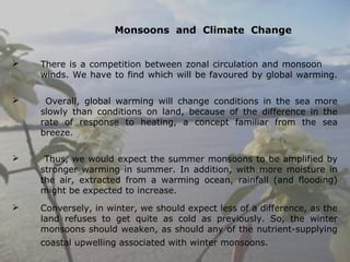
G. Kavitha
TAM/13-19
• India’s climate is dominated by monsoons.
• Monsoons are strong, often violent winds that change
direction with the season.
• The term technically
describes seasonal
reversals of wind direction
caused by temperature
differences between the
land and sea breeze,
creating zones of high and
low pressure over land in
different seasons.
Monsoons occur due to
changes in atmospheric
pressure which are caused by
different rates of heating and
cooling of continents and
oceans.
Monsoons occur every year in
many countries around the
world other than South Asia -
northern Australia, Africa,
South America and the US are
also affected.
The geographical extent of
the global surface
monsoons (the figure
below) can be outlined by
the normalized seasonality
The global surface monsoons contains three kinds of monsoons:
the tropical, subtropical, and temperate-frigid monsoons,
respectively.
The extent of the classical tropical monsoons is surrounded by the
positions of the Inter Tropical Convergence Zone (ITCZ) in
summer and winter, which is the result of the two driving forcings
of the tropical monsoon, the seasonal variation of the planetary
thermal convection and the seasonal variation of the semi-
permanent planetary waves due to the thermal contrast between
ocean and continent. (Li and Zeng, 2000, 2003, 2005).
Surface temperature range that results in the monsoon
Tibetan
plateau
Ocean:
range of
3 to 5°C
Sea surface temperature variations are much smaller than land surface
temperature variations. (Mainly the seasonal cycle)
Monsoon is a term derived form the Arabic word
“Mausim”, meaning season. It was first used by
Arabic navigators to describe the seasonal winds of
the Arabian Sea.
These winds blow from the north-east for one half
of the year and from the south-west for the other
half.
Monsoon winds
blow from cold to
warm regions
because cold air
takes up more space
than warm air
 Being a tropical monsoon country
there are two monsoon seasons.
 The South –West (summer)
monsoon has warm winds blowing
from Indian Ocean. Its span is
June to September, with 75 % of
the annual rainfall in India. It
varies from 10 cm in western
Rajasthan to over 900 cm in
Meghalaya. Summer monsoon
 North- East (winter) monsoon is
characterized by a dry continental
air mass blowing from the vast
Siberian high pressure area from
December to March. The rainfall
includes snowfall during winter
monsoon which is of the order of
1000 km2 in India. This is also known
as Retreating monsoon.
Winter monsoon
• The mountains of southern India split the summer
winds. The western arm of the monsoon is deflected
northwards, by the western Ghats, to Mumbai and then
on to Pakistan.
• The eastern arm travels up through the Bay of Bengal to
Kolkata and Assam, and is deflected north-westwards by
the Himalayas.
• On average, the winds
arrive in southern India
about six weeks before
they arrive in north-west
India.
 Thar desert and adjoining areas of
the northern and central
Indian Subcontinent heats up too
much during summer.
This causes a low pressure area
over the northern and central
Indian subcontinent. To fill up this
void, the moisture-laden winds
from the Indian Ocean rush in to
the subcontinent.
 These winds, rich in moisture, are
drawn towards the Himalayas,
creating winds blowing storm
clouds towards the subcontinent.
The southwest monsoon is
generally expected to begin
around the middle of June and
dies down by September.
a fully illuminated view of the Indian Ocea
region shortly after the onset of the SW
Monsoon.
Indian ocean winds - monsoon
June-August (SW monsoon)
December-March (NE
monsoon)
Onset of South West Monsoon
Retreating Monsoons
( North East Monsoon)
• Much of India experiences
infrequent and relatively
feeble precipitation during the
retreating monsoon.
• An exception to this rule
occurs along the southeastern
coast of India and for some
distance inland.
• When the retreating monsoon
blows from the northeast
across the Bay of Bengal, it
picks up a significant amount
of moisture, which is
subsequently released after
moving back onto the
peninsula.
• .
• Thus, from October to December the
coast of Tamil Nadu state receives at
least half of it’s roughly 1,000 mm of
annual precipitation
• This rainy extension of the generally
dry retreating monsoon is called the
northeast, or winter, monsoon.
• Another type of winter precipitation
occurs in northern India, which
receives weak cyclonic storms
originating in the Mediterranean
basin.
• In the Himalayas these storms bring
weeks of drizzling rain and cloudiness
and are followed by waves of cold
temperatures and snowfall. The state
of Jammu and Kashmir in particular
receives much of its precipitation
from these storms.
Retreating Monsoon
 The heaviest monsoon rainfalls occur where the
winds blow side-on to the hills. The higher the hills
and more moist the air, then the greater the amount
of rainfall.
 These factors give Cherrapunji, in Assam, one of the
highest rainfalls in the world. On average,
Cherrapunji has an annual rainfall total of nearly 11
metres, the maximum monthly amount occurring in
June.
 Mumbai receives about 1.8 metres with the
maximum monthly total in July.
 In comparison, Delhi registers only 64 cm of rainfall
each year with the maximum monthly total occurring
in both July and August.
 At Chennai the pattern of rainfall is different because
the monsoon winds blow along the coast. Here, the
rainfall increases gradually through the summer
months with larger amounts falling in October and
November, owing to tropical cyclones traveling
westwards across the Bay of Bengal.
• The torrential rainstorms often cause
violent landslides and widespread
floods. Entire villages have been
swept away during monsoon rains.
Despite the potential for destruction,
the summer monsoons are
welcomed in India.
• Farmers depend on the rains to
irrigate their land.
• Additionally, a great deal of India’s
electricity is generated by water
power provided by the monsoon
rains.
 Monsoon rainfalls are
unreliable in that the
amount varies
considerably from year to
year. Low rainfalls cause
great problems for
agriculture and water
supplies in general.
 In the Indus river the flood
problem is often made
worse because the
monsoon rainfalls can
coincide with high river
levels in its tributaries,
caused by water from the
melting mountain snows of
the Himalayas
 The monsoon delivers most of India's rainfall and has a key impact on
the economy. Only a third of India's crops grow on irrigated land and
a weak monsoon can wipe out many incomes and shrink demand for
farm equipment and consumer goods.
 The rainfall during the Indian summer monsoon season (June, July
,August and September) show considerable inter-annual and
interseasonal variability.
 Over any part of India, Some years a lot of rainfall occurs causing
flood, while some other years rainfall amount received is much less
causing drought like situations. This year to year variation of rainfall
over a region during monsoon seasons is termed as Interannual
variability of monsoon rainfall.
 This inter-annual variability in the summer monsoon rainfall has a
profound effect on the socioeconomic well being of India. Hence, the
ability to forecast such events became the focus of various
meteorological studies.
Interannual variations of Indian
summer monsoon
Monsoon Rainfall Variability
All-India mean Rainfall
Predictability of the Indian Monsoon
Rainfall
 Short range (1-2 days in advance) and medium (3-10 days in
advance) predictions of rainfall over any region including that over
the Indian region during the monsoon season depend on how well
the initial state of the atmosphere has been defined with large
number of very good quality observed data and the quality dynamic
model used for predictions. The better the initial data, better is the
forecast.
 In the tropical region, it is believed that the predictability of day-
to-day weather patterns is restricted to 3-4 days.
 Observational studies show that the Indian Monsoon’s seasonal
rainfall is linked with several surface boundary conditions like sea
surface temperature (SST) of the east Pacific, Indian ocean ,land
surface temperature, Eurasian and Himalayan snow cover etc.
Prediction of Indian summer monsoon
Since 1988, the Indian Meteorological Department has been issuing
forecast based on 16-parameter power regression and
parametric models.
List of 16 parameters
El Nino (same year) (Nino 1 + 2)
El Nino (previous year) (Nino 1 + 2)
South Indian Ocean SST (Feb. + March)
East Coast India temperature (March)
Arabian Sea SST (Nov. + Dec. + Jan.)
Central India temperature (May)
N H Temperature (Jan. + Feb.)
Darwin pressure tendency (April–Jan)
N H Pressure (Jan. to April)
Southern Oscillation Index (Mar to May)
Indian Ocean Equatorial Pressure (Jan to May)
Europe Pressure Gradient (January)
Argentina pressure (April)
50 hPa East–West Ridge Extension (Jan. + Feb.)
Himalayan Snow Cover (Jan. to Mar.)
Eurasian Snow Cover (Dec.)
Methods of Predicting Indian Monsoon Rainfall
 IMD utilizes statistical method for making seasonal predication of
the Indian monsoon rainfall.
 Studies of historical data sets, over the years, have brought out
several predictors for the monsoon rainfall forecasting.
 The most commonly used statistical technique for seasonal
predication is the linear regression analysis.
 IMD has also started using dynamic model forecasts for proving
southwest monsoon rainfall.
The Hadley Circulation
• The Hadley circulation spans half of the surface area of the
globe, and variability within this system affects the lives of
billions of people.
• Our understanding of this variability is limited to the last century
of instrumental measurements, to the even shorter record of
satellite-derived observations, or to associated modeling studies
aimed at simulating variability in the tropics associated with the
Hadley circulation.
• Only by bringing together climatologists and paleoclimatologists
on the current understanding of the Hadley circulation, by
examining paleoclimatic records that provide evidence of past
variability in this system, and model simulations of expected
future changes, a proper prediction on monsoons can be made.
Monsoon Circulation
Hadley cell
The Hadley cell is a circulation pattern that dominates the tropical
atmosphere, with rising motion near the equator, pole ward flow 10-15
kilometers above the surface, descending motion in the subtropics, and
equator ward flow near the surface. This circulation is intimately related to
the trade winds, tropical rain belts, subtropical deserts and the jet streams.
The Hadley cell carries heat and moisture from the tropics to the northern
and southern mid-latitudes
During Monsoon season, rising limb of Hadley cell is over the Indian continent and the
sinking limb is over the equatorial Indian ocean.
Therefore the monsoons circulation is opposite to conventional Hadley circulation.
Walker circulation
 The Walker circulation is an atmospheric circulation of air
at the equatorial Pacific Ocean, responsible for creating
ocean upwelling off the coasts of Peru and Ecuador.
 This brings nutrient-rich cold water to the surface,
increasing fishing stocks. It was discovered by Jacob
Bjerknes in 1969 and was named after the English physicist
Sir Gilbert Walker who discovered the Southern Oscillation .
 The Walker circulation is caused by the pressure gradient
force that results from a high pressure system over the
eastern pacific ocean, and a low pressure system over
Indonesia.
It is seen at the surface as easterly trade winds which move water
and air warmed by the sun towards the west.
HADLEY circulation is intimately related to the trade
winds, tropical rain belts, subtropical deserts and the
jet streams.
 The trade winds are a pattern of wind that are found in bands
around the Earth's equatorial region. The trade winds are the
prevailing winds in the tropics, blowing from the high-pressure area
in the horse latitudes towards the low-pressure area around the
equator. The trade winds blow predominantly from the northeast in
the northern hemisphere and from the southeast in the southern
hemisphere.
 Jet streams are fast flowing, relatively narrow air currents found in
the atmosphere at around 11 kilometres (36,000 ft) above the
surface of the Earth, just under the tropopause. They form at the
boundaries of adjacent air masses with significant differences in
temperature, such as of the polar region and the warmer air to the
south. The jet stream is mainly found in the Stratosphere.
El Niño and La Niña relation to Indian Monsoons
El Niño and La Niña are defined as sustained sea surface temperature
anomalies of magnitude greater than 0.5°C across the central tropical
Pacific Ocean.
When the condition is met for a period of less than five months, it is
classified as El Niño or La Niña conditions; if the anomaly persists for
five months or longer, it is classified as an El Niño or La Niña episode.
Historically, it has occurred at irregular intervals of 2-7 years and has
usually lasted one or two years.
The first signs of an El Niño are:
 Rise in air pressure over the Indian Ocean, Indonesia, and Australia
 Fall in air pressure over Tahiti and the rest of the central and eastern
Pacific Ocean
 Trade winds in the south Pacific weaken or head east
 Warm air rises near Peru, causing rain in the deserts there
 Warm water spreads from the west Pacific and the Indian Ocean
to the east Pacific. It takes the rain with it, causing rainfall in
normally dry areas and extensive drought in eastern areas.
 For India a continuous and homogeneous record is available
since 1871.
 Monsoon rainfall is increasing (+10 to +12 % per century)
along the west coast, north Andhra Pradesh and in northwest
India. It is decreasing (-6 to –8% per century) over east
Madhya Pradesh and adjoining areas, northeast India and parts
of Gujarat and Kerala.
 A weak monsoon, is a result of a large negative Southern
Oscillation Index (SOI) and El Nino event.
 A strong monsoon, is a result of a large positive SOI and
the absence of El Nino event.
 During the period 1871—1999, 11 of 21 drought years were
El Nino years.
 The periods 1895-1932 and 1965-1987 were characterized by
frequent droughts.
 The periods 1872-1894 and 1933-1964 were practically
drought free
Relationship of EQUINO and ENSO over Indian Monsoon
 Comparison of the evolution of the normal summer monsoon of
2003 with the unanticipated drought of 2002 led to this
investigation of the role of the deep convection in the
atmosphere (deep cloud systems) over the equatorial Indian
Ocean.
 The link of the Indian monsoon to events over the equatorial
Indian Ocean is as important as the well-known link to the
dramatic events over the Pacific (El Niño Southern Oscillation;
ENSO).
 Over the equatorial Indian Ocean, enhancement of deep
convection in the atmosphere over the western part is generally
associated with suppression over the eastern part and vice versa.
This oscillation between these two states, which is reflected in
the pressure gradients and the wind along the equator, the
Equatorial Indian Ocean Oscillation (EQUINOO).
Monsoon depression
A depression that forms within the monsoon trough.
The term is most frequently used to describe weak
cyclonic disturbances that form over the Bay of
Bengal and generally track northwestward over the
Indian subcontinent. These occasionally intensify into
tropical cyclones if they remain over warm ocean
water long enough.
The criteria followed by the Meteorological Department of India to classify
the low pressure systems in the Bay of Bengal and in the Arabian Sea as
adopted by the World Meteorological Organisation (W.M.O.) are:
Types of Disturbances
Associated wind speed in the
Circulation
1. Low Pressure Area
2. Depression
3. Deep Depression
4. Cyclonic Storm
5. Severe Cyclonic Storm
6. Very Severe Cyclonic Storm
7. Super Cyclonic Storm
Less than 17 knots ( < 31 kmph)
17 to 27 knots ( 31 to 49 kmph)
28 to 33 knots ( 50 to 61 kmph)
34 to 47 knots ( 62 to 88 kmph)
48 to 63 knots ( 89 to 118 kmph)
64 to 119 knots ( 119 to 221 kmph)
120 knots and above ( 222 kmph
and above)
1 knot - 1.85 km per hour
Indian Monsoon can be affected by pollution over
Indian Ocean
 A dense brownish haze of microscopic pollutant particles
suspended in air (aerosols) in the Indian Ocean, discovered by an
international team of researchers, could ``affect monsoon
parameters in the long run,'' referred as Atmospheric Brown
cloud.
 Widespread pollution observed recently over an area as large as
the United States in the Indian Ocean including the Bay of Bengal
and the Arabian Sea could affect monsoon in the Indian
subcontinent.
 The extent of the effect, which depends on other factors like how
aerosols react with clouds, is being studied.
Monsoons and Climate Change
 There is a competition between zonal circulation and monsoon
winds. We have to find which will be favoured by global warming.
 Overall, global warming will change conditions in the sea more
slowly than conditions on land, because of the difference in the
rate of response to heating, a concept familiar from the sea
breeze.
 Thus, we would expect the summer monsoons to be amplified by
stronger warming in summer. In addition, with more moisture in
the air, extracted from a warming ocean, rainfall (and flooding)
might be expected to increase.
 Conversely, in winter, we should expect less of a difference, as the
land refuses to get quite as cold as previously. So, the winter
monsoons should weaken, as should any of the nutrient-supplying
coastal upwelling associated with winter monsoons.  
 Changes to India's annual monsoon are
expected to result in severe droughts and
intense flooding in parts of India.
 Scientists predict that by the end of the
century the country will experience a 3 to
5 degree C temperature increase and a
20% rise in all summer monsoon rainfall.
 Climate change studies undertaken so far
reveal that action is essential in order to
prevent long term damage to India's water
cycle.
 The livelihood of a vast population in India
depends on agriculture, forestry, wetlands
and fisheries and land use in these areas is
strongly influenced by water-based
ecosystems that depend on monsoon rains.
Will Climate Change Affect India's Monsoon Season?
Warmer temperature
appear to bring
heavier rainfall
Future changes in monsoon variability
 India is already vulnerable to variations in the
monsoon, both from year-to-year and within the
season.
 One of the key questions in climate change is whether
the remarkable stability of the monsoon rains will
continue, or whether the monsoon will become more
volatile.
 Most models predict a modest increase in interannual
variability but to differing degrees. At the heart of this
are the projections of what will happen to El Nino -
whether it will become stronger and/or more frequent -
since El Nino has dominant influence on monsoon
variability.
 Monsoon is important and scientists are engaged in
understanding the variability of monsoon using observed data
and numerical models.
 Hope that in future we will have more accurate prediction of
Indian monsoon rainfall.

Indian monsoons tam 2013-19

  • 1.
  • 2.
    • India’s climateis dominated by monsoons. • Monsoons are strong, often violent winds that change direction with the season. • The term technically describes seasonal reversals of wind direction caused by temperature differences between the land and sea breeze, creating zones of high and low pressure over land in different seasons.
  • 3.
    Monsoons occur dueto changes in atmospheric pressure which are caused by different rates of heating and cooling of continents and oceans. Monsoons occur every year in many countries around the world other than South Asia - northern Australia, Africa, South America and the US are also affected. The geographical extent of the global surface monsoons (the figure below) can be outlined by the normalized seasonality
  • 4.
    The global surfacemonsoons contains three kinds of monsoons: the tropical, subtropical, and temperate-frigid monsoons, respectively. The extent of the classical tropical monsoons is surrounded by the positions of the Inter Tropical Convergence Zone (ITCZ) in summer and winter, which is the result of the two driving forcings of the tropical monsoon, the seasonal variation of the planetary thermal convection and the seasonal variation of the semi- permanent planetary waves due to the thermal contrast between ocean and continent. (Li and Zeng, 2000, 2003, 2005).
  • 5.
    Surface temperature rangethat results in the monsoon Tibetan plateau Ocean: range of 3 to 5°C Sea surface temperature variations are much smaller than land surface temperature variations. (Mainly the seasonal cycle)
  • 6.
    Monsoon is aterm derived form the Arabic word “Mausim”, meaning season. It was first used by Arabic navigators to describe the seasonal winds of the Arabian Sea. These winds blow from the north-east for one half of the year and from the south-west for the other half. Monsoon winds blow from cold to warm regions because cold air takes up more space than warm air
  • 7.
     Being atropical monsoon country there are two monsoon seasons.  The South –West (summer) monsoon has warm winds blowing from Indian Ocean. Its span is June to September, with 75 % of the annual rainfall in India. It varies from 10 cm in western Rajasthan to over 900 cm in Meghalaya. Summer monsoon  North- East (winter) monsoon is characterized by a dry continental air mass blowing from the vast Siberian high pressure area from December to March. The rainfall includes snowfall during winter monsoon which is of the order of 1000 km2 in India. This is also known as Retreating monsoon. Winter monsoon
  • 8.
    • The mountainsof southern India split the summer winds. The western arm of the monsoon is deflected northwards, by the western Ghats, to Mumbai and then on to Pakistan. • The eastern arm travels up through the Bay of Bengal to Kolkata and Assam, and is deflected north-westwards by the Himalayas. • On average, the winds arrive in southern India about six weeks before they arrive in north-west India.
  • 9.
     Thar desertand adjoining areas of the northern and central Indian Subcontinent heats up too much during summer. This causes a low pressure area over the northern and central Indian subcontinent. To fill up this void, the moisture-laden winds from the Indian Ocean rush in to the subcontinent.  These winds, rich in moisture, are drawn towards the Himalayas, creating winds blowing storm clouds towards the subcontinent. The southwest monsoon is generally expected to begin around the middle of June and dies down by September. a fully illuminated view of the Indian Ocea region shortly after the onset of the SW Monsoon.
  • 10.
    Indian ocean winds- monsoon June-August (SW monsoon) December-March (NE monsoon)
  • 11.
    Onset of SouthWest Monsoon
  • 12.
    Retreating Monsoons ( NorthEast Monsoon) • Much of India experiences infrequent and relatively feeble precipitation during the retreating monsoon. • An exception to this rule occurs along the southeastern coast of India and for some distance inland. • When the retreating monsoon blows from the northeast across the Bay of Bengal, it picks up a significant amount of moisture, which is subsequently released after moving back onto the peninsula. • .
  • 13.
    • Thus, fromOctober to December the coast of Tamil Nadu state receives at least half of it’s roughly 1,000 mm of annual precipitation • This rainy extension of the generally dry retreating monsoon is called the northeast, or winter, monsoon. • Another type of winter precipitation occurs in northern India, which receives weak cyclonic storms originating in the Mediterranean basin. • In the Himalayas these storms bring weeks of drizzling rain and cloudiness and are followed by waves of cold temperatures and snowfall. The state of Jammu and Kashmir in particular receives much of its precipitation from these storms. Retreating Monsoon
  • 14.
     The heaviestmonsoon rainfalls occur where the winds blow side-on to the hills. The higher the hills and more moist the air, then the greater the amount of rainfall.  These factors give Cherrapunji, in Assam, one of the highest rainfalls in the world. On average, Cherrapunji has an annual rainfall total of nearly 11 metres, the maximum monthly amount occurring in June.  Mumbai receives about 1.8 metres with the maximum monthly total in July.  In comparison, Delhi registers only 64 cm of rainfall each year with the maximum monthly total occurring in both July and August.  At Chennai the pattern of rainfall is different because the monsoon winds blow along the coast. Here, the rainfall increases gradually through the summer months with larger amounts falling in October and November, owing to tropical cyclones traveling westwards across the Bay of Bengal.
  • 15.
    • The torrentialrainstorms often cause violent landslides and widespread floods. Entire villages have been swept away during monsoon rains. Despite the potential for destruction, the summer monsoons are welcomed in India. • Farmers depend on the rains to irrigate their land. • Additionally, a great deal of India’s electricity is generated by water power provided by the monsoon rains.
  • 16.
     Monsoon rainfallsare unreliable in that the amount varies considerably from year to year. Low rainfalls cause great problems for agriculture and water supplies in general.  In the Indus river the flood problem is often made worse because the monsoon rainfalls can coincide with high river levels in its tributaries, caused by water from the melting mountain snows of the Himalayas  The monsoon delivers most of India's rainfall and has a key impact on the economy. Only a third of India's crops grow on irrigated land and a weak monsoon can wipe out many incomes and shrink demand for farm equipment and consumer goods.
  • 17.
     The rainfallduring the Indian summer monsoon season (June, July ,August and September) show considerable inter-annual and interseasonal variability.  Over any part of India, Some years a lot of rainfall occurs causing flood, while some other years rainfall amount received is much less causing drought like situations. This year to year variation of rainfall over a region during monsoon seasons is termed as Interannual variability of monsoon rainfall.  This inter-annual variability in the summer monsoon rainfall has a profound effect on the socioeconomic well being of India. Hence, the ability to forecast such events became the focus of various meteorological studies. Interannual variations of Indian summer monsoon
  • 18.
  • 19.
    Predictability of theIndian Monsoon Rainfall  Short range (1-2 days in advance) and medium (3-10 days in advance) predictions of rainfall over any region including that over the Indian region during the monsoon season depend on how well the initial state of the atmosphere has been defined with large number of very good quality observed data and the quality dynamic model used for predictions. The better the initial data, better is the forecast.  In the tropical region, it is believed that the predictability of day- to-day weather patterns is restricted to 3-4 days.  Observational studies show that the Indian Monsoon’s seasonal rainfall is linked with several surface boundary conditions like sea surface temperature (SST) of the east Pacific, Indian ocean ,land surface temperature, Eurasian and Himalayan snow cover etc.
  • 20.
    Prediction of Indiansummer monsoon Since 1988, the Indian Meteorological Department has been issuing forecast based on 16-parameter power regression and parametric models. List of 16 parameters El Nino (same year) (Nino 1 + 2) El Nino (previous year) (Nino 1 + 2) South Indian Ocean SST (Feb. + March) East Coast India temperature (March) Arabian Sea SST (Nov. + Dec. + Jan.) Central India temperature (May) N H Temperature (Jan. + Feb.) Darwin pressure tendency (April–Jan) N H Pressure (Jan. to April) Southern Oscillation Index (Mar to May) Indian Ocean Equatorial Pressure (Jan to May) Europe Pressure Gradient (January) Argentina pressure (April) 50 hPa East–West Ridge Extension (Jan. + Feb.) Himalayan Snow Cover (Jan. to Mar.) Eurasian Snow Cover (Dec.)
  • 21.
    Methods of PredictingIndian Monsoon Rainfall  IMD utilizes statistical method for making seasonal predication of the Indian monsoon rainfall.  Studies of historical data sets, over the years, have brought out several predictors for the monsoon rainfall forecasting.  The most commonly used statistical technique for seasonal predication is the linear regression analysis.  IMD has also started using dynamic model forecasts for proving southwest monsoon rainfall.
  • 22.
    The Hadley Circulation •The Hadley circulation spans half of the surface area of the globe, and variability within this system affects the lives of billions of people. • Our understanding of this variability is limited to the last century of instrumental measurements, to the even shorter record of satellite-derived observations, or to associated modeling studies aimed at simulating variability in the tropics associated with the Hadley circulation. • Only by bringing together climatologists and paleoclimatologists on the current understanding of the Hadley circulation, by examining paleoclimatic records that provide evidence of past variability in this system, and model simulations of expected future changes, a proper prediction on monsoons can be made.
  • 23.
    Monsoon Circulation Hadley cell TheHadley cell is a circulation pattern that dominates the tropical atmosphere, with rising motion near the equator, pole ward flow 10-15 kilometers above the surface, descending motion in the subtropics, and equator ward flow near the surface. This circulation is intimately related to the trade winds, tropical rain belts, subtropical deserts and the jet streams. The Hadley cell carries heat and moisture from the tropics to the northern and southern mid-latitudes
  • 24.
    During Monsoon season,rising limb of Hadley cell is over the Indian continent and the sinking limb is over the equatorial Indian ocean. Therefore the monsoons circulation is opposite to conventional Hadley circulation.
  • 25.
    Walker circulation  TheWalker circulation is an atmospheric circulation of air at the equatorial Pacific Ocean, responsible for creating ocean upwelling off the coasts of Peru and Ecuador.  This brings nutrient-rich cold water to the surface, increasing fishing stocks. It was discovered by Jacob Bjerknes in 1969 and was named after the English physicist Sir Gilbert Walker who discovered the Southern Oscillation .  The Walker circulation is caused by the pressure gradient force that results from a high pressure system over the eastern pacific ocean, and a low pressure system over Indonesia.
  • 26.
    It is seenat the surface as easterly trade winds which move water and air warmed by the sun towards the west.
  • 27.
    HADLEY circulation isintimately related to the trade winds, tropical rain belts, subtropical deserts and the jet streams.  The trade winds are a pattern of wind that are found in bands around the Earth's equatorial region. The trade winds are the prevailing winds in the tropics, blowing from the high-pressure area in the horse latitudes towards the low-pressure area around the equator. The trade winds blow predominantly from the northeast in the northern hemisphere and from the southeast in the southern hemisphere.  Jet streams are fast flowing, relatively narrow air currents found in the atmosphere at around 11 kilometres (36,000 ft) above the surface of the Earth, just under the tropopause. They form at the boundaries of adjacent air masses with significant differences in temperature, such as of the polar region and the warmer air to the south. The jet stream is mainly found in the Stratosphere.
  • 28.
    El Niño andLa Niña relation to Indian Monsoons El Niño and La Niña are defined as sustained sea surface temperature anomalies of magnitude greater than 0.5°C across the central tropical Pacific Ocean. When the condition is met for a period of less than five months, it is classified as El Niño or La Niña conditions; if the anomaly persists for five months or longer, it is classified as an El Niño or La Niña episode. Historically, it has occurred at irregular intervals of 2-7 years and has usually lasted one or two years. The first signs of an El Niño are:  Rise in air pressure over the Indian Ocean, Indonesia, and Australia  Fall in air pressure over Tahiti and the rest of the central and eastern Pacific Ocean  Trade winds in the south Pacific weaken or head east
  • 29.
     Warm airrises near Peru, causing rain in the deserts there  Warm water spreads from the west Pacific and the Indian Ocean to the east Pacific. It takes the rain with it, causing rainfall in normally dry areas and extensive drought in eastern areas.
  • 30.
     For Indiaa continuous and homogeneous record is available since 1871.  Monsoon rainfall is increasing (+10 to +12 % per century) along the west coast, north Andhra Pradesh and in northwest India. It is decreasing (-6 to –8% per century) over east Madhya Pradesh and adjoining areas, northeast India and parts of Gujarat and Kerala.  A weak monsoon, is a result of a large negative Southern Oscillation Index (SOI) and El Nino event.  A strong monsoon, is a result of a large positive SOI and the absence of El Nino event.  During the period 1871—1999, 11 of 21 drought years were El Nino years.  The periods 1895-1932 and 1965-1987 were characterized by frequent droughts.  The periods 1872-1894 and 1933-1964 were practically drought free
  • 31.
    Relationship of EQUINOand ENSO over Indian Monsoon  Comparison of the evolution of the normal summer monsoon of 2003 with the unanticipated drought of 2002 led to this investigation of the role of the deep convection in the atmosphere (deep cloud systems) over the equatorial Indian Ocean.  The link of the Indian monsoon to events over the equatorial Indian Ocean is as important as the well-known link to the dramatic events over the Pacific (El Niño Southern Oscillation; ENSO).  Over the equatorial Indian Ocean, enhancement of deep convection in the atmosphere over the western part is generally associated with suppression over the eastern part and vice versa. This oscillation between these two states, which is reflected in the pressure gradients and the wind along the equator, the Equatorial Indian Ocean Oscillation (EQUINOO).
  • 32.
    Monsoon depression A depressionthat forms within the monsoon trough. The term is most frequently used to describe weak cyclonic disturbances that form over the Bay of Bengal and generally track northwestward over the Indian subcontinent. These occasionally intensify into tropical cyclones if they remain over warm ocean water long enough.
  • 33.
    The criteria followedby the Meteorological Department of India to classify the low pressure systems in the Bay of Bengal and in the Arabian Sea as adopted by the World Meteorological Organisation (W.M.O.) are: Types of Disturbances Associated wind speed in the Circulation 1. Low Pressure Area 2. Depression 3. Deep Depression 4. Cyclonic Storm 5. Severe Cyclonic Storm 6. Very Severe Cyclonic Storm 7. Super Cyclonic Storm Less than 17 knots ( < 31 kmph) 17 to 27 knots ( 31 to 49 kmph) 28 to 33 knots ( 50 to 61 kmph) 34 to 47 knots ( 62 to 88 kmph) 48 to 63 knots ( 89 to 118 kmph) 64 to 119 knots ( 119 to 221 kmph) 120 knots and above ( 222 kmph and above) 1 knot - 1.85 km per hour
  • 34.
    Indian Monsoon canbe affected by pollution over Indian Ocean  A dense brownish haze of microscopic pollutant particles suspended in air (aerosols) in the Indian Ocean, discovered by an international team of researchers, could ``affect monsoon parameters in the long run,'' referred as Atmospheric Brown cloud.  Widespread pollution observed recently over an area as large as the United States in the Indian Ocean including the Bay of Bengal and the Arabian Sea could affect monsoon in the Indian subcontinent.  The extent of the effect, which depends on other factors like how aerosols react with clouds, is being studied. Indian Monsoon can be affected by pollution over Indian Ocean  A dense brownish haze of microscopic pollutant particles suspended in air (aerosols) in the Indian Ocean, discovered by an international team of researchers, could ``affect monsoon parameters in the long run,'' referred as Atmospheric Brown cloud.  Widespread pollution observed recently over an area as large as the United States in the Indian Ocean including the Bay of Bengal and the Arabian Sea could affect monsoon in the Indian subcontinent.  The extent of the effect, which depends on other factors like how aerosols react with clouds, is being studied.
  • 35.
    Monsoons and ClimateChange  There is a competition between zonal circulation and monsoon winds. We have to find which will be favoured by global warming.  Overall, global warming will change conditions in the sea more slowly than conditions on land, because of the difference in the rate of response to heating, a concept familiar from the sea breeze.  Thus, we would expect the summer monsoons to be amplified by stronger warming in summer. In addition, with more moisture in the air, extracted from a warming ocean, rainfall (and flooding) might be expected to increase.  Conversely, in winter, we should expect less of a difference, as the land refuses to get quite as cold as previously. So, the winter monsoons should weaken, as should any of the nutrient-supplying coastal upwelling associated with winter monsoons.  
  • 36.
     Changes toIndia's annual monsoon are expected to result in severe droughts and intense flooding in parts of India.  Scientists predict that by the end of the century the country will experience a 3 to 5 degree C temperature increase and a 20% rise in all summer monsoon rainfall.  Climate change studies undertaken so far reveal that action is essential in order to prevent long term damage to India's water cycle.  The livelihood of a vast population in India depends on agriculture, forestry, wetlands and fisheries and land use in these areas is strongly influenced by water-based ecosystems that depend on monsoon rains. Will Climate Change Affect India's Monsoon Season? Warmer temperature appear to bring heavier rainfall
  • 37.
    Future changes inmonsoon variability  India is already vulnerable to variations in the monsoon, both from year-to-year and within the season.  One of the key questions in climate change is whether the remarkable stability of the monsoon rains will continue, or whether the monsoon will become more volatile.  Most models predict a modest increase in interannual variability but to differing degrees. At the heart of this are the projections of what will happen to El Nino - whether it will become stronger and/or more frequent - since El Nino has dominant influence on monsoon variability.  Monsoon is important and scientists are engaged in understanding the variability of monsoon using observed data and numerical models.  Hope that in future we will have more accurate prediction of Indian monsoon rainfall.