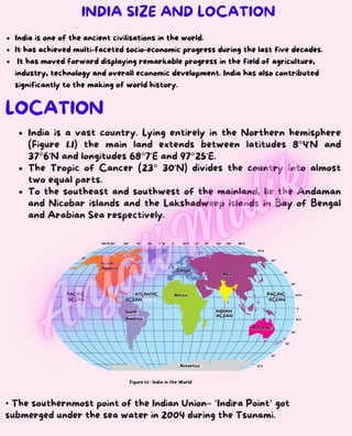
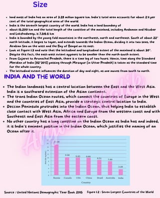
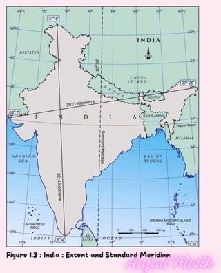
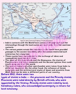
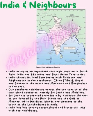
India is a vast country. Lying entirely in the Northern hemisphere
(Figure 1.1) the main land extends between latitudes 8°4'N and
37°6'N and longitudes 68°7'E and 97°25'E.
The Tropic of Cancer (23° 30'N) divides the country into almost
two equal parts.
To the southeast and southwest of the mainland, lie the Andaman
and Nicobar islands and the Lakshadweep islands in Bay of Bengal
and Arabian Sea respectively.
LOCATION
Figure 1.1 : India in the World
• The southernmost point of the Indian Union– ‘Indira Point’ got
submerged under the sea water in 2004 during the Tsunami.
180°W 150° 120° 90° 60° 30°W 0
°
30°E 60° 90° 120° 150° 180°E
75°S
75°N
60°
60°
45°
45°
30°
30°
0
°
15°N
15°S
PACIFIC
OCEAN
North
America
ATLANTIC
OCEAN
South
America
Africa
Europe
Antartica
INDIAN
OCEAN
Asia
Australia
PACIFIC
OCEAN
INDIA SIZE AND LOCATION
India is one of the ancient civilisations in the world.
It has achieved multi-faceted socio-economic progress during the last five decades.
It has moved forward displaying remarkable progress in the field of agriculture,
industry, technology and overall economic development. India has also contributed
significantly to the making of world history.
Figure 1.2 : Seven Largest Countries of the World
The Indian landmass has a central location between the East and the West Asia.
India is a southward extension of the Asian continent.
The trans Indian Ocean routes, which connect the countries of Europe in the West
and the countries of East Asia, provide a strategic central location to India.
Deccan Peninsula protrudes into the Indian Ocean, thus helping India to establish
close contact with West Asia, Africa and Europe from the western coast and with
Southeast and East Asia from the eastern coast.
No other country has a long coastline on the Indian Ocean as India has and indeed,
it is India’s eminent position in the Indian Ocean, which justifies the naming of an
Ocean after it.
INDIA AND THE WORLD
Source : United Nations Demographic Year Book 2015
land mass of India has an area of 3.28 million square km. India’s total area accounts for about 2.4 per
cent of the total geographical area of the world.
India is the seventh largest country of the world. India has a land boundary of
about 15,200 km and the total length of the coastline of the mainland, including Andaman and Nicobar
and Lakshadweep, is 7,516.6 km
India is bounded by the young fold mountains in the northwest, north and northeast. South of about 22°
north latitude, it begins to taper, and extends towards the Indian Ocean, dividing it into two seas, the
Arabian Sea on the west and the Bay of Bengal on its east.
Look at Figure 1.3 and note that the latitudinal and longitudinal extent of the mainland is about 30°.
Despite this fact, the east-west extent appears to be smaller than the north-south extent.
From Gujarat to Arunachal Pradesh, there is a time lag of two hours. Hence, time along the Standard
Meridian of India (82°30'E) passing through Mirzapur (in Uttar Pradesh) is taken as the standard time
for the whole country.
The latitudinal extent influences the duration of day and night, as one moves from south to north.
Size
Figure 1.3 : India : Extent and Standard Meridian
Figure 1.4 : India on International Highway of Trade and Commerce
Before 1947, there were two
types of states in India — the provinces and the Princely states.
Provinces were ruled directly by British officials, who were
appointed by the Viceroy. Princely states were ruled by local,
hereditary rulers, who acknowledged sovereignity in return for
local autonomy.
India’s contacts with the World have continued through ages but her
relationships through the land routes are much older than her maritime
contacts.
The various passes across the mountains in the north have provided
passages to the ancient travellers, while the oceans restricted such
interaction for a long time.
These routes have contributed in the exchange of ideas and
commodities since ancient times.
The ideas of the Upanishads and the Ramayana, the stories of
Panchtantra, the Indian numerals and the decimal system thus could
reach many parts of the world.
The spices, muslin and other merchandise were taken from India to
different countries. On the other hand, the influence of Greek
sculpture, and the architectural styles of dome and minarets from
West Asia can be seen in different parts of our country.
Figure 1.5 : India and Adjacent Countries
India occupies an important strategic position in South
Asia. India has 28 states and Eight Union Territories
India shares its land boundaries with Pakistan and
Afghanistan in the northwest, China (Tibet), Nepal
and Bhutan in the north and Myanmar and Bangladesh
in the east.
Our southern neighbours across the sea consist of the
two island countries, namely Sri Lanka and Maldives.
Sri Lanka is separated from India by a narrow channel
of sea formed by the Palk Strait and the Gulf of
Mannar, while Maldives Islands are situated to the
south of the Lakshadweep Islands.
India has had strong geographical and historical links
with her neighbours.
India & Neighbours
1.Choose the right answer from the four alternatives given below.
(i)The Tropic of Cancer does not pass through
(a) Rajasthan (c) Chhattisgarh
(b) Odisha (d) Tripura
(ii)The easternmost longitude of India is
(a)97° 25' E(c) 77° 6' E
(b)68° 7' E(d) 82° 32' E
(iii)Uttarakhand, Uttar Pradesh, Bihar, West Bengal and Sikkim have
common frontiers with
(a) China (c) Nepal
(b) Bhutan (d) Myanmar
(iv)If you intend to visit Kavarati during your summer vacations, which
one of the following Union Territories of India you will be going to
(a)Puducherry(c)Andaman and Nicobar
(b)Lakshadweep(d)Daman and Diu
(v)My friend hails from a country which does not share land
boundary with India. Identify the country.
(a)Bhutan(c) Bangladesh
(b)Tajikistan(d) Nepal
2Answer the following questions briefly.
(i)Name the group of islands lying in the Arabian Sea.
(ii)Name the countries which are larger than India.
(iii)Which island group of India lies to its south-east?
(iv)Which island countries are our southern neighbours?
3The sun rises two hours earlier in Arunachal Pradesh as compared
to Gujarat in the west but the watches show the same time. How
does this happen?
4The central location of India at the head of the Indian Ocean is
considered of great significance. Why?
EXERCISE

Class 9, Chapter-1 (India:Size & Location)

  • 1.
    India is avast country. Lying entirely in the Northern hemisphere (Figure 1.1) the main land extends between latitudes 8°4'N and 37°6'N and longitudes 68°7'E and 97°25'E. The Tropic of Cancer (23° 30'N) divides the country into almost two equal parts. To the southeast and southwest of the mainland, lie the Andaman and Nicobar islands and the Lakshadweep islands in Bay of Bengal and Arabian Sea respectively. LOCATION Figure 1.1 : India in the World • The southernmost point of the Indian Union– ‘Indira Point’ got submerged under the sea water in 2004 during the Tsunami. 180°W 150° 120° 90° 60° 30°W 0 ° 30°E 60° 90° 120° 150° 180°E 75°S 75°N 60° 60° 45° 45° 30° 30° 0 ° 15°N 15°S PACIFIC OCEAN North America ATLANTIC OCEAN South America Africa Europe Antartica INDIAN OCEAN Asia Australia PACIFIC OCEAN INDIA SIZE AND LOCATION India is one of the ancient civilisations in the world. It has achieved multi-faceted socio-economic progress during the last five decades. It has moved forward displaying remarkable progress in the field of agriculture, industry, technology and overall economic development. India has also contributed significantly to the making of world history.
  • 2.
    Figure 1.2 :Seven Largest Countries of the World The Indian landmass has a central location between the East and the West Asia. India is a southward extension of the Asian continent. The trans Indian Ocean routes, which connect the countries of Europe in the West and the countries of East Asia, provide a strategic central location to India. Deccan Peninsula protrudes into the Indian Ocean, thus helping India to establish close contact with West Asia, Africa and Europe from the western coast and with Southeast and East Asia from the eastern coast. No other country has a long coastline on the Indian Ocean as India has and indeed, it is India’s eminent position in the Indian Ocean, which justifies the naming of an Ocean after it. INDIA AND THE WORLD Source : United Nations Demographic Year Book 2015 land mass of India has an area of 3.28 million square km. India’s total area accounts for about 2.4 per cent of the total geographical area of the world. India is the seventh largest country of the world. India has a land boundary of about 15,200 km and the total length of the coastline of the mainland, including Andaman and Nicobar and Lakshadweep, is 7,516.6 km India is bounded by the young fold mountains in the northwest, north and northeast. South of about 22° north latitude, it begins to taper, and extends towards the Indian Ocean, dividing it into two seas, the Arabian Sea on the west and the Bay of Bengal on its east. Look at Figure 1.3 and note that the latitudinal and longitudinal extent of the mainland is about 30°. Despite this fact, the east-west extent appears to be smaller than the north-south extent. From Gujarat to Arunachal Pradesh, there is a time lag of two hours. Hence, time along the Standard Meridian of India (82°30'E) passing through Mirzapur (in Uttar Pradesh) is taken as the standard time for the whole country. The latitudinal extent influences the duration of day and night, as one moves from south to north. Size
  • 3.
    Figure 1.3 :India : Extent and Standard Meridian
  • 4.
    Figure 1.4 :India on International Highway of Trade and Commerce Before 1947, there were two types of states in India — the provinces and the Princely states. Provinces were ruled directly by British officials, who were appointed by the Viceroy. Princely states were ruled by local, hereditary rulers, who acknowledged sovereignity in return for local autonomy. India’s contacts with the World have continued through ages but her relationships through the land routes are much older than her maritime contacts. The various passes across the mountains in the north have provided passages to the ancient travellers, while the oceans restricted such interaction for a long time. These routes have contributed in the exchange of ideas and commodities since ancient times. The ideas of the Upanishads and the Ramayana, the stories of Panchtantra, the Indian numerals and the decimal system thus could reach many parts of the world. The spices, muslin and other merchandise were taken from India to different countries. On the other hand, the influence of Greek sculpture, and the architectural styles of dome and minarets from West Asia can be seen in different parts of our country.
  • 5.
    Figure 1.5 :India and Adjacent Countries India occupies an important strategic position in South Asia. India has 28 states and Eight Union Territories India shares its land boundaries with Pakistan and Afghanistan in the northwest, China (Tibet), Nepal and Bhutan in the north and Myanmar and Bangladesh in the east. Our southern neighbours across the sea consist of the two island countries, namely Sri Lanka and Maldives. Sri Lanka is separated from India by a narrow channel of sea formed by the Palk Strait and the Gulf of Mannar, while Maldives Islands are situated to the south of the Lakshadweep Islands. India has had strong geographical and historical links with her neighbours. India & Neighbours
  • 6.
    1.Choose the rightanswer from the four alternatives given below. (i)The Tropic of Cancer does not pass through (a) Rajasthan (c) Chhattisgarh (b) Odisha (d) Tripura (ii)The easternmost longitude of India is (a)97° 25' E(c) 77° 6' E (b)68° 7' E(d) 82° 32' E (iii)Uttarakhand, Uttar Pradesh, Bihar, West Bengal and Sikkim have common frontiers with (a) China (c) Nepal (b) Bhutan (d) Myanmar (iv)If you intend to visit Kavarati during your summer vacations, which one of the following Union Territories of India you will be going to (a)Puducherry(c)Andaman and Nicobar (b)Lakshadweep(d)Daman and Diu (v)My friend hails from a country which does not share land boundary with India. Identify the country. (a)Bhutan(c) Bangladesh (b)Tajikistan(d) Nepal 2Answer the following questions briefly. (i)Name the group of islands lying in the Arabian Sea. (ii)Name the countries which are larger than India. (iii)Which island group of India lies to its south-east? (iv)Which island countries are our southern neighbours? 3The sun rises two hours earlier in Arunachal Pradesh as compared to Gujarat in the west but the watches show the same time. How does this happen? 4The central location of India at the head of the Indian Ocean is considered of great significance. Why? EXERCISE