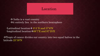
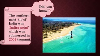
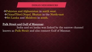
Geography chapter 1 India size and
location
SIZE
INDE
X
LOCATION
Introduction
 India is a ancient developed
countries.
 India is the seventh largest
 it has shown a massive
economic development in those
years very well
Location
 India is a vast country
it entirely lies in the northern hemisphere
-Latitudinal location 8˚4’ N and 37˚6’N
-longitudinal location68˚7’E and 97˚25’E
Tropic of cancer divides our country into two equal halves in the
latitude 23˚30’N
The southern
most tip of
India was
‘Indira point’
which was
submerged in
2004 tsunami.
Did you
know!!
SIZE
Total land mass 3.28 million square km
India’s total land in globe is about 2.4‰.
Land boundary 15,200km
Coastal boundary(including Andaman and Nicobar and
Lakshadweep)7,516.6km
From Gujarat to Arunachal Pradesh there is lag of 2 hours.
Time along the standard meridian of India (82˚30’E) passes
through Mirzapur is taken as standard time.
INDIA AND THE
WORLD
Central location between east and west Asia. Indian ocean
routes connect Europe in the west and countries of east
Asia provide central location to India.
Deccan peninsula protrudes Indian ocean thus contact with
west Africa and Europe(western coast)South east and east
Asia(eastern coast).
These routes have contributed in the exchange of Indian
commodities since ancient times.
idea of:
 Upanishads
Ramayana
 Panchatantra
Indian numerals and decimals.
They also shared spices, muslin and other merchandise from India
to other country.
The Indian numerals is also known as ‘Sindu-Arabic system’
because to take these ideas the Arabians helped Indians
INDIA’S NEIGHBOURS
Pakistan and Afghanistan in north west.
China(Tibet),Nepal, Bhutan in the North-east
Sri Lanka and Maldives in south.
Palk Strait and Gulf of Mannnar.
India and sri lanka was linked by the narrow channel
known as Palk Strait and also connect Gulf of Mannar.
Presentation by V.
Vidhya Lakshmi
Asian Christian
Academy, Hosur
Tamilnadu

India size and location

  • 1.
    Geography chapter 1India size and location
  • 2.
  • 3.
    Introduction  India isa ancient developed countries.  India is the seventh largest  it has shown a massive economic development in those years very well
  • 4.
    Location  India isa vast country it entirely lies in the northern hemisphere -Latitudinal location 8˚4’ N and 37˚6’N -longitudinal location68˚7’E and 97˚25’E Tropic of cancer divides our country into two equal halves in the latitude 23˚30’N
  • 5.
    The southern most tipof India was ‘Indira point’ which was submerged in 2004 tsunami. Did you know!!
  • 6.
    SIZE Total land mass3.28 million square km India’s total land in globe is about 2.4‰. Land boundary 15,200km Coastal boundary(including Andaman and Nicobar and Lakshadweep)7,516.6km From Gujarat to Arunachal Pradesh there is lag of 2 hours. Time along the standard meridian of India (82˚30’E) passes through Mirzapur is taken as standard time.
  • 7.
    INDIA AND THE WORLD Centrallocation between east and west Asia. Indian ocean routes connect Europe in the west and countries of east Asia provide central location to India. Deccan peninsula protrudes Indian ocean thus contact with west Africa and Europe(western coast)South east and east Asia(eastern coast).
  • 8.
    These routes havecontributed in the exchange of Indian commodities since ancient times. idea of:  Upanishads Ramayana  Panchatantra Indian numerals and decimals. They also shared spices, muslin and other merchandise from India to other country. The Indian numerals is also known as ‘Sindu-Arabic system’ because to take these ideas the Arabians helped Indians
  • 9.
    INDIA’S NEIGHBOURS Pakistan andAfghanistan in north west. China(Tibet),Nepal, Bhutan in the North-east Sri Lanka and Maldives in south. Palk Strait and Gulf of Mannnar. India and sri lanka was linked by the narrow channel known as Palk Strait and also connect Gulf of Mannar.
  • 10.
    Presentation by V. VidhyaLakshmi Asian Christian Academy, Hosur Tamilnadu