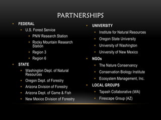
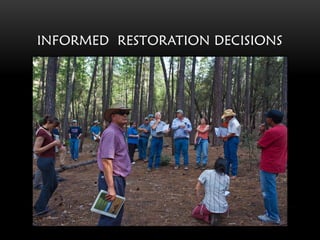
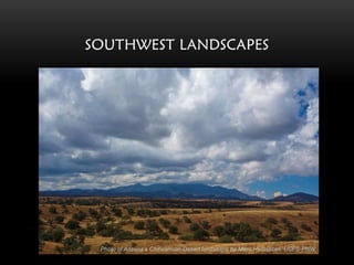
MAKING INFORMED WILDLAND
                  RESTORATION DECISIONS IN THE
                   NORTHWEST AND SOUTHWEST


           INTEGRATED LANDSCAPE ASSESSMENT PROJECT
                                               www.oregonstate.edu/inr/ilap

Presentation by
Janine Salwasser, Project Coordinator
Agriculture, Food, Nutrition and Natural Resources R&D Round Table

 March 15, 2011
LANDSCAPES


Photo of Blue Mountains landscape in Eastern Oregon by Miles Hemstrom, USFS-PNW
PARTNERSHIPS
•   FEDERAL                             •   UNIVERSITY
    • U.S. Forest Service
                                            • Institute for Natural Resources
         • PNW Research Station
                                            • Oregon State University
         • Rocky Mountain Research
           Station                          • University of Washington
         • Region 3                         • University of New Mexico
         • Region 6                     •   NGOs
•   STATE                                   • The Nature Conservancy
    • Washington Dept. of Natural           • Conservation Biology Institute
      Resources
                                            • Ecosystem Management, Inc.
    • Oregon Dept. of Forestry
    • Arizona Division of Forestry      •   LOCAL GROUPS
    • Arizona Dept. of Game & Fish          • Tapash Collaborative (WA)
    • New Mexico Division of Forestry       • Firescape Group (AZ)
JOBS


Photo of some ILAP team members on flanks of Mt. Hood, Oregon by Miles Hemstrom, USFS-PNW
INFORMED RESTORATION DECISIONS
WHAT ARE CURRENT AND FUTURE
TRENDS IN VEGETATION CONDITIONS?
NORTHWEST LANDSCAPES
SOUTHWEST LANDSCAPES


 Photo of Arizona’s Chihuahuan Desert landscape by Miles Hemstrom, USFS-PNW
WILL MANAGEMENT MAKE A DIFFERENCE
        ON THE LANDSCAPE?
ARE WILDLIFE HABITATS IMPROVED?


      Photo of Northern Spotted Owls in Oregon’s Cascade region by James Johnston, INR
IS WILDFIRE RISK REDUCED?


Photo of Ponderosa Pine forest with high wildfire risk by Miles Hemstrom, PNW Research Station
ARE REVENUES GENERATED?


        Photo of Lumber Mill in Seneca, Oregon by James Johnston, INR
ARE RURAL COMMUNITIES ENHANCED?


 Photo of Simpson Lumber mill in Shelton, Washington
 Wikipedia Commons - http://commons.wikimedia.org/wiki/File:Simpson_lumber-Shelton_Washington.jpg
CAN WE HELP MAKE MORE INFORMED
     RESTORATION DECISIONS?
TEAM DYNAMICS


Science Delivery   Knowledge Discovery   Decision Support
SCIENCE DELIVERY

   Existing
vegetation data


                     Starting
   Potential
  vegetation        vegetation
                    conditions   State and Transition Models

  Ownership
  Allocations


                                             Future
                                           vegetation
 Watershed
 boundaries
                                           conditions
   HUC 5
WALL – TO – WALL VEGETATION DATA
            For SW region
KNOWLEDGE DISCOVERY
                                                           Economic     Wildlife
                                                           potential    habitats
    Incorporate
    management
     scenarios                  Fuels

                                Wildlife habitat

                                Fuel treatment economics

                                Community economics
State and Transition
      Models                                               Community   Wildfire-fuel
                                                           economics    hazards

                       Interpretations
COMMUNITY IMPACT SCORES
                for NW watersheds


DISTRESS        CAPACITY              POLICY
                                     IMPACTS


                Draft outputs       DRAFT
DECISION SUPPORT
Wildfire-fuel    Wildlife
 hazards         habitat
                                 User
                                Inputs


                              Decision
                              Support

Community            Fuel
Economics         Treatment
                  Economics
WATERSHED PRIORITIES


                Improved Wildlife Habitats
                Positive Community Economics
                Positive Treatment Revenues
                Decreased Fuel Reductions
                Increased Water Supply
IMPACTS

• Informing Forest Planning
• Supporting 2015 Statewide
  Assessments
• Assisting Collaborative Forest
  Landscape Restoration Groups
• Informing Landscape
  Conservation Collaboratives
• Supporting Recovery Planning
• Evaluating Proposed Policies
PROJECT PRODUCTS & ACCESS


    www.oregonexplorer.info
                              10/18/10
Vision for the Future of ILAP


Multi-angle Imaging SpectroRadiometer image of the West by NASA/GSFC/LaRC/JPL, MISR Team
http://eosweb.larc.nasa.gov/HPDOCS/misr/misr_html/usa_canada_west.html
For more information about the
              Integrated Landscape Assessment
              Project,
              please contact:


Janine Salwasser, project coordinator
janine.salwasser@oregonstate.edu
541.737.9921

Miles Hemstrom, Forest Service project leader
mhemstrom@fs.fed.us
503.808.2006
                                                 www.oregonstate.edu/inr/ilap
Lisa Gaines, project Co-Principal Investigator
Lisa.gaines@oregonstate.edu
541-737-1976

Integrated Landscape Assessment Project

  • 1.
    MAKING INFORMED WILDLAND RESTORATION DECISIONS IN THE NORTHWEST AND SOUTHWEST INTEGRATED LANDSCAPE ASSESSMENT PROJECT www.oregonstate.edu/inr/ilap Presentation by Janine Salwasser, Project Coordinator Agriculture, Food, Nutrition and Natural Resources R&D Round Table March 15, 2011
  • 2.
    LANDSCAPES Photo of BlueMountains landscape in Eastern Oregon by Miles Hemstrom, USFS-PNW
  • 3.
    PARTNERSHIPS • FEDERAL • UNIVERSITY • U.S. Forest Service • Institute for Natural Resources • PNW Research Station • Oregon State University • Rocky Mountain Research Station • University of Washington • Region 3 • University of New Mexico • Region 6 • NGOs • STATE • The Nature Conservancy • Washington Dept. of Natural • Conservation Biology Institute Resources • Ecosystem Management, Inc. • Oregon Dept. of Forestry • Arizona Division of Forestry • LOCAL GROUPS • Arizona Dept. of Game & Fish • Tapash Collaborative (WA) • New Mexico Division of Forestry • Firescape Group (AZ)
  • 4.
    JOBS Photo of someILAP team members on flanks of Mt. Hood, Oregon by Miles Hemstrom, USFS-PNW
  • 5.
  • 6.
    WHAT ARE CURRENTAND FUTURE TRENDS IN VEGETATION CONDITIONS?
  • 7.
  • 8.
    SOUTHWEST LANDSCAPES Photoof Arizona’s Chihuahuan Desert landscape by Miles Hemstrom, USFS-PNW
  • 9.
    WILL MANAGEMENT MAKEA DIFFERENCE ON THE LANDSCAPE?
  • 10.
    ARE WILDLIFE HABITATSIMPROVED? Photo of Northern Spotted Owls in Oregon’s Cascade region by James Johnston, INR
  • 11.
    IS WILDFIRE RISKREDUCED? Photo of Ponderosa Pine forest with high wildfire risk by Miles Hemstrom, PNW Research Station
  • 12.
    ARE REVENUES GENERATED? Photo of Lumber Mill in Seneca, Oregon by James Johnston, INR
  • 13.
    ARE RURAL COMMUNITIESENHANCED? Photo of Simpson Lumber mill in Shelton, Washington Wikipedia Commons - http://commons.wikimedia.org/wiki/File:Simpson_lumber-Shelton_Washington.jpg
  • 14.
    CAN WE HELPMAKE MORE INFORMED RESTORATION DECISIONS?
  • 15.
    TEAM DYNAMICS Science Delivery Knowledge Discovery Decision Support
  • 16.
    SCIENCE DELIVERY Existing vegetation data Starting Potential vegetation vegetation conditions State and Transition Models Ownership Allocations Future vegetation Watershed boundaries conditions HUC 5
  • 17.
    WALL – TO– WALL VEGETATION DATA For SW region
  • 18.
    KNOWLEDGE DISCOVERY Economic Wildlife potential habitats Incorporate management scenarios Fuels Wildlife habitat Fuel treatment economics Community economics State and Transition Models Community Wildfire-fuel economics hazards Interpretations
  • 19.
    COMMUNITY IMPACT SCORES for NW watersheds DISTRESS CAPACITY POLICY IMPACTS Draft outputs DRAFT
  • 20.
    DECISION SUPPORT Wildfire-fuel Wildlife hazards habitat User Inputs Decision Support Community Fuel Economics Treatment Economics
  • 21.
    WATERSHED PRIORITIES Improved Wildlife Habitats Positive Community Economics Positive Treatment Revenues Decreased Fuel Reductions Increased Water Supply
  • 22.
    IMPACTS • Informing ForestPlanning • Supporting 2015 Statewide Assessments • Assisting Collaborative Forest Landscape Restoration Groups • Informing Landscape Conservation Collaboratives • Supporting Recovery Planning • Evaluating Proposed Policies
  • 23.
    PROJECT PRODUCTS &ACCESS www.oregonexplorer.info 10/18/10
  • 24.
    Vision for theFuture of ILAP Multi-angle Imaging SpectroRadiometer image of the West by NASA/GSFC/LaRC/JPL, MISR Team http://eosweb.larc.nasa.gov/HPDOCS/misr/misr_html/usa_canada_west.html
  • 25.
    For more informationabout the Integrated Landscape Assessment Project, please contact: Janine Salwasser, project coordinator janine.salwasser@oregonstate.edu 541.737.9921 Miles Hemstrom, Forest Service project leader mhemstrom@fs.fed.us 503.808.2006 www.oregonstate.edu/inr/ilap Lisa Gaines, project Co-Principal Investigator Lisa.gaines@oregonstate.edu 541-737-1976