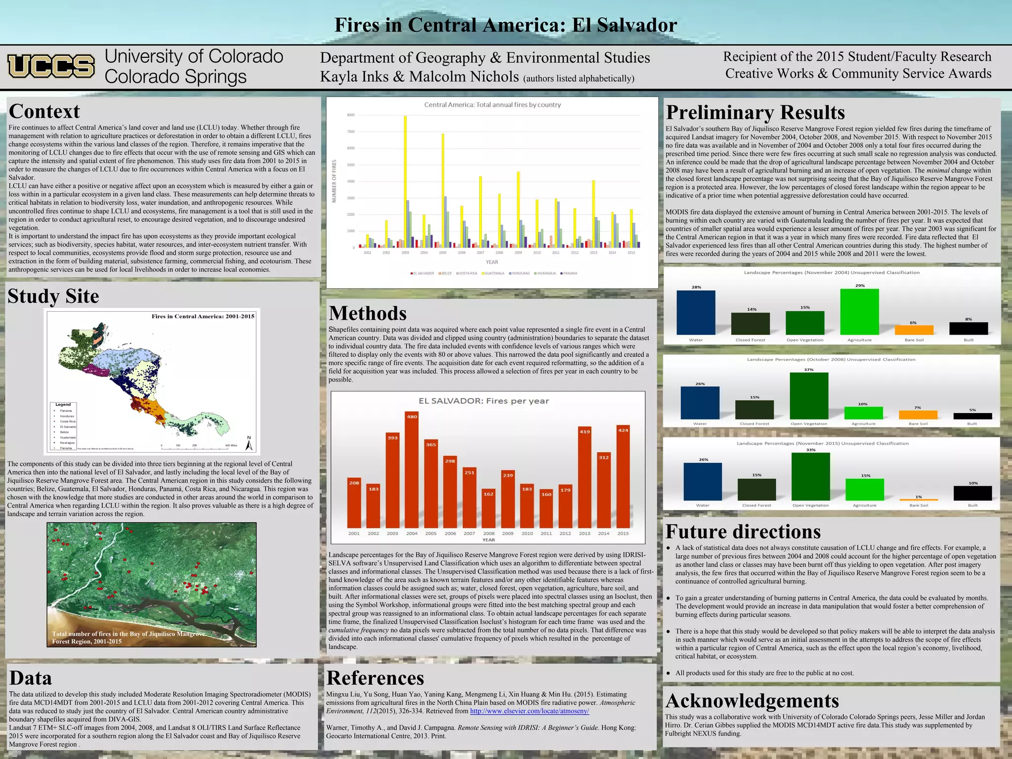
SlideShare a Scribd company logo
Fires in Central America: El Salvador
Context
Fire continues to affect Central America’s land cover and land use (LCLU) today. Whether through fire
management with relation to agriculture practices or deforestation in order to obtain a different LCLU, fires
change ecosystems within the various land classes of the region. Therefore, it remains imperative that the
monitoring of LCLU changes due to fire effects that occur with the use of remote sensing and GIS which can
capture the intensity and spatial extent of fire phenomenon. This study uses fire data from 2001 to 2015 in
order to measure the changes of LCLU due to fire occurrences within Central America with a focus on El
Salvador.
LCLU can have either a positive or negative affect upon an ecosystem which is measured by either a gain or
loss within in a particular ecosystem in a given land class. These measurements can help determine threats to
critical habitats in relation to biodiversity loss, water inundation, and anthropogenic resources. While
uncontrolled fires continue to shape LCLU and ecosystems, fire management is a tool that is still used in the
region in order to conduct agricultural reset, to encourage desired vegetation, and to discourage undesired
vegetation.
It is important to understand the impact fire has upon ecosystems as they provide important ecological
services; such as biodiversity, species habitat, water resources, and inter-ecosystem nutrient transfer. With
respect to local communities, ecosystems provide flood and storm surge protection, resource use and
extraction in the form of building material, subsistence farming, commercial fishing, and ecotourism. These
anthropogenic services can be used for local livelihoods in order to increase local economies.
Data
The data utilized to develop this study included Moderate Resolution Imaging Spectroradiometer (MODIS)
fire data MCD14MDT from 2001-2015 and LCLU data from 2001-2012 covering Central America. This
data was reduced to study just the country of El Salvador. Central American country administrative
boundary shapefiles acquired from DIVA-GIS.
Landsat 7 ETM+ SLC-off images from 2004, 2008, and Landsat 8 OLI/TIRS Land Surface Reflectance
2015 were incorporated for a southern region along the El Salvador coast and Bay of Jiquilisco Reserve
Mangrove Forest region .
Preliminary Results
El Salvador’s southern Bay of Jiquilisco Reserve Mangrove Forest region yielded few fires during the timeframe of
acquired Landsat imagery for November 2004, October 2008, and November 2015. With respect to November 2015
no fire data was available and in November of 2004 and October 2008 only a total four fires occurred during the
prescribed time period. Since there were few fires occurring at such small scale no regression analysis was conducted.
An inference could be made that the drop of agricultural landscape percentage between November 2004 and October
2008 may have been a result of agricultural burning and an increase of open vegetation. The minimal change within
the closed forest landscape percentage was not surprising seeing that the Bay of Jiquilisco Reserve Mangrove Forest
region is a protected area. However, the low percentages of closed forest landscape within the region appear to be
indicative of a prior time when potential aggressive deforestation could have occurred.
MODIS fire data displayed the extensive amount of burning in Central America between 2001-2015. The levels of
burning within each country are varied with Guatemala leading the number of fires per year. It was expected that
countries of smaller spatial area would experience a lesser amount of fires per year. The year 2003 was significant for
the Central American region in that it was a year in which many fires were recorded. Fire data reflected that El
Salvador experienced less fires than all other Central American countries during this study. The highest number of
fires were recorded during the years of 2004 and 2015 while 2008 and 2011 were the lowest.
Future directions
● A lack of statistical data does not always constitute causation of LCLU change and fire effects. For example, a
large number of previous fires between 2004 and 2008 could account for the higher percentage of open vegetation
as another land class or classes may have been burnt off thus yielding to open vegetation. After post imagery
analysis, the few fires that occurred within the Bay of Jiquilisco Reserve Mangrove Forest region seem to be a
continuance of controlled agricultural burning.
● To gain a greater understanding of burning patterns in Central America, the data could be evaluated by months.
The development would provide an increase in data manipulation that would foster a better comprehension of
burning effects during particular seasons.
● There is a hope that this study would be developed so that policy makers will be able to interpret the data analysis
in such manner which would serve as an initial assessment in the attempts to address the scope of fire effects
within a particular region of Central America, such as the effect upon the local region’s economy, livelihood,
critical habitat, or ecosystem.
● All products used for this study are free to the public at no cost.
Acknowledgements
This study was a collaborative work with University of Colorado Colorado Springs peers, Jesse Miller and Jordan
Hirro. Dr. Cerian Gibbes supplied the MODIS MCD14MDT active fire data.This study was supplemented by
Fulbright NEXUS funding.
References
Mingxu Liu, Yu Song, Huan Yao, Yaning Kang, Mengmeng Li, Xin Huang & Min Hu. (2015). Estimating
emissions from agricultural fires in the North China Plain based on MODIS fire radiative power. Atmospheric
Environment, 112(2015), 326-334. Retrieved from http://www.elsevier.com/locate/atmoseny/
Warner, Timothy A., and David J. Campagna. Remote Sensing with IDRISI: A Beginner’s Guide. Hong Kong:
Geocarto International Centre, 2013. Print.
Department of Geography & Environmental Studies
Kayla Inks & Malcolm Nichols (authors listed alphabetically)
Recipient of the 2015 Student/Faculty Research
Creative Works & Community Service Awards
Study Site
The components of this study can be divided into three tiers beginning at the regional level of Central
America then into the national level of El Salvador, and lastly including the local level of the Bay of
Jiquilisco Reserve Mangrove Forest area. The Central American region in this study considers the following
countries; Belize, Guatemala, El Salvador, Honduras, Panamá, Costa Rica, and Nicaragua. This region was
chosen with the knowledge that more studies are conducted in other areas around the world in comparison to
Central America when regarding LCLU within the region. It also proves valuable as there is a high degree of
landscape and terrain variation across the region.
Total number of fires in the Bay of Jiquilisco Mangrove
Forest Region, 2001-2015
Methods
Shapefiles containing point data was acquired where each point value represented a single fire event in a Central
American country. Data was divided and clipped using country (administration) boundaries to separate the dataset
to individual country data. The fire data included events with confidence levels of various ranges which were
filtered to display only the events with 80 or above values. This narrowed the data pool significantly and created a
more specific range of fire events. The acquisition date for each event required reformatting, so the addition of a
field for acquisition year was included. This process allowed a selection of fires per year in each country to be
possible.
Landscape percentages for the Bay of Jiquilisco Reserve Mangrove Forest region were derived by using IDRISI-
SELVA software’s Unsupervised Land Classification which uses an algorithm to differentiate between spectral
classes and informational classes. The Unsupervised Classification method was used because there is a lack of first-
hand knowledge of the area such as known terrain features and/or any other identifiable features whereas
information classes could be assigned such as; water, closed forest, open vegetation, agriculture, bare soil, and
built. After informational classes were set, groups of pixels were placed into spectral classes using an Isoclust, then
using the Symbol Workshop, informational groups were fitted into the best matching spectral group and each
spectral group was reassigned to an informational class. To obtain actual landscape percentages for each separate
time frame, the finalized Unsupervised Classification Isoclust’s histogram for each time frame was used and the
cumulative frequency no data pixels were subtracted from the total number of no data pixels. That difference was
divided into each informational classes' cumulative frequency of pixels which resulted in the percentage of
landscape.

More Related Content

What's hot

O que influencia a percepção dos produtores rurais no contexto das mudanças c...
O que influencia a percepção dos produtores rurais no contexto das mudanças c...O que influencia a percepção dos produtores rurais no contexto das mudanças c...
O que influencia a percepção dos produtores rurais no contexto das mudanças c...
Cristian Foguesatto
 
Faivre_et_al-2016-Ecosphere-2
Faivre_et_al-2016-Ecosphere-2Faivre_et_al-2016-Ecosphere-2
Faivre_et_al-2016-Ecosphere-2
Nicolas Faivre
 
Shaffer, Climate Adaptation Strategy
Shaffer, Climate Adaptation StrategyShaffer, Climate Adaptation Strategy
Shaffer, Climate Adaptation Strategy
National Wildlife Federation
 
Update from the North American Drought Monitor
Update from the North American Drought MonitorUpdate from the North American Drought Monitor
Update from the North American Drought Monitor
DRIscience
 
Hoang - Climate change and the Planning Rule
Hoang - Climate change and the Planning RuleHoang - Climate change and the Planning Rule
Hoang - Climate change and the Planning Rule
Northern Institute of Applied Climate Science
 
drought monitoring and management using remote sensing
drought monitoring and management using remote sensingdrought monitoring and management using remote sensing
drought monitoring and management using remote sensing
veerendra manduri
 
Integrated Landscape Assessment Project
Integrated Landscape Assessment ProjectIntegrated Landscape Assessment Project
Integrated Landscape Assessment Project
Institute for Natural Resources
 
Wildfire Hazards
Wildfire HazardsWildfire Hazards
Wildfire Hazards
guest73b391
 
Scenario workshop honduras zamorano irbio 24 may 2011 wv r
Scenario workshop honduras zamorano irbio 24 may 2011 wv rScenario workshop honduras zamorano irbio 24 may 2011 wv r
Scenario workshop honduras zamorano irbio 24 may 2011 wv r
Mildred_Lagos
 
South Asia Drought Monitoring System (SADMS)
South Asia Drought Monitoring System (SADMS)South Asia Drought Monitoring System (SADMS)
South Asia Drought Monitoring System (SADMS)
International Water Management Institute (IWMI)
 
Halofsky - Climate change trends for northern Rockies
Halofsky - Climate change trends for northern RockiesHalofsky - Climate change trends for northern Rockies
Halofsky - Climate change trends for northern Rockies
Northern Institute of Applied Climate Science
 
2016Fall_LaRC_GlacierNationalParkClimate_ProjectSummary_RD
2016Fall_LaRC_GlacierNationalParkClimate_ProjectSummary_RD2016Fall_LaRC_GlacierNationalParkClimate_ProjectSummary_RD
2016Fall_LaRC_GlacierNationalParkClimate_ProjectSummary_RD
Jordan Lubbers
 
1
11
1066_Avoiding ecological constraints in wind energy_revised draft_final
1066_Avoiding ecological constraints in wind energy_revised draft_final1066_Avoiding ecological constraints in wind energy_revised draft_final
1066_Avoiding ecological constraints in wind energy_revised draft_final
genevieve hayes
 
The U.S. Drought Monitor: Percentiles, Parameters, People, Process, Policy, a...
The U.S. Drought Monitor: Percentiles, Parameters, People, Process, Policy, a...The U.S. Drought Monitor: Percentiles, Parameters, People, Process, Policy, a...
The U.S. Drought Monitor: Percentiles, Parameters, People, Process, Policy, a...
DRIscience
 
JRV – CCAFS Science seminar on climate services
JRV – CCAFS Science seminar on climate servicesJRV – CCAFS Science seminar on climate services
JRV – CCAFS Science seminar on climate services
Decision and Policy Analysis Program
 
DROUGHT ANALYSIS
DROUGHT ANALYSISDROUGHT ANALYSIS
DROUGHT ANALYSIS
Akash KP
 
_Jibrin and Abdulhamed BEST published journal 2016
_Jibrin and Abdulhamed BEST published journal 2016_Jibrin and Abdulhamed BEST published journal 2016
_Jibrin and Abdulhamed BEST published journal 2016
Dr Adamu Abdulhamed
 
JRV adapting cropping systems variability APEC Piura Sept 2016
JRV adapting cropping systems variability APEC Piura Sept 2016JRV adapting cropping systems variability APEC Piura Sept 2016
JRV adapting cropping systems variability APEC Piura Sept 2016
Decision and Policy Analysis Program
 
Imprint of nutrient availability on WUE and Ts- α relationship
Imprint of nutrient availability on WUE and Ts- α relationshipImprint of nutrient availability on WUE and Ts- α relationship
Imprint of nutrient availability on WUE and Ts- α relationship
Integrated Carbon Observation System (ICOS)
 

What's hot (20)

O que influencia a percepção dos produtores rurais no contexto das mudanças c...
O que influencia a percepção dos produtores rurais no contexto das mudanças c...O que influencia a percepção dos produtores rurais no contexto das mudanças c...
O que influencia a percepção dos produtores rurais no contexto das mudanças c...
 
Faivre_et_al-2016-Ecosphere-2
Faivre_et_al-2016-Ecosphere-2Faivre_et_al-2016-Ecosphere-2
Faivre_et_al-2016-Ecosphere-2
 
Shaffer, Climate Adaptation Strategy
Shaffer, Climate Adaptation StrategyShaffer, Climate Adaptation Strategy
Shaffer, Climate Adaptation Strategy
 
Update from the North American Drought Monitor
Update from the North American Drought MonitorUpdate from the North American Drought Monitor
Update from the North American Drought Monitor
 
Hoang - Climate change and the Planning Rule
Hoang - Climate change and the Planning RuleHoang - Climate change and the Planning Rule
Hoang - Climate change and the Planning Rule
 
drought monitoring and management using remote sensing
drought monitoring and management using remote sensingdrought monitoring and management using remote sensing
drought monitoring and management using remote sensing
 
Integrated Landscape Assessment Project
Integrated Landscape Assessment ProjectIntegrated Landscape Assessment Project
Integrated Landscape Assessment Project
 
Wildfire Hazards
Wildfire HazardsWildfire Hazards
Wildfire Hazards
 
Scenario workshop honduras zamorano irbio 24 may 2011 wv r
Scenario workshop honduras zamorano irbio 24 may 2011 wv rScenario workshop honduras zamorano irbio 24 may 2011 wv r
Scenario workshop honduras zamorano irbio 24 may 2011 wv r
 
South Asia Drought Monitoring System (SADMS)
South Asia Drought Monitoring System (SADMS)South Asia Drought Monitoring System (SADMS)
South Asia Drought Monitoring System (SADMS)
 
Halofsky - Climate change trends for northern Rockies
Halofsky - Climate change trends for northern RockiesHalofsky - Climate change trends for northern Rockies
Halofsky - Climate change trends for northern Rockies
 
2016Fall_LaRC_GlacierNationalParkClimate_ProjectSummary_RD
2016Fall_LaRC_GlacierNationalParkClimate_ProjectSummary_RD2016Fall_LaRC_GlacierNationalParkClimate_ProjectSummary_RD
2016Fall_LaRC_GlacierNationalParkClimate_ProjectSummary_RD
 
1
11
1
 
1066_Avoiding ecological constraints in wind energy_revised draft_final
1066_Avoiding ecological constraints in wind energy_revised draft_final1066_Avoiding ecological constraints in wind energy_revised draft_final
1066_Avoiding ecological constraints in wind energy_revised draft_final
 
The U.S. Drought Monitor: Percentiles, Parameters, People, Process, Policy, a...
The U.S. Drought Monitor: Percentiles, Parameters, People, Process, Policy, a...The U.S. Drought Monitor: Percentiles, Parameters, People, Process, Policy, a...
The U.S. Drought Monitor: Percentiles, Parameters, People, Process, Policy, a...
 
JRV – CCAFS Science seminar on climate services
JRV – CCAFS Science seminar on climate servicesJRV – CCAFS Science seminar on climate services
JRV – CCAFS Science seminar on climate services
 
DROUGHT ANALYSIS
DROUGHT ANALYSISDROUGHT ANALYSIS
DROUGHT ANALYSIS
 
_Jibrin and Abdulhamed BEST published journal 2016
_Jibrin and Abdulhamed BEST published journal 2016_Jibrin and Abdulhamed BEST published journal 2016
_Jibrin and Abdulhamed BEST published journal 2016
 
JRV adapting cropping systems variability APEC Piura Sept 2016
JRV adapting cropping systems variability APEC Piura Sept 2016JRV adapting cropping systems variability APEC Piura Sept 2016
JRV adapting cropping systems variability APEC Piura Sept 2016
 
Imprint of nutrient availability on WUE and Ts- α relationship
Imprint of nutrient availability on WUE and Ts- α relationshipImprint of nutrient availability on WUE and Ts- α relationship
Imprint of nutrient availability on WUE and Ts- α relationship
 

Similar to 2016_MountainLionResearchDay_Inks_Nichols

JesseMiller_MalcolmNichols_FireAndLULCResearchPaper.docx
JesseMiller_MalcolmNichols_FireAndLULCResearchPaper.docxJesseMiller_MalcolmNichols_FireAndLULCResearchPaper.docx
JesseMiller_MalcolmNichols_FireAndLULCResearchPaper.docx
Malcolm Nichols
 
plan_trifinio
plan_trifinioplan_trifinio
plan_trifinio
Rachel Shaffer
 
RemoteSensingProjectPaper
RemoteSensingProjectPaperRemoteSensingProjectPaper
RemoteSensingProjectPaper
James Sherwood
 
Assessment of Rural Communities' Adaptive Capacity to Climate Change in Kadun...
Assessment of Rural Communities' Adaptive Capacity to Climate Change in Kadun...Assessment of Rural Communities' Adaptive Capacity to Climate Change in Kadun...
Assessment of Rural Communities' Adaptive Capacity to Climate Change in Kadun...
Dr Adamu Abdulhamed
 
Ambee Historical Wildfire Data Everything You Need To Know
Ambee Historical Wildfire Data Everything You Need To KnowAmbee Historical Wildfire Data Everything You Need To Know
Ambee Historical Wildfire Data Everything You Need To Know
Ambee
 
Inventory and monitoring of tree resources in agroecosystems
Inventory and monitoring of tree resources in agroecosystemsInventory and monitoring of tree resources in agroecosystems
Inventory and monitoring of tree resources in agroecosystems
Soil and Water Conservation Society
 
Climate change perception: A case study of Bardiya National Park (BNP), Thaku...
Climate change perception: A case study of Bardiya National Park (BNP), Thaku...Climate change perception: A case study of Bardiya National Park (BNP), Thaku...
Climate change perception: A case study of Bardiya National Park (BNP), Thaku...
Surendra Bam
 
Bio Slide show
Bio Slide showBio Slide show
Bio Slide show
KhaleemaParsons
 
OECD Green Talks LIVE - Taming Wildfires in the Context of Climate Change
OECD Green Talks LIVE - Taming Wildfires in the Context of Climate ChangeOECD Green Talks LIVE - Taming Wildfires in the Context of Climate Change
OECD Green Talks LIVE - Taming Wildfires in the Context of Climate Change
OECD Environment
 
Protected Area Conservation Measures and Practices of Community The Case of B...
Protected Area Conservation Measures and Practices of Community The Case of B...Protected Area Conservation Measures and Practices of Community The Case of B...
Protected Area Conservation Measures and Practices of Community The Case of B...
ijtsrd
 
Effects of Climate Variability and Change on Forest Ecosystems: A Comprehensi...
Effects of Climate Variability and Change on Forest Ecosystems: A Comprehensi...Effects of Climate Variability and Change on Forest Ecosystems: A Comprehensi...
Effects of Climate Variability and Change on Forest Ecosystems: A Comprehensi...
climate central
 
Guatemala IFRI Report 2013
Guatemala IFRI Report 2013Guatemala IFRI Report 2013
Guatemala IFRI Report 2013
rchalat
 
Climate Change and Vegetation
Climate Change and VegetationClimate Change and Vegetation
Climate Change and Vegetation
GDCKUL
 
Grand Challenges for Disaster Reduction
Grand Challenges for Disaster ReductionGrand Challenges for Disaster Reduction
Grand Challenges for Disaster Reduction
FrancisYee1
 
Identifying the Determinants of the Increase in Native Forests in Southern Chile
Identifying the Determinants of the Increase in Native Forests in Southern ChileIdentifying the Determinants of the Increase in Native Forests in Southern Chile
Identifying the Determinants of the Increase in Native Forests in Southern Chile
AproximacionAlFuturo
 
Effect of changing landuse
Effect of changing landuseEffect of changing landuse
Effect of changing landuse
Alexander Decker
 
Socio economic impacts of climate change on rural united states
Socio economic impacts of climate change on rural united statesSocio economic impacts of climate change on rural united states
Socio economic impacts of climate change on rural united states
Adam Ga
 
Esha sapkale sybms b 217416 wild fires
Esha sapkale sybms b 217416 wild firesEsha sapkale sybms b 217416 wild fires
Esha sapkale sybms b 217416 wild fires
EshaSapkale
 
Global Climate Change: Drought Assessment + Impacts
Global Climate Change: Drought Assessment + ImpactsGlobal Climate Change: Drought Assessment + Impacts
Global Climate Change: Drought Assessment + Impacts
Jenkins Macedo
 
Integrating bottom up and top down research pathways for biodiversity assess...
Integrating bottom up and top down research pathways for  biodiversity assess...Integrating bottom up and top down research pathways for  biodiversity assess...
Integrating bottom up and top down research pathways for biodiversity assess...
CIFOR-ICRAF
 

Similar to 2016_MountainLionResearchDay_Inks_Nichols (20)

JesseMiller_MalcolmNichols_FireAndLULCResearchPaper.docx
JesseMiller_MalcolmNichols_FireAndLULCResearchPaper.docxJesseMiller_MalcolmNichols_FireAndLULCResearchPaper.docx
JesseMiller_MalcolmNichols_FireAndLULCResearchPaper.docx
 
plan_trifinio
plan_trifinioplan_trifinio
plan_trifinio
 
RemoteSensingProjectPaper
RemoteSensingProjectPaperRemoteSensingProjectPaper
RemoteSensingProjectPaper
 
Assessment of Rural Communities' Adaptive Capacity to Climate Change in Kadun...
Assessment of Rural Communities' Adaptive Capacity to Climate Change in Kadun...Assessment of Rural Communities' Adaptive Capacity to Climate Change in Kadun...
Assessment of Rural Communities' Adaptive Capacity to Climate Change in Kadun...
 
Ambee Historical Wildfire Data Everything You Need To Know
Ambee Historical Wildfire Data Everything You Need To KnowAmbee Historical Wildfire Data Everything You Need To Know
Ambee Historical Wildfire Data Everything You Need To Know
 
Inventory and monitoring of tree resources in agroecosystems
Inventory and monitoring of tree resources in agroecosystemsInventory and monitoring of tree resources in agroecosystems
Inventory and monitoring of tree resources in agroecosystems
 
Climate change perception: A case study of Bardiya National Park (BNP), Thaku...
Climate change perception: A case study of Bardiya National Park (BNP), Thaku...Climate change perception: A case study of Bardiya National Park (BNP), Thaku...
Climate change perception: A case study of Bardiya National Park (BNP), Thaku...
 
Bio Slide show
Bio Slide showBio Slide show
Bio Slide show
 
OECD Green Talks LIVE - Taming Wildfires in the Context of Climate Change
OECD Green Talks LIVE - Taming Wildfires in the Context of Climate ChangeOECD Green Talks LIVE - Taming Wildfires in the Context of Climate Change
OECD Green Talks LIVE - Taming Wildfires in the Context of Climate Change
 
Protected Area Conservation Measures and Practices of Community The Case of B...
Protected Area Conservation Measures and Practices of Community The Case of B...Protected Area Conservation Measures and Practices of Community The Case of B...
Protected Area Conservation Measures and Practices of Community The Case of B...
 
Effects of Climate Variability and Change on Forest Ecosystems: A Comprehensi...
Effects of Climate Variability and Change on Forest Ecosystems: A Comprehensi...Effects of Climate Variability and Change on Forest Ecosystems: A Comprehensi...
Effects of Climate Variability and Change on Forest Ecosystems: A Comprehensi...
 
Guatemala IFRI Report 2013
Guatemala IFRI Report 2013Guatemala IFRI Report 2013
Guatemala IFRI Report 2013
 
Climate Change and Vegetation
Climate Change and VegetationClimate Change and Vegetation
Climate Change and Vegetation
 
Grand Challenges for Disaster Reduction
Grand Challenges for Disaster ReductionGrand Challenges for Disaster Reduction
Grand Challenges for Disaster Reduction
 
Identifying the Determinants of the Increase in Native Forests in Southern Chile
Identifying the Determinants of the Increase in Native Forests in Southern ChileIdentifying the Determinants of the Increase in Native Forests in Southern Chile
Identifying the Determinants of the Increase in Native Forests in Southern Chile
 
Effect of changing landuse
Effect of changing landuseEffect of changing landuse
Effect of changing landuse
 
Socio economic impacts of climate change on rural united states
Socio economic impacts of climate change on rural united statesSocio economic impacts of climate change on rural united states
Socio economic impacts of climate change on rural united states
 
Esha sapkale sybms b 217416 wild fires
Esha sapkale sybms b 217416 wild firesEsha sapkale sybms b 217416 wild fires
Esha sapkale sybms b 217416 wild fires
 
Global Climate Change: Drought Assessment + Impacts
Global Climate Change: Drought Assessment + ImpactsGlobal Climate Change: Drought Assessment + Impacts
Global Climate Change: Drought Assessment + Impacts
 
Integrating bottom up and top down research pathways for biodiversity assess...
Integrating bottom up and top down research pathways for  biodiversity assess...Integrating bottom up and top down research pathways for  biodiversity assess...
Integrating bottom up and top down research pathways for biodiversity assess...
 

2016_MountainLionResearchDay_Inks_Nichols

  • 1. Fires in Central America: El Salvador Context Fire continues to affect Central America’s land cover and land use (LCLU) today. Whether through fire management with relation to agriculture practices or deforestation in order to obtain a different LCLU, fires change ecosystems within the various land classes of the region. Therefore, it remains imperative that the monitoring of LCLU changes due to fire effects that occur with the use of remote sensing and GIS which can capture the intensity and spatial extent of fire phenomenon. This study uses fire data from 2001 to 2015 in order to measure the changes of LCLU due to fire occurrences within Central America with a focus on El Salvador. LCLU can have either a positive or negative affect upon an ecosystem which is measured by either a gain or loss within in a particular ecosystem in a given land class. These measurements can help determine threats to critical habitats in relation to biodiversity loss, water inundation, and anthropogenic resources. While uncontrolled fires continue to shape LCLU and ecosystems, fire management is a tool that is still used in the region in order to conduct agricultural reset, to encourage desired vegetation, and to discourage undesired vegetation. It is important to understand the impact fire has upon ecosystems as they provide important ecological services; such as biodiversity, species habitat, water resources, and inter-ecosystem nutrient transfer. With respect to local communities, ecosystems provide flood and storm surge protection, resource use and extraction in the form of building material, subsistence farming, commercial fishing, and ecotourism. These anthropogenic services can be used for local livelihoods in order to increase local economies. Data The data utilized to develop this study included Moderate Resolution Imaging Spectroradiometer (MODIS) fire data MCD14MDT from 2001-2015 and LCLU data from 2001-2012 covering Central America. This data was reduced to study just the country of El Salvador. Central American country administrative boundary shapefiles acquired from DIVA-GIS. Landsat 7 ETM+ SLC-off images from 2004, 2008, and Landsat 8 OLI/TIRS Land Surface Reflectance 2015 were incorporated for a southern region along the El Salvador coast and Bay of Jiquilisco Reserve Mangrove Forest region . Preliminary Results El Salvador’s southern Bay of Jiquilisco Reserve Mangrove Forest region yielded few fires during the timeframe of acquired Landsat imagery for November 2004, October 2008, and November 2015. With respect to November 2015 no fire data was available and in November of 2004 and October 2008 only a total four fires occurred during the prescribed time period. Since there were few fires occurring at such small scale no regression analysis was conducted. An inference could be made that the drop of agricultural landscape percentage between November 2004 and October 2008 may have been a result of agricultural burning and an increase of open vegetation. The minimal change within the closed forest landscape percentage was not surprising seeing that the Bay of Jiquilisco Reserve Mangrove Forest region is a protected area. However, the low percentages of closed forest landscape within the region appear to be indicative of a prior time when potential aggressive deforestation could have occurred. MODIS fire data displayed the extensive amount of burning in Central America between 2001-2015. The levels of burning within each country are varied with Guatemala leading the number of fires per year. It was expected that countries of smaller spatial area would experience a lesser amount of fires per year. The year 2003 was significant for the Central American region in that it was a year in which many fires were recorded. Fire data reflected that El Salvador experienced less fires than all other Central American countries during this study. The highest number of fires were recorded during the years of 2004 and 2015 while 2008 and 2011 were the lowest. Future directions ● A lack of statistical data does not always constitute causation of LCLU change and fire effects. For example, a large number of previous fires between 2004 and 2008 could account for the higher percentage of open vegetation as another land class or classes may have been burnt off thus yielding to open vegetation. After post imagery analysis, the few fires that occurred within the Bay of Jiquilisco Reserve Mangrove Forest region seem to be a continuance of controlled agricultural burning. ● To gain a greater understanding of burning patterns in Central America, the data could be evaluated by months. The development would provide an increase in data manipulation that would foster a better comprehension of burning effects during particular seasons. ● There is a hope that this study would be developed so that policy makers will be able to interpret the data analysis in such manner which would serve as an initial assessment in the attempts to address the scope of fire effects within a particular region of Central America, such as the effect upon the local region’s economy, livelihood, critical habitat, or ecosystem. ● All products used for this study are free to the public at no cost. Acknowledgements This study was a collaborative work with University of Colorado Colorado Springs peers, Jesse Miller and Jordan Hirro. Dr. Cerian Gibbes supplied the MODIS MCD14MDT active fire data.This study was supplemented by Fulbright NEXUS funding. References Mingxu Liu, Yu Song, Huan Yao, Yaning Kang, Mengmeng Li, Xin Huang & Min Hu. (2015). Estimating emissions from agricultural fires in the North China Plain based on MODIS fire radiative power. Atmospheric Environment, 112(2015), 326-334. Retrieved from http://www.elsevier.com/locate/atmoseny/ Warner, Timothy A., and David J. Campagna. Remote Sensing with IDRISI: A Beginner’s Guide. Hong Kong: Geocarto International Centre, 2013. Print. Department of Geography & Environmental Studies Kayla Inks & Malcolm Nichols (authors listed alphabetically) Recipient of the 2015 Student/Faculty Research Creative Works & Community Service Awards Study Site The components of this study can be divided into three tiers beginning at the regional level of Central America then into the national level of El Salvador, and lastly including the local level of the Bay of Jiquilisco Reserve Mangrove Forest area. The Central American region in this study considers the following countries; Belize, Guatemala, El Salvador, Honduras, Panamá, Costa Rica, and Nicaragua. This region was chosen with the knowledge that more studies are conducted in other areas around the world in comparison to Central America when regarding LCLU within the region. It also proves valuable as there is a high degree of landscape and terrain variation across the region. Total number of fires in the Bay of Jiquilisco Mangrove Forest Region, 2001-2015 Methods Shapefiles containing point data was acquired where each point value represented a single fire event in a Central American country. Data was divided and clipped using country (administration) boundaries to separate the dataset to individual country data. The fire data included events with confidence levels of various ranges which were filtered to display only the events with 80 or above values. This narrowed the data pool significantly and created a more specific range of fire events. The acquisition date for each event required reformatting, so the addition of a field for acquisition year was included. This process allowed a selection of fires per year in each country to be possible. Landscape percentages for the Bay of Jiquilisco Reserve Mangrove Forest region were derived by using IDRISI- SELVA software’s Unsupervised Land Classification which uses an algorithm to differentiate between spectral classes and informational classes. The Unsupervised Classification method was used because there is a lack of first- hand knowledge of the area such as known terrain features and/or any other identifiable features whereas information classes could be assigned such as; water, closed forest, open vegetation, agriculture, bare soil, and built. After informational classes were set, groups of pixels were placed into spectral classes using an Isoclust, then using the Symbol Workshop, informational groups were fitted into the best matching spectral group and each spectral group was reassigned to an informational class. To obtain actual landscape percentages for each separate time frame, the finalized Unsupervised Classification Isoclust’s histogram for each time frame was used and the cumulative frequency no data pixels were subtracted from the total number of no data pixels. That difference was divided into each informational classes' cumulative frequency of pixels which resulted in the percentage of landscape.