SlideShare a Scribd company logo
1 of 1
Download to read offline
Software and Data


Here’s Looking at You
40 years of earth observation
                                                                                                     Space missions of the 1960s, inspired by the
                                                                                                     impulse to explore the universe, also engen-
                                                                                                     dered a desire to learn more about the earth.
                                                                                                        Th is eventually resulted in the launch
                                                                                                     of Landsat 1, originally known as Earth
                                                                                                     Resources Technology Satellite (ERTS), in
                                                                                                     1972, which began a systematic inventory of
                                                                                                     the earth’s resources that marks its 40th an-
 1972                             1987                              2002                             niversary this year.
                                                                                                        Landsat 7, the current earth observation
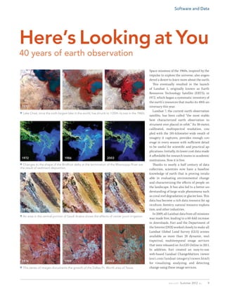
 Lake Chad, once the sixth-largest lake in the world, has shrunk to 1/20th its size in the 1960s.
                                                                                                     satellite, has been called “the most stable,
                                                                                                     best characterized earth observation in-
                                                                                                     strument ever placed in orbit.” Its 30-meter,
                                                                                                     calibrated, multispectral resolution, cou-
                                                                                                     pled with the 185-kilometer-wide swath of
                                                                                                     imagery it captures, provides enough cov-
                                                                                                     erage in every season with sufficient detail
                                                                                                     to be useful for scientific and practical ap-
                                                                                                     plications. Initially, its lower cost data made
                                                                                                     it affordable for research teams in academic
 1972                             1986                              2003
                                                                                                     institutions. Now it is free.
 Changes to the shape of the Birdfoot delta at the termination of the Mississippi River are            Thanks to nearly a half century of data
the result of sediment deposition.                                                                   collection, scientists now have a baseline
                                                                                                     knowledge of earth that is proving invalu-
                                                                                                     able in evaluating environmental change
                                                                                                     and characterizing the effects of people on
                                                                                                     the landscape. It has also led to a better un-
                                                                                                     derstanding of large-scale phenomena such
                                                                                                     as coral reef degradation or glacier loss. Th is
                                                                                                     data has become a rich data resource for ag-
                                                                                                     riculture, forestry, natural resource explora-
 1973                             1989                              2003                             tion, and other industries.
                                                                                                        In 2009, all Landsat data from all missions
 An area in the central portion of Saudi Arabia shows the effects of center pivot irrigation.
                                                                                                     was made free, leading to a 60-fold increase
                                                                                                     in downloads. Esri and the Department of
                                                                                                     the Interior (DOI) worked closely to make all
                                                                                                     Landsat Global Land Survey (GLS) scenes
                                                                                                     available as more than 20 dynamic, mul-
                                                                                                     tispectral, multitemporal image services
                                                                                                     that were released on ArcGIS Online in 2011.
                                                                                                     In addition, Esri created an easy-to-use
                                                                                                     web-based Landsat ChangeMatters viewer
                                                                                                     (esri.com/landsat-imagery/viewer.html)
 1974                             1989                              2003
                                                                                                     for visualizing, analyzing, and detecting
 This series of images documents the growth of the Dallas-Ft. Worth area of Texas.                  change using these image services.


                                                                                                                    esri.com Summer 2012 au        9

More Related Content

What's hot

Dynamic Erosion Model and Monitoring System (DEMIS)
Dynamic Erosion Model and Monitoring System (DEMIS)Dynamic Erosion Model and Monitoring System (DEMIS)
Dynamic Erosion Model and Monitoring System (DEMIS)ExternalEvents
 
SOIL LOSS ESTIMATION IN GIS FRAMEWORK: A CASE STUDY IN CHAMPABATI WATERSHED
SOIL LOSS ESTIMATION IN GIS FRAMEWORK: A CASE STUDY IN CHAMPABATI WATERSHEDSOIL LOSS ESTIMATION IN GIS FRAMEWORK: A CASE STUDY IN CHAMPABATI WATERSHED
SOIL LOSS ESTIMATION IN GIS FRAMEWORK: A CASE STUDY IN CHAMPABATI WATERSHEDAM Publications
 
Demarcation of ground water potential zones using remote sensing & gis
Demarcation of ground water potential zones using remote sensing & gisDemarcation of ground water potential zones using remote sensing & gis
Demarcation of ground water potential zones using remote sensing & gisDebabrata Nandi
 
Assessment of groundwater potential zone in paschim medinipur district, west ...
Assessment of groundwater potential zone in paschim medinipur district, west ...Assessment of groundwater potential zone in paschim medinipur district, west ...
Assessment of groundwater potential zone in paschim medinipur district, west ...Alexander Decker
 
Soil survey and land evaluation
Soil survey and land evaluationSoil survey and land evaluation
Soil survey and land evaluationUmar Munir
 
Patterson.donna
Patterson.donnaPatterson.donna
Patterson.donnaNASAPMC
 
Geomatics Based Landslide Vulnerability Zonation Mapping - Parts Of Nilgiri D...
Geomatics Based Landslide Vulnerability Zonation Mapping - Parts Of Nilgiri D...Geomatics Based Landslide Vulnerability Zonation Mapping - Parts Of Nilgiri D...
Geomatics Based Landslide Vulnerability Zonation Mapping - Parts Of Nilgiri D...IJERA Editor
 
Nasa Langley VCEW 2009 Jones
Nasa Langley VCEW 2009 JonesNasa Langley VCEW 2009 Jones
Nasa Langley VCEW 2009 JonesGreg Jones
 
Notes on different terms of Geography
Notes on different terms of GeographyNotes on different terms of Geography
Notes on different terms of Geographyaprilrousseau
 
Olson aas 2012 goddard v briefed
Olson aas 2012 goddard v briefedOlson aas 2012 goddard v briefed
Olson aas 2012 goddard v briefedgoddardsymposium
 
Assesment of groundwater_potential_zones_for_bruhat_bangalore_mahanagara_pali...
Assesment of groundwater_potential_zones_for_bruhat_bangalore_mahanagara_pali...Assesment of groundwater_potential_zones_for_bruhat_bangalore_mahanagara_pali...
Assesment of groundwater_potential_zones_for_bruhat_bangalore_mahanagara_pali...Mohammed Badiuddin Parvez
 
~~ Hubble discovers ~~ ^^ a new moon ^^ around neptune from nasa at www.googl...
~~ Hubble discovers ~~ ^^ a new moon ^^ around neptune from nasa at www.googl...~~ Hubble discovers ~~ ^^ a new moon ^^ around neptune from nasa at www.googl...
~~ Hubble discovers ~~ ^^ a new moon ^^ around neptune from nasa at www.googl...Deepak Somaji Sawant
 
Digital soil mapping from legacy data and hyperspectral imagery in CapBon (Tu...
Digital soil mapping from legacy data and hyperspectral imagery in CapBon (Tu...Digital soil mapping from legacy data and hyperspectral imagery in CapBon (Tu...
Digital soil mapping from legacy data and hyperspectral imagery in CapBon (Tu...FAO
 
Habitat models: Predicting Sebastes presence in the Del Monte Shalebeds
Habitat models: Predicting Sebastes presence in the Del Monte ShalebedsHabitat models: Predicting Sebastes presence in the Del Monte Shalebeds
Habitat models: Predicting Sebastes presence in the Del Monte ShalebedsLisa Jensen
 
NASA FY 2014 Budget Estimate Presentation
NASA FY 2014 Budget Estimate PresentationNASA FY 2014 Budget Estimate Presentation
NASA FY 2014 Budget Estimate PresentationNASA Dryden
 
international paper30-8f
international paper30-8finternational paper30-8f
international paper30-8fmohamed Shihata
 

What's hot (20)

Dynamic Erosion Model and Monitoring System (DEMIS)
Dynamic Erosion Model and Monitoring System (DEMIS)Dynamic Erosion Model and Monitoring System (DEMIS)
Dynamic Erosion Model and Monitoring System (DEMIS)
 
SOIL LOSS ESTIMATION IN GIS FRAMEWORK: A CASE STUDY IN CHAMPABATI WATERSHED
SOIL LOSS ESTIMATION IN GIS FRAMEWORK: A CASE STUDY IN CHAMPABATI WATERSHEDSOIL LOSS ESTIMATION IN GIS FRAMEWORK: A CASE STUDY IN CHAMPABATI WATERSHED
SOIL LOSS ESTIMATION IN GIS FRAMEWORK: A CASE STUDY IN CHAMPABATI WATERSHED
 
Chapter 2:3 Maps
Chapter 2:3 MapsChapter 2:3 Maps
Chapter 2:3 Maps
 
Demarcation of ground water potential zones using remote sensing & gis
Demarcation of ground water potential zones using remote sensing & gisDemarcation of ground water potential zones using remote sensing & gis
Demarcation of ground water potential zones using remote sensing & gis
 
Assessment of groundwater potential zone in paschim medinipur district, west ...
Assessment of groundwater potential zone in paschim medinipur district, west ...Assessment of groundwater potential zone in paschim medinipur district, west ...
Assessment of groundwater potential zone in paschim medinipur district, west ...
 
Soil survey and land evaluation
Soil survey and land evaluationSoil survey and land evaluation
Soil survey and land evaluation
 
Identifying karst and manure management
Identifying karst and manure managementIdentifying karst and manure management
Identifying karst and manure management
 
Patterson.donna
Patterson.donnaPatterson.donna
Patterson.donna
 
Geomatics Based Landslide Vulnerability Zonation Mapping - Parts Of Nilgiri D...
Geomatics Based Landslide Vulnerability Zonation Mapping - Parts Of Nilgiri D...Geomatics Based Landslide Vulnerability Zonation Mapping - Parts Of Nilgiri D...
Geomatics Based Landslide Vulnerability Zonation Mapping - Parts Of Nilgiri D...
 
Nasa Langley VCEW 2009 Jones
Nasa Langley VCEW 2009 JonesNasa Langley VCEW 2009 Jones
Nasa Langley VCEW 2009 Jones
 
Notes on different terms of Geography
Notes on different terms of GeographyNotes on different terms of Geography
Notes on different terms of Geography
 
Olson aas 2012 goddard v briefed
Olson aas 2012 goddard v briefedOlson aas 2012 goddard v briefed
Olson aas 2012 goddard v briefed
 
Assesment of groundwater_potential_zones_for_bruhat_bangalore_mahanagara_pali...
Assesment of groundwater_potential_zones_for_bruhat_bangalore_mahanagara_pali...Assesment of groundwater_potential_zones_for_bruhat_bangalore_mahanagara_pali...
Assesment of groundwater_potential_zones_for_bruhat_bangalore_mahanagara_pali...
 
~~ Hubble discovers ~~ ^^ a new moon ^^ around neptune from nasa at www.googl...
~~ Hubble discovers ~~ ^^ a new moon ^^ around neptune from nasa at www.googl...~~ Hubble discovers ~~ ^^ a new moon ^^ around neptune from nasa at www.googl...
~~ Hubble discovers ~~ ^^ a new moon ^^ around neptune from nasa at www.googl...
 
Digital soil mapping from legacy data and hyperspectral imagery in CapBon (Tu...
Digital soil mapping from legacy data and hyperspectral imagery in CapBon (Tu...Digital soil mapping from legacy data and hyperspectral imagery in CapBon (Tu...
Digital soil mapping from legacy data and hyperspectral imagery in CapBon (Tu...
 
Habitat models: Predicting Sebastes presence in the Del Monte Shalebeds
Habitat models: Predicting Sebastes presence in the Del Monte ShalebedsHabitat models: Predicting Sebastes presence in the Del Monte Shalebeds
Habitat models: Predicting Sebastes presence in the Del Monte Shalebeds
 
Chapter 1
Chapter 1 Chapter 1
Chapter 1
 
NASA FY 2014 Budget Estimate Presentation
NASA FY 2014 Budget Estimate PresentationNASA FY 2014 Budget Estimate Presentation
NASA FY 2014 Budget Estimate Presentation
 
international paper30-8f
international paper30-8finternational paper30-8f
international paper30-8f
 
Chapter 1
Chapter 1Chapter 1
Chapter 1
 

Viewers also liked

Viewers also liked (15)

Tadj
TadjTadj
Tadj
 
Civil Es Noticia
Civil Es NoticiaCivil Es Noticia
Civil Es Noticia
 
Fisciano ospita la delegazione del Consiglio comunale di Napoli
Fisciano ospita la delegazione del Consiglio comunale di NapoliFisciano ospita la delegazione del Consiglio comunale di Napoli
Fisciano ospita la delegazione del Consiglio comunale di Napoli
 
Coolio articulo in peope
Coolio articulo in peopeCoolio articulo in peope
Coolio articulo in peope
 
Curso insercion laboral
Curso insercion laboralCurso insercion laboral
Curso insercion laboral
 
Zoriontsuago bizi ahal izateko
Zoriontsuago bizi ahal izatekoZoriontsuago bizi ahal izateko
Zoriontsuago bizi ahal izateko
 
Jindal está en situación difícil y muestra debilidad económica
Jindal está en situación difícil y muestra debilidad económicaJindal está en situación difícil y muestra debilidad económica
Jindal está en situación difícil y muestra debilidad económica
 
Condition
ConditionCondition
Condition
 
Migraciones preparacion foro
Migraciones preparacion foroMigraciones preparacion foro
Migraciones preparacion foro
 
Sommerferie 2012
Sommerferie 2012Sommerferie 2012
Sommerferie 2012
 
El valor
El valorEl valor
El valor
 
Trabalho
TrabalhoTrabalho
Trabalho
 
Diptic jornada2012[1]
Diptic jornada2012[1]Diptic jornada2012[1]
Diptic jornada2012[1]
 
33
3333
33
 
Carnaval
CarnavalCarnaval
Carnaval
 

Similar to Here's Looking at You

How to develop a Sense of Place
How to develop a Sense of PlaceHow to develop a Sense of Place
How to develop a Sense of PlaceGeoBlogs
 
In Situ Resource Utilization by Humans in Planetary Analog Environments
In Situ Resource Utilization by Humans in Planetary Analog EnvironmentsIn Situ Resource Utilization by Humans in Planetary Analog Environments
In Situ Resource Utilization by Humans in Planetary Analog EnvironmentsBrian Shiro
 
WE1.L09 - AN OVERVIEW OF THE DESDYNI MISSION
WE1.L09 - AN OVERVIEW OF THE DESDYNI MISSIONWE1.L09 - AN OVERVIEW OF THE DESDYNI MISSION
WE1.L09 - AN OVERVIEW OF THE DESDYNI MISSIONgrssieee
 
[International agrophysics] ground penetrating radar for underground sensing ...
[International agrophysics] ground penetrating radar for underground sensing ...[International agrophysics] ground penetrating radar for underground sensing ...
[International agrophysics] ground penetrating radar for underground sensing ...Minal Ghugal
 
FINAL PRINT - PXRF Soil Salinity SS
FINAL PRINT - PXRF Soil Salinity SSFINAL PRINT - PXRF Soil Salinity SS
FINAL PRINT - PXRF Soil Salinity SSCourtney Nelson
 
FINAL PRINT - PXRF Soil Salinity SS
FINAL PRINT - PXRF Soil Salinity SSFINAL PRINT - PXRF Soil Salinity SS
FINAL PRINT - PXRF Soil Salinity SSCourtney Nelson
 
In Situ Geophysical Exploration by Humans in Mars Analog Environments
In Situ Geophysical Exploration by Humans in Mars Analog EnvironmentsIn Situ Geophysical Exploration by Humans in Mars Analog Environments
In Situ Geophysical Exploration by Humans in Mars Analog EnvironmentsBrian Shiro
 
GPR 2016 Poster_Lane_A
GPR 2016 Poster_Lane_AGPR 2016 Poster_Lane_A
GPR 2016 Poster_Lane_AAngela Lane
 
Predicting and mapping soil properties using proximal/remote sensing by Zhou ...
Predicting and mapping soil properties using proximal/remote sensing by Zhou ...Predicting and mapping soil properties using proximal/remote sensing by Zhou ...
Predicting and mapping soil properties using proximal/remote sensing by Zhou ...FAO
 
Landuse and Landcover analysis using Remote Sensing and GIS: A Case Study in ...
Landuse and Landcover analysis using Remote Sensing and GIS: A Case Study in ...Landuse and Landcover analysis using Remote Sensing and GIS: A Case Study in ...
Landuse and Landcover analysis using Remote Sensing and GIS: A Case Study in ...IRJET Journal
 
Presentation on Aerosols, cloud properties
Presentation on Aerosols, cloud properties Presentation on Aerosols, cloud properties
Presentation on Aerosols, cloud properties Esayas Meresa
 
Using Remote Sensing Techniques For Monitoring Ecological Changes In Lakes: C...
Using Remote Sensing Techniques For Monitoring Ecological Changes In Lakes: C...Using Remote Sensing Techniques For Monitoring Ecological Changes In Lakes: C...
Using Remote Sensing Techniques For Monitoring Ecological Changes In Lakes: C...IJERA Editor
 
Minning Application and Remote Sensing Using Aster Imagery
Minning Application and Remote Sensing Using Aster ImageryMinning Application and Remote Sensing Using Aster Imagery
Minning Application and Remote Sensing Using Aster ImageryHrishikesh Satpute
 
Groundwater Potential Zone Identification of Karwi Area, Mandakini River Basi...
Groundwater Potential Zone Identification of Karwi Area, Mandakini River Basi...Groundwater Potential Zone Identification of Karwi Area, Mandakini River Basi...
Groundwater Potential Zone Identification of Karwi Area, Mandakini River Basi...inventionjournals
 
The International Journal of Engineering and Science (The IJES)
The International Journal of Engineering and Science (The IJES)The International Journal of Engineering and Science (The IJES)
The International Journal of Engineering and Science (The IJES)theijes
 

Similar to Here's Looking at You (20)

How to develop a Sense of Place
How to develop a Sense of PlaceHow to develop a Sense of Place
How to develop a Sense of Place
 
In Situ Resource Utilization by Humans in Planetary Analog Environments
In Situ Resource Utilization by Humans in Planetary Analog EnvironmentsIn Situ Resource Utilization by Humans in Planetary Analog Environments
In Situ Resource Utilization by Humans in Planetary Analog Environments
 
WE1.L09 - AN OVERVIEW OF THE DESDYNI MISSION
WE1.L09 - AN OVERVIEW OF THE DESDYNI MISSIONWE1.L09 - AN OVERVIEW OF THE DESDYNI MISSION
WE1.L09 - AN OVERVIEW OF THE DESDYNI MISSION
 
Conclusive Results
Conclusive ResultsConclusive Results
Conclusive Results
 
[International agrophysics] ground penetrating radar for underground sensing ...
[International agrophysics] ground penetrating radar for underground sensing ...[International agrophysics] ground penetrating radar for underground sensing ...
[International agrophysics] ground penetrating radar for underground sensing ...
 
FINAL PRINT - PXRF Soil Salinity SS
FINAL PRINT - PXRF Soil Salinity SSFINAL PRINT - PXRF Soil Salinity SS
FINAL PRINT - PXRF Soil Salinity SS
 
FINAL PRINT - PXRF Soil Salinity SS
FINAL PRINT - PXRF Soil Salinity SSFINAL PRINT - PXRF Soil Salinity SS
FINAL PRINT - PXRF Soil Salinity SS
 
In Situ Geophysical Exploration by Humans in Mars Analog Environments
In Situ Geophysical Exploration by Humans in Mars Analog EnvironmentsIn Situ Geophysical Exploration by Humans in Mars Analog Environments
In Situ Geophysical Exploration by Humans in Mars Analog Environments
 
Seminar
Seminar Seminar
Seminar
 
GPR 2016 Poster_Lane_A
GPR 2016 Poster_Lane_AGPR 2016 Poster_Lane_A
GPR 2016 Poster_Lane_A
 
Predicting and mapping soil properties using proximal/remote sensing by Zhou ...
Predicting and mapping soil properties using proximal/remote sensing by Zhou ...Predicting and mapping soil properties using proximal/remote sensing by Zhou ...
Predicting and mapping soil properties using proximal/remote sensing by Zhou ...
 
Landuse and Landcover analysis using Remote Sensing and GIS: A Case Study in ...
Landuse and Landcover analysis using Remote Sensing and GIS: A Case Study in ...Landuse and Landcover analysis using Remote Sensing and GIS: A Case Study in ...
Landuse and Landcover analysis using Remote Sensing and GIS: A Case Study in ...
 
Presentation on Aerosols, cloud properties
Presentation on Aerosols, cloud properties Presentation on Aerosols, cloud properties
Presentation on Aerosols, cloud properties
 
Using Remote Sensing Techniques For Monitoring Ecological Changes In Lakes: C...
Using Remote Sensing Techniques For Monitoring Ecological Changes In Lakes: C...Using Remote Sensing Techniques For Monitoring Ecological Changes In Lakes: C...
Using Remote Sensing Techniques For Monitoring Ecological Changes In Lakes: C...
 
Using Remote Sensing Techniques For Monitoring Ecological Changes In Lakes: C...
Using Remote Sensing Techniques For Monitoring Ecological Changes In Lakes: C...Using Remote Sensing Techniques For Monitoring Ecological Changes In Lakes: C...
Using Remote Sensing Techniques For Monitoring Ecological Changes In Lakes: C...
 
Minning Application and Remote Sensing Using Aster Imagery
Minning Application and Remote Sensing Using Aster ImageryMinning Application and Remote Sensing Using Aster Imagery
Minning Application and Remote Sensing Using Aster Imagery
 
Earth
EarthEarth
Earth
 
Groundwater Potential Zone Identification of Karwi Area, Mandakini River Basi...
Groundwater Potential Zone Identification of Karwi Area, Mandakini River Basi...Groundwater Potential Zone Identification of Karwi Area, Mandakini River Basi...
Groundwater Potential Zone Identification of Karwi Area, Mandakini River Basi...
 
The International Journal of Engineering and Science (The IJES)
The International Journal of Engineering and Science (The IJES)The International Journal of Engineering and Science (The IJES)
The International Journal of Engineering and Science (The IJES)
 
Eso1134a
Eso1134aEso1134a
Eso1134a
 

More from Esri

INIA- CISA: Análisis de las amenazas en la fauna silvestre
INIA- CISA: Análisis de las amenazas en la fauna silvestreINIA- CISA: Análisis de las amenazas en la fauna silvestre
INIA- CISA: Análisis de las amenazas en la fauna silvestreEsri
 
Aena Aeropuerto Adolfo Suárez-Barajas crea potentes aplicaciones para sus cli...
Aena Aeropuerto Adolfo Suárez-Barajas crea potentes aplicaciones para sus cli...Aena Aeropuerto Adolfo Suárez-Barajas crea potentes aplicaciones para sus cli...
Aena Aeropuerto Adolfo Suárez-Barajas crea potentes aplicaciones para sus cli...Esri
 
Plataforma Smart City de Móstoles
Plataforma Smart City de MóstolesPlataforma Smart City de Móstoles
Plataforma Smart City de MóstolesEsri
 
ArcGIS Online para Organizaciones
ArcGIS Online para OrganizacionesArcGIS Online para Organizaciones
ArcGIS Online para OrganizacionesEsri
 
Molina de Segura se convierte en una smart city
Molina de Segura se convierte en una smart cityMolina de Segura se convierte en una smart city
Molina de Segura se convierte en una smart cityEsri
 
Portal for ArcGIS
Portal for ArcGISPortal for ArcGIS
Portal for ArcGISEsri
 
GIS-Based Web Services Provide Rapid Analysis and Dissemination of Maritime Data
GIS-Based Web Services Provide Rapid Analysis and Dissemination of Maritime DataGIS-Based Web Services Provide Rapid Analysis and Dissemination of Maritime Data
GIS-Based Web Services Provide Rapid Analysis and Dissemination of Maritime DataEsri
 
An Effective Tool for Drinking Water Protection
An Effective Tool for Drinking Water ProtectionAn Effective Tool for Drinking Water Protection
An Effective Tool for Drinking Water ProtectionEsri
 
GeoCollector for ArcPad
GeoCollector for ArcPadGeoCollector for ArcPad
GeoCollector for ArcPadEsri
 
GeoCollector for ArcGIS for Windows Mobile
GeoCollector for ArcGIS for Windows MobileGeoCollector for ArcGIS for Windows Mobile
GeoCollector for ArcGIS for Windows MobileEsri
 
Data Appliance for ArcGIS
Data Appliance for ArcGISData Appliance for ArcGIS
Data Appliance for ArcGISEsri
 
Esri and BlackBridge
Esri and BlackBridgeEsri and BlackBridge
Esri and BlackBridgeEsri
 
GeoPlanner for ArcGIS
GeoPlanner for ArcGISGeoPlanner for ArcGIS
GeoPlanner for ArcGISEsri
 
Esri and AccuWeather
Esri and AccuWeatherEsri and AccuWeather
Esri and AccuWeatherEsri
 
Esri and Airbus Defense & Space
Esri and Airbus Defense & SpaceEsri and Airbus Defense & Space
Esri and Airbus Defense & SpaceEsri
 
Esri US Data Fact Sheet
Esri US Data Fact SheetEsri US Data Fact Sheet
Esri US Data Fact SheetEsri
 
ArcGIS for Server on Microsoft Azure Jumpstart
ArcGIS for Server on Microsoft Azure JumpstartArcGIS for Server on Microsoft Azure Jumpstart
ArcGIS for Server on Microsoft Azure JumpstartEsri
 
ArcGIS for the Military--Maritime Operations
ArcGIS for the Military--Maritime OperationsArcGIS for the Military--Maritime Operations
ArcGIS for the Military--Maritime OperationsEsri
 
Esri Geoportal Server
Esri Geoportal ServerEsri Geoportal Server
Esri Geoportal ServerEsri
 
ArcGIS GeoEvent Extension for Server
ArcGIS GeoEvent Extension for ServerArcGIS GeoEvent Extension for Server
ArcGIS GeoEvent Extension for ServerEsri
 

More from Esri (20)

INIA- CISA: Análisis de las amenazas en la fauna silvestre
INIA- CISA: Análisis de las amenazas en la fauna silvestreINIA- CISA: Análisis de las amenazas en la fauna silvestre
INIA- CISA: Análisis de las amenazas en la fauna silvestre
 
Aena Aeropuerto Adolfo Suárez-Barajas crea potentes aplicaciones para sus cli...
Aena Aeropuerto Adolfo Suárez-Barajas crea potentes aplicaciones para sus cli...Aena Aeropuerto Adolfo Suárez-Barajas crea potentes aplicaciones para sus cli...
Aena Aeropuerto Adolfo Suárez-Barajas crea potentes aplicaciones para sus cli...
 
Plataforma Smart City de Móstoles
Plataforma Smart City de MóstolesPlataforma Smart City de Móstoles
Plataforma Smart City de Móstoles
 
ArcGIS Online para Organizaciones
ArcGIS Online para OrganizacionesArcGIS Online para Organizaciones
ArcGIS Online para Organizaciones
 
Molina de Segura se convierte en una smart city
Molina de Segura se convierte en una smart cityMolina de Segura se convierte en una smart city
Molina de Segura se convierte en una smart city
 
Portal for ArcGIS
Portal for ArcGISPortal for ArcGIS
Portal for ArcGIS
 
GIS-Based Web Services Provide Rapid Analysis and Dissemination of Maritime Data
GIS-Based Web Services Provide Rapid Analysis and Dissemination of Maritime DataGIS-Based Web Services Provide Rapid Analysis and Dissemination of Maritime Data
GIS-Based Web Services Provide Rapid Analysis and Dissemination of Maritime Data
 
An Effective Tool for Drinking Water Protection
An Effective Tool for Drinking Water ProtectionAn Effective Tool for Drinking Water Protection
An Effective Tool for Drinking Water Protection
 
GeoCollector for ArcPad
GeoCollector for ArcPadGeoCollector for ArcPad
GeoCollector for ArcPad
 
GeoCollector for ArcGIS for Windows Mobile
GeoCollector for ArcGIS for Windows MobileGeoCollector for ArcGIS for Windows Mobile
GeoCollector for ArcGIS for Windows Mobile
 
Data Appliance for ArcGIS
Data Appliance for ArcGISData Appliance for ArcGIS
Data Appliance for ArcGIS
 
Esri and BlackBridge
Esri and BlackBridgeEsri and BlackBridge
Esri and BlackBridge
 
GeoPlanner for ArcGIS
GeoPlanner for ArcGISGeoPlanner for ArcGIS
GeoPlanner for ArcGIS
 
Esri and AccuWeather
Esri and AccuWeatherEsri and AccuWeather
Esri and AccuWeather
 
Esri and Airbus Defense & Space
Esri and Airbus Defense & SpaceEsri and Airbus Defense & Space
Esri and Airbus Defense & Space
 
Esri US Data Fact Sheet
Esri US Data Fact SheetEsri US Data Fact Sheet
Esri US Data Fact Sheet
 
ArcGIS for Server on Microsoft Azure Jumpstart
ArcGIS for Server on Microsoft Azure JumpstartArcGIS for Server on Microsoft Azure Jumpstart
ArcGIS for Server on Microsoft Azure Jumpstart
 
ArcGIS for the Military--Maritime Operations
ArcGIS for the Military--Maritime OperationsArcGIS for the Military--Maritime Operations
ArcGIS for the Military--Maritime Operations
 
Esri Geoportal Server
Esri Geoportal ServerEsri Geoportal Server
Esri Geoportal Server
 
ArcGIS GeoEvent Extension for Server
ArcGIS GeoEvent Extension for ServerArcGIS GeoEvent Extension for Server
ArcGIS GeoEvent Extension for Server
 

Recently uploaded

How to Troubleshoot Apps for the Modern Connected Worker
How to Troubleshoot Apps for the Modern Connected WorkerHow to Troubleshoot Apps for the Modern Connected Worker
How to Troubleshoot Apps for the Modern Connected WorkerThousandEyes
 
GenAI Risks & Security Meetup 01052024.pdf
GenAI Risks & Security Meetup 01052024.pdfGenAI Risks & Security Meetup 01052024.pdf
GenAI Risks & Security Meetup 01052024.pdflior mazor
 
08448380779 Call Girls In Diplomatic Enclave Women Seeking Men
08448380779 Call Girls In Diplomatic Enclave Women Seeking Men08448380779 Call Girls In Diplomatic Enclave Women Seeking Men
08448380779 Call Girls In Diplomatic Enclave Women Seeking MenDelhi Call girls
 
Mastering MySQL Database Architecture: Deep Dive into MySQL Shell and MySQL R...
Mastering MySQL Database Architecture: Deep Dive into MySQL Shell and MySQL R...Mastering MySQL Database Architecture: Deep Dive into MySQL Shell and MySQL R...
Mastering MySQL Database Architecture: Deep Dive into MySQL Shell and MySQL R...Miguel Araújo
 
Presentation on how to chat with PDF using ChatGPT code interpreter
Presentation on how to chat with PDF using ChatGPT code interpreterPresentation on how to chat with PDF using ChatGPT code interpreter
Presentation on how to chat with PDF using ChatGPT code interpreternaman860154
 
EIS-Webinar-Prompt-Knowledge-Eng-2024-04-08.pptx
EIS-Webinar-Prompt-Knowledge-Eng-2024-04-08.pptxEIS-Webinar-Prompt-Knowledge-Eng-2024-04-08.pptx
EIS-Webinar-Prompt-Knowledge-Eng-2024-04-08.pptxEarley Information Science
 
GenCyber Cyber Security Day Presentation
GenCyber Cyber Security Day PresentationGenCyber Cyber Security Day Presentation
GenCyber Cyber Security Day PresentationMichael W. Hawkins
 
From Event to Action: Accelerate Your Decision Making with Real-Time Automation
From Event to Action: Accelerate Your Decision Making with Real-Time AutomationFrom Event to Action: Accelerate Your Decision Making with Real-Time Automation
From Event to Action: Accelerate Your Decision Making with Real-Time AutomationSafe Software
 
Automating Google Workspace (GWS) & more with Apps Script
Automating Google Workspace (GWS) & more with Apps ScriptAutomating Google Workspace (GWS) & more with Apps Script
Automating Google Workspace (GWS) & more with Apps Scriptwesley chun
 
IAC 2024 - IA Fast Track to Search Focused AI Solutions
IAC 2024 - IA Fast Track to Search Focused AI SolutionsIAC 2024 - IA Fast Track to Search Focused AI Solutions
IAC 2024 - IA Fast Track to Search Focused AI SolutionsEnterprise Knowledge
 
The Role of Taxonomy and Ontology in Semantic Layers - Heather Hedden.pdf
The Role of Taxonomy and Ontology in Semantic Layers - Heather Hedden.pdfThe Role of Taxonomy and Ontology in Semantic Layers - Heather Hedden.pdf
The Role of Taxonomy and Ontology in Semantic Layers - Heather Hedden.pdfEnterprise Knowledge
 
08448380779 Call Girls In Friends Colony Women Seeking Men
08448380779 Call Girls In Friends Colony Women Seeking Men08448380779 Call Girls In Friends Colony Women Seeking Men
08448380779 Call Girls In Friends Colony Women Seeking MenDelhi Call girls
 
🐬 The future of MySQL is Postgres 🐘
🐬  The future of MySQL is Postgres   🐘🐬  The future of MySQL is Postgres   🐘
🐬 The future of MySQL is Postgres 🐘RTylerCroy
 
Boost Fertility New Invention Ups Success Rates.pdf
Boost Fertility New Invention Ups Success Rates.pdfBoost Fertility New Invention Ups Success Rates.pdf
Boost Fertility New Invention Ups Success Rates.pdfsudhanshuwaghmare1
 
Apidays Singapore 2024 - Building Digital Trust in a Digital Economy by Veron...
Apidays Singapore 2024 - Building Digital Trust in a Digital Economy by Veron...Apidays Singapore 2024 - Building Digital Trust in a Digital Economy by Veron...
Apidays Singapore 2024 - Building Digital Trust in a Digital Economy by Veron...apidays
 
Understanding Discord NSFW Servers A Guide for Responsible Users.pdf
Understanding Discord NSFW Servers A Guide for Responsible Users.pdfUnderstanding Discord NSFW Servers A Guide for Responsible Users.pdf
Understanding Discord NSFW Servers A Guide for Responsible Users.pdfUK Journal
 
[2024]Digital Global Overview Report 2024 Meltwater.pdf
[2024]Digital Global Overview Report 2024 Meltwater.pdf[2024]Digital Global Overview Report 2024 Meltwater.pdf
[2024]Digital Global Overview Report 2024 Meltwater.pdfhans926745
 
CNv6 Instructor Chapter 6 Quality of Service
CNv6 Instructor Chapter 6 Quality of ServiceCNv6 Instructor Chapter 6 Quality of Service
CNv6 Instructor Chapter 6 Quality of Servicegiselly40
 
Bajaj Allianz Life Insurance Company - Insurer Innovation Award 2024
Bajaj Allianz Life Insurance Company - Insurer Innovation Award 2024Bajaj Allianz Life Insurance Company - Insurer Innovation Award 2024
Bajaj Allianz Life Insurance Company - Insurer Innovation Award 2024The Digital Insurer
 
presentation ICT roal in 21st century education
presentation ICT roal in 21st century educationpresentation ICT roal in 21st century education
presentation ICT roal in 21st century educationjfdjdjcjdnsjd
 

Recently uploaded (20)

How to Troubleshoot Apps for the Modern Connected Worker
How to Troubleshoot Apps for the Modern Connected WorkerHow to Troubleshoot Apps for the Modern Connected Worker
How to Troubleshoot Apps for the Modern Connected Worker
 
GenAI Risks & Security Meetup 01052024.pdf
GenAI Risks & Security Meetup 01052024.pdfGenAI Risks & Security Meetup 01052024.pdf
GenAI Risks & Security Meetup 01052024.pdf
 
08448380779 Call Girls In Diplomatic Enclave Women Seeking Men
08448380779 Call Girls In Diplomatic Enclave Women Seeking Men08448380779 Call Girls In Diplomatic Enclave Women Seeking Men
08448380779 Call Girls In Diplomatic Enclave Women Seeking Men
 
Mastering MySQL Database Architecture: Deep Dive into MySQL Shell and MySQL R...
Mastering MySQL Database Architecture: Deep Dive into MySQL Shell and MySQL R...Mastering MySQL Database Architecture: Deep Dive into MySQL Shell and MySQL R...
Mastering MySQL Database Architecture: Deep Dive into MySQL Shell and MySQL R...
 
Presentation on how to chat with PDF using ChatGPT code interpreter
Presentation on how to chat with PDF using ChatGPT code interpreterPresentation on how to chat with PDF using ChatGPT code interpreter
Presentation on how to chat with PDF using ChatGPT code interpreter
 
EIS-Webinar-Prompt-Knowledge-Eng-2024-04-08.pptx
EIS-Webinar-Prompt-Knowledge-Eng-2024-04-08.pptxEIS-Webinar-Prompt-Knowledge-Eng-2024-04-08.pptx
EIS-Webinar-Prompt-Knowledge-Eng-2024-04-08.pptx
 
GenCyber Cyber Security Day Presentation
GenCyber Cyber Security Day PresentationGenCyber Cyber Security Day Presentation
GenCyber Cyber Security Day Presentation
 
From Event to Action: Accelerate Your Decision Making with Real-Time Automation
From Event to Action: Accelerate Your Decision Making with Real-Time AutomationFrom Event to Action: Accelerate Your Decision Making with Real-Time Automation
From Event to Action: Accelerate Your Decision Making with Real-Time Automation
 
Automating Google Workspace (GWS) & more with Apps Script
Automating Google Workspace (GWS) & more with Apps ScriptAutomating Google Workspace (GWS) & more with Apps Script
Automating Google Workspace (GWS) & more with Apps Script
 
IAC 2024 - IA Fast Track to Search Focused AI Solutions
IAC 2024 - IA Fast Track to Search Focused AI SolutionsIAC 2024 - IA Fast Track to Search Focused AI Solutions
IAC 2024 - IA Fast Track to Search Focused AI Solutions
 
The Role of Taxonomy and Ontology in Semantic Layers - Heather Hedden.pdf
The Role of Taxonomy and Ontology in Semantic Layers - Heather Hedden.pdfThe Role of Taxonomy and Ontology in Semantic Layers - Heather Hedden.pdf
The Role of Taxonomy and Ontology in Semantic Layers - Heather Hedden.pdf
 
08448380779 Call Girls In Friends Colony Women Seeking Men
08448380779 Call Girls In Friends Colony Women Seeking Men08448380779 Call Girls In Friends Colony Women Seeking Men
08448380779 Call Girls In Friends Colony Women Seeking Men
 
🐬 The future of MySQL is Postgres 🐘
🐬  The future of MySQL is Postgres   🐘🐬  The future of MySQL is Postgres   🐘
🐬 The future of MySQL is Postgres 🐘
 
Boost Fertility New Invention Ups Success Rates.pdf
Boost Fertility New Invention Ups Success Rates.pdfBoost Fertility New Invention Ups Success Rates.pdf
Boost Fertility New Invention Ups Success Rates.pdf
 
Apidays Singapore 2024 - Building Digital Trust in a Digital Economy by Veron...
Apidays Singapore 2024 - Building Digital Trust in a Digital Economy by Veron...Apidays Singapore 2024 - Building Digital Trust in a Digital Economy by Veron...
Apidays Singapore 2024 - Building Digital Trust in a Digital Economy by Veron...
 
Understanding Discord NSFW Servers A Guide for Responsible Users.pdf
Understanding Discord NSFW Servers A Guide for Responsible Users.pdfUnderstanding Discord NSFW Servers A Guide for Responsible Users.pdf
Understanding Discord NSFW Servers A Guide for Responsible Users.pdf
 
[2024]Digital Global Overview Report 2024 Meltwater.pdf
[2024]Digital Global Overview Report 2024 Meltwater.pdf[2024]Digital Global Overview Report 2024 Meltwater.pdf
[2024]Digital Global Overview Report 2024 Meltwater.pdf
 
CNv6 Instructor Chapter 6 Quality of Service
CNv6 Instructor Chapter 6 Quality of ServiceCNv6 Instructor Chapter 6 Quality of Service
CNv6 Instructor Chapter 6 Quality of Service
 
Bajaj Allianz Life Insurance Company - Insurer Innovation Award 2024
Bajaj Allianz Life Insurance Company - Insurer Innovation Award 2024Bajaj Allianz Life Insurance Company - Insurer Innovation Award 2024
Bajaj Allianz Life Insurance Company - Insurer Innovation Award 2024
 
presentation ICT roal in 21st century education
presentation ICT roal in 21st century educationpresentation ICT roal in 21st century education
presentation ICT roal in 21st century education
 

Here's Looking at You

  • 1. Software and Data Here’s Looking at You 40 years of earth observation Space missions of the 1960s, inspired by the impulse to explore the universe, also engen- dered a desire to learn more about the earth. Th is eventually resulted in the launch of Landsat 1, originally known as Earth Resources Technology Satellite (ERTS), in 1972, which began a systematic inventory of the earth’s resources that marks its 40th an- 1972 1987 2002 niversary this year. Landsat 7, the current earth observation  Lake Chad, once the sixth-largest lake in the world, has shrunk to 1/20th its size in the 1960s. satellite, has been called “the most stable, best characterized earth observation in- strument ever placed in orbit.” Its 30-meter, calibrated, multispectral resolution, cou- pled with the 185-kilometer-wide swath of imagery it captures, provides enough cov- erage in every season with sufficient detail to be useful for scientific and practical ap- plications. Initially, its lower cost data made it affordable for research teams in academic 1972 1986 2003 institutions. Now it is free.  Changes to the shape of the Birdfoot delta at the termination of the Mississippi River are Thanks to nearly a half century of data the result of sediment deposition. collection, scientists now have a baseline knowledge of earth that is proving invalu- able in evaluating environmental change and characterizing the effects of people on the landscape. It has also led to a better un- derstanding of large-scale phenomena such as coral reef degradation or glacier loss. Th is data has become a rich data resource for ag- riculture, forestry, natural resource explora- 1973 1989 2003 tion, and other industries. In 2009, all Landsat data from all missions  An area in the central portion of Saudi Arabia shows the effects of center pivot irrigation. was made free, leading to a 60-fold increase in downloads. Esri and the Department of the Interior (DOI) worked closely to make all Landsat Global Land Survey (GLS) scenes available as more than 20 dynamic, mul- tispectral, multitemporal image services that were released on ArcGIS Online in 2011. In addition, Esri created an easy-to-use web-based Landsat ChangeMatters viewer (esri.com/landsat-imagery/viewer.html) 1974 1989 2003 for visualizing, analyzing, and detecting  This series of images documents the growth of the Dallas-Ft. Worth area of Texas. change using these image services. esri.com Summer 2012 au 9