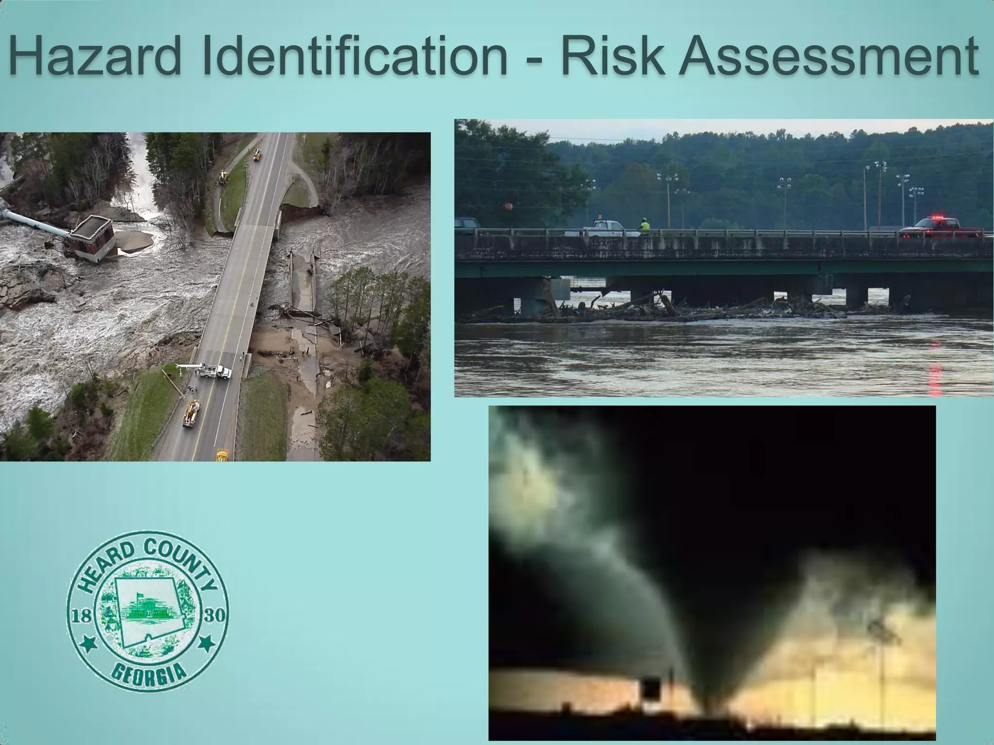
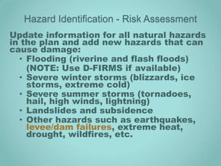
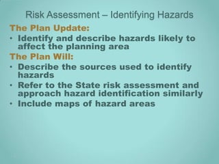
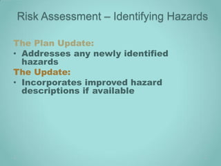
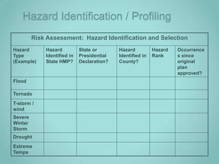
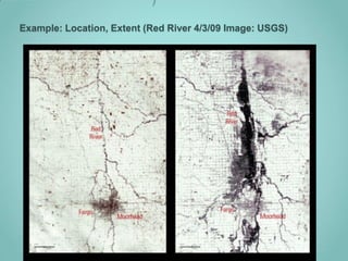
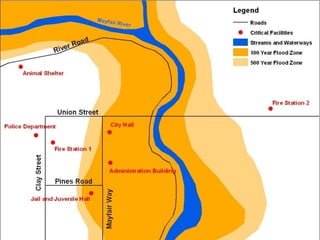
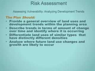
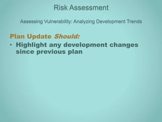
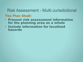
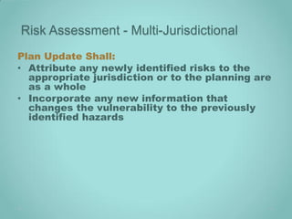
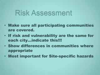
Hazard Identification - Risk Assessment
Update information for all natural hazards
in the plan and add new hazards that can
cause damage:
  • Flooding (riverine and flash floods)
    (NOTE: Use D-FIRMS if available)
  • Severe winter storms (blizzards, ice
    storms, extreme cold)
  • Severe summer storms (tornadoes,
    hail, high winds, lightning)
  • Landslides and subsidence
  • Other hazards such as earthquakes,
    levee/dam failures, extreme heat,
    drought, wildfires, etc.
Risk Assessment – Identifying Hazards
The Plan Update:
• Identify and describe hazards likely to
  affect the planning area
The Plan Will:
• Describe the sources used to identify
  hazards
• Refer to the State risk assessment and
  approach hazard identification similarly
• Include maps of hazard areas
Risk Assessment – Identifying Hazards

The Plan Update:
• Addresses any newly identified
  hazards
The Update:
• Incorporates improved hazard
  descriptions if available
Hazard Identification / Profiling
         Risk Assessment: Hazard Identification and Selection
Hazard       Hazard          State or       Hazard          Hazard   Occurrence
Type         Identified in   Presidential   Identified in   Rank     s since
(Example)    State HMP?      Declaration?   County?                  original
                                                                     plan
                                                                     approved?
Flood

Tornado
T-storm /
wind
Severe
Winter
Storm
Drought
Extreme
Temps
Risk Assessment - Profiling Hazards
The Plan Shall:
• Provide a description of previous
  occurrences, location, extent (severity or
  magnitude), and probability of future
  occurrence for each identified hazard
Plan Update Shall:
• Continue to describe occurrences of hazards
  included in the previous plan
• Incorporate any new historical records or
  hazard data
• Address any data deficiencies that were
  identified in the previous plan
Hazard Profiles
• Describe the recognized natural hazards
  likely to affect the jurisdiction –
• Include updated info:
   Nature:       Description of the hazard
   History:      Past occurrences and details
   Location:     Area that is impacted
   Extent:       Range of potential
                 magnitude or severity
                 (example: EF1)
   Probability: Statistical measures that the
                 event might happen
Hazard Profiles
The natural hazards are required to be
 ranked. Example:
    1. Flooding
    2. Wildfire
    3. Dam/Levee Failure
    4. Drought
)

Example: Location, Extent (Red River 4/3/09 Image: USGS)
Assessing Vulnerability: Identifying Structures
• An overview of the community’s
  vulnerability is a summary of the hazard’s
  impact on the community and its
  vulnerable structures.
• This summary shall include, by type of
  hazard, a general description of the types
  of structures affected by the hazards.
  Examples include, but are not limited to,
  buildings, infrastructure, critical facilities,
  structures that house the elderly or
  disabled, and areas where low-income
  populations reside.
Assessing Vulnerability:
          Identifying Structures
• The overview shall also include a general
  description of the hazard’s impact to the
  vulnerable structures. Vulnerable
  structures include those located within
 geographic areas susceptible to a
 particular hazard. Certain hazards may
 affect the entire community or planning
 area.
o The summary can be presented in terms of
  dollar value or percentages of damage.
Type of           Number of Structures          Value of Structures             Number of People
Structure
               # in Com-    # in     % in  $ in Com-    $ in     % in      # in      # in     % in
                munity     Hazard   Hazard  munity     Hazard   Hazard    Com-      Hazard   Hazard
                            Area     Area               Area     Area     munity     Area     Area


Residential       61        16        25     3.92m     .44m       11       403        69       7


Commercial        5          4        80     6.50m     4.5m       69       570       345      61


Industrial        0          0        0        0         0            0     0         0        0


Agricultural      2          1        50     .175m     0.9m       51       10         5       50


Government        7          5        71     7.05m     2.5m       36       570       170      30


Education         1          1       100     .50m      0.50m      100      125       125      100


Utilities         2          2       100     2.75m     2.75m      100      15         15      100

Total             81        30        37     24.3m     11.8m      49      2,044      730      44
Assessing Vulnerability: Overview
Notes about the previous chart:
1. The summary is for one hazard to one
   community in the plan.
2. This is an estimate. The assumptions
   going into the estimate should be
   stated. Examples: source of data, how
   value of structures were estimated
   and how the percent in hazard area
   was determined.
3. Please consult with mitigation staff if
   using an alternate method.
Assessing Vulnerability: Overview
The Plan Shall:
• Provide a general description of the
  types of structures affected by each
  hazard
• Provide a general description of each
  hazards impact to vulnerable
  structures
Plan Update Shall:
• Describe any changes, clarifications, or
  refinements to the overview summary
• Address how previously identified data
  limitations were addressed and
  incorporated
Assessing Vulnerability: Overview

The Update Should:
• Should take into account updates to
  inventories of existing structures in
  hazard areas
• Describe changes in methodology
EXAMPLE: Risk Assessment –
  Assessing Vulnerability
 Estimating Potential Losses


                               17
*New* Assessing Vulnerability: Repetitive Loss
                  Properties

Local Mitigation Plans must address
repetitive loss structures in the risk
assessment by:
  1. describing the types of structures
  2. estimated numbers
  3. general location of repetitive loss
     properties located in identified
     flood hazard areas
*New* Assessing Vulnerability: Repetitive
              Loss Properties
The plan should also:
•Describe vulnerability in terms of
estimated potential dollar loss
•Describe vulnerability in terms of land
use and development trends
•Include a map of known flood hazards
Example 1
                                             Repetitive Loss   Repetitive Loss      Repetitive Loss
Jurisdiction   NFIP CID    Floodplain
                                             Residential       Commercial           Industrial

Franklin       390167      Darby Creek           # of homes       # of structures      # of structures

County                                              $ lost            $ lost               $ lost

                           Scioto River          # of homes       # of structures      # of structures
                                                    $ lost            $ lost               $ lost

                           Olentangy River       # of homes       # of structures      # of structures
                                                    $ lost            $ lost               $ lost

                           Alum Creek            # of homes       # of structures      # of structures
Columbus
                                                    $ lost            $ lost               $ lost

                           Big Walnut            # of homes       # of structures      # of structures
                                                    $ lost            $ lost               $ lost
                           Creek
                           Blacklick Creek       # of homes       # of structures      # of structures
                                                    $ lost            $ lost               $ lost

See map on                 Walnut Creek          # of homes       # of structures      # of structures
page xx                                             $ lost            $ lost               $ lost
Example 2
“Jurisdiction A” has been a member of the NFIP
  since 1979. Their current floodplain ordinance
  was adopted in 1998. Two floods occurred on
  Walnut Creek (1985 and 2004). Four insured
  homes, built before 1979, were flooded in 1985. In
  2004, another smaller flood occurred. Two homes
  were again flooded. These two homes suffered
  about $7,000 in damage. They are repetitive loss
  structures. “Jurisdiction A” has added mitigation
  actions to elevate these two homes.
(NOTE: Privacy laws prevent use of addresses)
Risk Assessment
    Assessing Vulnerability: Analyzing Development Trends

The Plan Should:
• Provide a general overview of land uses and
  development trends within the planning area
• Describe trends in terms of amount of change
  over time and identify where it is occurring
• Differentiate land uses of similar types that
  have distinctly different densities
• Analyze where future land use changes and
  growth are likely to occur
Risk Assessment
  Assessing Vulnerability: Analyzing Development Trends


Plan Update Should:
• Highlight any development changes
  since previous plan
Risk Assessment - Multi-Jurisdictional
The Plan Shall:
• Present risk assessment information
  for the planning area as a whole
• Include information for localized
  hazards
Risk Assessment - Multi-Jurisdictional
Plan Update Shall:
• Attribute any newly identified risks to the
  appropriate jurisdiction or to the planning are
  as a whole
• Incorporate any new information that
  changes the vulnerability to the previously
  identified hazards
Risk Assessment
• Make sure all participating communities
  are covered.
• If risk and vulnerability are the same for
  each city…indicate this!!!
• Show differences in communities where
  appropriate
• Most important for Site-specific hazards
Questions? Comments?

Hazard Identification Risk Assessment Training B 12 09

  • 1.
    Hazard Identification -Risk Assessment
  • 2.
    Hazard Identification -Risk Assessment Update information for all natural hazards in the plan and add new hazards that can cause damage: • Flooding (riverine and flash floods) (NOTE: Use D-FIRMS if available) • Severe winter storms (blizzards, ice storms, extreme cold) • Severe summer storms (tornadoes, hail, high winds, lightning) • Landslides and subsidence • Other hazards such as earthquakes, levee/dam failures, extreme heat, drought, wildfires, etc.
  • 3.
    Risk Assessment –Identifying Hazards The Plan Update: • Identify and describe hazards likely to affect the planning area The Plan Will: • Describe the sources used to identify hazards • Refer to the State risk assessment and approach hazard identification similarly • Include maps of hazard areas
  • 4.
    Risk Assessment –Identifying Hazards The Plan Update: • Addresses any newly identified hazards The Update: • Incorporates improved hazard descriptions if available
  • 5.
    Hazard Identification /Profiling Risk Assessment: Hazard Identification and Selection Hazard Hazard State or Hazard Hazard Occurrence Type Identified in Presidential Identified in Rank s since (Example) State HMP? Declaration? County? original plan approved? Flood Tornado T-storm / wind Severe Winter Storm Drought Extreme Temps
  • 6.
    Risk Assessment -Profiling Hazards The Plan Shall: • Provide a description of previous occurrences, location, extent (severity or magnitude), and probability of future occurrence for each identified hazard Plan Update Shall: • Continue to describe occurrences of hazards included in the previous plan • Incorporate any new historical records or hazard data • Address any data deficiencies that were identified in the previous plan
  • 7.
    Hazard Profiles • Describethe recognized natural hazards likely to affect the jurisdiction – • Include updated info: Nature: Description of the hazard History: Past occurrences and details Location: Area that is impacted Extent: Range of potential magnitude or severity (example: EF1) Probability: Statistical measures that the event might happen
  • 8.
    Hazard Profiles The naturalhazards are required to be ranked. Example: 1. Flooding 2. Wildfire 3. Dam/Levee Failure 4. Drought
  • 9.
    ) Example: Location, Extent(Red River 4/3/09 Image: USGS)
  • 11.
    Assessing Vulnerability: IdentifyingStructures • An overview of the community’s vulnerability is a summary of the hazard’s impact on the community and its vulnerable structures. • This summary shall include, by type of hazard, a general description of the types of structures affected by the hazards. Examples include, but are not limited to, buildings, infrastructure, critical facilities, structures that house the elderly or disabled, and areas where low-income populations reside.
  • 12.
    Assessing Vulnerability: Identifying Structures • The overview shall also include a general description of the hazard’s impact to the vulnerable structures. Vulnerable structures include those located within geographic areas susceptible to a particular hazard. Certain hazards may affect the entire community or planning area. o The summary can be presented in terms of dollar value or percentages of damage.
  • 13.
    Type of Number of Structures Value of Structures Number of People Structure # in Com- # in % in $ in Com- $ in % in # in # in % in munity Hazard Hazard munity Hazard Hazard Com- Hazard Hazard Area Area Area Area munity Area Area Residential 61 16 25 3.92m .44m 11 403 69 7 Commercial 5 4 80 6.50m 4.5m 69 570 345 61 Industrial 0 0 0 0 0 0 0 0 0 Agricultural 2 1 50 .175m 0.9m 51 10 5 50 Government 7 5 71 7.05m 2.5m 36 570 170 30 Education 1 1 100 .50m 0.50m 100 125 125 100 Utilities 2 2 100 2.75m 2.75m 100 15 15 100 Total 81 30 37 24.3m 11.8m 49 2,044 730 44
  • 14.
    Assessing Vulnerability: Overview Notesabout the previous chart: 1. The summary is for one hazard to one community in the plan. 2. This is an estimate. The assumptions going into the estimate should be stated. Examples: source of data, how value of structures were estimated and how the percent in hazard area was determined. 3. Please consult with mitigation staff if using an alternate method.
  • 15.
    Assessing Vulnerability: Overview ThePlan Shall: • Provide a general description of the types of structures affected by each hazard • Provide a general description of each hazards impact to vulnerable structures Plan Update Shall: • Describe any changes, clarifications, or refinements to the overview summary • Address how previously identified data limitations were addressed and incorporated
  • 16.
    Assessing Vulnerability: Overview TheUpdate Should: • Should take into account updates to inventories of existing structures in hazard areas • Describe changes in methodology
  • 17.
    EXAMPLE: Risk Assessment– Assessing Vulnerability Estimating Potential Losses 17
  • 18.
    *New* Assessing Vulnerability:Repetitive Loss Properties Local Mitigation Plans must address repetitive loss structures in the risk assessment by: 1. describing the types of structures 2. estimated numbers 3. general location of repetitive loss properties located in identified flood hazard areas
  • 19.
    *New* Assessing Vulnerability:Repetitive Loss Properties The plan should also: •Describe vulnerability in terms of estimated potential dollar loss •Describe vulnerability in terms of land use and development trends •Include a map of known flood hazards
  • 20.
    Example 1 Repetitive Loss Repetitive Loss Repetitive Loss Jurisdiction NFIP CID Floodplain Residential Commercial Industrial Franklin 390167 Darby Creek # of homes # of structures # of structures County $ lost $ lost $ lost Scioto River # of homes # of structures # of structures $ lost $ lost $ lost Olentangy River # of homes # of structures # of structures $ lost $ lost $ lost Alum Creek # of homes # of structures # of structures Columbus $ lost $ lost $ lost Big Walnut # of homes # of structures # of structures $ lost $ lost $ lost Creek Blacklick Creek # of homes # of structures # of structures $ lost $ lost $ lost See map on Walnut Creek # of homes # of structures # of structures page xx $ lost $ lost $ lost
  • 21.
    Example 2 “Jurisdiction A”has been a member of the NFIP since 1979. Their current floodplain ordinance was adopted in 1998. Two floods occurred on Walnut Creek (1985 and 2004). Four insured homes, built before 1979, were flooded in 1985. In 2004, another smaller flood occurred. Two homes were again flooded. These two homes suffered about $7,000 in damage. They are repetitive loss structures. “Jurisdiction A” has added mitigation actions to elevate these two homes. (NOTE: Privacy laws prevent use of addresses)
  • 22.
    Risk Assessment Assessing Vulnerability: Analyzing Development Trends The Plan Should: • Provide a general overview of land uses and development trends within the planning area • Describe trends in terms of amount of change over time and identify where it is occurring • Differentiate land uses of similar types that have distinctly different densities • Analyze where future land use changes and growth are likely to occur
  • 23.
    Risk Assessment Assessing Vulnerability: Analyzing Development Trends Plan Update Should: • Highlight any development changes since previous plan
  • 24.
    Risk Assessment -Multi-Jurisdictional The Plan Shall: • Present risk assessment information for the planning area as a whole • Include information for localized hazards
  • 25.
    Risk Assessment -Multi-Jurisdictional Plan Update Shall: • Attribute any newly identified risks to the appropriate jurisdiction or to the planning are as a whole • Incorporate any new information that changes the vulnerability to the previously identified hazards
  • 26.
    Risk Assessment • Makesure all participating communities are covered. • If risk and vulnerability are the same for each city…indicate this!!! • Show differences in communities where appropriate • Most important for Site-specific hazards
  • 27.