![History
1. Gwalior is a major city in the central Indian state of Madhya Pradesh.
2. The earliest historical record found at Gwalior is the Gwalior inscription of the Alchon Hun ruler
Mihirakula.
3. Around the 9th century, the Gurjara-Pratihara dynasty controlled Gwalior .
4. In 1375, Raja Veer Singh was made the ruler of Gwalior and he founded the rule of the Tomar
clan.
5. Gwalior is also known for not participating in the 1857 rebellion, mainly due to non-co-operation
with Rani Lakshmibai.
6. Later in the 1730s, the Scindias captured Gwalior and it remained a princely state during the
British Rule.
7. The Scindia state[14] of Gwalior became a major regional power in the second half of the 18th
century.](data:image/gif;base64,R0lGODlhAQABAIAAAAAAAP///yH5BAEAAAAALAAAAAABAAEAAAIBRAA7)
Recommended
More Related Content
What's hot
What's hot (20)
Similar to History and Development of Gwalior City
Similar to History and Development of Gwalior City (20)
Recently uploaded
Recently uploaded (20)
History and Development of Gwalior City
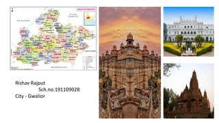
- 1. Rishav Rajput Sch.no.191109028 City - Gwalior
- 2. History 1. Gwalior is a major city in the central Indian state of Madhya Pradesh. 2. The earliest historical record found at Gwalior is the Gwalior inscription of the Alchon Hun ruler Mihirakula. 3. Around the 9th century, the Gurjara-Pratihara dynasty controlled Gwalior . 4. In 1375, Raja Veer Singh was made the ruler of Gwalior and he founded the rule of the Tomar clan. 5. Gwalior is also known for not participating in the 1857 rebellion, mainly due to non-co-operation with Rani Lakshmibai. 6. Later in the 1730s, the Scindias captured Gwalior and it remained a princely state during the British Rule. 7. The Scindia state[14] of Gwalior became a major regional power in the second half of the 18th century.
- 3. Geogrpahy Gwalior is located at 26.22° North Latitude and 78.18° East Longitude, in the state of Madhya Pradesh . The average elevation of the land of Gwalior is about 197 meters above the sea level. Spread over an area of 5214.00 sq km, in the Chambal river valley, the city of Gwalior is landlocked on all sides.
- 4. Demographic Character ❑ As of 2011's India census, Gwalior had a population of 1,069,276. ❑ Males constitute 53% of the population and females 47%. ❑ Gwalior has an average literacy rate of 84.14%, higher than the national average of 74%: male literacy is 89.64% and female literacy is 77.92 %. ❑ In Gwalior 13 % of population under 12 years of age.
- 5. CLIMATE • Gwalior has a sub-tropical climate with hot summers from late March to early July, the humid monsoon season from late June to early October, and a cool dry winter from early November to late February. Under Köppen's climate classification the city has a humid subtropical climate. The highest recorded temperature was 49 °C and the lowest was −1 °C. Summers start in late March, and along with other cities like Jaipur and Delhi, are among the hottest in India and the world. Temperatures peak in May and June with daily averages being around 33– 35 °C.
- 6. Population
- 7. Road, Rail and Air Infrastructure The city is well connected via rail, road and air transport services. ❑Airport Gwalior Airport connects Gwalior directly to Delhi and Bhopal in India with Deccan airlines operating on these routes. This airport has good infrastructure and facilities. ❑Railways Gwalior is one of the major commercial railway station of North-Central railway. Gwalior is, perhaps, one of the only few places where there are both narrow gauge and broad gauge railways tracks are still operational. A unique aspect about gwalior narrow gauge is that, the width of the track is smallest among all the narrow gauges tracks in India. Gwalior is well connected via train services to all parts of the country including 4 metros. There are direct trains to Mumbai, Delhi, Kolkata (Howrah), Chennai, Trivandru.
- 8. Socio-economy ❑ Gwalior economy is based on the industries housed in the territory. Gwalior is known to be the industrial base that is largely supporting the economy at Gwalior. In fact, the industries of Gwalior are recognized as the counter magnet to the industries of National Capital Region. It is noteworthy that the industries of Gwalior are emerging as integrated industrial estates. These industrial estates of Gwalior are run by the development corporations that are large working towards the proliferation of these industries. The independent industrial development corporations are thus contributing towards the expansion of the economy of Gwalior. Moreover, it is noteworthy that the industrial estates of Gwalior possesses all the facilities that are required for the development of the industries of Gwalior. In fact, these existing industrial areas are said to be instrumental in the development of the industries in Gwalior. Some of the industries that form an integral part of Gwalior economy are: •Textile mills •Artificial silk manufacturing plants •Handicraft and hand loom industry •Tanning industry •Chemical industry
- 9. Jai Vilas Palace ➢The Jai Vilas Palace was constructed in 1874 by Jayajirao Scindia of the Maratha Scindia Dynasty, the then Maharaja of Gwalior. ➢The majestic palace was built to extend a grand welcome to the then Prince of Wales, King Edward VII, for his visit in 1875. ➢The Jai Vilas Palace is a splendid portrayal of European architecture. Designed by the famous architect Sir Michael Filose. ➢The edifice covers an area of 1,240,771 square feet. ➢ The museum, which is named HH Maharaja Sir Jiwajirao Scindia Museum, was inaugurated on 12th December 1964 by Dr. Sarvapalli Radhakrishnan, the then president of India. ➢Today, the Jai Vilas Palace serves as the royal residence of the Maratha Scindia family’s descendants.
- 10. Image Of Jai Vilas Palace
- 11. Map of Gwalior in 1947
- 12. Map of Gwalior in 1975
- 13. Gwalior Master Plan 2005 Gwalior Master Plan 2005 has been created for Gwalior District. Gwalior is one of the 51 districts of Madhya Pradesh state in central India. Gwalior Metropolitan Region is one of the major metropolitan areas in India. Other cities and towns in this district are Antari, Bhitarwar, Bilaua, Dabra, Morar, Lashkar, Morar Cantonment, Pichhore, and Tekanpur. Gwalior is a major city in the Indian state of Madhya Pradesh and one of the Counter-magnet cities. As of 2011’s India census, Gwalior has a population of 19,53,505. Gwalior Junction is a five railway track intersection point. It won an award for the best and cleanest station of North Central Railway zone. Gwalior is one of the major commercial railway stations of the North Central Railway, whose zonal headquarters is centered in Allahabad.
- 14. Objectives of Gwalior Master Plan 2005 The objective of the Gwalior Master Plan 2005 is to create enabling spatial and land use planning framework to achieve the Vision of Gwalior Master Plan 2005 in order to promote, guide and rationalize. The future growth and development of the urban centres, it will be critical to define their growth framework The future growth framework of the urban centres are defined by the Master Plan/Development Plans which are evolved for each settlement at individual level. Gwalior Master Plan 2005 has been considered as one of the most effective mechanism to promote planned growth of the urban centres. It lays down the road map, agenda and framework within which the city growth is envisioned. It provides a tool for the authorities to take decision with regard to current and future development related issues.
- 15. Gwalior Master Plan 2005 provides the framework for rationalizing the orderly movement of traffic and transportation within the city and defines the area for laying down net-work of various services. The plan is used for promoting integrated development of the urban centre by rationalizing its pattern of land use and their interrelationship. It also defines the strategies and solutions for overcoming the existing problems of the urban centres and to overcome its infrastructural and service related inadequacies. In addition, it provides options for accommodating the future addition to population which is likely to come to the urban centre due to natural growth and migration. Master Plan acts as a tool for determining the infrastructure cost which would be required to make the city sustainable. The plans offer futuristic solutions by laying down agenda for its growth and development.
- 16. Development Goals of Gwalior Master Plan 2005 •Socially beneficial •Regionally connected •Environmentally sustainable •Financially Viable •Institutionally Executable and; •Politically acceptable
- 17. Master plan 2005 Map
- 18. Gwalior Physiography and Wind Direction
- 19. Visual Order
- 20. Gwalior Natural Drainage Map
- 21. Gwalior Natural Heritage Map
- 22. Gwalior Regional Setting Map
- 23. Planning Unit
- 24. Existing Land use Map
- 25. Gwalior Master Plan 2021 ❑Objectives of Gwalior Master Plan 2021 • The objective of the Gwalior Master Plan 2021 is to create enabling spatial and land use planning framework to achieve the Vision of Gwalior Master Plan 2021 in order to promote, guide and rationalize. The future growth and development of the urban centres, it will be critical to define their growth framework The future growth framework of the urban centres are defined by the Master Plan/Development Plans which are evolved for each settlement at individual level. Gwalior Master Plan 2021 has been considered as one of the most effective mechanism to promote planned growth of the urban centres. It lays down the road map, agenda and framework within which the city growth is envisioned. It provides a tool for the authorities to take decision with regard to current and future development related issues.
- 26. • Gwalior Master Plan 2021 provides the framework for rationalizing the orderly movement of traffic and transportation within the city and defines the area for laying down net-work of various services. The plan is used for promoting integrated development of the urban centre by rationalizing its pattern of land use and their interrelationship. It also defines the strategies and solutions for overcoming the existing problems of the urban centres and to overcome its infrastructural and service related inadequacies. In addition, it provides options for accommodating the future addition to population which is likely to come to the urban centre due to natural growth and migration. Master Plan acts as a tool for determining the infrastructure cost which would be required to make the city sustainable. The plans offer futuristic solutions by laying down agenda for its growth and development.
- 27. ❑Development Goals of Gwalior Master Plan 2021 • Socially beneficial • Regionally connected • Environmentally sustainable • Financially Viable • Institutionally Executable and; • Politically acceptable
- 28. Master Plan 2021 Map
- 29. Some Past and Present Images of Gwalior