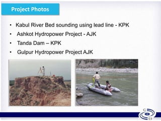
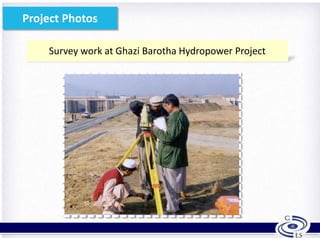
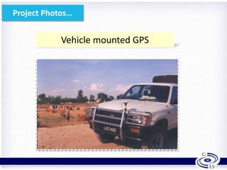
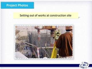
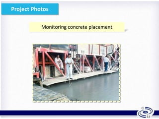
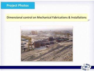
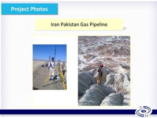
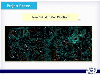
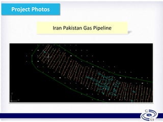
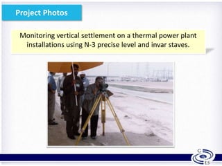
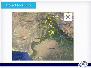
Chartered Land Surveyors & Engineers
What we Think..!!
Solutions Provided
• Land & Hydrographic Surveying
• Terrestrial mapping of architectural sites
• Engineering & Construction Projects Surveying and
Mapping
• Dimensional control on mechanical installations
• Cadastral Surveying
• Deformation monitoring
Services Provided
4
• Geomatics
• Civil Engineering Consulting
• Project Management
• Architectural
• Highway/Road Design
• Airport Engineering
• Geotechnical Engineering
• GIS
• Photogrammetry
• Housing Schemes
• Computer Aided Drafting
• Construction Supervision
GPS Control Survey Projects
• Gabral Kalam Hydropower Project (Swat) – KPK
• Shagarthang Hydropower Project – Gilgit Baltistan
• Power Transmission Line – Neelum Jhelum HPP to Rawat
to Ghakhar Sub-Stations - 335 Km. Punjab & AJK
• Bostan-Zob Railways – 295 Km.- Balochistan
• Azad Pattan Hydropower Project – AJK
5
GPS Control Survey Projects
• Sarkand – Moro Powerline Powers Setting out – 100 Km -
Sindh
• Solar Power Plant – Kallar Kahar – 300 acres Topo Survey-
Punjab
• Potohar Climate Change Smart Irrigated Agriculture Project
• 10,000 acres Topo Survey – Punjab
• Iran-Pakistan Gas Pipeline – 800 Km – Balochistan & Sindh
6
• Kabul River Bed sounding using lead line - KPK
• Ashkot Hydropower Project - AJK
• Tanda Dam – KPK
• Gulpur Hydropower Project AJK
7
Project Photos
Project Photos
Survey work at Ghazi Barotha Hydropower Project
8
Project Photos…
9
Vehicle mounted GPS
Setting out of works at construction site
10
Project Photos
Monitoring concrete placement
11
Project Photos
Dimensional control on Mechanical Fabrications & Installations
12
Project Photos
Iran Pakistan Gas Pipeline
13
Project Photos
Iran Pakistan Gas Pipeline
14
Project Photos
Iran Pakistan Gas Pipeline
15
Project Photos
Monitoring vertical settlement on a thermal power plant
installations using N-3 precise level and invar staves.
16
Project Photos
Water Resources & Power Development Projects
• Jinnah Hydropower Project – Mianwali (Punjab)
• Patrind Hydropower Project – AJK & KPK
• Kheyal Kawar Hydropower Project – KPK
• Dasu Hydropower Project – KPK
• Ashkot Hydropower Project – AJK
• Gulpur Hydropower Project –AJK
• Suki Kinari Hydropower Project – AJK
• Shagarthang Hydropower Project – G&B
17
Gas Pipeline Projects
• 6 km – Gas line for Thermal Station – Zam Zama Gas Field
• Establishment of Survey Control along ≈ 800 km Iran –
Pakistan Gas Pipeline Project.
• Topo Survey for Pumping Station
• River and Streams crossing survey for the Gas Pipeline
• Topo Survey of 200 km section of the Iran- Pakistan Gas
Pipeline (200 m wide strip).
18
Survey Instruments
19
Total Stations
• Topcon GPT-3502LN (Reflectorless
up to 2km range) – Japan
• Sokkia Set 530 R – Japan
• Sokkia Set 610 K – Japan
• Sokkia Set 630 R – Japan
• Leica TPC 407 – Swiss
• Nikon DTM 332 – Japan
• DADI - China
Leveling Instruments
• Wild NA – 2 Swiss
• Leica NA – 728
• Sprinter Electronic - Swiss
Theodolites T2 -Swiss
20
Survey Instruments
GPS Dual Frequency Geodetic Class
• Leica GPS 500 Series + RTK - 6 Units
• Leica GPS 1200 Series + RTK - 2 Units
Hand Held GPS
• Magellan SporTrak – 2 Units
• Garmin GPS 12 – 1 Unit
• Magellan Triton – 1 Unit
• Garmin eTrex 30 – 3 Units
• Wild Plane Table + Alidade RK-1
• 6 Persons Rubber Boat – 1
• Echo Sounder – OHMEX (U.K.)
 SonarMite SM 3 – 1 Unit
 SonarMite SM 4 – 1 Unit
 Hand Held Echo Sounder – Japan – 1 Unit
• Lap Top Computer Field Use – 6 units
• HP A-0 Size Plotter Design Jet 500 Series
21
Survey Instruments
22
Project Locations
23
Our Clients
24
for your attention.

Geomatics Introduction

  • 1.
  • 2.
  • 3.
    Solutions Provided • Land& Hydrographic Surveying • Terrestrial mapping of architectural sites • Engineering & Construction Projects Surveying and Mapping • Dimensional control on mechanical installations • Cadastral Surveying • Deformation monitoring
  • 4.
    Services Provided 4 • Geomatics •Civil Engineering Consulting • Project Management • Architectural • Highway/Road Design • Airport Engineering • Geotechnical Engineering • GIS • Photogrammetry • Housing Schemes • Computer Aided Drafting • Construction Supervision
  • 5.
    GPS Control SurveyProjects • Gabral Kalam Hydropower Project (Swat) – KPK • Shagarthang Hydropower Project – Gilgit Baltistan • Power Transmission Line – Neelum Jhelum HPP to Rawat to Ghakhar Sub-Stations - 335 Km. Punjab & AJK • Bostan-Zob Railways – 295 Km.- Balochistan • Azad Pattan Hydropower Project – AJK 5
  • 6.
    GPS Control SurveyProjects • Sarkand – Moro Powerline Powers Setting out – 100 Km - Sindh • Solar Power Plant – Kallar Kahar – 300 acres Topo Survey- Punjab • Potohar Climate Change Smart Irrigated Agriculture Project • 10,000 acres Topo Survey – Punjab • Iran-Pakistan Gas Pipeline – 800 Km – Balochistan & Sindh 6
  • 7.
    • Kabul RiverBed sounding using lead line - KPK • Ashkot Hydropower Project - AJK • Tanda Dam – KPK • Gulpur Hydropower Project AJK 7 Project Photos
  • 8.
    Project Photos Survey workat Ghazi Barotha Hydropower Project 8
  • 9.
  • 10.
    Setting out ofworks at construction site 10 Project Photos
  • 11.
  • 12.
    Dimensional control onMechanical Fabrications & Installations 12 Project Photos
  • 13.
    Iran Pakistan GasPipeline 13 Project Photos
  • 14.
    Iran Pakistan GasPipeline 14 Project Photos
  • 15.
    Iran Pakistan GasPipeline 15 Project Photos
  • 16.
    Monitoring vertical settlementon a thermal power plant installations using N-3 precise level and invar staves. 16 Project Photos
  • 17.
    Water Resources &Power Development Projects • Jinnah Hydropower Project – Mianwali (Punjab) • Patrind Hydropower Project – AJK & KPK • Kheyal Kawar Hydropower Project – KPK • Dasu Hydropower Project – KPK • Ashkot Hydropower Project – AJK • Gulpur Hydropower Project –AJK • Suki Kinari Hydropower Project – AJK • Shagarthang Hydropower Project – G&B 17
  • 18.
    Gas Pipeline Projects •6 km – Gas line for Thermal Station – Zam Zama Gas Field • Establishment of Survey Control along ≈ 800 km Iran – Pakistan Gas Pipeline Project. • Topo Survey for Pumping Station • River and Streams crossing survey for the Gas Pipeline • Topo Survey of 200 km section of the Iran- Pakistan Gas Pipeline (200 m wide strip). 18
  • 19.
    Survey Instruments 19 Total Stations •Topcon GPT-3502LN (Reflectorless up to 2km range) – Japan • Sokkia Set 530 R – Japan • Sokkia Set 610 K – Japan • Sokkia Set 630 R – Japan • Leica TPC 407 – Swiss • Nikon DTM 332 – Japan • DADI - China Leveling Instruments • Wild NA – 2 Swiss • Leica NA – 728 • Sprinter Electronic - Swiss Theodolites T2 -Swiss
  • 20.
    20 Survey Instruments GPS DualFrequency Geodetic Class • Leica GPS 500 Series + RTK - 6 Units • Leica GPS 1200 Series + RTK - 2 Units Hand Held GPS • Magellan SporTrak – 2 Units • Garmin GPS 12 – 1 Unit • Magellan Triton – 1 Unit • Garmin eTrex 30 – 3 Units
  • 21.
    • Wild PlaneTable + Alidade RK-1 • 6 Persons Rubber Boat – 1 • Echo Sounder – OHMEX (U.K.)  SonarMite SM 3 – 1 Unit  SonarMite SM 4 – 1 Unit  Hand Held Echo Sounder – Japan – 1 Unit • Lap Top Computer Field Use – 6 units • HP A-0 Size Plotter Design Jet 500 Series 21 Survey Instruments
  • 22.
  • 23.
  • 24.