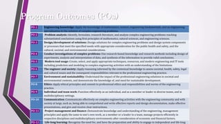
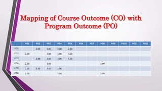
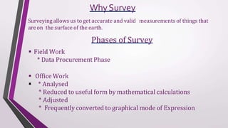
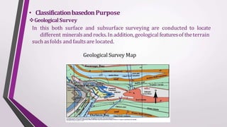
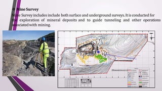
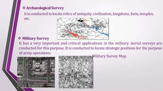
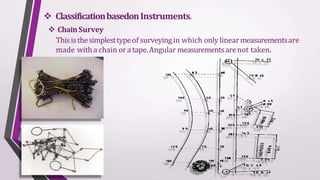
Advanced Surveying
CIV 393
Revised Bloom’s Taxonomy
at surveying
CourseOutcomes: Through the course students should be able to
 Apply the knowledge of geometric principles to arrive
problems.
 Use modern instruments to obtain geo-spatial data and analyze the same to
appropriate engineering problems.
 Analyse geodetic data to process and perform analysis for survey problems
with the use of electronic instruments.
 Understand and implement the different types of curves for deviating type
of alignments.
Program Outcomes (POs)
PO-1 Engineering knowledge::Apply the knowledge of mathematics, science, engineering fundamentals, and an engineering
specialization to the solution of complex engineering problems.
PO-2 Problem analysis::Identify, formulate, research literature, and analyze complex engineering problems reaching
substantiated conclusions using first principles of mathematics, natural sciences, and engineering sciences.
PO-3 Design/development of solutions::Design solutions for complex engineering problems and design system components
or processes that meet the specified needs with appropriate consideration for the public health and safety, and the
cultural, societal, and environmental considerations.
PO-4 Conduct investigations of complex problems::Use research-based knowledge and research methods including design of
experiments, analysis and interpretation of data, and synthesis of the information to provide valid conclusions.
PO-5 Modern tool usage::Create, select, and apply appropriate techniques, resources, and modern engineering and IT tools
including prediction and modeling to complex engineering activities with an understanding of the limitations
PO-6 The engineer and society::Apply reasoning informed by the contextual knowledge to assess societal, health, safety, legal
and cultural issues and the consequent responsibilities relevant to the professional engineering practice.
PO-7 Environment and sustainability::Understand the impact of the professional engineering solutions in societal and
environmental contexts, and demonstrate the knowledge of, and need for sustainable development.
PO-8 Ethics::Apply ethical principles and commit to professional ethics and responsibilities and norms of the engineering
practice.
PO-9 Individual and team work::Function effectively as an individual, and as a member or leader in diverse teams, and in
multidisciplinary settings.
PO-10 Communication::Communicate effectively on complex engineering activities with the engineering community and with
society at large, such as, being able to comprehend and write effective reports and design documentation, make effective
presentations, and give and receive clear instructions.
PO-11 Project management and finance::Demonstrate knowledge and understanding of the engineering, management
principles and apply the same to one’s own work, as a member or a leader in a team, manage projects efficiently in
respective disciplines and multidisciplinary environments after consideration of economic and financial factors.
PO-12 Life-long learning::Recognize the need for, and have the preparation and ability to engage in independent and life-long
PO1 PO2 PO3 PO4 PO5 PO6 PO7 PO8 PO9 PO10 PO11 PO12
CO1 2.00 2.00 3.00 2.00
CO2 2.00 2.00 1.00 3.00
CO3 2.00 2.00 3.00 1.00
CO4 2.00 3.00 2.00
CO5 2.00 3.00 3.00 1.00
CO6 2.00 2.00 2.00
Mapping of Course Outcome (CO) with
Program Outcome (PO)
Course
Specification
 LTP : 3:0:0 Credits : 3
 Text Book : FLUID MECHANICS AND HYDRAULIC MACHINES by Dr.R.K
BANSAL
 CA Structure :
3 Tests:
1 before MTE (3th week)
2 after MTE (9th and 10th week)
▶ L:T:P– 3 : 0 : 0 Credits: 3
▶ Text Book
1. Kanetkar T P and S V Kulkarni, Surveying and Levelling Part 2, Pune Vidyarthi Griha
Prakashan
2. K.R. Arora, “SurveyingVol. 1” Standard Book House, New Delhi.
3. Sateesh Gopi, Global Positioning System, Tata McGraw Hill Publishing Co. Ltd. New
Delhi.
1. S.K. Duggal, “SurveyingVol.I & II”, Tata McGraw Hi ll Publishing Co. Ltd. New Delhi.
2. R Subramanian, Surveying and Leveling, Second edition, Oxford University Press, New
Delhi.
3. DavidClerk, Plane and Geodetic SurveyingVol1 andVol2, CBS publishers.
4. B Bhatia, Remote Sensing and GIS , Oxford University Press, New Delhi.
5. T.M Lillesand,. R.W Kiefer,. and J.W Chipman, Remote sensing and Image
interpretation, 5th edition, John Wiley and Sons India
6. B.C. Punmia, “SurveyingVol.2”, Laxmi Publications pvt. Ltd., New Delhi.
Unit 1
Tacheometric Surveying: Introduction, purpose, principle, instruments, stadia constants, methods
of tacheometry, anallatic lens, subtense bar, field work in tacheometry, reduction of readings, errors
and precisions.
Geodetic Surveying: Principle and Classification of triangulation system, Selection of base line
and stations, Orders of triangulation, Triangulation figures, Station marks and signals, marking
signals, Extension of base, Reduction of Centre, Selection and marking of stations.
Unit 2
Theory of Errors: Introduction, types of errors, definitions, laws of accidental errors, laws of
weights, theory of least squares, rules for giving weights and distribution of errors to the field
observations, determination of the most probable values of quantities.
Unit 3
Field Astronomy: Introduction, purposes, astronomical terms, determination of azimuth, latitude,
longitude and time corrections to the observations.
Aerial photogrammetry: Introduction, Principle, Uses, Aerial camera, Aerial photographs,
Definitions, Scale of vertical and tilted photograph, Ground Co-ordinates, Displacements and
errors, Ground control, Procedure of aerial survey, Photomaps and mosaics, Stereoscopes, Parallax
bar.
Unit 4
Modern Surveying Instruments: Introduction, Electromagnetic spectrum, Electromagnetic
distance measurement, Total station, Digital self-leveling levels, scanners for topographical survey.
Unit 5
Remote Sensing: Introduction, Principles of energy interaction in atmosphere and earth surface
features, Image interpretation techniques, visual interpretation, Digital image processing, Global
Positioning system.
Unit 6
Geographical Information System: Definition of GIS, Key Components of GIS, Functions of
GIS, Spatial data, spatial information system Geospatial analysis, Integration of Remote sensing
and GIS, Applications in Civil Engineering.
Surveying
•Surveying is the science and art of determining the
relative positions of points above, on, or beneath the
earth’s surface and locating the points in the field.
WhySurvey
Surveying allows us to get accurate and valid measurements of things that
are on the surface of the earth.
Phases of Survey
 Field Work
* Data Procurement Phase
 Office Work
 * Analysed
* Reduced to useful form by mathematical calculations
* Adjusted
* Frequently converted to graphical mode of Expression
PRIMARY DIVISIONS OF
SURVEYING
1.PlainSurveying
2.GeodeticSurveying
• The plain surveying is that type of surveying in which earth
surface is considered as a plane and the curvature of the earth is
ignored. In such surveying a line joining any two stations is
considered to be straight. The triangle formed by any three points
is considered as a plane triangle, and the angles of the triangle
are considered as plain angles.
• Surveying is carried out for a small area of less than 250 km2 . It is
carried out by local or state agencies like R & B department,
irrigation department, railway department.
PlainSurveying
PLAINSURVEYINGEXAMPLE
GEODETICSURVEYING
• The geodetic surveying is that type of surveying in which the
curvature of the earth is takeninto account.
• It is generally extended over larger areas. the line joining any two
stations is considered as curved line.
• The triangle formed by any three points is considered to be spherical
and the angles of the triangle are considered tobe spherical angles.
• Geodetic surveying is conducted by the survey of India department
and is carried out for a larger area exceeding 250 km2
GEODETICSURVEYINGEXAMPLE
DifferenceBetweenPlainSurveying&GeodeticSurveying
No. PlainSurveying GeodeticSurveying
1 Theearthsurface isconsideredasplainSurface. Theearthsurface isconsideredasCurvedSurface.
2. TheCurvature of theearthis ignored Thecurvatureof earthistakeninto account.
3 Linejoining any twostationsisconsideredtobe
straight
Theline joining any twostationsisconsideredas spherical.
4. Thetriangle formed byany threepointsis
consideredas plain
TheTriangleformed byany threepointsisconsideredas
spherical.
5. Theanglesof triangle areconsideredasplain
angles.
Theanglesof thetriangle areconsideredasspherical
angles.
6. Carried outfor a small area< 250km2 Carried outfor a small area> 250km2
CLASSIFICATIONOF SURVEYING
Surveycan beclassifiedinto variouscategories dependingon
methodsused andnatureof thefield, basedon Purpose&Basedon
Instruments
• ClassificationbasedonNatureof field
LandSurvey
LandSurveyisdoneon land toprepareplan and mapsof a given area.
Topographical, city andcadastralsurveysaresomeof theexamplesof land
surveying
Land Survey Maps
 Hydrological Surveying
Thissurveyisconducted on ornearthebodyof watersuch aslake,river,
coastalarea. ThisSurveyconsistsof locating shorelinesof waterbodies.
Hydrological Maps
 AstronomicalSurvey
Thissurvey isconducted for thedeterminingof latitudes, longitudes,azimuths,
local time,etc. for variousplaces on earthbyobservingheavenlybodies(sun or
the stars).
AerialSurvey
An aerial survey is conducted from aircraft. Aerial cameras take photographs
of the surface of the earth in overlapping strips of land. This is also known as
photographic survey.
Aerial Survey Map
• ClassificationbasedonPurpose
GeologicalSurvey
In this both surface and subsurface surveying are conducted to locate
different mineralsand rocks.In addition, geological featuresof theterrain
such asfolds and faultsare located.
Geological Survey Map
 MineSurvey
Mine Surveyincludes include bothsurface and underground surveys.Itisconducted for
the exploration of mineral deposits and to guide tunneling and other operations
associatedwith mining.
W A ST E D U M P
MN
A B
C
D
E
F
G
H
I
J
K
L
M
I NDEX
PHOTOGRAPHS OF THE GROUND CONTROLPOINTS
CO- ORDINAT E S OF GROUNDCONTROL POINTS
N 10°50'52" E076°49' 53"
10°50' 45"E076°50' 30"
GCP-1 GCP-2 GCP-3
M.L.Boundary
7.5mSafetyZone
Workings
Contours
Nallah
Canal
WasteDump
RetainingWall
WaterGarland Drain
Core BoreHoles
Statutorybuildings
RopeWayLine
66 K.VPowerLine
ExistingPlantation
MineApproach
Roads
CHECKBUND
GPSCO- ORDINATESOFBOUNDARYPOINTS
B OU ND ARY LAT IT UDE LONGITU DE B OU ND ARY LAT IT UDE LONGITU DE P ILLARS P ILLARS
A N 10°51'34. 0 0" E076 °45'53. 00" H N 10°51'21. 0 0" E076 °46'47. 00"
B N 10°51'34. 0 0" E076 °46'06. 00" I N 10°51'09. 0 0" E076 °46'40. 00"
N 10°51'08 0 0" E07 6°46 00. 00"
C N 10°51'44. 0 0" E076 °46'06. 00" J
D N 10°51'47. 0 0" E076 °46'22. 00" K
N10°51'13. 00" E07 6°46'00. 00"
E N 10°51'47. 0 0" E076 °47'24. 00" L N10°51'13. 00" E07 6°45'48. 00"
F N 10°51'39. 00" E07 6°47'24. 00" M N 10°51'23. 0 0" E07 6°45'51. 00"
G N 10°51'21. 0 0" E076 °47'06. 00"
G CP-2
G CP-1
G CP-3
456HFL HighFloodLevel
Crushing &
Screening Plant
BH-2(II)
D-150.00
EXPLOSIVE
MAGAZINE
ArchaeologicalSurvey
Itisconducted tolocate relics of antiquity,civilization, kingdoms, forts,temples,
etc.
 MilitarySurvey
It has a very important and critical applications in the military. Aerial surveys are
conducted for this purpose. It is conducted to locate strategic positions for the purpose
of army operations.
Military Survey Map
 ClassificationbasedonInstruments.
 ChainSurvey
Thisisthesimplesttypeof surveyingin which only linearmeasurementsare
made witha chain ora tape.Angular measurementsarenot taken.
CompassSurvey
In CompassSurvey,theangles aremeasuredwiththehelp of a magnetic compass
Chainandcompasssurvey:
In this survey linear measurementsare made with a chain or a tape and
angular measurementswith a compass.
PlaneTableSurveying
Itisa graphical methodof surveyingin which field worksand plottingbotharedone
simultaneously.
TheodoliteSurvey
In theodolite survey thehorizontalangles are measured with thetheodolite more
preciselythan compassand thelinearmeasurementsaremadewith a chain ortape
 TachometrySurvey
A special typeof theodoliteknown astachometerisusedtodeterminehorizontaland
verticaldistances indirectly
LevelingSurvey
This type of survey is used to determine the vertical distances (elevations) and
relative heights of pointswiththehelp of an instrumentknown aslevel.
PhotogrammetricSurvey
Photogrammetryisthescience of taking measurementswiththehelp of photographs
takenbyaerialcamera from theair craft.
co-ordinates) aremade
 EDM (ElectronicDistanceMeasurement)Survey
In this type of survey all measurements ( length, angles,
with thehelp of EDM instrument(i.e.. Total Station).
 GPS(GlobalPositioningSystems)Survey
GPS was rapidly adapted for surveying, as it can give a position (Latitude,
Longitude and Height) directly, without the need to measure angles and
distances between intermediate points. Survey control could now be
established almost anywhere and it was only necessary to have a clear view
of the sky so the signal from the GPS satellites could be receivedclearly.
 DGPS(DifferentialGlobalPositioningSystems)Survey
This Type of Surveys Which Are Carried Out Using The Differential GPS. It Achieves Higher
Positional Accuracy By Making Use Of The Differential Capabilities Of Two Or More GPS Antenna
Linked By A Radio Signal.
ClassificationBasedonmethods.
 Triangulation
Triangulationisbasic method of surveying, when theareatobesurveyedislarge,
triangulation is adopted. The entire area is divided into network of triangles.
Traversing
A Traversing is circuit of survey lines. It may be open or closed. When the linear
measurements are done with a chain and a tape and the directions or horizontal
angles are measured with a compass or a theodolite respectively the survey is called
traversing.
Open Traversing Map Closed Traversing Map
Advanced surveying
equipments
• Electronic Theodolite
• EDM – Electronic distance measurement eqp.
• Auto Level.
• Digital Level.
• Laser Level.
• Laser Distance meter
• T
otal station.
• GPS – global positioning system.
1.Electronic Thoedolite
• For precise surveys the vernier theodolites are
replaced by modern theodolites such as optical
and electronic theodolites.
• The electronic theodolites have optical
system to scan both horizontal and vertical
circles and display them digitally on a screen
2. EDM (Electronic Distance
meter)
1. EDM is Electronic Distance meter
2. Measurement of distance is done by a
modulated microwave or infrared
carrier signal
3. The distance is determined by emitting
and receiving multiple frequencies, and
determining the integer number of
wavelengths to the target for each
frequency.
3. Auto Level
• Now most commonly used levelling instruments are - Auto level.
• Auto level, as name sounds it has a auto level compensator and
corrects automatically if instrument goes out of level within it’s
range.
• With auto level:-
1. Survey work can be done fast,
2. Less chances of error,
3. Magnification available is more,
4. Range is more,
5. Image is erect so less chances of error.
4. Digital Level
• They are not popular instead auto levels are more
extensively used.
• The Trimble DiNi Digital Level : Determine accurate
height information 60% faster than with automatic
leveling
• Eliminate errors and reduce reworkwith digital
readings
• Transferdata to the office easily
• Measure to a field ofjust 30 cm
5. Laser Level
• The word laser is an acronym for Light Amplification
by Stimulated Emission of Radiation and is the name
applied to an intense beam of highly monochromatic,
coherent light.
• Laser rangefinders use these relationships to
calculate Distance
• Distance = speed of light * (time/2)
• The time refers to time of pulse to go from the
instrument to the tree and back again
• Byusing this Laser distance meter wecan
calculate the distance, area and volume
accurately
• We can use this in night also
6. GPS – Global Positioning
System.
What isGPS?
🠶 GPS, which stands forGlobal PositioningSystem, is
the only system today able to show you your exact
position on the Earth anytime, in any weather,
anywhere.
🠶 Global PositioningSystem –A network of satellites
(24 total – 21 in use, 3 spares) that continuously
transmit coded information which makes it
possible to precisely identify locations on earth by
measuring distance from the satellites.
7.EDM + Theodolite
• EDM is used to measure the horizontal
distances.
• Some EDM are attached with electronics
theodolite which has the adapter system.
• Some are advanced models which itself reads the
distance without theodolite
8.T
otal Station
• A Totalstation integrates the functions of a
Electronic theodolite for measuring angles,
an EDM for measuring distances, digital data
and a data recorder
• Angles and distances, coordinates and height
differences and many other items
can be computed, displayed and stored into
internal memory.

zero lecture.pptx

  • 1.
  • 2.
  • 3.
    at surveying CourseOutcomes: Throughthe course students should be able to  Apply the knowledge of geometric principles to arrive problems.  Use modern instruments to obtain geo-spatial data and analyze the same to appropriate engineering problems.  Analyse geodetic data to process and perform analysis for survey problems with the use of electronic instruments.  Understand and implement the different types of curves for deviating type of alignments.
  • 4.
    Program Outcomes (POs) PO-1Engineering knowledge::Apply the knowledge of mathematics, science, engineering fundamentals, and an engineering specialization to the solution of complex engineering problems. PO-2 Problem analysis::Identify, formulate, research literature, and analyze complex engineering problems reaching substantiated conclusions using first principles of mathematics, natural sciences, and engineering sciences. PO-3 Design/development of solutions::Design solutions for complex engineering problems and design system components or processes that meet the specified needs with appropriate consideration for the public health and safety, and the cultural, societal, and environmental considerations. PO-4 Conduct investigations of complex problems::Use research-based knowledge and research methods including design of experiments, analysis and interpretation of data, and synthesis of the information to provide valid conclusions. PO-5 Modern tool usage::Create, select, and apply appropriate techniques, resources, and modern engineering and IT tools including prediction and modeling to complex engineering activities with an understanding of the limitations PO-6 The engineer and society::Apply reasoning informed by the contextual knowledge to assess societal, health, safety, legal and cultural issues and the consequent responsibilities relevant to the professional engineering practice. PO-7 Environment and sustainability::Understand the impact of the professional engineering solutions in societal and environmental contexts, and demonstrate the knowledge of, and need for sustainable development. PO-8 Ethics::Apply ethical principles and commit to professional ethics and responsibilities and norms of the engineering practice. PO-9 Individual and team work::Function effectively as an individual, and as a member or leader in diverse teams, and in multidisciplinary settings. PO-10 Communication::Communicate effectively on complex engineering activities with the engineering community and with society at large, such as, being able to comprehend and write effective reports and design documentation, make effective presentations, and give and receive clear instructions. PO-11 Project management and finance::Demonstrate knowledge and understanding of the engineering, management principles and apply the same to one’s own work, as a member or a leader in a team, manage projects efficiently in respective disciplines and multidisciplinary environments after consideration of economic and financial factors. PO-12 Life-long learning::Recognize the need for, and have the preparation and ability to engage in independent and life-long
  • 5.
    PO1 PO2 PO3PO4 PO5 PO6 PO7 PO8 PO9 PO10 PO11 PO12 CO1 2.00 2.00 3.00 2.00 CO2 2.00 2.00 1.00 3.00 CO3 2.00 2.00 3.00 1.00 CO4 2.00 3.00 2.00 CO5 2.00 3.00 3.00 1.00 CO6 2.00 2.00 2.00 Mapping of Course Outcome (CO) with Program Outcome (PO)
  • 6.
    Course Specification  LTP :3:0:0 Credits : 3  Text Book : FLUID MECHANICS AND HYDRAULIC MACHINES by Dr.R.K BANSAL  CA Structure : 3 Tests: 1 before MTE (3th week) 2 after MTE (9th and 10th week)
  • 7.
    ▶ L:T:P– 3: 0 : 0 Credits: 3 ▶ Text Book 1. Kanetkar T P and S V Kulkarni, Surveying and Levelling Part 2, Pune Vidyarthi Griha Prakashan 2. K.R. Arora, “SurveyingVol. 1” Standard Book House, New Delhi. 3. Sateesh Gopi, Global Positioning System, Tata McGraw Hill Publishing Co. Ltd. New Delhi. 1. S.K. Duggal, “SurveyingVol.I & II”, Tata McGraw Hi ll Publishing Co. Ltd. New Delhi. 2. R Subramanian, Surveying and Leveling, Second edition, Oxford University Press, New Delhi. 3. DavidClerk, Plane and Geodetic SurveyingVol1 andVol2, CBS publishers. 4. B Bhatia, Remote Sensing and GIS , Oxford University Press, New Delhi. 5. T.M Lillesand,. R.W Kiefer,. and J.W Chipman, Remote sensing and Image interpretation, 5th edition, John Wiley and Sons India 6. B.C. Punmia, “SurveyingVol.2”, Laxmi Publications pvt. Ltd., New Delhi.
  • 8.
    Unit 1 Tacheometric Surveying:Introduction, purpose, principle, instruments, stadia constants, methods of tacheometry, anallatic lens, subtense bar, field work in tacheometry, reduction of readings, errors and precisions. Geodetic Surveying: Principle and Classification of triangulation system, Selection of base line and stations, Orders of triangulation, Triangulation figures, Station marks and signals, marking signals, Extension of base, Reduction of Centre, Selection and marking of stations. Unit 2 Theory of Errors: Introduction, types of errors, definitions, laws of accidental errors, laws of weights, theory of least squares, rules for giving weights and distribution of errors to the field observations, determination of the most probable values of quantities.
  • 9.
    Unit 3 Field Astronomy:Introduction, purposes, astronomical terms, determination of azimuth, latitude, longitude and time corrections to the observations. Aerial photogrammetry: Introduction, Principle, Uses, Aerial camera, Aerial photographs, Definitions, Scale of vertical and tilted photograph, Ground Co-ordinates, Displacements and errors, Ground control, Procedure of aerial survey, Photomaps and mosaics, Stereoscopes, Parallax bar. Unit 4 Modern Surveying Instruments: Introduction, Electromagnetic spectrum, Electromagnetic distance measurement, Total station, Digital self-leveling levels, scanners for topographical survey.
  • 10.
    Unit 5 Remote Sensing:Introduction, Principles of energy interaction in atmosphere and earth surface features, Image interpretation techniques, visual interpretation, Digital image processing, Global Positioning system. Unit 6 Geographical Information System: Definition of GIS, Key Components of GIS, Functions of GIS, Spatial data, spatial information system Geospatial analysis, Integration of Remote sensing and GIS, Applications in Civil Engineering.
  • 11.
    Surveying •Surveying is thescience and art of determining the relative positions of points above, on, or beneath the earth’s surface and locating the points in the field.
  • 12.
    WhySurvey Surveying allows usto get accurate and valid measurements of things that are on the surface of the earth. Phases of Survey  Field Work * Data Procurement Phase  Office Work  * Analysed * Reduced to useful form by mathematical calculations * Adjusted * Frequently converted to graphical mode of Expression
  • 13.
  • 14.
    • The plainsurveying is that type of surveying in which earth surface is considered as a plane and the curvature of the earth is ignored. In such surveying a line joining any two stations is considered to be straight. The triangle formed by any three points is considered as a plane triangle, and the angles of the triangle are considered as plain angles. • Surveying is carried out for a small area of less than 250 km2 . It is carried out by local or state agencies like R & B department, irrigation department, railway department. PlainSurveying
  • 15.
  • 16.
    GEODETICSURVEYING • The geodeticsurveying is that type of surveying in which the curvature of the earth is takeninto account. • It is generally extended over larger areas. the line joining any two stations is considered as curved line. • The triangle formed by any three points is considered to be spherical and the angles of the triangle are considered tobe spherical angles. • Geodetic surveying is conducted by the survey of India department and is carried out for a larger area exceeding 250 km2
  • 17.
  • 19.
    DifferenceBetweenPlainSurveying&GeodeticSurveying No. PlainSurveying GeodeticSurveying 1Theearthsurface isconsideredasplainSurface. Theearthsurface isconsideredasCurvedSurface. 2. TheCurvature of theearthis ignored Thecurvatureof earthistakeninto account. 3 Linejoining any twostationsisconsideredtobe straight Theline joining any twostationsisconsideredas spherical. 4. Thetriangle formed byany threepointsis consideredas plain TheTriangleformed byany threepointsisconsideredas spherical. 5. Theanglesof triangle areconsideredasplain angles. Theanglesof thetriangle areconsideredasspherical angles. 6. Carried outfor a small area< 250km2 Carried outfor a small area> 250km2
  • 20.
    CLASSIFICATIONOF SURVEYING Surveycan beclassifiedintovariouscategories dependingon methodsused andnatureof thefield, basedon Purpose&Basedon Instruments • ClassificationbasedonNatureof field LandSurvey LandSurveyisdoneon land toprepareplan and mapsof a given area. Topographical, city andcadastralsurveysaresomeof theexamplesof land surveying Land Survey Maps
  • 21.
     Hydrological Surveying Thissurveyisconductedon ornearthebodyof watersuch aslake,river, coastalarea. ThisSurveyconsistsof locating shorelinesof waterbodies. Hydrological Maps
  • 22.
     AstronomicalSurvey Thissurvey isconductedfor thedeterminingof latitudes, longitudes,azimuths, local time,etc. for variousplaces on earthbyobservingheavenlybodies(sun or the stars).
  • 23.
    AerialSurvey An aerial surveyis conducted from aircraft. Aerial cameras take photographs of the surface of the earth in overlapping strips of land. This is also known as photographic survey. Aerial Survey Map
  • 24.
    • ClassificationbasedonPurpose GeologicalSurvey In thisboth surface and subsurface surveying are conducted to locate different mineralsand rocks.In addition, geological featuresof theterrain such asfolds and faultsare located. Geological Survey Map
  • 25.
     MineSurvey Mine Surveyincludesinclude bothsurface and underground surveys.Itisconducted for the exploration of mineral deposits and to guide tunneling and other operations associatedwith mining. W A ST E D U M P MN A B C D E F G H I J K L M I NDEX PHOTOGRAPHS OF THE GROUND CONTROLPOINTS CO- ORDINAT E S OF GROUNDCONTROL POINTS N 10°50'52" E076°49' 53" 10°50' 45"E076°50' 30" GCP-1 GCP-2 GCP-3 M.L.Boundary 7.5mSafetyZone Workings Contours Nallah Canal WasteDump RetainingWall WaterGarland Drain Core BoreHoles Statutorybuildings RopeWayLine 66 K.VPowerLine ExistingPlantation MineApproach Roads CHECKBUND GPSCO- ORDINATESOFBOUNDARYPOINTS B OU ND ARY LAT IT UDE LONGITU DE B OU ND ARY LAT IT UDE LONGITU DE P ILLARS P ILLARS A N 10°51'34. 0 0" E076 °45'53. 00" H N 10°51'21. 0 0" E076 °46'47. 00" B N 10°51'34. 0 0" E076 °46'06. 00" I N 10°51'09. 0 0" E076 °46'40. 00" N 10°51'08 0 0" E07 6°46 00. 00" C N 10°51'44. 0 0" E076 °46'06. 00" J D N 10°51'47. 0 0" E076 °46'22. 00" K N10°51'13. 00" E07 6°46'00. 00" E N 10°51'47. 0 0" E076 °47'24. 00" L N10°51'13. 00" E07 6°45'48. 00" F N 10°51'39. 00" E07 6°47'24. 00" M N 10°51'23. 0 0" E07 6°45'51. 00" G N 10°51'21. 0 0" E076 °47'06. 00" G CP-2 G CP-1 G CP-3 456HFL HighFloodLevel Crushing & Screening Plant BH-2(II) D-150.00 EXPLOSIVE MAGAZINE
  • 26.
    ArchaeologicalSurvey Itisconducted tolocate relicsof antiquity,civilization, kingdoms, forts,temples, etc.  MilitarySurvey It has a very important and critical applications in the military. Aerial surveys are conducted for this purpose. It is conducted to locate strategic positions for the purpose of army operations. Military Survey Map
  • 27.
     ClassificationbasedonInstruments.  ChainSurvey Thisisthesimplesttypeofsurveyingin which only linearmeasurementsare made witha chain ora tape.Angular measurementsarenot taken.
  • 28.
  • 29.
    Chainandcompasssurvey: In this surveylinear measurementsare made with a chain or a tape and angular measurementswith a compass.
  • 30.
    PlaneTableSurveying Itisa graphical methodofsurveyingin which field worksand plottingbotharedone simultaneously.
  • 31.
    TheodoliteSurvey In theodolite surveythehorizontalangles are measured with thetheodolite more preciselythan compassand thelinearmeasurementsaremadewith a chain ortape
  • 32.
     TachometrySurvey A specialtypeof theodoliteknown astachometerisusedtodeterminehorizontaland verticaldistances indirectly
  • 33.
    LevelingSurvey This type ofsurvey is used to determine the vertical distances (elevations) and relative heights of pointswiththehelp of an instrumentknown aslevel.
  • 34.
    PhotogrammetricSurvey Photogrammetryisthescience of takingmeasurementswiththehelp of photographs takenbyaerialcamera from theair craft.
  • 35.
    co-ordinates) aremade  EDM(ElectronicDistanceMeasurement)Survey In this type of survey all measurements ( length, angles, with thehelp of EDM instrument(i.e.. Total Station).
  • 36.
     GPS(GlobalPositioningSystems)Survey GPS wasrapidly adapted for surveying, as it can give a position (Latitude, Longitude and Height) directly, without the need to measure angles and distances between intermediate points. Survey control could now be established almost anywhere and it was only necessary to have a clear view of the sky so the signal from the GPS satellites could be receivedclearly.
  • 37.
     DGPS(DifferentialGlobalPositioningSystems)Survey This Typeof Surveys Which Are Carried Out Using The Differential GPS. It Achieves Higher Positional Accuracy By Making Use Of The Differential Capabilities Of Two Or More GPS Antenna Linked By A Radio Signal.
  • 38.
    ClassificationBasedonmethods.  Triangulation Triangulationisbasic methodof surveying, when theareatobesurveyedislarge, triangulation is adopted. The entire area is divided into network of triangles.
  • 39.
    Traversing A Traversing iscircuit of survey lines. It may be open or closed. When the linear measurements are done with a chain and a tape and the directions or horizontal angles are measured with a compass or a theodolite respectively the survey is called traversing. Open Traversing Map Closed Traversing Map
  • 40.
    Advanced surveying equipments • ElectronicTheodolite • EDM – Electronic distance measurement eqp. • Auto Level. • Digital Level. • Laser Level. • Laser Distance meter • T otal station. • GPS – global positioning system.
  • 42.
    1.Electronic Thoedolite • Forprecise surveys the vernier theodolites are replaced by modern theodolites such as optical and electronic theodolites. • The electronic theodolites have optical system to scan both horizontal and vertical circles and display them digitally on a screen
  • 43.
    2. EDM (ElectronicDistance meter) 1. EDM is Electronic Distance meter 2. Measurement of distance is done by a modulated microwave or infrared carrier signal 3. The distance is determined by emitting and receiving multiple frequencies, and determining the integer number of wavelengths to the target for each frequency.
  • 44.
    3. Auto Level •Now most commonly used levelling instruments are - Auto level. • Auto level, as name sounds it has a auto level compensator and corrects automatically if instrument goes out of level within it’s range. • With auto level:- 1. Survey work can be done fast, 2. Less chances of error, 3. Magnification available is more, 4. Range is more, 5. Image is erect so less chances of error.
  • 45.
    4. Digital Level •They are not popular instead auto levels are more extensively used. • The Trimble DiNi Digital Level : Determine accurate height information 60% faster than with automatic leveling • Eliminate errors and reduce reworkwith digital readings • Transferdata to the office easily • Measure to a field ofjust 30 cm
  • 46.
    5. Laser Level •The word laser is an acronym for Light Amplification by Stimulated Emission of Radiation and is the name applied to an intense beam of highly monochromatic, coherent light. • Laser rangefinders use these relationships to calculate Distance • Distance = speed of light * (time/2) • The time refers to time of pulse to go from the instrument to the tree and back again • Byusing this Laser distance meter wecan calculate the distance, area and volume accurately • We can use this in night also
  • 47.
    6. GPS –Global Positioning System. What isGPS? 🠶 GPS, which stands forGlobal PositioningSystem, is the only system today able to show you your exact position on the Earth anytime, in any weather, anywhere. 🠶 Global PositioningSystem –A network of satellites (24 total – 21 in use, 3 spares) that continuously transmit coded information which makes it possible to precisely identify locations on earth by measuring distance from the satellites.
  • 51.
    7.EDM + Theodolite •EDM is used to measure the horizontal distances. • Some EDM are attached with electronics theodolite which has the adapter system. • Some are advanced models which itself reads the distance without theodolite
  • 52.
    8.T otal Station • ATotalstation integrates the functions of a Electronic theodolite for measuring angles, an EDM for measuring distances, digital data and a data recorder • Angles and distances, coordinates and height differences and many other items can be computed, displayed and stored into internal memory.