Geo_DC Meetup talk: Mapping a marathon
•
0 likes•359 views

This document provides instructions for mapping a marathon using various tools: 1. Use RunKeeper, Strava, or Nike+ to track a run and export the GPS data as a GPX file. Convert the GPX file to a shapefile using ogr2ogr and append multiple runs. 2. Style the tracks in Mapbox or Carto including thin lines for the marathon track and thicker semi-transparent lines for the GPS tracks. 3. Aggregate marathon finisher data by city using Python and publish the results as an interactive map in Mapbox or Carto, with city points sized by number of finishers and colored by average time.

More Related Content
What's hot
What's hot (17)
Similar to Geo_DC Meetup talk: Mapping a marathon
Similar to Geo_DC Meetup talk: Mapping a marathon (10)
Recently uploaded
Recently uploaded (20)
Geo_DC Meetup talk: Mapping a marathon
- 2. Nutrition Stride Challenge Feeling good Fitness Motivation Music Mapping
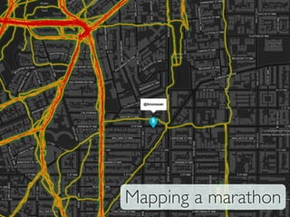
- 3. 1.Run use RunKeeper, Strava, Nike+ (must allow export) 2.Export gpx to shapefile: $ ogr2ogr runs first-‐track.gpx $ ogr2ogr -‐-‐append runs second-‐track.gpx 3.TileMill it 4.Publish in Mapbox
- 4. Carto for Marathon track: - Thin blue Carto for tracks: - Thin opaque red - Thick semi-transparent yellow - THICK very transparent green
- 5. GPS errors contribute to create the circulatory artery scheme
- 6. 20.000+ finishers, with their times, gender, ages, City, ...
- 7. 20.000+ finishers, with their times, gender, ages, City, ...
- 8. 1.Run the Marine Corps Marathon [optional] 2.Import to Google Refine to fix names and geocode (via Yahoo): 3.Aggregate data by city with python [Input]: Places=[r['Location'] for r in runner if 'Location' in r] ... 4.TileMill it 5.Publish in Mapbox
- 9. Carto for cities: -‐ Size ∽ /inishers -‐ Color ∽ time for best 10% -‐ Tooltips with city info
- 10. logging app with export GPS analyze data ~40.000 steps (1 million steps in training) Customize geo data Prepare (geo) data Hosting + map layers geolocation of city names
- 11. Live tracking