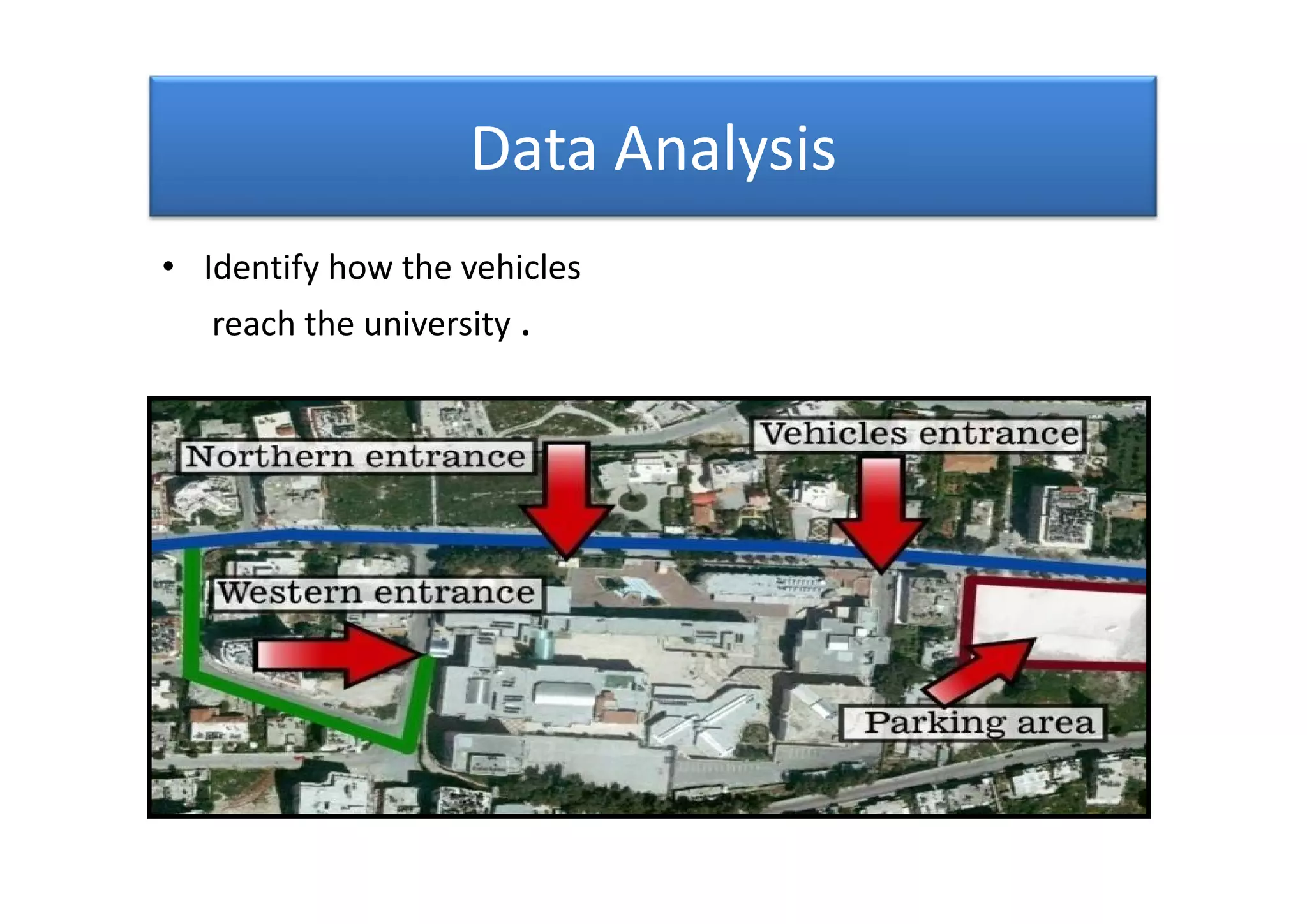
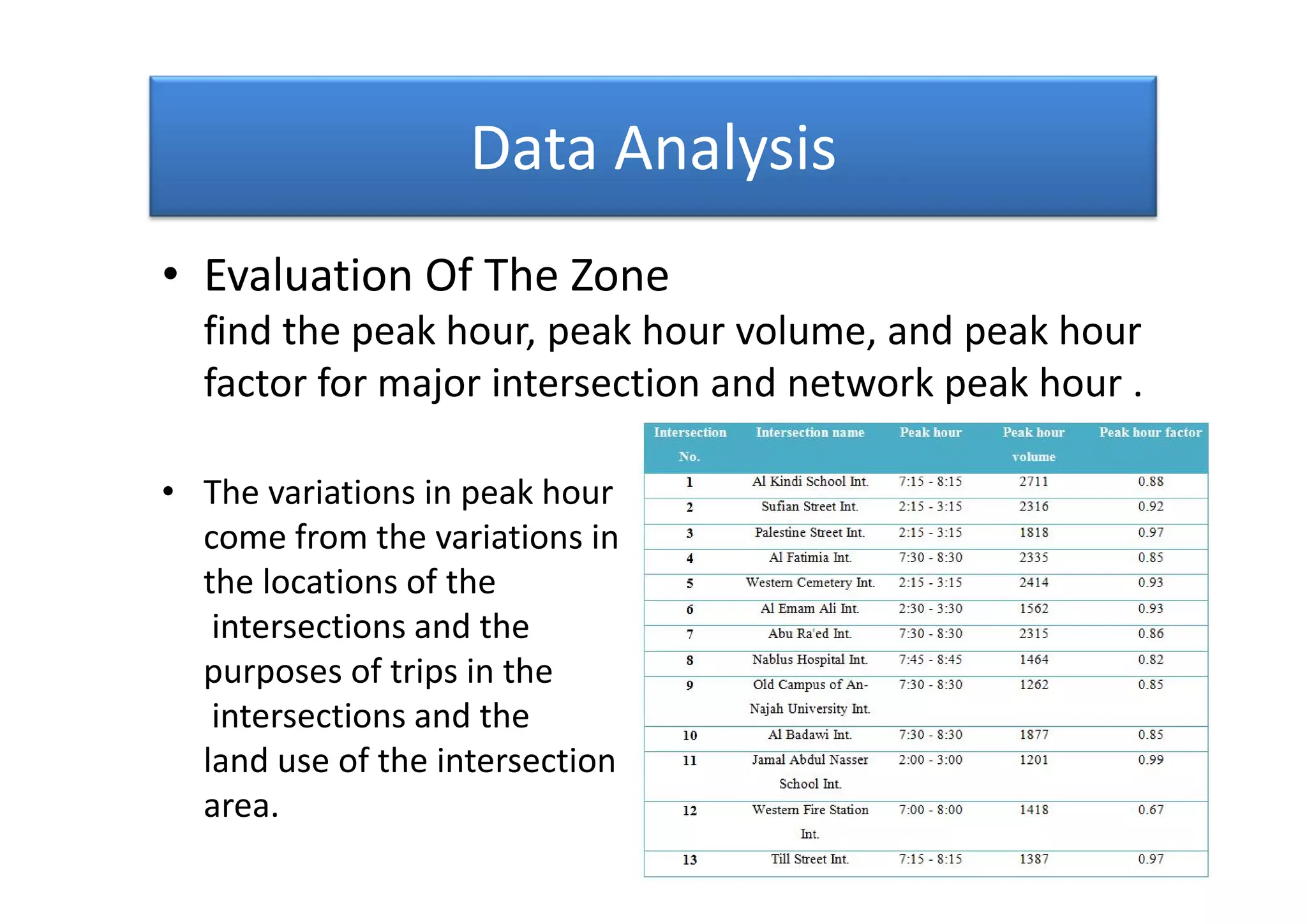
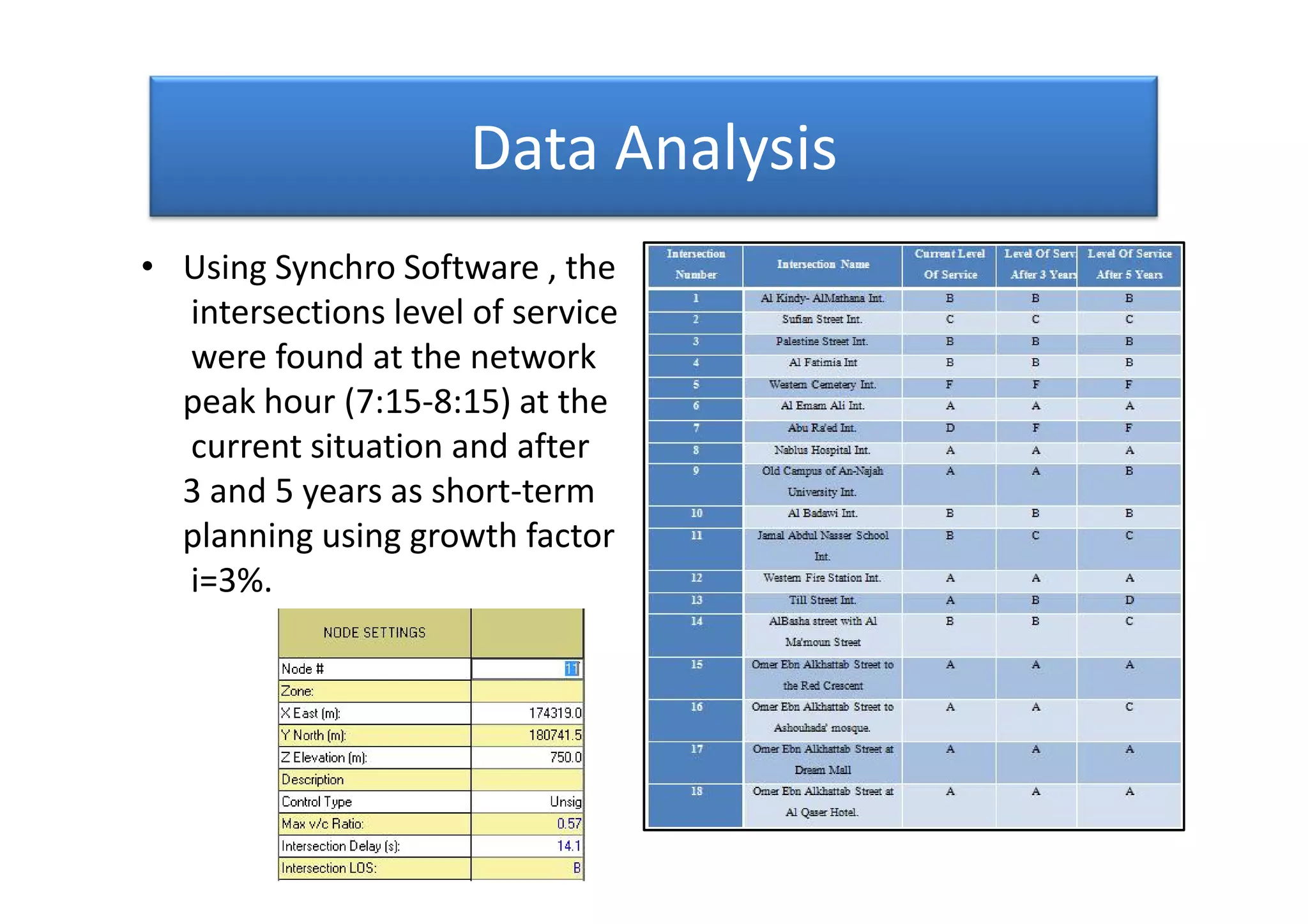
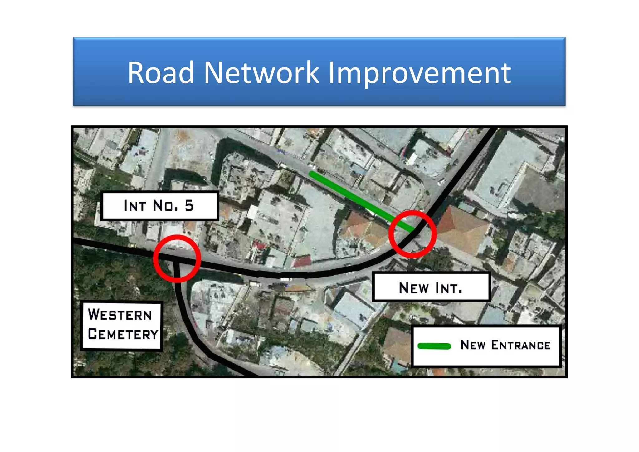
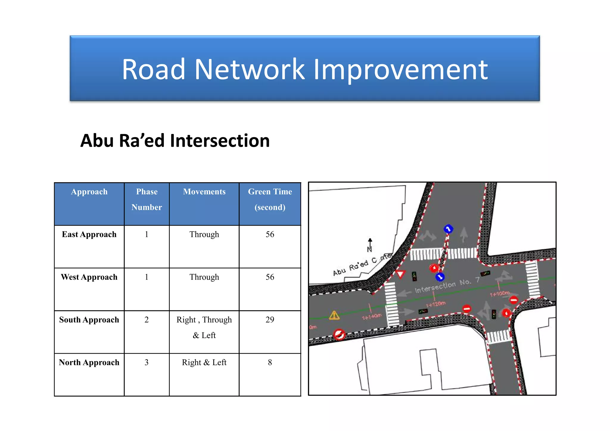
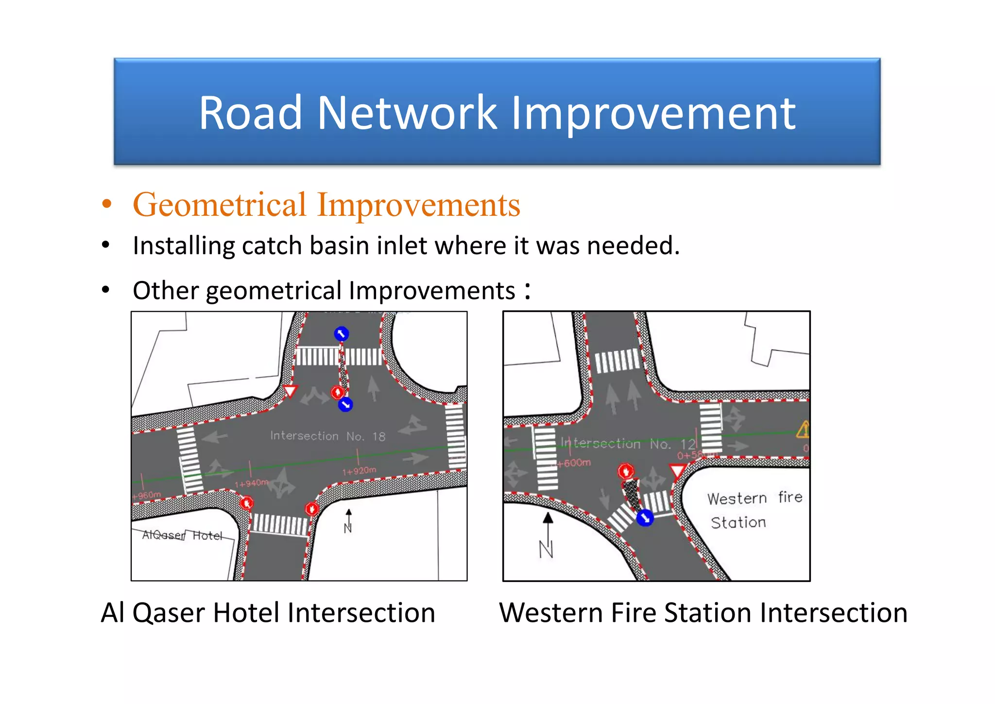
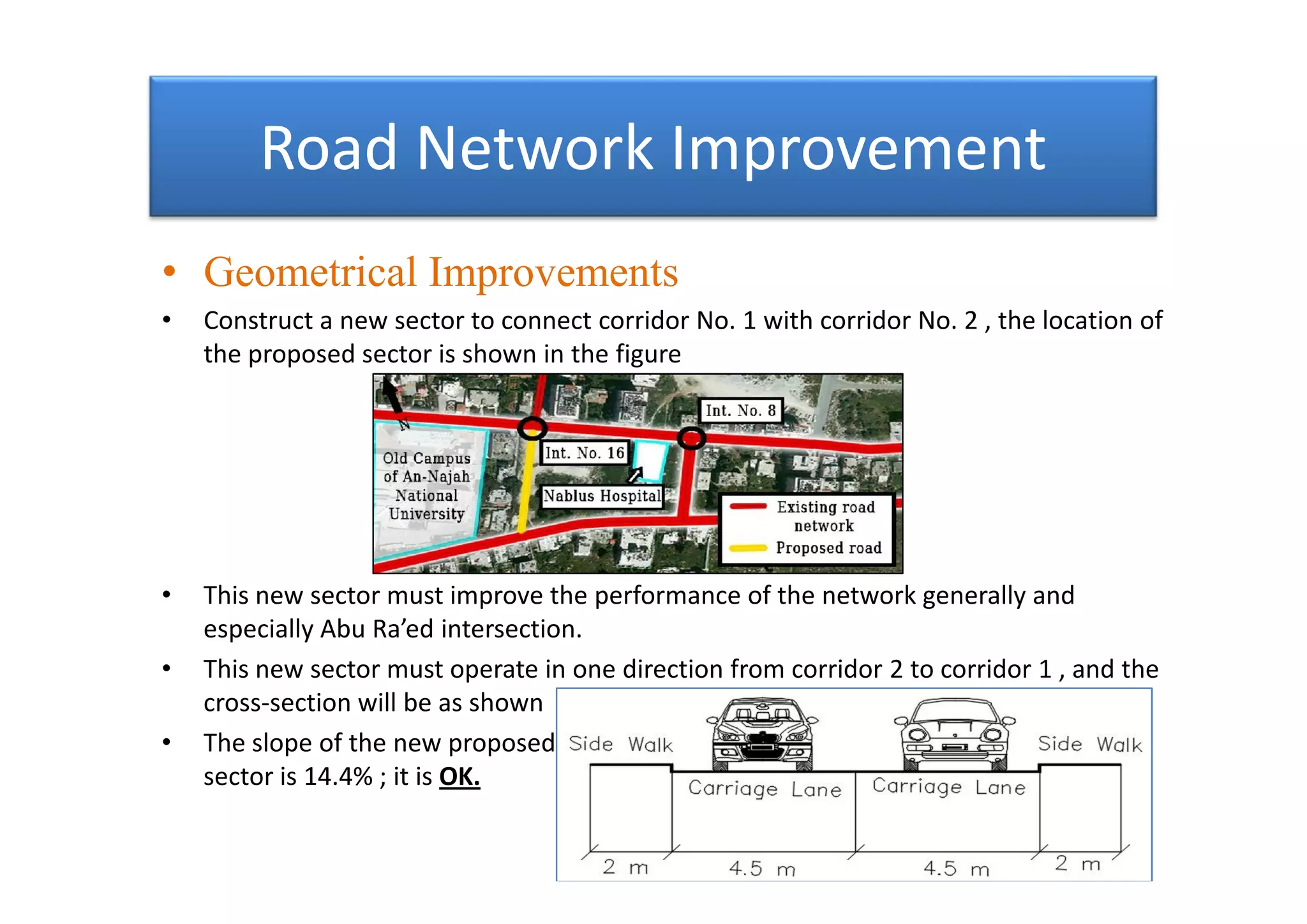
2. Outline
• Introduction
• Methodology
• Geometric Study
• Data collection
• Data Analysis
• Road Network Improvement
• Conclusion and recommendations
• Introduction
• Methodology
• Geometric Study
• Data collection
• Data Analysis
• Road Network Improvement
• Conclusion and recommendations
3. Introduction
• Highway and transportation system is an important sector; it reflects the
extent of the development and urbanization of societies and governorates.
• Nablus Governorate is a very vital governorate in Palestine, the city has a real
importance due its location as an economical and educational center of the
north sector of the West Bank.
• The zone that extends from Al Kindy Secondary School to the old campus of
An-Najah National University then to Al Badawi intersection is an important
corridor.
4. Introduction
• The importance of this zone caused by
1. Existence of the campus of An-Najah National University.
2. The position of the zone that serves Nablus city center.
3. Existence of large hospital in the zone.
• The zone has many problems as :
1. High level of congestion.
2. Long travel time due to the zone ( high delay ).
3. Weaken the public safety.
4. Low level of service for the intersections in the zone.
5. Introduction
• Objective Of The Research
1. Improve the efficiency of existing facilities.
2. Improve safety.
3. Reduce the travel time.
4. Reduce the congestion at intersections.
• Objective Of The Research
1. Improve the efficiency of existing facilities.
2. Improve safety.
3. Reduce the travel time.
4. Reduce the congestion at intersections.
6. Methodology
• Visiting the zone and gathering the data of the geometric conditions and the
traffic control devices.
• Gathering data about the traffic volumes for each intersections in the corridor.
• Network peak hour was found ( 7:15 – 8:15 ).
• Analyzing the data to determine the level of service of the intersections at the
network peak hour.
• Analyzing the data to know the trip distribution, traffic assignment and mode-
split.
• Make improvements for intersections that have unacceptable level of service.
7. Geometric Study
• The length of this corridor 1 is about 2.255
km.
• The length of this corridor 2 is about 1.246
km.
• The length of this corridor 1 is about 2.255
km.
• The length of this corridor 2 is about 1.246
km.
8. Geometric Study
• The lane width ranges from 3.6m to 4.5m.
• The sidewalks range from 0 m to 3.5 m.
• The lane width ranges from 3.6m to 4.5m.
• The sidewalks range from 0 m to 3.5 m.
9. Data collection
• For the major intersections the traffic volume data collect
divided into two parts of the time ( in the morning and in the
evening ) to find the peak hour for the network.
10. Data collection
• For the minor intersections the traffic volume data collected
in the network peak hour.
• For the minor intersections the traffic volume data collected
in the network peak hour.
17. Data Analysis
• Traffic Assignment
The purposes of the trips in the network are :
1. For work.
2. For education.
3. For shopping.
4. For treatment.
5. For social activities.
• Traffic Assignment
The purposes of the trips in the network are :
1. For work.
2. For education.
3. For shopping.
4. For treatment.
5. For social activities.
18. Data Analysis
• Evaluation Of The Zone
find the peak hour, peak hour volume, and peak hour
factor for major intersection and network peak hour .
• The variations in peak hour
come from the variations in
the locations of the
intersections and the
purposes of trips in the
intersections and the
land use of the intersection
area.
19. Data Analysis
• Using Synchro Software , the
intersections level of service
were found at the network
peak hour (7:15-8:15) at the
current situation and after
3 and 5 years as short-term
planning using growth factor
i=3%.
• Using Synchro Software , the
intersections level of service
were found at the network
peak hour (7:15-8:15) at the
current situation and after
3 and 5 years as short-term
planning using growth factor
i=3%.
20. Data Analysis
• The resulted level of service may not accurate;
because of the pedestrian movements It has
not been studied.
21. Road Network Improvement
• After finding the level of service , it was divided into two
parts :
1. Acceptable level of service (A to D).
2. Unacceptable level of service (E and F).
• The improvements should be for intersections that have
Unacceptable level of service after 5 years.
1. Western Cemetery Intersection with LOS F after 5 years.
2. Abu Ra’ed Intersection With LOS F after 5 years.
22. Road Network Improvement
• The main source of accidents at intersection are
the conflict points between the Vehicles path.
• This conflict points are divided into three parts :
1. Merge conflict point.
2. Diverge conflict point.
3. Crossing conflict point.
The most dangerous
• The main source of accidents at intersection are
the conflict points between the Vehicles path.
• This conflict points are divided into three parts :
1. Merge conflict point.
2. Diverge conflict point.
3. Crossing conflict point.
The most dangerous
23. Road Network Improvement
• To improve the geometrical facilities in the zone illegal
parking must be prevented ; because it is waste the
geometrical resources, especially the cross-section element
(reduce the width of traffic lane).
Typical use of cross-section Actual use of cross-section
• To improve the geometrical facilities in the zone illegal
parking must be prevented ; because it is waste the
geometrical resources, especially the cross-section element
(reduce the width of traffic lane).
Typical use of cross-section Actual use of cross-section
24. Road Network Improvement
• Local Improvement
• The improvements in this zone must be depend on
the traffic management since geometric solutions
will not be available due to restricted areas.
• The improvements should be propose for the
intersection with unacceptable LOS after 5 years
(Western Cemetery and Abu Ra’ed intersections).
• Traffic management should be consist directional
management and adding traffic control device
especially traffic signals.
25. Road Network Improvement
• By install traffic signals on the two intersections (western
cemetery and Abu Ra’ed Intersections) the LOS must be
improve.
• To make good and efficient phasing some traffic movement
should be move to another intersection.
• Cycle length 105s ( All red time = 1 sec and yellow time = 3 sec)
• By install traffic signals on the two intersections (western
cemetery and Abu Ra’ed Intersections) the LOS must be
improve.
• To make good and efficient phasing some traffic movement
should be move to another intersection.
• Cycle length 105s ( All red time = 1 sec and yellow time = 3 sec)
26. Road Network Improvement
Approach Phase Number Movements Green Time
(second)
Western Cemetery Intersection:
East Approach 1 Through 56
West Approach 1 Through 56
South
Approach
2 Right 31
North
Approach
3 Right & Left 6
29. Road Network Improvement
Approach Phase
Number
Movements Green Time
(second)
Abu Ra’ed Intersection
East Approach 1 Through 56
West Approach 1 Through 56
South Approach 2 Right , Through
& Left
29
North Approach 3 Right & Left 8
31. Road Network Improvement
• Local improvements effects :
– On the traffic :
• Improve the level of service of the intersections
• Enhance the safety in the network
• Reduce the total delay time within the network from 89sec/veh to
12sec/veh
On the Environment :
• Reduce the total consumed fuel through the network from 3265 liter
to 1146 liters
• Reduce the gasses emissions form the vehicles in the network
32. Road Network Improvement
• General improvements
• Allocation of some roads for the mass transit modes as Taxis and Busses.
• General improvements
• Allocation of some roads for the mass transit modes as Taxis and Busses.
33. Road Network Improvement
• Direct taxis driver to replace the vehicles that accommodate 4
passengers to the vehicles that accommodate 7 passengers .
• Increase number of parking area in the zone .
• Increase the number of traffic police enforcement along the
zone , to eliminate the illegal parking along the zone.
• Direct taxis driver to replace the vehicles that accommodate 4
passengers to the vehicles that accommodate 7 passengers .
• Increase number of parking area in the zone .
• Increase the number of traffic police enforcement along the
zone , to eliminate the illegal parking along the zone.
34. Road Network improvement
• General improvements
• Increase the value of the traffic fines which related to
illegal parking to eliminate this phenomenon.
• Distribution the hours of attendance and departure for
each of the schools and the university, which in turn
reduces the volume of traffic in peak hour .
• Enhance the mass transit sector either by increase
number of busses or by construct Streetcar network to
connect the zone with city center and An-Najah
National University.
35. Road Network Improvement
• Geometrical Improvements
• After the topical improvements there are some geometrical
improvements as shown:
Western Cemetery Intersection Abu Ra’ed Intersection
• Geometrical Improvements
• After the topical improvements there are some geometrical
improvements as shown:
Western Cemetery Intersection Abu Ra’ed Intersection
36. Road Network Improvement
• Geometrical Improvements
• Installing catch basin inlet where it was needed.
• Other geometrical Improvements :
Al Qaser Hotel Intersection Western Fire Station Intersection
• Geometrical Improvements
• Installing catch basin inlet where it was needed.
• Other geometrical Improvements :
Al Qaser Hotel Intersection Western Fire Station Intersection
37. Road Network Improvement
• Geometrical Improvements
• Construct a new sector to connect corridor No. 1 with corridor No. 2 , the location of
the proposed sector is shown in the figure
• This new sector must improve the performance of the network generally and
especially Abu Ra’ed intersection.
• This new sector must operate in one direction from corridor 2 to corridor 1 , and the
cross-section will be as shown
• The slope of the new proposed
sector is 14.4% ; it is OK.
38. Road Network Improvement
• Geometrical Improvements
• There are a trial to construct a sector between the entrance of Jamal Abdul Nasser
School and corridor No.1 at station (0+500) m .The location of this sector is shown
in the figure below :
• This trial may solve a problem (improve the level of service for intersection No. 5) ,
but construct this sector will produce another problems because no enough
distance between the intersections.
• The slope of this sector is 22% , it is not OK ; the sector must reject.
39. Conclusion and Recommendations
• Conclusion
• Define the major intersection and the minor intersection in the zone.
• Study the existing geometric condition.
• Collect the traffic volume and find the network peak hour (7:15AM –
8:15AM).
• LOS was found for the intersections at the network peak hour at the
current situation and after 3 and 5 years as short-term planning.
• Some topical improvements were proposed for the intersections with
unacceptable LOS after 5 years (Western Cemetery and Abu Ra’ed
intersections).
• Some general improvements were proposed for the network generally.
• Some Geometrical Improvements were proposed.
40. Conclusion and Recommendations
• Recommendations
• It is highly recommended to make the last improvements especially the
topical improvements ; because of their positive effects for many sides
either for the transportation side or environmental side.
• Enhance the mass transit sector through the zone.
• Prevent illegal parking in the zone ; because of their negative effects.
• It is highly recommended to analyze and enhance the pedestrian
movements around the old campus of An-Najah National University and
through the zone in general.
41. Thank You For Your Attention Thank You For Your Attention Thank You For Your Attention Thank You For Your Attention