Fujian taining world geological park
•
0 likes•30 views

The document provides information about the Fujian Taining World Geological Park located in Taining County, Fujian Province, China. It is a 492.5 square kilometer park dominated by Danxia landforms and featuring scenic areas like Jinhu Lake, Maoer Mountain, Zhuangyuanyan, Jiulong Lake, Taining Ancient City, and Zhaixia Grand Canyon. The park has well-preserved geological features from volcanic eruptions and tectonic activity and receives recognition as a national geological park, national scenic area, and UNESCO World Geopark.

Recommended
More Related Content
What's hot
What's hot (19)
Similar to Fujian taining world geological park
Similar to Fujian taining world geological park (20)
More from Journey Han
More from Journey Han (20)
Recently uploaded
Recently uploaded (19)
Fujian taining world geological park
- 1. Fujian Taining World Geological Park hanjourney.com
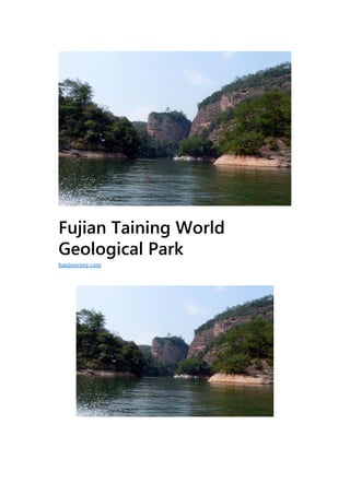
- 2. G eographic location:Taining County, Sanming City, Fujian Province Level:AAAAA Famous scenery:Jinhu, Taining Ancient City Climate type:Subtropical monsoon mountain climate Fujian Taining World Geological Park is located in Taining County, Sanming City, northwest of Fujian Province, with an area of 492.5 square kilometers, of which Danxia landform covers an area of 252.7 square kilometers. It consists of four parks, namely Shishi, Dajinhu, Baxianya and Jinyushan, and the tourist area of Taining Ancient City. The park is dominated by the typical youth Danxia landform, and has many geological relics such as volcanic rocks, granites and structural landforms. Comprehensive geopark. It has been rated as a national key scenic spot, a national 5A tourist zone, a national forest park, a national geological park, and a national key cultural relics protection unit. On February 11, 2005, UNESCO approved the Taining Geopark as the second batch of World Geoparks. Geographical environment Location horizon Fujian Taining World Geological Park is located in Taining County, northwest of Fujian Province, with an area of 492.5 square kilometers, of which Danxia landform covers an area of 252.7 square kilometers. The geographical coordinates are 116°45’00” to 117°18’11” east longitude, and 26°37’26” to 27°05’35” north latitude.
- 3. Topography The Taining Geological Park is dominated by Danxia landforms, with granite geomorphology, volcanic rock landforms and tectonic geomorphology, forming a large comprehensive geological park, including the stone network park, the Dajinhu Park and the Longwangyan and Daguding Scenic Areas of the Baxianya Park. For the Danxia landform, the Jinraoshan Park is a granite landform, and the Baiya Mountain Scenic Area of the Baxianya Park is a volcanic rock landform. The extreme development of the canyon is the most important feature of the Danxia landform in youth. The complex fault system formed by multi-phase tectonic activities, coupled with the flow of water, sculptures the geomorphological landscape of the geological park. The valley group consisting of more than 80 line valleys (first-line days), more than 150 lanes, and more than 240 canyons is characterized by its deep canyons, towering cliffs, numerous caves and ecological nature.
- 4. Climate characteristics The Taining World Geological Park is located on the southeastern side of the middle section of the Wuyi Mountains. It is a mid-subtropical monsoon-type mountainous climate. Summer is not hot, winter is not cold. The four seasons are mild and humid, with sufficient sunshine and abundant rainfall. The annual average temperature is 17 °C, the extreme maximum temperature is 38.9 °C, the lowest temperature is -10.6 °C, and the frost-free period is about 300 days. The rainfall in the area is abundant, with an average annual rainfall of 1788 mm and a relative temperature of 84%; the average sunshine hours is 1738.7 hours. Rich in light and heat, long frost-free period, mild climate and good ecological environment. Geological origin Fujian Taining World Geopark has experienced a long and complicated history of geological evolution. Since the Late Triassic,
- 5. the park has been under the influence of the interaction between the Pacific plate and the Eurasia plate. From the Late Jurassic to the Early Cretaceous, large-scale volcanic eruptions and magma intrusions took place in the park. Since the late Cretaceous, the park has formed a fault basin under the control of the Chong’an-Shicheng northeast fault zone and the Taining-Longyan north-south fault zone, and deposited a red rock stratum dominated by glutenite. After the Late Cretaceous, the crust was fully uplifted, and the re-active faults cut the rock layers, causing them to produce fissures and differences in elevation, geological structure, water erosion, collapse and weathering, which made the mountain peaks rise in the park and the cliffs were steep. Resource situation Water resources The water system in the Taining Geological Park is developed and belongs to the upper tributary of the Minjiang River. The main water system is Jinxi and its three tributaries of Tunxi, Shanxi and Paxi, which are collected in Taining. The combination of meandering middle-aged rivers and steep young rivers in the gorge is a basic feature of the rivers in the area. The park features deep-cut canyons.
- 6. Natural resources There are 102 species and more than 360 species of wild plants and rare trees in Taining World Geopark. Among them, there are more than ten kinds of species protected by the state, such as metasequoia, yew, longleaf, black sorghum and black tea. There are dozens of black tea trees, and there are nearly 25,000 acres of green forest. Scenic spots Maoer Mountain Maoershan National Forest Park is located in Taining County, Fujian Province, near the Jinhu Shili Pinghu Scenic Area. It is a bright pearl
- 7. on the Dajin Lake tourist line. The park covers an area of 2,560 hectares. The main scenic spot is the Golden Cat Mountain Scenic Area, Heming Mountain Scenic Area and Huangjia Lake. Scenic area, Pinghu scenic area. The Maoershan National Forest Park is rich in tourism resources, with rich forests and abundant species. The Fengyan Waterfall and various cultural landscapes are of various types. The visibility is very high: one is the green forest and the lush vegetation. The park has abundant forest vegetation, and the forest coverage rate in the scenic area is 90%. The second is the steep peak rock and the strange cave gorge. The landform of Maoershan Forest Park is a typical Danxia landform, which is a very precious landscape; the third is Bixi’s Pinghu, a beautiful waterfall. The park is surrounded by Pinghu Lake. There are spring waterfalls in the mountains and mountains, and valleys in the valleys. The fourth is a long history and magical legends. The fifth is a pleasant climate and a beautiful environment. The park is densely forested and has a high concentration of negative oxygen ions. It is known as the “natural oxygen bar” of Jinhu Lake. Zhuangyuanyan Zhuangyuanyan Scenic Area is located in Changxing Village, the northern suburb of Taining County, on the side of Shangqing River, 11.7 km from the urban area. The scenic area is 16 square kilometers.
- 8. Because of the Song Dynasty (1196), Zou Yinglong (1173-1245) studied here in the early years. And got its name. The Zhuangyuanyan scenic spot runs about 5 kilometers and is divided into five tourist areas. The tourist trails are all paved with stone steps. There are more than 80 large and small scenic spots such as Qianlong Gorge, Xuguling, Motianling, Wuhu Shangshan, Kongshan Liuxiang, Zhuangyuanyan, Sunjing Cliff and Jinxiu Valley. Jiulong Lake Jiulongtan Scenic Area is located in Shangqing Township, 15 kilometers upstream of Jinhu Lake, adjacent to Shangqing River and Zhuangyuanyan. The development of the scenic spot is positioned as “mountain and people, ecological paradise”, with a total planned area of 167.2 hectares. It is divided into five functional districts: religious culture, canyon exploration, water recreation, mountain people and reception services. Formerly known as Huanglonggang, Jiulongtan Scenic Spot was named Jiulongtan because there were nine mountain waters like dragons. The main scenic spot is Danxia Lake, which is composed of Danxia landform. The face of the lake is about 5 kilometers long, the widest point is about 100 meters, the narrowest part is less than 1
- 9. meter, and the pond depth is up to 18 meters. It is the fine product of Danxia on the water. The main attractions include Yinglong Gorge, Orangutan, Wangtan, Yulong, Yulong, Feilong, and Baotou. Among them, Yinglongxia has a total length of about 1200M, which is the longest waterfront. Taining Ancient City The ancient city of Taining is located in the city gate of Taining County in the south of Wuyi Mountain, with an area of 226.5 square kilometers. It has well-preserved Ming Dynasty residential architecture authenticity, the national key cultural relics protection unit – Shangshudi architectural complex, and buildings from various periods in the early Ming Dynasty to the late Qing Dynasty. The ancient city of Taining has a long history and is known as “Guihua Town”. It has a history of 1340 years and has the reputation of “Han Tang Ancient Town and Two Songs Famous City”. The ancient city of Taining was also the Central Soviet Area during the second Chinese revolutionary war. The national key cultural relics protection units Shangshudi and Shidetang are located in the city. The “Zhu De, Zhou Enlai’s old residence” and a large number of precious cultural relics are well preserved. The newly-planned new Huizhou-style war-angled imitation Song ancient city architecture is unique.
- 10. Zhaixia Grand Canyon The Zhaxia Grand Canyon Scenic Area is the key scenic spot of the Dajinhu Park of Taining World Geological Park. It is the key scientific research area for the evaluation of Taining “Shenshi” experts. Located in the intersection of Shancheng Town and Datian Township, it is 16 kilometers away from the county seat. The scenic area is about 2 square kilometers. It is named after a scenic spot like a dragon. The scenic spot is located in the geological fault zone of Shaowu, Fujian to Heyuan, Guangdong. It is a landscape of the Danxia landforms formed and developed in the background of the rift basin about 65 million years ago. The canyon is deep and long, and the valley is deep. Plants are dense. The main geological landscapes include Danxia Cave, Lane Valley, Line Valley, Chibi, Stone Wall, Lonely Peak, Stone Column, Collapse and Stacking, Barrier Lake, Piercing, Plate-shaped Interlaced Layer, Boulder, and Stone Bell Milk. The main attractions include Tianyan, Sanxianyan, Qitianxia, Yitianjian, Buzuyan, Jingui Climbing, Tianzhuyan, Cuizhu Lake, Yunyaling, Jinlong Line Valley Group, Jinguisi Waterfall, Line Waterfall, Huaxia The first vine, the thousand-year-old cedar king, the thousand vine wall and so on.
- 11. Shangqingxi Shangqingxi Scenic Area is located in the northeast of Taining, the upper reaches of Jinhu, about 22 kilometers from the county to Shangqing River. It is named after Taoism. The “upper Qing” is one of Taoism “three clearings”, namely Taiqing, Shangqing and Yuqing. It was later widely used to refer to “fairyland”. Shangqing Creek originated from Chuanli Village in Shangqing Township, Taining. It has a total length of more than 50 kilometers. It passes through the hinterland of Shangqing, passes through Changxing Village of Shancheng Town, and flows into Zhukouxi on Yuyaiping. Among them, the bamboo rafting section has been developed from Chongji to Changxing, with a length of 15 kilometers. The whole journey is about two hours. The journey is divided into ten miles, ninety-nine, eighty-eight, seventy-seven, sixty-six. The peaks, the fifty-five rocks, the forty-four scenes, and the thirty-three miles, the main attractions are “Squid Jumping Dragon Gate”, “Golden Bell Changming”, “Five Old Seeing Fairy”, “Sunshine Triple Stack”, “Peacock Opening Screen”, “Qiying Cliff”, “Liaoxia Wall” and “Hao City Tower”.
- 12. Jinhu Scenic Area Jinhu is a national key scenic spot. It is dominated by water and characterized by Danxia landform. It is a rare scenic spot that combines the Danxia landform with the vast lake water in China. In 1980, the state built a Chitan hydropower station with an installed capacity of 100,000 kilowatts in the reed beach on the upper reaches of Jinxi. Due to the construction of the power station dam, an artificial lake with long north and south and narrow east and west was formed in Taining County. The river is named Jinhu. The surface of Jinhu Lake is circular, like a new moon. The scenic area is 136 square kilometers, of which the water area is 38 square kilometers and the water storage is more than 700 million cubic meters. From Taining County to the power station dam, the total length is 62 kilometers, so it is called “Bali Golden Lake”. The golden lake is dark and blue, and the islands and lakes are connected. The cliffs of Danya can be seen everywhere, the ancient temples are dangerous, and the fishing boats are farmhouses.And ancient wood mountain flowers. There are Chibi Danya in the scenic spot, the first line of the water, the Maoer Mountain, the Baishuiyu Waterfall, the Shiliping Lake, the 醴(lǐ) Spring Rock, the Hutouyan, the Ganluyan and the Ganlu Temple, the Wuhu Lake, the Lovers Peak, the Glen Maizu, the Xiongzhu There are more than 180 places of interest such as peaks, suspension bridges and Shangshu tombs.
- 13. Chibi Danya Chibi Danya, commonly known as the Great Chibi. The Chishi Cliff is about 500 meters wide and about 100 meters high. The wall is not covered with grass, and the reflection is red through the lake. Therefore, it is called “Red Cliff”. A line of water One day on the water, it is one of the representative attractions of the Golden Lake Scenic Area. The rock is dangerous and the palms are double peaks. The lake rises and immerses the mountainside to form a deep green narrow waterway. The five characters on the left side of the stone wall, “The Water on the Line,” was inscribed by Liu Yi, the former director of the National Tourism Administration. This waterway is only 2 meters wide, more than 300 meters long, and the cliff is about 100 meters high.
- 14. Glen Maizu The valley is known as the “two-line sky”, the old name is twenty- four creeks, which means the bend of the twenty-four bends. This waterway is about 2 kilometers long and has cliffs on both sides. The boat turns left and turns right in the secluded canyon, giving people the feeling of turning around and confusing, so ya is called the valley. Shili Pinghu The most open water surface of Jinhu Lake – Shili Pinghu. It is 8 kilometers long from north to south, 3 kilometers wide from east to west, and more than 60 meters deep. The surrounding mountains are surrounded by mountains and the islands are dotted. The two streams of Jianning Tunxi and Taining Shanxi originally merged here to form Jinhu. On the right side of Shiliping Lake, there is a huge stone on the top of the mountain like a tiger head. It is called Hutouyan. There is a township named Meikou under the mountain. Therefore, this
- 15. mountain is also known as Meiyan. There is a military fortress built on the mountain in the Song Dynasty, named Hutou Village. Xiongzhufeng Located on the left side of Shiliping Lake, Xiongzhufeng is an isolated towering rock shaped like a genital. The Chinese nation has a custom of reproductive worship since ancient times, and this ancient culture is also circulated in the Jinhu area. Therefore named Xiongzhufeng.
- 16. Suspension bridge Suspension bridge, the bridge deck is 6 meters wide and 284 meters in span. It can pass 10 tons of cars. The inscription on the bridge head has five characters of “Jinhu Suspension Bridge”. Development and construction In January 1994, Taining was approved as a national key scenic spot. In 2001, Taining was rated as a national AAAA-level tourist area and a national geological park. On February 11, 2005, UNESCO approved the Taining Geopark as the second batch of World Geoparks. On January 30, 2009, Fujian Taining officially became one of the nominated sites for China’s “World Natural Heritage” due to its unique Danxia Geological Relics.
- 17. Travel Information Aviation From Beijing, Shanghai, Hangzhou, Guangzhou, Hong Kong and other places directly to Fuzhou, Xiamen, Wuyishan, and then take the car to Taining. Train From Beijing, Shanghai, Hangzhou, Guangzhou, Nanjing, Hefei, Nanchang, Fuzhou, Xiamen and other places directly to Shaowu, Shunchang, Nanping, Sanming and other places, and then take the car to Taining. Car Taining is 76 kilometers from Shaowu, 146 kilometers from Wuyi Mountain, 62 kilometers from Le Yuhua Cave, 184 kilometers from Nanping, 176 kilometers to Sanming, and 85 kilometers from Lichuan in Jiangxi. Passengers from Taining to Fuzhou, Putian, Shishi, Xiamen, Dongguan and Guangzhou were also opened. Fare information Attractions name Jinhu 165/person (including ticket, tour guide fee) Shangqingxi 95 yuan / person (including drifting fees, tour guide fees) Zhaixia Grand Canyon 55 yuan / person Taining Ancient City 25 yuan / person Jiulongtan 55 yuan / person (including drifting fees, tour guide fees)
- 18. Zhuangyuanyan 40 yuan / person Maoer Mountain 40 yuan / person Diboyuan 6 yuan / person (including tour guide fees, such as the choice of 4D theater plus 30 yuan / person) Red Rock Ditch Free Li Jiayan Free