Slender west lake
•
0 likes•34 views

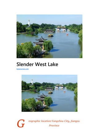
Slender West Lake is a nationally protected scenic area located in Yangzhou City, Jiangsu Province, China. It covers an area of 33.66 square kilometers and features scenic spots like Xiaojinshan, Wan Garden, and Xichuntai. The lake originated as the Baoyang River and got its current name "Slender West Lake" during the Qing Dynasty when Emperors Kangxi and Qianlong visited and appreciated its scenery. Over subsequent dynasties, the area developed many private gardens along its shores. It is now a major tourist attraction that has undergone restoration to preserve its classical landscape features while adding modern amenities.

Recommended
More Related Content
What's hot
What's hot (15)
Similar to Slender west lake
Similar to Slender west lake (20)
More from Journey Han
More from Journey Han (20)
Recently uploaded
Recently uploaded (16)
Slender west lake
- 1. G Slender West Lake eographic location:Yangzhou City, Jiangsu Province hanjourney.com
- 2. Level:AAAAA Famous scenery:Xiaojinshan, Wan Garden, Xichuntai Climate type:Subtropical monsoon climate Slender West Lake is located at No. 28, Dahongqiao Road, Hanjiang District, Yangzhou City, Jiangsu Province. It is a national key scenic spot, a national AAAAA-level tourist scenic spot, and a national civilized scenic tourist area demonstration site. Slender West Lake is located in the northern suburb of Yangzhou City. Because the lake is long and thin, it is called “Slim West Lake”. According to the data at the end of 2012, the scenic area of the scenic area is about 33.66 square kilometers. In 1988, it was listed by the State Council as a “national key scenic spot with important historical and cultural heritage and Yangzhou garden features”. In 2010, it was awarded the national AAAAA-level tourist scenic spot and became the first national 5A-level tourist scenic spot in Yangzhou. Historical evolution Ancient records In the early Qing Dynasty, Wu Song, “Yangzhou Advocating Words” (Fang Zhi) recorded: “The north of the city is one of the two famous lakes. The name of the two lakes is the name of the lake.” In the late Ming and early Qing dynasty scholar Gu Zuyu’s famous geographical work “Reading the History of the Party”, Volume 23 Jiangdu County Guanhe entry contains: “Baoyang River in the west of the Fuli, Sanli, the north of the city. The old Chaihe, East Daguan River, west of the city and the river into the city … and then on the
- 3. east bank of the river near the edge of the city, set up enemy stations, in order to prepare for enemy enemies, because of the name of the defending.” Origin of the name Slender West Lake is actually a wide river outside Yangzhou City, formerly known as Baoyang Lake. The name of “Slim West Lake” was not widely circulated until the Qing Emperor Qianlong. In the Qing Dynasty, Emperor Kangxi and Emperor Qianlong both visited the South for six times, and they appreciated the scenery here. The “Yangzhou Paintings” records that “the 22nd year of Qianlong… the two sides of the strait are built famous gardens”. At this time, the “slim west lake” has become a famous lake in the series of landscapes from a river. In addition, during the Qianlong period, Qiantang (now Hangzhou) poet Wang Yufu’s poem “咏保河”: “Changyang continues to pick up the wreckage, and Yanzi Hongqiao draws a picture. It is also a pot of gold, so it should be called a thin West Lake.” Make “Slim West Lake” famous in the world.
- 4. Historical changes Ming Dynasty At the beginning of the Ming Dynasty, the canal was renovated and became the artery of north-south traffic. Yangzhou once again became the economic recovery of the Lianghuai salt transport distribution center, and the gardens, especially the private gardens, were in a state of revival. During this period, a bridge appeared on the Slender West Lake – Hongqiao (now known as Dahong Bridge). The appearance of the Red Bridge laid the foundation for the rapid development of the slim West Lake Garden. Objectively speaking, this period is a relatively stagnant period in the history of the development of the Slender West Lake garden, but in the late Ming Dynasty, people began to pay attention to the Slender West Lake.
- 5. Qing Dynasty At the beginning of the Qing Dynasty, this was the early stage of the overall development of the Slender West Lake Garden. At this stage, conscious garden landscaping began near Slender West Lake. However, due to the small scale and relatively scattered scope, the slim West Lake garden is mainly a natural landscape, and does not form a good overall landscape effect. The large-scale construction of the Slender West Lake Garden was in the Qianlong period. In the middle of the Qing Dynasty, the Slender West Lake Garden reached its peak during her entire ancient evolution. The landscape of many slim West Lake gardens is the product of this stage. The Slender West Lake itself also One of the most representative areas of Yangzhou gardens. After the 20th year of Qing Jiaqing (1815), the salt industry in Yangzhou declined, and the gardens on the lake gradually became sluggish. Since then, it has experienced the wars of the Taiping Heavenly Kingdom, and it has been ruined. During the reign of Guangxu, a small part of Wuting Bridge and Xiaojinshan were restored.
- 6. Modern With the loss of traffic, Yangzhou eventually lost its superior transportation status, economic depression, and the destruction of war. The Slender West Lake Garden was once hit hard at this stage. However, due to the status and role of Slender West Lake in the production and life of Yangzhou City, the construction of the slim West Lake Garden is still developing forward. Although it has been repeatedly damaged, it is constantly renovating and reconstructing the original landscape, and new Increase the landscape. Modern After the founding of the People’s Republic of China, the Slender West Lake Garden began to be fully restored. While retaining the original classical landscape features while considering the needs of modern people for landscape functions, some functional buildings and related facilities were appropriately added. In the 1980s, the 24th Bridge, Xichuntai, and Guanshidongtian were restored. In 2007, the four bridges were restored, such as the rain and the stone wall. The water area is continuously dredging, and the area is gradually expanding. The garden covers an area wider than before. The landscape is more
- 7. layered and practical. By the end of 2012, the area of the scenic area has reached 33.66 square kilometers. Geographical environment Position Yangzhou Slender West Lake Scenic Area is located in the northern suburb of Yangzhou City, Jiangsu Province. The coordinates are at 32°24′13.76′′ north longitude and 119°25′16.59′′ east longitude. Climate The Yangzhou Slender West Lake Scenic Area belongs to the transition zone from subtropical monsoon humid climate to
- 8. temperate monsoon climate. The main features of the climate are distinct four seasons, abundant sunshine and abundant rainfall. The prevailing wind direction changes significantly with the seasons. In the winter, the northerly wind is dry and cold, and the northeast wind and the northwest wind are mostly; in summer, the southeast to the east wind are hot and humid from the ocean, and the southeast wind is mostly; the southeast wind is more in spring; the northeast wind is more in autumn. Winter is too long, more than 4 months; summer is second, about 3 months; spring and autumn are shorter, each more than 2 months. Construction Planning Forest ecosystem construction The construction of forest ecosystem in the Slender West Lake Scenic Area of Yangzhou is based on the species composition, structural characteristics and succession laws of zonal plant communities. The tree species are based on the local tree species resources, and the ecological principle of “suitable for the trees” is always followed in plant allocation. Make full use of the native tree species with excellent landscape, and combine the historical and cultural traditions of the scenic spot with the functional requirements of the garden green space, and configure the plants according to local
- 9. conditions to form a stable and complex mixed community. The common tree species such as mulberry, scorpion, scorpion, camphor, Fengyang, Nanshu and Pushu are widely distributed in the Nanshan Mountain in the scenic area of Slender West Lake. Natural succession and reproduction into forests form natural ecological forests. Since 2003, Yangzhou Slender West Lake Scenic Area has introduced some ground cover plants with strong resistance and high ornamental value according to local characteristics, and has been enriched and enriched with plant varieties, and according to their habits and growth characteristics, The two-year-old grass flower is reasonably configured, forming a colorful flower bed, flower border, flower fence and other landscapes. In the years of green space construction, Yangzhou Slender West Lake Scenic Area follows the ecological principles, ecological garden principles and plant community principles, and builds green plant plants into cultural plant communities or ornamental plant communities. The Yelin and Houshan in the scenic area have formed a relatively successful artificial plant community with four levels of high, medium, low and ground. All the plants in the community are flourishing and grow well, forming a benign The ecological environment of the cycle. As of 2005, there are 319 species of 163 genera and 78 families of green trees in the Slender West Lake Scenic Area. There are more than 100 species of herbaceous ornamental plants used as flower beds and ground cover plants, and more than 20 species of vines for vertical greening. Aquatic plants There are more than 10 kinds.
- 10. Construction layout The scenic spots of Yangzhou Slender West Lake Scenic Area include Yuanyuan Garden and Hidden Type. For the Garden Park, the introverted layout is generally adopted. For example, Baita Qingyun and Jingxiang Book House generally require a certain width of terrain conditions. It can be operated and the slim terrain of the West Lake area is slender, so the building is placed directly at the water’s edge, and the main facade of the building with the expansion of the discrete outward layout is facing the water surface, which is obviously different from the pattern of the north facing south of the Chinese national residence. Highlights the characteristics of the garden on the lake. In order to enhance the strength of the virtual and real contrast, try to make the building close to the water’s edge, so as to produce clear and complete reflections, such as the clearing room and the Xiangxue Pavilion. The platform rises from the water, and the building seems to float above the water. Stretch. The scenic spots of Yangzhou Slender West Lake Scenic Area have always formed a large scale in the meander, such as Xiaojinshan, Xichuntai and Wangchunlou. Most of the buildings along the river bank are mainly long strips, and the architectural combinations are also arranged in a vertical direction, which is consistent with the terrain of the entire scenic spot and the direction of the river bank.
- 11. Landscape attractions Spa Yangzhou Slender West Lake Hot Spring Resort is on the bank of Slender West Lake, facing the Wan Garden. The resort covers an area of 130,000 square meters and has 68 hot spring pools with different shapes and functions. It is divided into public areas and private areas. The public areas are divided into lake streams, rockery waterfalls, small bridges, pavilions, bamboo forest trails, etc. Each theme space has its own characteristics. Dahongqiao Dahong Bridge is one of the twenty-four scenic spots in Yangzhou. It was built in the Ming Chong-Yuan period and spans the lake. The original bridge was a wooden red bar, hence the name Hongqiao. In the first year of Qianlong in the Qing Dynasty, it was converted into a stone bridge. In the early years of the Qing Dynasty, the patrols of the Yushi Jiqing, Pfu, and Gaoheng were successively rebuilt, and bridges were built on the bridge. The “red” was changed to “rain”, meaning the bridge was like a rainbow. It has been converted into a 3-hole
- 12. low-slope bluestone bridge of 7.6 meters wide. Hongqiao was once famous in history. When Emperor Qianlong visited Yangzhou, he also made poems to appreciate the scenery of Hongqiao. Jin Jing Ge Jinjingge is a water pavilion that is reconstructed by a bridge and pavilion reconstructed by Jinjingge as described in Li Dou’s “Yangzhou Paintings”. The three open space is a large building with a shape like a character, spanning a small river (Caihe). On the upper and lower sides, the two sides straddle the two sides, with empty space in the middle, and can pass through the boat. When crossing the river, pedestrians must cross the second floor of the stairs, such as crossing the bridge, and then descend the stairs from the other side to the opposite bank. Jinjing Pavilion is now a mixed cement and wood building.
- 13. Wuting Bridge Built in the 22nd year of Qing Emperor Qianlong, Wuting Bridge has a history of more than two hundred years. There are five wind pavilions on the bridge with southern features. There is a treasure roof on the pavilion, a ceiling in the pavilion, and a wind chime outside the pavilion. The pier of Wuting Bridge is made up of 12 large blocks of bluestone, forming a thick and powerful “work” type bridge foundation. The bridge body of Wuting Bridge is composed of a coil hole of different sizes and shapes. If you take the boat under the bridge, you can count the five pavilions and have a total of 15 bridge holes. The holes are connected and the holes are connected. Diaoyutai In China, there are many scenic spots named after “Diaoyutai”, but Yangzhou’s Diaoyutai is the smallest and most characteristic of many fishing platforms. Standing on the angle of the Diaoyutai at 60
- 14. degrees, you can see the Wuting Bridge lying in the round hole in the north, while the elliptical hole in the south can see the white tower. Xiaojinshan Xiaojinshan is the largest island in the Slender West Lake and the most densely populated place on the lake. The wind pavilion, the blowing table, the piano room, the wooden book house, the chess room, and the moon view are all concentrated here. There is a history of the name of “Xiaojinshan”: it is said that there are two monks from Yangzhou and Zhenjiang who chatted, and Zhenjiang monk said: “Qingshan also hates the state customs, and how many peaks are not over the river.” Yangzhou certainly does not agree with this. Said, so the two bet on playing chess. As a result, the monk of Yangzhou was high in chess. The scene was named “Xiaojinshan”, and such a couplet was hung in the court: “The finger is empty, the jade bureau can be left with it; if the fist is not big, Jinshan will also Jiang Lai. “With only one “small” word, the “Jinshan” of Zhenjiang was extradited.
- 15. Wangchun Building Yangzhou Slender West Lake Wangchunlou is opposite to the lake is the exquisite flower. It is a style building of Jiangnan gardens, and its scale is subordinate to Xichuntai. The north and south of the lower part of the Wangchun Building are respectively water parks and mountain courts, bringing landscapes into the interior. Unloading the doors and windows upstairs becomes a terrace. General Xiao Li is Li Zhaodao, a famous ancient painter who jointly created the Jinbi Landscape Painting School of the Tang Dynasty in China. Known as “flowers for painting, month is the source of poetry.”
- 16. Xichuntai Xichuntai is the main building of the 24th Bridge Scenic Area, which is opposite to Xiaojin Mountain. It is also one of the “Twenty-four Scenes” of Yangzhou. The word “Xi Chun” comes from Laozi’s ‘Everyone Hee Hee, such as Deng Chuntai.’ It means the bustling scene of the people in front of Xichuntai who came to the shoulders. It is said that Yangzhou salt merchants once celebrated the birthday of Emperor Qianlong here, so this One scene is also known as “Spring Terrace Birthday”. White tower The white tower is 27.5 meters high. Below is the waist-bearing minaret, eight sides and four corners, three sides on each side. According to legend, in 1784, Emperor Qianlong took a boat trip to Yangzhou Slender West Lake for the sixth time. Seeing the scenery of Wuting Bridge from the water, I can’t help but say: “It’s a pity that there is a white tower missing. Otherwise, it seems that the Qiongdao Chunyin in the North Sea is like a great one.” The speaker was unwilling to listen. The Yangzhou salt merchants, who were rich in money, immediately spent 100,000 yuan and the eunuchs bought the pattern of the Beihai Baita. They piled up with white salt in the night
- 17. to form a white tower. This is the story of “Building a Tower One Night” that has been passed down in Yangzhou. Moon view Yangzhou is “the moon city of China”. The moonlight beauty of Yangzhou and the place to enjoy the moon are also many. The “moon view” is one of them. “Moon View” sits west to the east, and faces the open lake. Whenever the moon rises, it stands on the side of the column. The two moons in the sky meet each other, and you can appreciate the wonderful mood of “the moon is full of water, the sky is a day.” .
- 18. Xu Yuan Xu Yuan is located in the north of Chunliu Lake, the longwall of Chunliu Lake. The original site was the Hanyuan Taohuawu Han Garden in the early Qing Dynasty. In the four years of the Republic of China (1915), in order to commemorate the commander of the martyr Xu Baoshan during the Revolution of 1911, Xu Baoshan Temple was built, named Xu Yuan. Xu Yuan covers an area of 0.6 hectares and is small and exquisite. The Nanmu cover in the pavilion is the best in Yangzhou’s existing hood. There is a pavilion, a pavilion and a pavilion in Xuyuan. There is a water outside, and there are ponds, flowers and bamboo stones, just right, which fully reflects the exquisite elegance of Jiangnan gardens. Every autumn, Yangzhou’s annual chrysanthemum exhibition is held in Xuyuan. Twenty-four bridge The “Twenty-four Bridge” comes from the poem of Du Mu, a famous poet of the Tang Dynasty. “The green mountains are faintly slumbered, and the grass in the south of the Yangtze River is not
- 19. withered; the twenty-four bridges are bright and moonlit, where the jade people teach to brag.” The twenty-four bridges in the minds of Yangzhou people are composed of the Luofan Plank Road, the single-hole arch bridge, the Jiuqu Bridge and the Blowing Xiaoting. The jade-shaped arch bridge in the middle is 24 meters long and 2.4 meters wide. There are 24 on the upper and lower sides of the bridge. Steps, surrounded by 24 white jade railings and 24 fences. Regarding which bridge the twenty- four bridge refers to, there have been many opinions. Million garden The west and south sides of Wan Garden are adjacent to Slender West Lake, with a small canal in the north and Pingshantang Road in the east, with a total area of about 500 mu. Designed by Hangzhou Garden Design Institute, it mainly relies on the historical and cultural background of Slender West Lake, and takes it as the theme of flower culture. With the classical historical garden as the clue, it focuses on restoring and perfecting the “Stone Wall Flowing” and “Jingxiang Book House”. The scenic spots such as “White Tower Qingyun” have ten functions of flowering, exposing, viewing, experience, intellectual interest, leisure, education, ecology, entertainment and aesthetics. Since April 18, 2007, Wan Garden has officially merged into the Slender West Lake Scenic Area. Visitors can enter the Wan Garden
- 20. directly or enter the Wan Garden through the Wuting Bridge or the Slender West Lake North Gate. Wan Garden does not charge separately. Citizens and tourists can enter Wan Garden for sightseeing with tickets such as Slender West Lake tickets and annual tickets. Every year from April 8th to May 8th, China Yangzhou Wanhua will be held in Slender West Lake Garden. Four bridges A building in the east is called “four bridges of rain.” Whenever the “mountain is empty and rainy and strange”, the view here is “four bridges flying across the smoke.” Standing on this floor, you can see four Chunbo Bridges, Dahong Bridge, Changchun Bridge and Lotus Bridge with different colors and shapes. In the misty and rainy, the four bridges are far and near, thick and light, high and low. At that time, the Emperor Qianlong was very fond of the scenery here. He repeatedly wrote poems and gave a gift to the “Fun Garden”.
- 21. Cultural development Cultural relic protection Within the planning area of Yangzhou Slender West Lake Scenic Area, there are 20 cultural relics protection units. among them: 1 national key cultural relics protection unit: Yangzhou City Site (隋——Song); 6 provincial-level cultural protection units: Shi Kefa, Tomb (including Gumeihualing), Tianning Temple, Chongning Temple, Lianhua Bridge, Daming Temple and Jianzhen Memorial Hall, Tianshan Han Tomb; There are 12 municipal-level cultural protection units: Yechunyuan, Dahongqiao, Xuyuan, Xiaojinshan, Baita, Qisiqiao, Guanyinshan, Gucheng Temple, Tiefo Temple, Xiongchengji Tomb, Shitao Tomb, Lianxi Tomb, Martyrs Cemetery.
- 22. Performing arts culture In the Wan Garden of Yangzhou Slender West Lake Scenic Area, a live performance of Jiangnan Garden is performed every night. Relying on Yangzhou’s profound historical culture and beautiful natural scenery, it reproduces the garden style of Jiangnan and shows Yangzhou’s beautiful natural landscape and humanistic charm. The performance takes the slim West Lake water and garden landscape. The Yangzhou Slender West Lake Scenic Area’s performance of “Spring River Flowers, Moonlight Nights and Beautiful Yangzhou” reflects the Yangzhou style and historical stories of the six eras of the Tang, Tang, Song, Ming, Qing and Jin Dynasties. From the spectacular scene of the Emperor Sui Di Grand Canal to the poetic mood of “Fireworks in March under Yangzhou”, from Du Mei Niang’s beautiful love to Shi Kefa’s heroic soul, from singing to the blessing of the whole fireworks, Yangzhou thin The history of the West Lake is vividly presented to the viewers. Scenic honor In 1988, the Yangzhou Slender West Lake Scenic Area was listed by the State Council as “a national key scenic spot with important
- 23. historical and cultural heritage and Yangzhou garden features”. In 1996, Yangzhou Slender West Lake Scenic Area was listed as a national key cultural relics protection unit. In 2009, the Yangzhou Slender West Lake Scenic Area was awarded the National Cultural Tourism Demonstration Zone by the Ministry of Culture and the National Tourism Administration. In 2009, Yangzhou Slender West Lake Scenic Area was awarded the National Grand Relics Park by the State Administration of Cultural Heritage. In 2010, Yangzhou Slender West Lake Scenic Area was rated as National AAAAA Scenic Spot by the National Tourism Administration, becoming the first national 5A-level tourist scenic spot in Yangzhou. In 2012, Yangzhou Slender West Lake Scenic Area won the honorary title of Advanced Collective of the National Tourism System. Travel Information Scenic spot tickets price: Low season fare: 120 yuan / person, peak season fare: 150 yuan / person Ticketing time: 6:30-17:30
- 24. Best time to travel From March to June each year, Yangzhou’s fireworks March trade and tourism festival is the most beautiful time of Slender West Lake. Scenic festival Every year from April 18th to May 18th, “Fireworks March Economic and Trade Tourism Festival” Every year from September 8th to October 8th, “Two Minutes of the Moon Cultural Festival” Special reminder for the scenic spot: In addition to visiting the Slender West Lake Park, a ticket to the Slender West Lake Scenic Area in Yangzhou can also be visited in the bonsai garden in the southeast direction of Slender West Lake. The two parks are separated by about 500 meters.