Yuntaishan world geopark
•
0 likes•64 views

Hanjourney.com | Famous tourist attractions in China

Recommended
More Related Content
Similar to Yuntaishan world geopark
Similar to Yuntaishan world geopark (20)
More from Journey Han
More from Journey Han (20)
Recently uploaded
Recently uploaded (20)
Yuntaishan world geopark
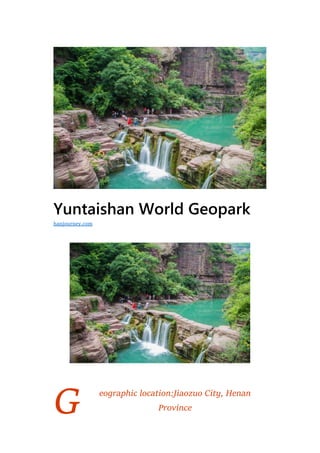
- 1. G Yuntaishan World Geopark eographic location:Jiaozuo City, Henan Province hanjourney.com
- 2. Level:AAAAA Climate type:Temperate continental monsoon climate Ticket price:120 yuan (peak season), 60 yuan (off season) Yuntaishan World Geopark is located in the south of Taihang Mountain, north of Jiaozuo City, Henan Province, with an area of about 556 square kilometers. It is dominated by rift structure, hydrodynamic action and geological landscape, supplemented by natural ecology and human landscape. A comprehensive geological park with scientific values and aesthetic values. The Yuntaishan Geological Park was established in 2002. It is mainly characterized by the structure of the single-sided mountain landform of the Yuntaishan Park, the cliff waterfall and the clear spring landform. The “Gantai Landform” landscape of the inter-group gorges, the peaks and valleys, the cliffs and the cliffs, is a special landscape formed mainly by tectonic action and natural erosion. It is a new type of landform. Type, both aesthetic and typical. At present, there are more than 170 kinds of natural landscapes, including more than 100 peaks and more than 10 steep cliffs. The valley retains a large number of geological relics, systematically unique strata, rocks and minerals, and typical geological features. The structure, the singular and diverse Dongfu, the unique ecology and the long history of humanistic tourism resources. Yuntaishan World Geopark is the world’s geological park, the national AAAAA-level tourist scenic spot, the northern boundary of China’s special vegetation and the highest latitude macaque reserve. Located in the mid-latitude area, it is a warm temperate continental monsoon climate with four distinct seasons, spring and dry winds, hot summer and rainy, high autumn and cool, and cold winter with less snow.
- 3. Historical evolution Yuntaishan began to investigate and prove in 1983. It was officially developed in 1985. In December 1987, it was identified as a provincial-level scenic spot by the Henan Provincial People’s Government, and the first batch of national AAAAA-level tourist attractions. In April 1989, the Yuntaishan Scenic Area Administration was established, which was established at the official level. In March 1997, it was upgraded to a deputy county-level institution. In October 2003, it was upgraded to a county-level institution with offices, propaganda, finance, planning, security, and Baijiayan management, Xiaozhaigou management office, Hongshixia management office, and onshore management office. And the peak management office and other four departments and five departments. In 2005, it invested heavily in building a digital monitoring center to provide visitors with a comfortable and convenient travel environment.
- 4. Geographical environment Location horizon Yuntaishan World Geopark is located in the south of Taihang Mountain, north of Jiaozuo City, Henan Province, with an area of about 556 square kilometers. It is a geological park with rift structure, hydrodynamic action and geological features. Climatic characteristics Yuntaishan World Geological Park is located in the mid-latitude area. It is a warm temperate continental monsoon climate with four distinct seasons, spring and dry winds, hot summers and rainy days, high autumn and cool weather, and cold winters and less snow.
- 5. Hydrology The river landscape mainly includes the Snake River, the Niuyue Lake, the Heshan Mountain, the river rejuvenation, the river terrace, the torrent travertine, the rock shovel, the pot hole, and the stone trough. The waterfalls vary in size and dozens of waterfalls are diverse. Among them, the Yuntaishan Tian Waterfall is the most spectacular, with a drop of 314 meters. Most of the lakes are artificial lakes, including Xiaoyao Lake, Xianshen Lake, Qingtianhe Reservoir, Weiyuan Lake, Qinglong Lake, Zifang Lake, etc. Among them, Zifang Lake is most famous for its rare peach blossom jellyfish.
- 6. Resource situation Water resources The park is divided into Yuntai Mountain, Shennong Mountain, Qinglong Gorge, Fenglin Gorge and Qingtianhe. Yuntaishan Suspension Spring Waterfall, Qinglong Gorge Deep Valley, Fenglinxia Stone Wall Shrink, Qingtian River Bishui Liantian, Shennongshan Longji Great Wall. Animal and plant resources The Yuntaishan World Geopark completely preserved the Middle Proterozoic and Paleozoic marine environments, especially the sedimentary relics of the surface sea environment. The special geotectonic location forms a unique hydrodynamic condition, which creates the unique geographical features of the park and becomes the northern boundary of China’s special vegetation and the highest latitude macaque reserve.
- 7. Mountain resources The Yuntaishan World Geopark consists of a series of geological relics with special scientific significance and aesthetic value that can represent the geological history and geological functions of the region. The “mountain landform” formed under the background of the rift is a typical relic of the neotectonic movement and a new member of the Chinese geomorphic family. A relatively complete and representative platform-type deposit has been developed on the North China paleocontinental nucleus that has been in a stable state for a long time.
- 8. Main Attractions Five major parks Yuntaishan Park Yuntaishan Park is located in the north of Xiuwu County, Jiaozuo City, with an area of about 55 square kilometers. The geological heritage in the park is rich and colorful. The 3 billion-year-old shoal of the sea has formed the Taiguyu, Yuanguyu, Paleozoic and Cenozoic strata; many tectonic movements, especially the strong uplift and water erosion of the neotectonic movements since 23 million years ago The depth of the action cuts down, creating the canyon group of Yuntaishan Shuangyao and the various dynamic waterfalls, springs, streams and lakes, which together constitute the “Pengtai Landform” landscape. Qinglongxia Park Qinglongxia Park is located in the northwest of Xiuwu County, covering an area of about 90 square kilometers. It is divided into two major scenic spots: Qinglong Gorge and Aiqu Cave. Qinglong Gorge is
- 9. a large canyon that is formed in the background of the East Asian Rift Valley and formed by deep rivers. It has a total length of 7.5 kilometers and a width of more than ten meters. The narrowest part is only a few meters, and the gorge is 600-700 meters deep. The waters of the Qinglong River are flowing along the valleys and flowing at the bottom of the valley. Due to the ups and downs of the terrain, waterfalls, rapids, Tunxi and Bitan are formed. The caves on the cliffs have their own characteristics. The two caves are pierced by ridges, the mysterious mysteries of Qinglong Cave, Sanguan The cave is more than 300 meters deep. The cave is filled with water for many years. The fossils in the strata are rich and varied, including hornbeams, trilobites and stromatolites. Qingtianhe Park Qingtianhe Park is located in the north of Bo’ai County, covering an area of 45.2 square kilometers. It is divided into three scenic spots: Qingtian River, Danhe Canyon and Yueshan Temple. It is a gorge-like landscape with a unique history and culture. For the connotation, the geological park park for tourists’ leisure vacation, sightseeing and science education. The Qingtian River is named after the Gaoxia Pinghu and the beautiful scenery. Daquan Lake is known as the “Northern Three Gorges” and “Guilin Mountains and Waters”. Yueshan Temple is the birthplace of China’s “Tai Chi”.
- 10. Fenglinxia Park Fenglinxia Park is located in the north of Jiaozuo City, covering an area of 50 square kilometers. It is divided into two major scenic spots, Weiyuan Lake and Jingyingxia. It is dominated by a canyon and a peak forest. Weiyuan Lake Gaoxia Pinghu, Jingyingxia Qifeng, Xianling and Deep Valley together constitute the unique landscape of the park.
- 11. Shennongshan Park Shennongshan Park is located in the northern part of Fuyang City, covering an area of 96 square kilometers. It is divided into three scenic spots: Zijinding, Xianshen River and Xiaoyao River. It is characterized by Qifeng, Yiling and Canyon, with a long history and culture as its connotation. A geological park park where visitors can enjoy the scenery and camping adventures. Top ten attractions Red Rock Gorge The Red Rock Gorge is the Bishui Dan Gorge formed by the strong uplift of the neotectonic movement and the deep cutting of the water erosion. Rich geological phenomena such as staggered bedding, layer wave marks and cracked structures in the sandstone layer.
- 12. Longji Great Wall Longji Great Wall is a towering dragon-ridged mountain between two canyons. It is 11.5 kilometers long, 100-200 meters high and only a few meters to ten meters wide. The entire mountain is composed of limestone. The near-level production of the bedding and the two sets of vertical joints jointly cut the limestone into blocks of different sizes, which is called geologically residual watershed. Whale Bay Whale Bay is a semi-circular turn in the Qingtianhe Park. It looks like a bird’s head because its inner side of the mountain beam looks like a whale’s head. The water level near the two meters is similar to the whale’s lips, hence the name Whale Bay. It is a unique geomorphic form formed by the long-term erosion and undercut of the river in the near-south-north-trending fracture zone and the near-east-west
- 13. secondary fault formed in the background of the East Asian Rift. It can be compared with the “Big Turn” of the Yarlung Zangbo River. Tan Waterfall Gorge Tanpu Gorge is the most characteristic water body music garden. The abundant surface water and groundwater in the north and the joint fissures of limestone and dolomite make the cliffs and valleys deep in the area, densely covered with waterfalls, springs, streams and lakes, which are rare in northern China.
- 14. Qinglongxia Located in the north of Jiaozuo City, Qinglong Gorge is an ecological tourist area dominated by landscapes. It has the reputation of “the first gorge of the Central Plains”. Fenglinxia In the fissure valley formed by the deep cleavage of the Fenglin Gorge along the tectonic extensional zone, the mountain is separated by a height of tens to hundreds of meters, a length of tens to several kilometers, and a width of several meters to a hundred meters. The cliff wall of the cliff. The inherent solubility of carbonates makes the top of the peak wall often appear as a peak cluster.
- 15. Ovary Lake Zifang Lake, named after the Han Dynasty Zhang Liang (zizifang) helped Liu Bang to retreat after the great cause. The ovary lake has one of the most primitive and lowest invertebrates in the world, the peach blossom jellyfish, known as the “water panda”. Quanpu Gorge The spring waterfall is high and the waterfall is high. There are many clear springs flowing out of the ditch wall and the valley bottom. It flows up the canyon and has the attractions of porous spring, whispering spring, secluded pool and dragon waterfall. The first waterfall in China, the Yuntai Tian Waterfall, with a drop of 314 meters, is located at the end of Quanpu Gorge. This gorge was formed during the Cambrian period of 5.4-490 million years ago. After 23 million years, it has experienced long-term water erosion, handling, and gravity collapse, causing the ancient plane of 800-1200 meters above sea level to be strongly cut down, forming a length of 3000. Meter, a 500-meter deep canyon. There are geological relics
- 16. such as glutinous limestone, pinnate cross-layering, and collapsed rock. Shennong Mountain Shennong Mountain belongs to the Taihang Mountains and is a typical natural landscape of the South Taihang. It is characterized by Qifeng, Yiling and Canyon. With a long history and culture as its connotation, it is a good place for tourists to enjoy the scenery and camping adventure. The main peak Zijinding is 1028 meters above sea level and is known as “Zhongtian Yuzhu”. The Shennong altar at the top of the mountain is known as the “first altar of the world” by its cultural experts for its high altitude and time. Responding to the “Yanhuang descendants’ ancestral altar” has become a holy place for the descendants of Yan and Huang to worship the human ancestors Yandi Shennong.
- 17. Qingtianhe Qingtianhe is known as the “Northern Three Gorges” and “Guilin Mountains and Waters”. Covering an area of 106 square kilometers, the scenic area consists of dam, Daquan Lake, Sanguquan, Xixia, Foerxia, Qijialing, Yueshan Temple, and other seven tourist areas, and 308 scenic spots. It is a collection of Nanbei landscape features. A rich cultural heritage, a comprehensive scenic area for leisure, sightseeing, vacation, and science education. Ancient artifacts Yuntai Temple At the peak of Yuntai Mountain. In the first year of Shufeng (666), Tang Gaozong chased Laozi as “the Emperor of Emperor Xuanyuan”. During the Tang Emperor Xuanzong, he ordered the construction of 36 Xuanyuan Temples dedicated to the Emperor Xuanyuan in the country. This temple is one of them. In the Tang Dynasty, the Xuanyuan Temple in Yuntaishan flourished and the Taoist priests were numerous. But after the Five Dynasties, the Xuanyuan Temple
- 18. was gradually decadent. At the beginning of the Ming Dynasty, because the Ming Taizu Zhu Yuanzhang especially praised the Emperor Zhenwu, he had been worshipping the temple for more than 30 years in the Wudang Mountain. The Taoist believers in the country also turned to believe in the Emperor Zhenwu. The Xiuwu believers built the enshrined on the abandoned site of the original Xuandi Temple. Yuntai Temple in Zhenwu. Yuntai Temple, also known as the Xuan Emperor Palace, is located at the top of Yuntai Mountain. In addition, since ancient times, there have been a large number of folk stories in which the Emperor Zhenwu practiced immortality. Therefore, it echoes with Nanding Wudang and is known as the “Northern Top”. Yuntai Temple is the most prosperous in the Ming and Qing Dynasties. The whole county believers must organize the pilgrimage to burn the incense on the third day of the third lunar month, and become an important “Northern Top” activity in the year. After the founding of New China, the Taoist priests were still vulgar and the temples were gradually abolished In the late 1990s, the reconstruction of Yuntai Temple began, and Wu Dao Taoist was invited to serve as the abbot. In 2007, the Yuntai Temple was re- planned and expanded.
- 19. Qingjing Palace The Qingjing Palace was built in 1750 (the 15th year of the Qing Emperor Qianlong) and is the only Qing Dynasty unbeamed building group preserved in China. It faces south and is built on the mountain. The center is Sanhuangge, the left is Wangmu Temple, and the right is Yuhuangge. They are double-story buildings. The most special place is to break the axis symmetry in architectural style. The architectural pattern of the Taoist temple of the Buddhist temple combines the caves of the east with the pavilions of the west, and the materials are all stone, which is a must for the ancient buildings of the Central Plains. Erxian Temple The Erxian Temple, the real name of Jingying Temple, is located on the east bank of the Shenshen River estuary. Here, the left hanging valley, the right Zijin, the former small pool, the back Muxi, the water ring emerald, the natural scenery is very beautiful. Founded in the Tang Dynasty, Song, Yuan Ming, and Qing continued to repair. Legend has it that Tang Liyuan and Li Shimin fled to the ground, and the second fairy walked out of the cave to solve the problem of grain and spot. Li’s father and son said that after the emperor, he would be
- 20. given to the Second Immortal to build a temple. The Erxian Temple has a depth of more than 1,500 meters and a width of nearly 100 meters. There are five gates in front. There are Tianwang, King Kong, Bell and Drum Tower, and five heavy cabinets. There are many Tongsheng monuments. Feilai Stone is located in the hall of Zixu Yuanjun. A stone is isolated and is about three feet high. It is split in the middle and has a dressing table. It can be twisted on the plate. The stone wall is engraved with Song Ren religious books and Wang Antuqi Yuxiang sacred inscriptions and many inscriptions in the Ming and Qing Dynasties. There is a dressing table with two centuries on the flying stone, which is also a scene of the myth of Li Erdou and Erxian. Visitors often locate the stone and sew, and determine the male and female children by stone. Development and construction Infrastructure The Yuntaishan World Geopark became a geological park in 2006. In March 2007, the Yuntaishan World Geopark also carried out a publicity campaign with the Grand Canyon National Park. In 2010,
- 21. the China Yuntaishan National Culture Festival strongly promoted the development of Jiaozuo. Jiaozuo City received a total of 9,845,900 tourists, with a ticket income of 268 million yuan and a comprehensive income of 7.378 billion yuan. The Yuntaishan World Geopark has become an important pillar industry. Management system The Yuntaishan World Geopark has perfected the management institutions by realizing the scientific, standardized and standardized needs of park management and management, and combining the actual conditions of the park. Each scenic area administration also has a comprehensive office, a finance office, a geological heritage protection section, a publicity section, an security section, a planning and construction section, a sanitation department, a tour guide department, and a marketing department. Realize the protection and standardization of geological relics in the park, institutionalize and procedurize tourism services, and develop the geological park business in an orderly manner.
- 22. Travel Information Yuntaishan World Geopark is convenient for transportation. The northern part of the park is bordered by Shanxi Province, the west is bordered by Jiyuan City of Henan Province, and the east is adjacent to Xinxiang City of Henan Province. Taking coke as a starting point, roads and railways lead to all directions. It is 100 kilometers south to the provincial capital Zhengzhou, 60 kilometers east to the (North) Jingguang (state) railway or Xinxiang station on the expressway, 700 kilometers to the capital Beijing, and 80 to 120 kilometers west to the Gongyi. Or Luoyang can directly set foot on the Lian (Yungang) Huo (Ergos) railway and highway with the Eurasian Continental Bridge; 400 kilometers to the north can directly reach Taiyuan City, the capital of Shanxi Province. Take a flight to Zhengzhou, Luoyang and other airports to change trains or cars to parks. After arriving in Jiaozuo City, you can take all kinds of buses and taxis to Yuntaishan Park, Shennongshan Park, Qinglongxia Park and Qingtianhe Park. Ticket price Ticket price of Yuntaishan Park, peak season: 120 yuan / person (peak season: March to November), off season: 60 yuan / person (off season: December to February). Transportation fee within the scenic spot: 60 yuan / person (children under 1.3 meters in height, free of charge for internal transportation). Opening hours: 06:30-19:00. Ticket price for Qinglongxia Park: 30 yuan. Ticket price for Qingtianhe Park: 50 yuan, opening hours: 07:00 –
- 23. 17:00. Ticket price of Shennongshan Park: 60 yuan for adults, 30 yuan for students and children, opening hours: 08:00 – 18:00.