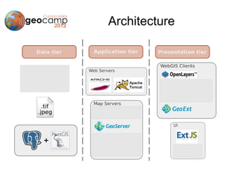
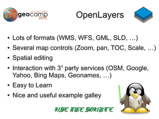
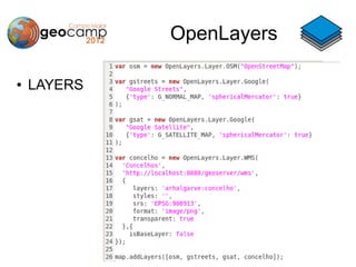
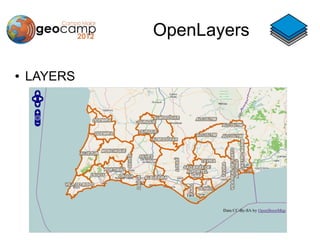
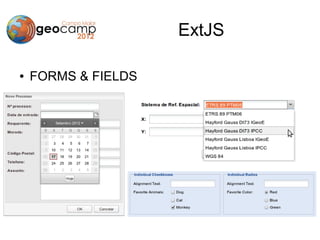
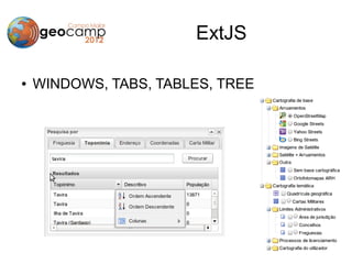
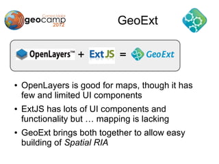
Open Source WebMapping
Architecture
Architecture
Architecture
Architecture

●   Compliance with Standards
●   OSGeo Certified/Incubation
●   Available resources
    –   Documentation
    –   Examples
    –   Articles
    –   Use cases
●   Community activity
●   Personal Preferences
Architecture
Architecture
OpenLayers

●   Javascript API
●   Supports OGC Standards
●   OSGeo Project
●   Big user and developer community
OpenLayers

●   Lots of formats (WMS, WFS, GML, SLD, …)
●   Several map controls (Zoom, pan, TOC, Scale, …)
●   Spatial editing
●
    Interaction with 3rd party services (OSM, Google,
    Yahoo, Bing Maps, Geonames, …)
●   Easy to Learn
●   Nice and useful example galley

                      USE THE SOURCE
OpenLayers

●   MAP
OpenLayers

●   LAYERS
OpenLayers

●   LAYERS
OpenLayers

●   CONTROLS
OpenLayers

●   CONTROLS
ExtJS

●   Javascript API
●   Dual-license
●   Developed and Supported by Sencha
●   Big user community
●   For building Rich Web Applications
●   Rich UI interfaces
ExtJS

●   Lots of fields: numeric, text, date, checbox &
    groups, combobox, fielsets, …
●   Forms and Tables
●   Windows, Panels, Tabs and Trees
●   Animations
●   Dynamic Charting
●   Supports XML, JSON
ExtJS

●   FORMS & FIELDS
ExtJS

●   WINDOWS, TABS, TABLES, TREE
GeoExt


●   OpenLayers is good for maps, though it has
    few and limited UI components
●   ExtJS has lots of UI components and
    functionality but … mapping is lacking
●   GeoExt brings both together to allow easy
    building of Spatial RIA
GeoExt


●   Map in windows, panels and tabs
●   TOC in a tree
●   Map controls in toolbars
●   Feature information in forms, tables
●   Legend Panel
●   Scale Combobox
GeoExt
●   MAP IN WINDOW
GeoExt
●   FEATURES AND TABLES
GeoExt
●   SCALE COMBOBOX AND LAYER TREE
Spatial RIA
Spatial RIA
Conclusions


●   Big diversity of Open Source software
●   Big modularity is an healthy advantage
●   Powerful frameworks available
●   It's fun and easy to learn
●   The big question is:   CAN YOU DO
                           IT???

GeoCamp 2012 - Open Source WebMapping

  • 1.
  • 2.
  • 3.
  • 4.
  • 5.
    Architecture ● Compliance with Standards ● OSGeo Certified/Incubation ● Available resources – Documentation – Examples – Articles – Use cases ● Community activity ● Personal Preferences
  • 6.
  • 7.
  • 8.
    OpenLayers ● Javascript API ● Supports OGC Standards ● OSGeo Project ● Big user and developer community
  • 9.
    OpenLayers ● Lots of formats (WMS, WFS, GML, SLD, …) ● Several map controls (Zoom, pan, TOC, Scale, …) ● Spatial editing ● Interaction with 3rd party services (OSM, Google, Yahoo, Bing Maps, Geonames, …) ● Easy to Learn ● Nice and useful example galley USE THE SOURCE
  • 10.
  • 11.
  • 12.
  • 13.
  • 14.
  • 15.
    ExtJS ● Javascript API ● Dual-license ● Developed and Supported by Sencha ● Big user community ● For building Rich Web Applications ● Rich UI interfaces
  • 16.
    ExtJS ● Lots of fields: numeric, text, date, checbox & groups, combobox, fielsets, … ● Forms and Tables ● Windows, Panels, Tabs and Trees ● Animations ● Dynamic Charting ● Supports XML, JSON
  • 17.
    ExtJS ● FORMS & FIELDS
  • 18.
    ExtJS ● WINDOWS, TABS, TABLES, TREE
  • 19.
    GeoExt ● OpenLayers is good for maps, though it has few and limited UI components ● ExtJS has lots of UI components and functionality but … mapping is lacking ● GeoExt brings both together to allow easy building of Spatial RIA
  • 20.
    GeoExt ● Map in windows, panels and tabs ● TOC in a tree ● Map controls in toolbars ● Feature information in forms, tables ● Legend Panel ● Scale Combobox
  • 21.
    GeoExt ● MAP IN WINDOW
  • 22.
    GeoExt ● FEATURES AND TABLES
  • 23.
    GeoExt ● SCALE COMBOBOX AND LAYER TREE
  • 24.
  • 25.
  • 26.
    Conclusions ● Big diversity of Open Source software ● Big modularity is an healthy advantage ● Powerful frameworks available ● It's fun and easy to learn ● The big question is: CAN YOU DO IT???