Download to read offline
![IJRET: International Journal of Research in Engineering and Technology eISSN: 2319-1163 | pISSN: 2321-7308
__________________________________________________________________________________________
IC-RICE Conference Issue | Nov-2013, Available @ http://www.ijret.org 450
Fig. 2 Micro Watershed map of study area
3. DATA USED
The Survey of India (SOI) topomap nos. 57C /04, 57D/01,
48O/16, 48P/13 topomaps on 1:50000 scale. are used for
delineation of catchment, Micro-watersheds and drainage
map. IRS-1D LISS III 15th December, 2001 and March 15th,
2001 are used for updating drainage map and preparation of
thematic maps. Daily rainfall data for runoff estimation on
daily basis is considered.
4. MORPHOMETRIC ANALYSIS:
Morphometric analysis provides quantitative description of the
basin geometry to understand initial slope or inequalities in the
rock hardness, structural controls, geological and geomorphic
history of drainage basin [Strahler, 1964]. One of the
advantages of morphometric analysis is that many of the
watershed parameters derived are in the form of ratios,
dimensionless numbers, thus providing an effective
comparison irrespective of scale [Krishnamurthy et al., 1996].
The morphometric analysis is the measurement of linear
aspect, areal and relief aspects of drainage basin. The concept
of stream ordering has been outlined by [Horton 1932] and
later amended by [Strahler 1964] to decrease the subjectivity
of drainage analysis. The highest order assigned is 6th order
and hence designated as sixth order catchment. Fig. 3 shows
the stream order map. Moprhomteric characteristics and
parameters estimated are tabulated in Table 1 and 2
respectively.
Fig. 3 Stream order map](https://image.slidesharecdn.com/estimationofmorphometricparametersandrunoffusingrsgistechniques-161226102846/75/Estimation-of-morphometric-parameters-and-runoff-using-rs-amp-gis-techniques-2-2048.jpg)
![IJRET: International Journal of Research in Engineering and Technology eISSN: 2319-1163 | pISSN: 2321-7308
__________________________________________________________________________________________
IC-RICE Conference Issue | Nov-2013, Available @ http://www.ijret.org 452
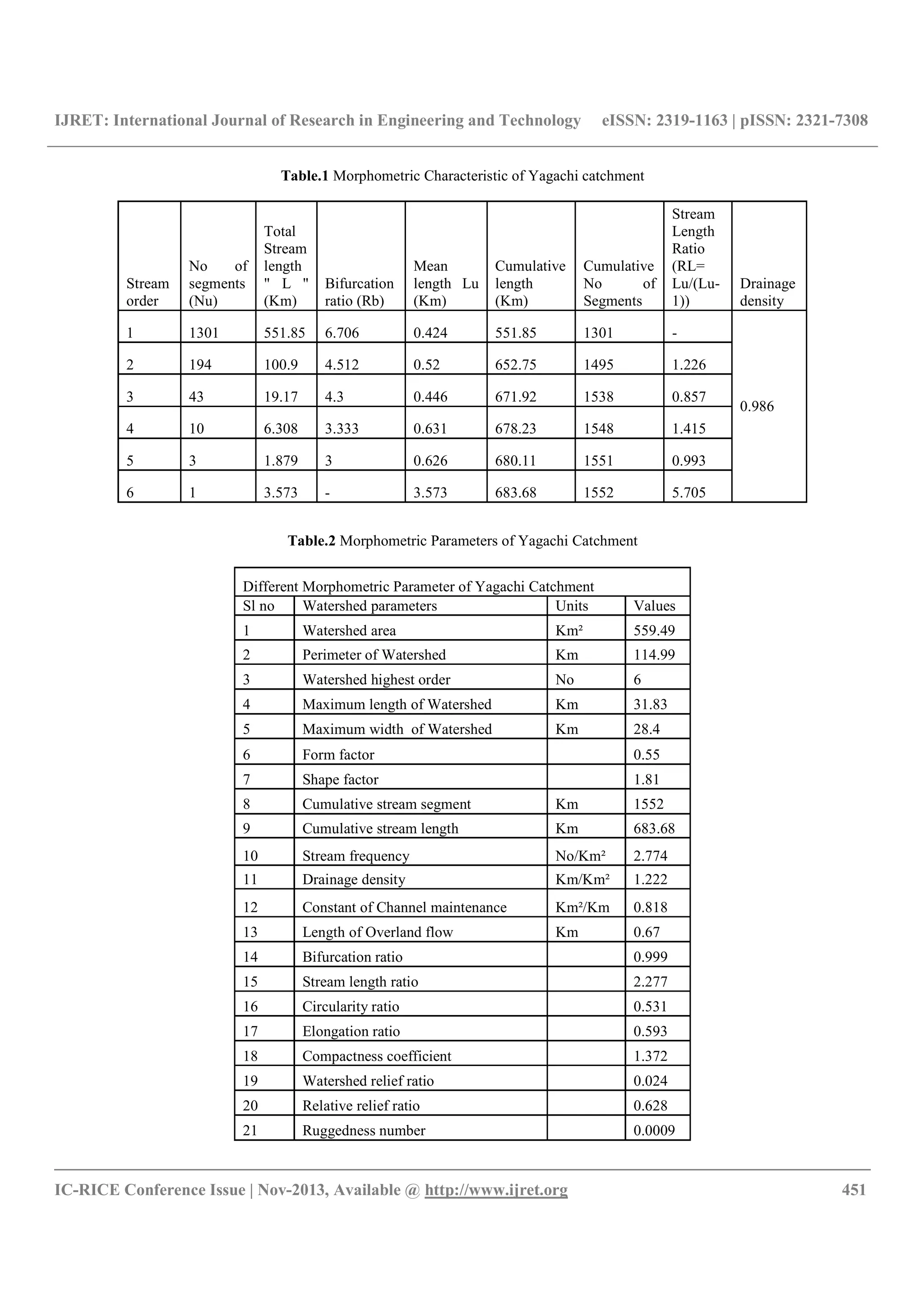
5. RUNOFF ESTIMATION:
Reliable prediction of quantity and rate of runoff from land
surface into streams and rivers is difficult and time
consuming. Conventional models for prediction of river
discharge require considerable hydrological and metrological
data. Collection of these data is expensive, time consuming
and a difficult process. Remote sensing technology has
augmented the conventional methods to a great extent in
rainfall-runoff studies. The curve number method (Soil
Conservation Services, SCS, 1972) also known as the
hydrologic soil cover complex method is a versatile and
widely used procedure for runoff estimation for ungauged
watersheds. McCuen (1982);Stube and Johnston (1990);
Ramaprasad et al. (1993); Ponce and Hawkins (1996)
Nageshwar Rao (2010) have demonstrated the use of SCS
curve number model for runoff estimation. This method
include several important properties of watershed namely soil
permeability, land use and antecedent soil moisture condition.
The SCS curve number method is based on the water balance
equation and developed on two fundamental hypothesis. The
first Hypothesis is expressed as;
Q/(P-Ia)=F/S (1)
where Q is the runoff, P is the rainfall and F is the actual
infiltration and it is the difference between the potential and
accumulated runoff. Ia is the initial abstraction, which
represent all the losses before the runoff begins. S is the
potential infiltration after the runoff begins (S>F). The second
hypothesis is expressed as ;
F= (P-Ia)-Q (2)
Substituting F in eq(1) and rewriting we
get;
Q= (P-Ia)2/
(P-Ia)+S (3)
Where
IA=0.2S (4)
S is spatially distributed variable defined
As
S = (25400/CN)-254 (5)
Curve Number Index (CN) is a relative measure of retention
of water by a given soil vegetation complex and takes on
values from 0 to 100. It is a combination of a hydrologic soil
group and antecedent moisture conditions. The Curve Number
values for AMC-I and AMC-III are obtained from AMC-II
[Ven Te Chow, 1982] by the method of conservation. The
empirical equations used for estimation of CN1 and CN3 are
as follows
CN1=CN2/ (2.281-0.0128CN2) (6)
CN3=CN2/ (0.427+0.00573CN2) (7)
The curve number are assigned on by polygon wise by
overlaying the land use/land cover map and hydrological map
Fig. 4 Land use/Land Cover Map Fig. 5 Hydrological Soil Group map](https://image.slidesharecdn.com/estimationofmorphometricparametersandrunoffusingrsgistechniques-161226102846/75/Estimation-of-morphometric-parameters-and-runoff-using-rs-amp-gis-techniques-4-2048.jpg)
![IJRET: International Journal of Research in Engineering and Technology eISSN: 2319-1163 | pISSN: 2321-7308
__________________________________________________________________________________________
IC-RICE Conference Issue | Nov-2013, Available @ http://www.ijret.org 454
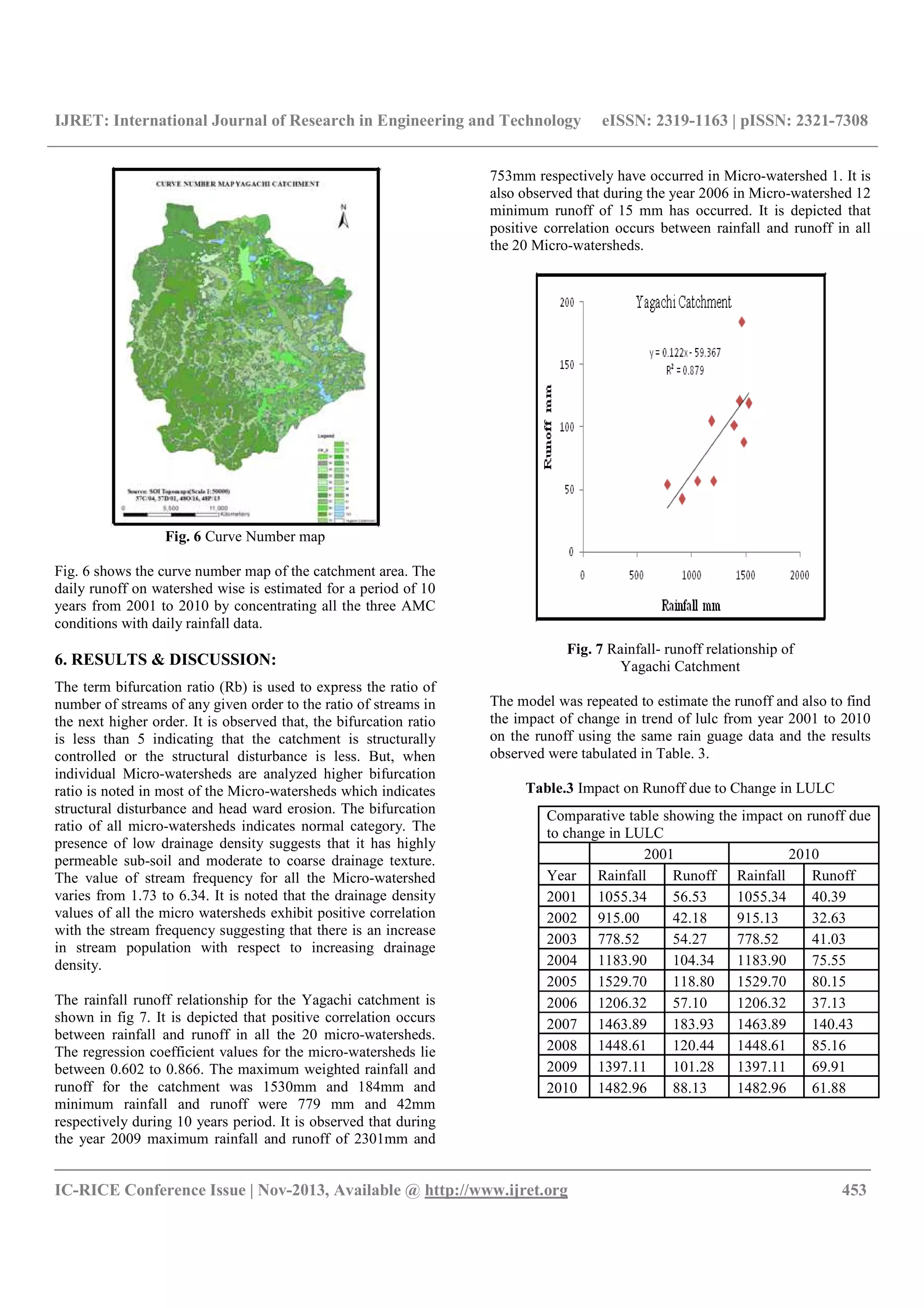
Table.4 Change in the trend of LULC from 2001 to 2010
For Yagachi Catchment
CONCLUSIONS
The catchment is well distributed with tanks which are
basically fed by rain water and the perennial streams which
find its flow due to regenerated irrigation, subsurface flow and
due to presences of Western Ghats from where river
Hemavathi originates. The study has demonstrated that,
remote sensing and GIS has advantages in estimating runoff
from large and ungauged catchments. The drainage density
obtained from the study shows that the catchment is a coarse
textured catchment. Curve number estimation using remotely
sensed data has been shown to be more cost effective than
conventional procedure. The study will serves as an input for
the management of natural resources available within the
watershed. The maximum and minimum runoff estimated for
individual micro watershed during the period 2001 to 2010 is
2310 mm and 15mm respectively. The observed inflow is
more than the estimated runoff, this is mainly due to
continuous irrigation, seepage from the agricultural land and
lateral flow causing in the catchment area.
REFERENCES
[1]. Horton, R. E (1932) Drainage basin characteristics,
Transaction of the American Geophysical Unions, 13, pp. 350-
361.
[2]. McCuen, R. H (1982), A Guide to Hydrologic Analysis
using SCS Methods, Prentice Hall Inc., New Jersey.
[3]. Nageshwar Rao. K, Swarna Latha. K ., Arunkumar. P and
Harikumar, M (2007) Marphometric Anlysis of Geostani
River Basin in Andhra Pradesh State, India usning Spatral
Information Technology, Indian Journal of Geomatics and
Geosciences, Vol-1, No.1, pp. 179-187.
Abstract of LULC for Yagachi catchment
SI
No LULC-Level-3 Area(2001) Area(2010)
1 Agricultural Plantation 171.718 164.822
2 Barren Rocky / Stony Waste / Sheet Rock Area 2.185 0.164
3 Degraded Forest 0.832 4.671
4 Dense Grass land / Grazing land 1.644 12.953
5 Fallow land 3.978 8.92
6 Forest Plantations 1.945 0.161
7 Habitation with Vegetation 5.436 40.007
8 Kharif + Rabi (Double Crop) 48.822 38.953
9 Kharif crop 253.14 192.87
10 Lake / Tanks 12.41 2.745
11 Reservoir/Rivers/streams 2.016 0
12 Land with scrub 12.465 10.987
13 Mining / Industrial Wasteland 0.074 0
14 Mixed Vegetation 4.01 5.89
15 Moist & Dry Deciduous Dense Forest 4.712 3.921
16 Moist & Dry Deciduous Open Forest 1.243 6.723
17 Town / Cities/Villages 20.58 6.328
18 Tree Groves 12.282 37.588
19 Tanks without water 0 21.791
TOTAL 559.493 559.494](https://image.slidesharecdn.com/estimationofmorphometricparametersandrunoffusingrsgistechniques-161226102846/75/Estimation-of-morphometric-parameters-and-runoff-using-rs-amp-gis-techniques-6-2048.jpg)
![IJRET: International Journal of Research in Engineering and Technology eISSN: 2319-1163 | pISSN: 2321-7308
__________________________________________________________________________________________
IC-RICE Conference Issue | Nov-2013, Available @ http://www.ijret.org 455
[4]. Ponce, M Victor and Hawkins H Richard (1996) Runoff
Curve Number; Has it Reached Maturity Journal of Hydraulic
Engineering, ASCE (1), pp. 11- 19.
[5]. Rama Prasad, Sridharan, K., and Vedula, S (1993), Runoff
Estimation for small ungauged catchments, Report Prepared
for Chief Engineer (Minor Irrigation), Govt- of Karnataka,
India.
[6] Ravikumar, A. S, (2001), Water Balance Components
from Field Studies using Remote Sensing and Geographical
Information System, Ph. D Thesis, Indian Institute of Science,
Bangalore
[7].Soil Conservation Services, (1972), National Engineering
Handbook, Hydrology, Section 4, Chapter 4 to 10.
[8].Strahler, A. N (1964) Quantitative Geomorphology of
Drainage basin and channel Network. Hand book of
Hydrology edited by Ven Te Chow, McGraw Hell section 4-
11.
[9].Stube, M. M and Johnston, D. M (1990) Runoff Volume
Estimation Using SCS Techniques, Water Resources. Bull., 26
(4), pp. 611-620.
[10].Ven Te Chow (1982) Handbook of Applied Hydrology,
McGraw Hill Book Company.](https://image.slidesharecdn.com/estimationofmorphometricparametersandrunoffusingrsgistechniques-161226102846/75/Estimation-of-morphometric-parameters-and-runoff-using-rs-amp-gis-techniques-7-2048.jpg)

This document summarizes a study that used remote sensing and GIS techniques to estimate morphometric parameters and runoff for the Yagachi catchment area in India over a 10-year period. Morphometric analysis was conducted to understand the hydrological response at the micro-watershed level. Daily runoff was estimated using the SCS curve number model. The results showed a positive correlation between rainfall and runoff. Land use/land cover changes between 2001-2010 were found to impact estimated runoff amounts. Remote sensing approaches provided an effective means to model runoff for this large, ungauged area.


