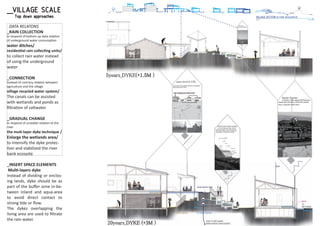
01/ ECO-CHOROGRAPHIC MAP
2013 GRADUATION THESIS
Second Prize-International Climate Adaptation Design Competition 2014
Top prize-Superior graduation design 2013
Silver Award-The forth cross-Strait Young Talent Award of Architecture2013
Top prize- (young talent) The national golden award for architecture 2013
Advisor: Bart van Bueren
bartvanbueren@gmail.com
Location: Chong-Tsao village, Southwest coast
Program: Community
INTRODUCTION
Climate change has been causing instability of the development of the coastal area.There-
fore I propose the renovation of the coastal villages by the villagers should form a new
resilient landscape to face the climate issue.
bigger scale data
smaller scale data
deductive data
(closely-related)
deductive data
(closely-related)
spatial difference
or
category difference
addable
Data’s name
Location
Description
Diagram
bigger scale data
smaller scale data
deductive data
(closely-related)
deductive data
(closely-related)
spatial difference
or
category difference
SCALE
0M
100M
200M
300M
117° 118° 119° 120° 121°
summer current
winter current
agriculture use on river bank
no protecting sand bank
low dyke
$
$
$
production sale
reastic sale
Southern Taiwan Science Park
Local Factory
Oyster Farm
Aquaculture
serving areas
SPATIAL DIFFERENCE
+
+
-
+
+
-
0
0
+
+
0
-
0
+
-
-50
+, -, 0
DESIGN STRATEGY
PROCESS
_METHODOLOGY
Modularization of the cylcles
Deduction of the data map
In our Living space, people consciously,
unconsciously build up many different
aspects and scales of circular systems. For
the existing coastal villages to achieve
coexistence with the environment in the era
of climate changes, the circular systems in
the coastal area must be resilient and
create a well-knitted network, or so to say
“an along coast sustainable eco-web”.
According to my aspect, I began develop a
methodology to observe various scales of
circulations in the environment, and find out
local characters and coastal resources that
have the potential abilities to accept storm
surge.
02Relationship between the circular units
03Modularization_
clarified the relationships between the circular
units by giving it the shape of Hexagon.
04Visualization
01Classification of the cycles
05Evaluation
06Deduction of the data map
(Dung-shr)
SCALE
Technique
Building
Street
Village
Region
Delta
Yan-shui
River
Ceng-wen
River
Ba-zhang
River
Bei-gang
River
Zhuo-shui
RiverSouth North
(Dung-shr)
2
1.5
1M
(MM)123456789101112
yunlin
15
30-
Meanhighwatersprings
Rainfall
Temperature
15
30-
Meanhighwatersprings
Rainfall
Temperature
2
1.5
1M
(MM)123456789101112
chayi
Temperature
15
30-
Meanhighwatersprings
Rainfall
Temperature
2
1.5
1M
(MM)123456789101112
peiman
15
30-
Meanhighwatersprings
Rainfall
Temperature
2
1.5
1M
(MM)123456789101112
anain
Subsidence area
- the delta middle part’s soil is easily
compressed(silt, clay)and pumping
wells are concentrated here.
Most sunken areas,the middle land
Subsidence area
- Long-term pumping of groundwater
f farms caused the zero water
line has displaced at least 13 km/40yrs
Most sunken areas,the middle coast
Subsidence area
- groundwater in the coastal towns
containing arsenic, high salt, high
quality standards.
4.3cm/year, 29km2 for 3cm/y
Subsidence area
- The factories and aquaculture extract
groundwater use.
5.5 cm/year, 10.19km2(3cm/y
biodiversitybiodiversitybiodiversitybiodiversity
yun-lin
a narrow ribbon of wetlands along
the south coast
dykes
yun-lin
long dykes along the coast
riversriversriversrivers
yun-lin
zhuo-shui river(long) in the north
hu-wei river(short) cover the south
weatherweatherweatherweather
yun-lin
got the highest mean high water spring
yun-lin
re moving inward
following the subsidence spots
dykes
Jia-yi
+the weakest dyke would be the south
end, however it is accompany with
wetlands
Jia-yi
re moving inland
dykes
beiman
the lagoon along the coast replaced
the dykes
beiman
gathered in the north part
dykes
Annan
ceng-wen river(long) in the north
polluted in the middle part
Annan
a bite warmer in the summer
annan
located in the inner land where there
are more deep wells
+there are large area of wetlands at
the north&south end
there are wetlands beside the river
mouth+si-cao wetland is well preserved
Pilings by the canal
Firm the soil beside the canal
+cheap
+fast to build
- can’t last long
Pipe columns
+protect itself from sea wind erosion
Windbreak
Pilings by the canal
prevent the canal from crashing in
Working house
+protect itself from sea wind erosion
Windbreak
decrease wind speed, prot
pond from direct damage
po zi rivers
po zi river carried great amount of sand
ba zhang river is seriously polluted
got the lowest mean high water spring
the rising of the aquaculture adding
the need of underwater and the sea
water
water usage
feature landscapeLanduse
Jia-yi
small&big villages with harbors
spreading along the coast
Jia-yi
agriculture44mile^2
aqualculture20mile^2
three feature landscape along the
coast sandbanks, wetlands, inner sea
po zi rivers
po zi river carried great amount of sand
ba zhang river is seriously polluted
most villages only have a dyke to
stools outside
stools are handy and used for work
or relax
好美)village
River bank stones
+shaped by river
massive clam shells were dumped
by plp
Yan-shuei(鹽水)river bank
there are two layers of concrete added
Wen-gang(塭港)Harbor
ba zhang riverand ji-shui river are in
the north both quite polluted
the dykes along ceng-wen river are
predicted to be too low in the future
water wheel
tr zags net
in the middle of the river
moves ar to
create oxygen.
-consumes great amount of electricity
+easy to move around
green space by canals
rssun sheltersun shelter
aquaculture wood dock
beiman
creat
beiman
+now use as tourist spot and the
farmers become narrators
shading arbor
Annan
reduce the heat
-hard to decompose
Annan
+low cost
annan
the amount of underwater and
electricity used in the process
the unused ponds have gradually turn
in to wetlands
the farmer plants some Calla lilies
the biodiversity of the rivermouthusually use in sea to de rea,
photos
beside the gar to
put tools
by the ceng-wen river
the river banks are used as agriculture
ceng-wen river mouth
sun shelter
a daily schedule of
a aquaculture woman
by the ceng-wen river
there are no green plants along the
river banks causing the sand storm
Annan
there are no sandbank outsides the
coast the wetlands help to protect the
by the ceng-wen river
+harvest one&two ponds a year
raise clams shrimps along the edge the erosion
the woman get a home OEM job
to earn more money
Harbor height level
lines, adjusted with block
Wen-gang(塭港)Harbor
Oyster frames
between sandbank and coast are good
from sandbank to coast
set up shelter in front of the house as
working place
Wen-gang(塭港)village
worked as windbreak and conserved
the soil
東石)newland
tree
from the village to shore are layers of
aquacultures, wetlands and dykes
好美)village
from coast to village
almost no bu er zone from the river to
the dyke
北港)river mouth
Pei-gang(北港)river
L/ Westside from Pei-gang(北港)
river mouth
Waisanding(外傘頂)
the village was protected by
the wetland out ring
L/ between Yan-shuei(鹽水)&
巴掌) river
好美)village
Aquaculture occupied the river mouth
L/the boundary of Chia-yi&Yu-lin
Pei-gang(北港)
sandbank river mouth
village types Sandbanks
yun-lin coastal area
the high ways are closed to the harbor
and the bigger villages along coast
roads
coast lineLanduse
L/ yun-lin coastal area
villages distribute along highway
L/ yun-lin coastal area
the villages are in the middle of
agriculture &aquaculture
man-built island and shore in the north.
narrow, close-to-land sandbanks
along the coast
L/ yun-lin coastal area
the erosion of tai-xi newland
L/ yun-lin coastal area
- 10villages are in the middle of
agriculture &aquaculture
L/ yun-lin coastal area
village types feature landscape
Beiman-Qi gu coast
roads
feature landscapeLanduse
Beiman-Qi gu coast
small&big villages located along
17 highway(second large)
Beiman-Qi gu coast
beiman district has bad resilient
quality
lagoons along the coast
two big wetlands at two ends
the sand source from ba zhang river&
ceng-wen river wind&current shaped
the sandbank
10 villages located behind the highway
village types coast line
+the bikeways are organized alone
the coast(bad quality)-main roads
are higher than the land
roads
VulnerabilityLanduse
slowly growth with the rate of 0.75%
+absorb the urban sprawl
Industrial zone is mostly in
coastal area(3.55mi2)
salt water intrusion in coastal area
(weak soil) -the tseng-wen river bank
became agriculture land instead of
wetland -there are less sandbank
outside the coast
the detour of ceng-wen river in 1823
turn the inner sea into landTainan city - plp in coastal area gather
in two villages 港西 台江
landscape
+the lagoons along the coast protect
the land from erosion there are more
agricultur coastal area
coastagriculture trading
Jiang-jun village
-its fuel consuming to get to bigger
town+self grow products in the
backyard
Jiang jun
wholesalers control the incomes of
the farmers
many agricultur re seen
because lagoons along the coast
to protect the land from erosion
the inner sea creates a bu er zone
for sea water&neutral water
here are plants on the sandbank the sandbank are closed to the land
+the water inside are more steady for
oysters
north coasta day of a oyster lady
coast of yun-lin
-its fuel consuming to get to bigger
town+self grow products in the
backyard
middle coast of yun-lin
mullets will be transported to a bigger
center there will be more workers to
help take out the roe
re abandoned because
of the erosion they are gradually take
over by the wetlands
the length of the wetlands view fromthe living space and the working space
ZHUO-SHUI RIVER
BEI-GANG RIVER
BA-ZHANG RIVER
CENG-WEN RIVER
YAN-SHUI RIVER
SOUTH-WEST COAST
OF TAIWAN
Yan-shui
River
Ceng-wen
River
Ba-zhang
River
Bei-gang
River
Zhuo-shui
River
Landscape pattern development
PLANTING
SOIL CONSERVATION
POLLUTION FREE
BIODIVERSITY
FUEL USE
RESILIENCE
0 +1-1-3-4-5-6-7 -2 +2 +4 +6 +7 +8 +9 +10+5+3
TOTAL
PRODUCTION
LIVING
NATURE
-1.5M
-1.5M
SOISOIL CONSEL CONSEL TION
POLLUTION FREEPOLLUTION FREE
BIODIVERSITYBIODIVERSITY
PLANTINGPLANTING
PLANTING
SOIL CONSERVATION
POLLUTION FREE
BIODIVERSITY
FUEL USE
RESILIENCE
0 +1-1-3-4-5-6-7 -2 +2 +4 +6 +7 +8 +9 +10+5+3
PRESENT STATE
TOTAL
MEASURES
POTENTIAL QUALITIES
TOTAL
PRODUCTION
LIVING
NATURE
PLANTING
SOIL CONSERVATION
POLLUTION FREE
BIODIVERSITY
FUEL USE
RESILIENCE
0 +1-1-3-4-5-6-7 -2 +2 +4 +6 +7 +8 +9 +10+5+3
TOTAL
PRODUCTION
LIVING
NATURE
-3M
-3M
+3
PLANTING
SOIL CONSERVATION
POLLUTION FREE
BIODIVERSITY
FUEL USE
RESILIENCE
0 +1-1-3-4-5-6-7 -2 +2 +4 +6 +7 +8 +9 +10+5+3PRESENT STATE
TOTAL
MEASURES
POTENTIAL QUALITIES
TOTAL
PRODUCTION
LIVING
NATURE
+5
PRESENT STATE PRESENT STATE
PRESENT STATE
PRESENT STATE
(Dung-shr)(Dung-shr)
Subsidence area
- the delta middle part’s soil is easily
compressed(silt, clay)and pumping
wells are concentrated here.
Most sunken areas,the middle land
Subsidence area
- Long-term pumping of groundwater
line has displaced at least 13 km/40yrs
Most sunken areas,the middle coast
Subsidence area
- groundwater in the coastal towns
containing arsenic, high salt, high
quality standards.
Subsidence area
- The factories and aquaculture extract
groundwater use.
rivers
Annan
ceng-wen river(long) in the north
polluted in the middle part
Working house
for the farmer store the tools and
forage
the rising of the aquaculture adding
the need of underwater and the sea
water
water usage
Landuse
Jia-yi
agriculture44mile^2
aqualculture20mile^2
-most villages only have a dyke to
there are two layers of concrete added
Wen-gang(塭港)Harbor
sun shelter
aquaculture
Annan
+low cost
annan
the amount of underwater and
electricity used in the process
by the ceng-wen river
the river banks are used as agriculture
ceng-wen river mouth
by the ceng-wen river
there are no green plants along the
river banks causing the sand storm
the erosion
Harbor height level
village types
coast lineLanduse
L/ yun-lin coastal area
the villages are in the middle of
agriculture &aquaculture
man-built island and shore in the
north
narrow, close-to-land sandbanks
along coast
L/ yun-lin coastal area
the erosion of tai-xi newland
L/ yun-lin coastal area
feature landscape
+the bikeways are organized alone
the coast(bad quality)-main roads
roads
VulnerabilityLanduse
Industrial zone is mostly in
coastal area(3.55mi2)
salt water intrusion in coastal area
(weak soil) -the tseng-wen river bank
became agriculture land instead of
wetland -there are less sandbank
outside the coast
the detour of ceng-wen river in 1823
turn the inner sea into land
landscape
CONTRARY RELATIONS
FACTOR:the village & the environment
FACTOR:Cheng-wen river
TOP-DOWN RELATIONS
FACTOR:artificial landscape transformation
BOTTOM-UP RELATIONS
FACTOR:aquaculture
UNSTABLE RELATIONS
DATA RELATIONS_ECOSYSTEM MAP
Data relations
Landscape pattern
In each ecosystem map, the data can be
deducted into Landscape pattern and Data
relations. The Landscape patterns are
develop by enhancing resilient landscape and
remedy the anti-eco friendly circulations. In
data relations, there are “top -down” ,
”bottom-up” , “unstable” and “contrary”
relations to describe how the costal
elements affect one another.
In this research the deduction of the data
map are “southwest-coastal map→ Annan
region map → Ching-Tsao village map”. (In
the data map making process, the map can
be scale down according to the location of
the site ex. southwest-coastal map→ Dong-
shi Township map →Wangliao village map)
Form zhuo-shui river
to yan-shui river
1 Enlarge the
buffer zone
2 Stabilize the
sediment supply
of sandbanks
3 Collect the rain
as water resource
1 Bottom-up Relations
of The aquaculture
2 Top-down Relations
of artificial landscape
transformation
3 Unstable Relations
of Cheng-wen river
01 Landscape
Pattern
_Southwest coast
02 Data Relations
_DELTA MAP
SCALE
Technique
Building
Street
Village
District
Delta
15
30-
Meanhighwatersprings
Rainfall
Temperature
2
1.5
1M
(MM)123456789101112
Temperature
zone1 zone2 zone3 zone4
OYSTER BUSINESS
SEA DYKE
WETLANDS
AQUACULTURE
RIVER DYKE
RIVER
PRODUCTION
DISASTER PREVENTION
RELIGION
FACTORIES
EVERYDAY LIFE
ECO-TOURISM
sun sheltersun shelter
(蜈蚣陣)
L/ tour in the coastal area
the tour group is form by village’s kids,
dressed up like solders from sky to
keep away plagues
L/coastal area
I farming industry(most)
II manufacture industry
III service industry
L/ Ceng-wen river mouth
north
Sea dyke
L/ near the Ceng-wen river mouth
there are a stones base in front of
the dyke, not only reduce the wave
but also environmental friendly
(oysters)
L/ inner harbor of Lu-re-men river
the head of the machine can turn
carried the goods from boats to
the ground
L/ by the green grass hill village
there is no bu er to reduce to wave
outside the dyke
L/ Ceng-wen river mouth
water rush out river mouth
carried with mud
aquaculture
L/Ma-zu –gong village
most of the people rela
ponds to make the ends meet
main road
L/ lu-ar-mon village
the villager said the water drainage
away form the main road, which is
sloping to the river
small temple
L/ surround the
green grass hill village
in the 外五營 area(area outside the
temples area)ppl set up small temples
to keep away misfortunes and ghosts
local factory
L/Si-cao village
there are some small factories
found in the village which store
a lot of goods in the Metal store
houses
Tetrapod
L/near the Ceng-wen river mouth
the Tetrapods are used to reduced the
wave height
Styrofoam blocks
L/ inner harbor of Lu-re-men river
the blocks are used to support the net
and frames t at
abandon ponds
L/ Ceng-wen river front riverbank
abandon ponds became wetlands
created biodiversity and conserved the
soil
L/ near Ceng-wen river mouth
moves ar to
the stones layers give a chance for
abandon ponds
L/ Ceng-wen river front riverbank
abandon ponds became wetlands
created biodiversity and conserved the
soil
front yard farm
L/ Xian-gong village
grow some organic vegetable
and raise chickens
speaker
L/ lu-ar –mon village
through the speaker, Borough chief
Pigeonry(鴿舍)
the pigeonry is built on the roof
or stand on its own
It’s a common site in every village
water gate
L/the end of the village main road
control the water in & out
Tu-cheng Maz
L/ green grass hill village
(protected by) the Tu-cheng Mazu
worship group
L/ in the metal parts factory
goods
dykes
the dykes along ceng-wen river are
predicted to be too low in the future
Subsidence area
The factories and aquaculture extract
groundwater use.
L/Annan
was built, the irrigated area increased
and accelerated the hydro-form land
process
5.5 cm/year, 10.19km2(3cm/y
rivers
weather
Annan
ceng-wen river(long) in the north
polluted in the middle part
Annan
the mean high water spring are less
stable compare to chia-yi, yu-lin
L/ coast of Annan
the trucks will go to the local
the goods by high way61
L/Tainan coast
in 1600s the lands used to be
lagoons and inner sea
in 1800s the lands started to appear
L/ coast of annan
they are mos
wher re distributed
sandbanks
L/southwest coast
there are sandbanks,
lagoons cover up the coast
excluded Annan coast
the coastal shape
L/ southwest coast
from the trace of coast line
ceng-wen river carried great amount
of soil to the shore
annan
located in the inner land where there
are more deep wells
religion
L/Annan region
the coastal area people mostly
worship Mazu(sea god)
people lived in the inner side
worship 保生大帝(health god)more
industrial area
L/south west coast
in comparison
there are more journals and news
about yu-lin industrial area’s
impact on the environment
living space
L/ Annan district
the living spaces gather
in the edge of Tainan city
the living space
green space by canalsshading arbor
Annan
reduce the heat
-hard to decompose
Annan
+low cost
the farmer plants some Calla liliesbeside the gar to
put tools
by the ceng-wen river
the land of aquacultures area
are lower than the living area
ceng-wen river mouth a daily schedule of
a aquaculture woman
there are no sandbank outsides the
coast
the wetlands help to protect the land
Green tunnel
L/ coast Si-cao village
it’s a wetland area by the coast
a sightseeing route was planned
by the ceng-wen river
+harvest one&two ponds a year
raise clams shrimps along the edge the erosion
The detour of
Ceng-wen river
the detour of the river
restricted the villages from developing
L/annan north coast
the woman get a home OEM job
to earn more money
Taijang river tour
there are lots of Mangroves by
the river
L/ Si-cao village
Tainan technology
industrial zone
science park, there are more
industrial plants in this area
L/Xian-gong village
-main roads are higher than the land
Roads system
Vulnerability Landuse
slowly growth with the rate of 0.75%
+absorb the urban sprawl
L/ coast of An-nan
Industrial zone is mostly in
coastal area(3.55mi2)
L/coastal Annan
it’s a on the go project in the
urban planning guide
the coastal area will be natural
salt water intrusion in coastal area
(weak soil) -the tseng-wen river bank
became agriculture land instead of
wetland -there are less sandbank
outside the coast
Tainan city - plp in coastal area gather
in two villages 港西 台江
bike around the coastal area and
visit the sights
L/ Annan coast
by the ceng-wen river
there are no green plants along the
river banks causing the sand storm
L/zheng-zi-liao village
the border between the two areas
are blur
L/between the lu-ar-mon river
& lu-ar-mon village
built recently
drainage out the water in the village
lu-ar -mon MAZU temple
L/ lu-ar –mon village
blessed by MAZU
Koxinga(鄭成功)landed from this
place and proclaimed the land back
from the Dutch
L/by the green grass hill village
the detour of ceng-wen river in 1823
turn the inner sea into land
the detour of river
biodiversity
+si-cao wetland is well preserved
the oysters frames
distribution
there are lagoon along the Qi-gu coast
which created a wonderful place
for oysters business
L/Annan& Qi-gu coast
the formation of land
carried more soil than the others
L/Tainan
water wheel
moves ar to
create oxygen.
-consumes great amount of electricity
+easy to move around
water pumps
L/ by the green grass village
there are swallow & deep water pumps
swallow water pumps are not the cause
of subsidence
the form living spaces in the west
L/Annan
the coastal area of annan is part
of the southwest scenic area
southwest coast
L/southwest coast of Taiwan
water cycle of
agriculture
L/ Annan region
most of the source supply by the
reservoir
the water are polluted in the
upper stream
it’s important that river could be
cleaned by itself
2100disaster risk scena-
riofrom water resources
agency
L/Annan coastal area
the river and the aquaculture area are
predict t
religion
L/ Annan region
villages will grouped up together and
worship the most popular god such as
Mazu(sea godness in Tu-cheng)
government’s plan
L/ Annan region
park
the oysters
L/ the coast & river front of Annan
located in the salt&semi-salt water area
also as the claimer water area
excluding the ceng-wen river mouth
water supply of
agriculture
L/ north coast of Annan
there are two aqueducts as water
source, however water turn slat near
the coast there seem to be no wet
wetlands
L/behind the green
grass hill sea dyke
the wetlands are capable of
r ov ow
the dyke
green grass dyke safety
L/ northern coast and the south
part of Ceng-wen riverbank
the wave height will reach 6.5M in the
future. The green grass dyke are 5M he
ight in average
rge
in 1992
L/ Ceng-wen river
great amount of water released
(4000 cm/s)
villages
L/annan coast
there are six small villages and
a big one.
two of them are near to coast
with wetlands in front
L/ coastal area of Annan
the schools served as emergency shelt-
ers most of them didn’t located in the
high ground
religion in coastal area
L/ Annan coast
the popular gods are王爺-plague god
Mazu-sea goodness, 保生大帝 health
god, the religion maybe related to the
factories area distributed
along the main roads
the small factories are in
factories
L/annan
the work schedule
L/ the coast and river front of Annan
they work during the rising and
green grass ocean dyke
there are three types of technique
it more natural tech when it goes south
L/ the north coast of Annan
north coast
L/ between
Ceng-wen river&Lu-re-man river
near the river mouth the sand shore is
obviously declining
the water supply
L/ coast of annan
the source of the neutral water come
from the deep underground causing
the subsidence
villages
L/ coast of Annan
Tu-cheng is the biggest town in the area
grocery, food, religion center
L/Annan coastal area
the temples, rich in history&
tourism spots
industry types
L/ coast of Annan
the aquaculture and the oyster
business are the main industry here
the concrete dyke near the river mouth
L/ the north coast of Annan
inner harbor
a harbor parked with lots of
oysters boats, surrounded by
the working houses
L/Lu-re-men river mouth
the coast line
the south part is moving forward
the north part slightly declined
L/ between
Ceng-wen river&Lu-re-man river
L/ green grass village
no bu er zone, the ground
level of the school is no higher
day schedule of
a oyster female farmer
L/ green grass hill village
everyday
L/ near the Lu-re-man river L/near the Ceng-wen river mouth
the shore ecology has its own system
to purify the water and provide
ZONE1 COAST
ZONE2 SOUTH BANK OF THE CENG-WEN RIVER
ZONE3 THE LU-ER-MAN RIVER SIDE
ZONE4 NORTH BANK OF THE YAN-SHUI RIVER
ZONE 1
ZONE 2
ZONE 3
ZONE 4
zone1 zone2 zone3 zone4
PLANTING
SOIL CONSERVATION
POLLUTION FREE
BIODIVERSITY
FUEL USE
RESILIENCE
0 +1-1-3-4-5-6-7 -2 +2 +4 +6 +7 +8 +9 +10+5+3
TOTAL
AQUALCULTURE
DYKES
RIVER
PLANTINGPLANTING
LL CONSEL CONSEL TION
POLLUTION FREEPOLLUTION FREE
BIODIVERSITYBIODIVERSITY
0
BIODIVERSITYBIODIVERSITY
FUEFUEL USEL USEL
+4 PLANTING
SOIL CONSERVATION
POLLUTION FREE
BIODIVERSITY
FUEL USE
RESILIENCE
0 +1-1-3-4-5-6-7 -2 +2 +4 +6 +7 +8 +9 +10+5+3
TOTAL
PRODUCTION
DISASTER PREVENTION
RELIGION
PLANTINGPLANTING
CONSECONSER
POLLUTION FREEPOLLUTION FREE
-5
PLANTING
SOIL CONSERVATION
POLLUTION FREE
BIODIVERSITY
FUEL USE
RESILIENCE
0 +1-1-3-4-5-6-7 -2 +2 +4 +6 +7 +8 +9 +10+5+3
TOTAL
FACTORIES
LIVING
ECOLOGY RECREATION
TIONTION
POLLUTION FREEPOLLUTION FREE
BIODIVERSITYBIODIVERSITY
PRESENT STATE
POTENTIAL QUALITIES
CONCLUSION
PRESENT STATE PRESENT STATEPRESENT STATE
POTENTIAL QUALITIESPOTENTIAL QUALITIES
PLANTING
SOIL CONSERVATION
POLLUTION FREE
BIODIVERSITY
FUEL USE
RESILIENCE
0 +1-1-3-4-5-6-7 -2 +2 +4 +6 +7 +8 +9 +10+5+3
TOTAL
PRODUCT(OYSTER)
DYKES
WETLAND
0 +1-1-3-4-5-6-7 -2 +2 +4 +6 +7 +8 +9 +10+5+3
POTENTIAL QUALITIES
PLANTINGPLANTING
POTENTIAL QUALITIES
L/ Ceng-wen river mouth
water rush out river mouth
carried with mud
aquaculture
L/Ma-zu –gong village
ponds to make the ends meet
Tetrapod
L/near the Ceng-wen river mouth
the Tetrapods are used to reduced the
wave height
dykes
the dykes along ceng-wen river are
predicted to be too low in the future
Subsidence area
The factories and aquaculture extract
groundwater use.
rivers
Annan
ceng-wen river(long) in the north
polluted in the middle part
sandbanks
L/southwest coast
there are sandbanks,
lagoons cover up the coast
excluded Annan coast
annan
located in the inner land where there
are more deep wells
industrial area
L/south west coast
in comparison
there are more journals and news
about yu-lin industrial area’s
impact on the environment
by the ceng-wen river
the land of aquacultures area
are lower than the living area
ceng-wen river mouth
the erosion
Tainan technology
industrial zone
science park, there are more
industrial plants in this area
L/Xian-gong village
-main roads are higher than the land
Roads system
Vulnerability Landuse
L/ coast of An-nan
Industrial zone is mostly in
coastal area(3.55mi2)
salt water intrusion in coastal area
(weak soil) -the tseng-wen river bank
became agriculture land instead of
wetland -there are less sandbank
outside the coast
by the ceng-wen river
there are no green plants along the
river banks causing the sand storm
the detour of ceng-wen river in 1823
turn the inner sea into land
the detour of river
water pumps
L/ by the green grass village
there are swallow & deep water pumps
swallow water pumps are not the cause
of subsidence
water cycle of
agriculture
L/ Annan region
most of the source supply by the
reservoir
the water are polluted in the
upper stream
it’s important that river could be
cleaned by itself
2100disaster risk scena-
riofrom water resources
agency
L/Annan coastal area
the river and the aquaculture area are
green grass dyke safety
L/ northern coast and the south
part of Ceng-wen riverbank
the wave height will reach 6.5M in the
future. The green grass dyke are 5M he
ight in average
in 1992
L/ Ceng-wen river
great amount of water released
(4000 cm/s)
factories area distributed
along the main roads
the small factories are in
factories
L/annan
the water supply
L/ coast of annan
the source of the neutral water come
from the deep underground causing
the subsidence
the concrete dyke near the river mouth
L/ the north coast of Annan
groundwater use.
CONTRARY RELATIONS
FACTOR:unstable environment&
industrial developement
UNSTABLE RELATIONS
FACTOR:the discharge and sediment load
BOTTOM-UP RELATIONS
FACTOR:water pumps
_ECOSYSTEM MAP
Data relations
Landscape pattern
01 Landscape
Pattern
_Annan region
1 Multi-layer dyke
2 Adding wetlands
3 Connecting canals
to the abandon po-
nds&water ditches
1 Bottom-up: factor
data_Pumping of
groundwater
2 Contrary: factor
data_Unstable en-
vironment&indust-
rial developement
3 Unstable: factor
data_the discharge
and sediment load
Choose Annan region,
where multi-problems
lies in, as the next
research site.
02 Data Relations
rivermouth dyke section
L/ near Ceng-wen river mouth
moves around in the fish pond to
the stones layers give a chance for
plantings to crawl on the dyke
_REGION MAP
crucial data
in region map
MULTILAYERS DYKE
zone1 zone2 zone3 zone4
15
30-
Meanhighwatersprings
Rainfall
Temperature
2
1.5
1M
(MM)123456789101112
Temperature
PRODUCTION
PUBLIC FACILITY
PHISICAL
ENVIRONMENT
GREEN SPACE
FACTORIES
COMMUNITY
RIVER DYKE
AQUACULTURE
AGRICULTURE
RELIGION
RIVER
OYSTER
BUSINESS
CONNECTION
WETLANDS
SEA
DYKE
the oysters
L/ the coast & river front of Annan
located in the salt&semi-salt water area
also as the claimer water area
excluding the ceng-wen river mouth
roads system
L/ coast of Annan
+ the bikeways are organized alone the
coast(bad quality)
- main roads are higher than the land
biodiversity
L/ coast of Annan
+si-cao wetland is well preserved
dykes
L/ coast of Annan
there are wetlands behind the dyke in
the upper part
and the work schedule
L/ the coast & river front of Annan
they work during the rising and falling
oyster business
L/ ceng-wen river mouth
the coastal residents
day schedule of
a oyster female farmer
L/ green grass hill village
everyday
oyster frame making
L/ the ceng-wen river
made of bamboos, it’s heavy however
one another by hand
L/ the ceng-wen river
lightly touch the ground
used by oyster farmer to tour on the
frames
villages
L/ coast of Annan
Tu-cheng is the biggest town in the area
grocery, food, religion center
green grass hill village
L/ north part of coastal Annan
the village is also facing the issue of
the actual numbers of residents are
declining
living area
L/ green grass hill village
the living spaces include the working
space around the village and the bigger
town near by
Qingsha second road
L/ green grass hill village
the biggest road in town lead to the
big town(Tu-cheng)
power pole
L/ Qingsha second road
telecom,electricity line distribute on
the main road
north coast
L/ between
Ceng-wen river&Lu-re-man river
near the river mouth the sand shore is
obviously declining
L/ Ceng-wen river mouth
north
L/ near the Lu-re-man river
abandon ponds
L/ Ceng-wen river front riverbank
abandon ponds became wetlands
created biodiversity and conserved the
soil
shore ecology
L/ near the Ceng-wen river mouth
the natural oysters undersea contain
bacterial t water
the coast line
the south part is moving forward
the north part slightly declined
L/ between
Ceng-wen river&Lu-re-man river
green grass ocean dyke
there are three types of technique
it more natural tech when it goes south
L/ the north coast of Annan
the concrete dyke near the river mouth
L/ the north coast of Annan
the coast guard
they located on the 5M high dyke
near by a frames making space
L/ on the Green grass ocean dyke
Tetrapod
the Tetrapods are used to reduced the
wave height
L/ near the Ceng-wen river mouth
L/ coast of annan
they are mos re the
re distributed depend on the
of Tainan city, slowly become
Metropolitan
dykes
L/ coast of annan
the dykes along ceng-wen river are pre
dicted to be too low in the future
2100disaster risk scena-
riofrom water resources
agency
L/Annan coastal area
the river and the aquaculture area are
predict t
2100living space
L/Annan regionfactories area distributed
along the main roads
the small factories are in
factories
L/annan
the mean high water spring are less
stable compare to chia-yi, yu-lin
weather
L// coast of Annan
there is less health center
coastal area is adding
Public Health Center
L/Tainanthe form living spaces in the west
L/Annan
the coastal area of annan is part
of the southwest scenic area
southwest coast
L/southwest coast of Taiwan
water cycle of
agriculture
L/ Annan region
most of the source supply by the
reservoir
the water are polluted in the
upper stream
it’s important that river could be
cleaned by itself
religion
L/ Annan region
villages will grouped up together and
worship the most popular god such as
Mazu(sea godness in Tu-cheng)
rivers
L/ coast of Annan
ceng-wen river(long) in the north
polluted in the middle part
the water supply
L/ coast of annan
the source of the neutral water come
from the deep underground causing
the subsidence
Vulnerability
L/ coast of Annan
salt water intrusion in coastal area
(weak soil)
-the tseng-wen river bank became
agriculture land instead of wetland
-there are less sandbank outside the
coast
green grass dyke safety
L/ northern coast and the south
part of Ceng-wen riverbank
the wave height will reach 6.5M in the
future. The green grass dyke are 5M he
ight in average
L/ coastal area of Annan
the schools served as emergency shelt-
ers most of them didn’t located in the
high ground
industry types
L/ coast of Annan
the aquaculture and the oyster
business are the main industry here
government’s plan
L/ Annan region
park
Heavy rain events
L/north coast of Annan
heavy rain happened during
June-September, the Ceng-wen river
over the river bank (>1.5m)
by the village
Public Health Center
L/Annan coastal area
there is only one Health Center
serving the coastal area
nter in Xian-gong
villag
villages
L/annan coast
there are six small villages and
a big one.
two of them are near to coast
with wetlands in front
L/ by the ceng-wen river
+ harvest one&two ponds a year
raise clams shrimps along the edge
L/ green grass village
no bu er zone, the ground
level of the school is no higher
watergates
L/ the south part of Ceng-wen
riverbank
there are four watergates to support
the northern coastal area
L/ green grass hill village
the village
factories
L/ green grass hill village
located on the main road or the outsid
e ring
green space
L/ green grass hill village
there are no public green space
micro-climate
L/ green grass hill village
in the winter the wind come
from the north
in the summer the wind come from
southeast at night
water ditch(食水掘)
L/ green grass hill village
use to be two water ditches, however
L/green grass hill village
the two areas were clearly separated
by the road
L/ by the ceng-wen river
the land of aquacultures area are lower
than the living area
planed bikeway
L/ by the green grass hill dyke
the government arrange a bike route
by the dyke, however with bad quality
L/ green grass hill village
the ground level of the village is 1.3 M
higher than the riverbank
school located
L/ east of green grass hill village
the ground level of the village is 1.3 M
higher than the riverbank
factories
L/ green grass hill village
there are one metal parts factory
four abandon storage spaces
water drain
L/green grass hill village
the drain surround the village
lead the water to the lower ground
Qingsha second
Street road
L/green grass hill village
the road is located on the high level
ground villagers like to gather
in front of the grocery store
wind channel
L/ green grass hill village
the Qingsha street become a wind
people like to gather in front of the
grocery store on the street
L/green grass hill village
relying on the bigger town for grocery
or service(clinic..)
+self grow products in the backyard
to be self nt
water pumps
L/ by the green grass village
there are swallow & deep water pumps
swallow water pumps are not the cause
of subsidence
trees on dyke
L/ the green grass hill dyke
villagers like to take a walking here
L/ by the green grass hill village
there is no bu er to reduce to wave
outside the dyke
subsidence old house
L/ north of green grass hill village
other possibility is that the road
next to it was built heigher
residental unit
L/ green grass hill village
the living space is well combined
with the working space
open space
L/near the end of Sec.2,Qingsha St.
to park there
and for the pilgrims to rest
L/ green grass hill village
residences
face the south and have
a open space in the middle
community center
L/Ln. 371, Sec. 2, Qingsha St.
3 stories high,
front yard farm
L/green grass hill village
the villagers eat their organic vegetable
and used some to feed the ducks in
the yard
water wheel
L/ coast of Annan
moves ar to
create oxygen
- consumes great amount of electricity
+ easy to move around
L/ near Ceng-wen river mouth
moves ar to
the stones layers give a chance for
layers of trees on dyke
L/ green grass hill dyke
reduce the sand storm create extra
protect
history of
green grass hill
L/ on the dyke by the village
1830s, there is a hill by the sea
“green grass hill”(qing-cao-lun)
L/ in the metal parts factory
goods
L/ Ln. 371, Sec. 2, Qingsha St.
the roots area is too small
metal wall
L/ metal house
the wind from the sea
accelerated the metal joints(screws)
to rust
manhloe cover
L/the out ring road of the village
the rain wat own to the
manholes by the sides of the road
and drainage away with the gray water
the Fence
L/ front yard
plants
+low cost, create shade
water supply of
agriculture
L/ north coast of Annan
there are two aqueducts as water
source, however water turn slat near
the coast there seem to be no wet
agriculture
L/ Ceng-wen south river bank
the accumulated soil of the river create
a good bed for dr
L/ by the ceng-wen river
the river banks are used as
agricultur
there are no green plants along
the river banks causing the sand storm
ycle
L/ north inner coast of Annan
the two reservoirs’ water is used
Muskmelons and tomatoes are
soil outside the dyke
L/ by the green grass village
soil type is Mudstone which is
religion in coastal area
L/ Annan coast
the popular gods are王爺-plague god
Mazu-sea goodness, 保生大帝 health
god, the religion maybe related to the
北汕尾
Cheng-huang temple
L/ by the green grass hill village
the temple of the plague god the eight
trigrams are the tombs for the John
Doe found in the sea
ceng-wen river mouth
L/ by the coast
the erosion
(蜈蚣陣)
L/ tour in the coastal area
the tour group is form by village’s kids,
dressed up like solders from sky to
keep away plagues
rge
in 1992
L/ Ceng-wen river
great amount of water released
(4000 cm/s)
small temple
L/ surround the
green grass hill village
in the 外五營 area(area outside the
temples area)ppl set up small temples
to keep away misfortunes and ghosts
L/ Ceng-wen river mouth
water rush out river mouth
carried with mud
Tu-cheng Maz
L/ green grass hill village L/ Ceng-wen river south riverbank
(protected by) the Tu-cheng Mazu
worship group
the stream carried the water into land
landscape
the detour of ceng-wen river in 1823
turn the inner sea into land
L/ ceng-wen river
scale
Technique
Building
Street
Village
Region
Delta
ZONE1 HIGH DENSITY
ZONE2 OUT RING& DYKE
ZONE3 AQAUCULTURE, AGRICULTURE&RIVER
ZONE4 OUTSIDE
zone1 zone2 zone3 zone4
CONTRARY RELATIONS
BOTTOM-UP RELATIONS
agriculture&the village
UNSTABLE RELATIONS
FACTOR:heavy rain events
FACTOR:water pumps
REARRANGE THE DATA ACCORDING TO DELTA AND REGION MEASURES
roads system
L/ coast of Annan
+ the bikeways are organized alone the
coast(bad quality)
- main roads are higher than the land
2100disaster risk scena-
riofrom water resources
agency
L/Annan coastal area
the river and the aquaculture area are
factories area distributed
along the main roads
the small factories are in
factories
L/annan
rivers
L/ coast of Annan
ceng-wen river(long) in the north
polluted in the middle part
the water supply
L/ coast of annan
the source of the neutral water come
from the deep underground causing
the subsidence
Vulnerability
L/ coast of Annan
salt water intrusion in coastal area
(weak soil)
-the tseng-wen river bank became
agriculture land instead of wetland
-there are less sandbank outside the
coast
green grass dyke safety
L/ northern coast and the south
part of Ceng-wen riverbank
the wave height will reach 6.5M in the
future. The green grass dyke are 5M he
ight in average
Heavy rain events
L/north coast of Annan
heavy rain happened during
June-September, the Ceng-wen river
by the village
landscape
the detour of ceng-wen river in 1823
turn the inner sea into land
L/ ceng-wen river
factories
L/ green grass hill village
located on the main road or the outsid
e ring
water pumps
L/ by the green grass village
there are swallow & deep water pumps
swallow water pumps are not the cause
of subsidence
open space
L/near the end of Sec.2,Qingsha St.
to park there
and for the pilgrims to rest
metal wall
L/ metal house
the wind from the sea
accelerated the metal joints(screws)
to rust
manhloe cover
L/the out ring road of the village
manholes by the sides of the road
and drainage away with the gray water
L/ by the ceng-wen river
the river banks are used as
there are no green plants along
the river banks causing the sand storm
ceng-wen river mouth
L/ by the coast
the erosion
in 1992
L/ Ceng-wen river
great amount of water released
(4000 cm/s)
dykes
L/ coast of annan
the dykes along ceng-wen river are pre
dicted to be too low in the future
water cycle of
agriculture
L/ Annan region
most of the source supply by the
reservoir
the water are polluted in the
upper stream
it’s important that river could be
cleaned by itself
L/ green grass village
level of the school is no higher
agriculture
L/ Ceng-wen south river bank
the accumulated soil of the river create
L/ by the ceng-wen river
the land of aquacultures area are lower
than the living area
factories
L/ green grass hill village
there are one metal parts factory
four abandon storage spaces
subsidence old house
L/ north of green grass hill village
other possibility is that the road
next to it was built heigher
L/ Ceng-wen river mouth
water rush out river mouth
carried with mud
REARRANGE THE DATA ACCORDING TO DELTA AND REGION MEASURESREARRANGE THE DATA ACCORDING TO DELTA AND REGION MEASURESREARRANGE THE DATA ACCORDING TO DELTA AND REGION MEASURESREARRANGE THE DATA ACCORDING TO DELTA AND REGION MEASURESREARRANGE THE DATA ACCORDING TO DELTA AND REGION MEASURESREARRANGE THE DATA ACCORDING TO DELTA AND REGION MEASURESREARRANGE THE DATA ACCORDING TO DELTA AND REGION MEASURESREARRANGE THE DATA ACCORDING TO DELTA AND REGION MEASURESREARRANGE THE DATA ACCORDING TO DELTA AND REGION MEASURESREARRANGE THE DATA ACCORDING TO DELTA AND REGION MEASURESREARRANGE THE DATA ACCORDING TO DELTA AND REGION MEASURESREARRANGE THE DATA ACCORDING TO DELTA AND REGION MEASURESREARRANGE THE DATA ACCORDING TO DELTA AND REGION MEASURESREARRANGE THE DATA ACCORDING TO DELTA AND REGION MEASURESREARRANGE THE DATA ACCORDING TO DELTA AND REGION MEASURESREARRANGE THE DATA ACCORDING TO DELTA AND REGION MEASURESREARRANGE THE DATA ACCORDING TO DELTA AND REGION MEASURESREARRANGE THE DATA ACCORDING TO DELTA AND REGION MEASURESREARRANGE THE DATA ACCORDING TO DELTA AND REGION MEASURESREARRANGE THE DATA ACCORDING TO DELTA AND REGION MEASURES
PRESENT STATE(re-arraged)
POTENTIAL QUALITIES (re-arraged)
DELTA MEASURES REGION MEASURES
VILLAGE
MEASURES
MEAFOR THE
1.IN DEL
2.IN REG
3.IN VILL
_Intensify
the muti-
_Enlarge t
the river
_Renew th
&supply s
_using th
the rive
_using th
to colle
the und
_Replace
designed
function t
cycles su
the rain c
the floatin
-Substandard dyke
-Vulnerable river bank
causing sand storm -Deserted factories &
storage space
-Under-utilized public spaces
-Hardware wear out
+Abandon ponds
turn to wetlands
+Nature hills as the dyke
in the southern coast +Canals and stream
supplying the aquaculture
+Scenic bike route
+Home farms & gardens
+Rain ditches(unavailable)
-Deep undergroundwater
pumping in aquaculture
area
HOMEWORKING
SEMI-OPEN SPACE
AM
PM
12:00p.m
14:00
16:00
18:00
20:00
22:00
2:00
4:00
6:00
8:00
10:00
family OEM
Woodcarving
family OEM
Woodcarving
Visit the client or the lumber factory
HOME
AM
PM
12:00p.m
14:00
16:00
18:00
20:00
22:00
2:00
4:00
6:00
8:00
10:00
check on the farm
pull the weeds up
spray pesticides
deliver the goods to market(once/3mons)
HOME
AM
PM
12:00p.m
14:00
16:00
18:00
20:00
22:00
2:00
4:00
6:00
8:00
10:00
FIELDS
check on the farm
pull the weeds up
spray pesticides
the ketchup company comes and collects the tomatos
HOME
AM
PM
12:00p.m
14:00
16:00
18:00
20:00
22:00
2:00
4:00
6:00
8:00
10:00
shop at the morning market
make oyster frame
cook
cook
cook
southern dyke
by the rivermouth
cut oysters
cheng-shi
village
house chores
HOME
AM
PM
12:00p.m
14:00
16:00
18:00
20:00
22:00
2:00
4:00
6:00
8:00
10:00
cook
cook
cook
house chores
farm in the back yard
feed the chicken
take care of the vegetables
HOME
AM
PM
12:00p.m
14:00
16:00
18:00
20:00
22:00
2:00
4:00
6:00
8:00
10:00
cook
cook
cook
house chores
help in the fields
during harvest
help in the fields
HOME
AM
PM
12:00p.m
14:00
16:00
18:00
20:00
22:00
2:00
4:00
6:00
8:00
10:00
at school
math class (wed)
in Tu-cheng
HOME
AM
PM
12:00p.m
14:00
16:00
18:00
20:00
22:00
2:00
4:00
6:00
8:00
10:00
deliver the goods to market(once/3mons)
HOME
GOODS GATHERING
AM
PM
12:00p.m
14:00
16:00
18:00
20:00
22:00
2:00
4:00
6:00
8:00
10:00
check on the farm
pull the weeds up
spray pesticides
pull the weeds up
spray pesticides
HOMEGROCERY
STORE
AM
PM
12:00p.m
14:00
16:00
18:00
20:00
22:00
2:00
4:00
6:00
8:00
10:00
shop keeping
shop keeping
cook
Purchase the goods(once/2-3 weeks)
GREEN GRASS
ELEMENTARY
SCHOOL
HOME
AM
PM
12:00p.m
14:00
16:00
18:00
20:00
22:00
2:00
4:00
6:00
8:00
10:00
visit to the temple
in Tu-cheng( )
visit to the temple
( )
chat with neighbors
(bike around as exercising)
GROCERY
STORE
DATA RELATIONS
DAILY LIFE TRACE
LANDSCAPE PATTERN OF THE VILLAGE
_ECOSYSTEM MAP
Data relations
Landscape pattern
Green grass village,
on representative
of the southwest
coast common
problems
1 Multi-layer dyke
2 Stabilize the river
bank ecosystem
3 Rain water
recycle system
4 Amphibious
dwellings
1 Bottom-up:
factor data_
Water pumps
2 Contrary:
factor data_
Agriculture&
the village
3 Unstable:
factor data_
Heavy rain events
02 Landscape
Pattern
_Green grass Hill
03 Data Relations
water ditch(食水掘)
use to be two water ditches, however
vanished over timecrucial data
in village map
_VILLAGE MAP
RAIN COLLECTORS
COLLECTIVE UNITS CONNECTION GRADUAL CHANGE
TECHNIQUE
BUILDING
REGION
VILLAGE
CENG-WEN SOUTH RIVER BANK MASTER PLAN
2013 2050
VILLAGE LANDSCAPE MASTER PLAN
2013 2050
deduct the landscape in time sequence
DESIGN PROCESS
now future
DLETA MAP REGION MAP VILLAGE MAP
BOTTOM-UP
RELATION
COLLECTIVE UNITS
CONTRARY
RELATION
CONNECTION
UNSTAIBLE
RELATION
GRADUAL CHANGE
REALIZING TIME
10 20 30 YEARSDIRECT
REALIZING TIME
105 20 30 YEARS
REALIZING TIME
105 20 4030 YEARS
RAIN COLLECTORS
CLIMATE MEASURES
CLIMATE MEASURES
RESILIENT WATER SYSTEM
CLIMATE MEASURES
MULTI-LAYERS DYKE
BUFFER ZONE
DESIGN STATEMENT
induct the village pattern
by master plans
in each status
top down
The Landscape Patterns are
regard as the site plan guide-
line in every scale. With the
Landscape Pattern, data Rela-
tions and the local elements
(the data), the “village’s time
sequence master plans” are
composed.
bottom up
The potential coastal
resources and local elements
will be the catalysts of the
local transformation. Gradual-
ly changing the coastal village
into an amphibious living
space.
design statement
The Data Relations are the
design statement that balance
the top-down and bottom-up
design process of the Land-
scape Pattern and coastal
resources. According to the
data relations the negative
cycles will be revised and the
resilient ecosystem will be
enhanced by providing habi-
tats and villagers’ mainte-
nance in each status.
_DESIGN DEVELOPMENT
-WATER COLLECTORS
COLUMN/ PLATFORM
-3M DYKE
-RAIN WATER STORAGE SYSTEM
-MULTI-LAYERS DYKE
-WETLANDS、OPEN CACALS
-FAST DRAINAGE SYSTEM - DOMESTIC WASTEWATER PURIFICATION SYSTEM
-OYSTERS&SEAWEED
FILTRATION TANK
-ORGANIC PURIFICATION-FLOATING PLATFORM
-HIGH LEVEL ZONE(+1.2M) -LOW LEVEL ZONE(+0.5M) - (+0M)
TECHNIQUE
VILLAGE SECTION IN TIME SEQUENCE
20502013
DATA RELATONS
_RAIN COLLECTION
In respond of bottom-up data relation
of underground water consumption
water ditches/
residential rain collecting units/
to collect rain water instead
of using the underground
water
_CONNECTION
Instead of contrary relation between
agriculture and the village
village recycled water system/
The canals can be assisted
with wetlands and ponds as
filtration of saltwater
_GRADUAL CHANGE
In respond of unstable relation of the
river
the muti-layer dyke technique /
Enlarge the wetlands area/
to Intensify the dyke protec-
tion and stabilized the river
bank ecosyste
_INSERT SPACE ELEMENTS
Multi-layers dyke
Instead of dividing or enclos-
ing lands, dyke should be as
part of the buffer zone in-be-
tween inland and aqua-area
to avoid direct contact to
strong tide or flow.
The dykes overlapping the
living area are used to filtrate
the rain water.
abandon ponds
L/ Ceng-wen river front riverbank
abandon ponds became wetlands
created biodiversity and conserved the
soil
RAIN WATER TANK
RAIN
FILTERED WATERGRAY WATER
TO
WETLANDS
LEAD TO WETLANDS
WHEN HEAVEY RAIN EVENTS
VALVE
made with bamboo, tied with plastic
lines, adjusted with block
Location/ Wen-gang(塭港)Harbor
Oyster frames
rivermouth dyke section
L/ near Ceng-wen river mouth
moves around in the fish pond to
the stones layers give a chance for
plantings to crawl on the dyke
water ditch(食水掘)
use to be two water ditches, however
vanished over time
20years_DYKE (+3M )
5years_DYKE(+1.5M )
_VILLAGE SCALE
Top down approaches
I:2002F PLATFORM
I:2001F
_4 HOUSING TYPES
in the high ground level area
(platform system house type)
type1:attached to the old bricks house
type2:attached to the original RC
building
in the low GL area
(floating system house type)
type3:attached to bricks
type4:attached to RC
section
L/ green grass hill village
the ground level of the village is 1.3 M
higher than the riverbank
Pipe columns
Location/ coast of Yun-Lin
+protect itself from sea wind erosion
shore ecology
L/ near the Ceng-wen river mouth
the natural oysters undersea contain
bacterial to purified the water
WATER
CONSERVATION
_INSERT SPACE ELEMENTS
platform / columns system/
The platform and the columns system
are part of the water system and the
main construction that control the hous-
ing patterns and provide multi usages for
the village lifestyle.
_BUILDING SCALE
Bottom up approaches
STORM SURGE_
WATER LEVEL_+0M
2050 DRY SEASON (280DAYS)
WATER LEVEL_+1.5M
2050 DURING RAIN SEASON / TYPHOON:
WATER LEVEL_+3.0M
DURING THE FLOOD _RIVER OVER FLOW A WEEK
AFTER THE TYPHOON
I:300FOUR TYPES OF DWELLINGS
I:I00WATER SYSTEM : PLATFORM /DYKE /COLUMNS
I:300WATER DRAINAGE SYSTEM OF THE VILLAGE
I:I00RAIN WATER DRAINAGE OF THE DWELLING
I:300
PLATFORM ISLAND
I:I00
ISOLATED WATER SYSTEM
MULTI-LAYER DYKES
RAIN WATER RESERVED
FLOOD RELIEF
SECTION SCENARIO
FLOOD RECOVERY TIME PLAN
MULTI-LAYERS DYKE
CCU_006
OPENED-CANALS
WATER SYSTEM(FORM BOX)
I:100WATER DRAINAGE
I:300WET ZONE
RAIN WATER FILTRATION I:I00
I:900SITE PLAN
WATER SYSTEM FOUNDATION
I:3001.5M DYKE
I:300TIME LAYERS OF THE WATER SYSTEM
2013
2030
2050
I:300DAILY LIFE TRACE ON THE PLATFORM I:300DAILY LIFE TRACE OUTSIDE THE DYKE
GROCERY STORE
WETLANDS
WATER DRAINAGE
CONNECTED TO PLATFORM & WET ZONE NICHE
ROUTINE TRACE TO THE FIELD
COLLECT NUTRITION SOIL
FROM THE WETLANDS
+3M(2F)
+3M(2F)
+3M(DYKE)
+3M(DYKE)
+0M(ROAD)
+0M(ROAD)
-0M(WETLAND)
PLATFORM
+3M(2F)
DYKE
WETLANDS
-0M
WATER DRAINAGE
-1.2M
WATER DRAINAGE
-1.2M
WINDSBREAK
-5M
16
VILLAGE TRANSFORM
CENG-WEN RIVER SOUTHERN BANK
¸
PRODUCEDBYANAUTODESKEDUCATIONALPRODUCT
open spaceopen space
L/near the end of Sec.2,Qingsha St.L/near the end of Sec.2,Qingsha St.
the space was planed initially for buses
to park there
and for the pilgrims to rest
lack of plantings
flow distribution modelflow distribution model
186hrs after the typhoon
water rush out river mouth
carried with mud
the field cyclethe field cycle
the two reservoirs’ water is used
alternatively
Muskmelons and tomatoes are
popular productions
residental unitresidental unit
L/ green grass hill villageL/ green grass hill village
the living space is well combined
with the working space
water drainagewater drainage
L/the out ring road of the village
the rain water flash down to the
L/the out ring road of the village
the rain water flash down to the
L/the out ring road of the village
manholes by the sides of the road
and drainage away with the gray water.
the water drainages by the village are
filled with trashes.
_THE FORM OF THE FLOOD
In the data research shows that the flood surge
are form the discharge of the river from the north
of the village. 7 days after the typhoon great
amount of water released(4000 cm/s) carrying
mud along the way from the central mountain.
_STORM AS PART OF THE AGRICULTURAL CYCLE
In Ching-Tsao village 70% of the incomes are from
agricultures, there are 1822 villagers and the
actual numbers of the residents are declining.
The accumulated soil of the riverbank created a
natural bed for the fields therefore the mud
carried by the inundation is profitable. The main
issue how the agricultural cycle is still functional
after the storm.
_RECOVERY OF THE ANNUAL FLOOD
DURING THE FLOOD _ RIVER OVER FLOW A WEEK AFTER THE TYPHOON
In stage1 the activities will mainly happen on the platform which provides aid and goods.
_Mutual aid team aim to take care of the disadvantaged families.
A WEEK AFTER TYPHOON_ FLOOD WITHDREW & THE MUD ACCUMULATED AT THE WETLAND AREAS
Stage2 will be embark on rebuilding, cleaning the individual spaces well as public areas.
_ transport the mud from the low areas for cultivation
TWO MONTH LATER_ THE FIRST HARVEST AFTER FLOOD
In stage3 will be focusing on the revive of the agricultures system.
_The first incomes go to the community fund.
LOCATION: the harbor
EVENT: boat docking Station
temporary shelter
TIME: during flooding
ACTIVITY: simple medical treatment
2rescue team members at service
LOCATION: the low spots in wet zone
EVENT: cleaning individual spaces
TIME: within a week
ACTIVITY: gather the mud to the low spots
LOCATION: the fields in the village
EVENT: the first cultivation
TIME: a month
ACTIVITY: transport the mud from the low areas for cultivation
the good: the oilseed rape
HIGH GROUND LEVEL PARK
EXPENDING DAILY ROUTINE TRACE OVERLAPPING DAILY ROUTINE TRACES
_PUBLIC SPACE
THE OBSERVATION OF THE VILLAGERS DAILY TRACES AND LANDSCAPE
FORM THE PUBLIC SPACES
_INSERT PASSIVE INFRASTRUCTURES
ACCORDING TO THE SITE’S ORIGINAL LANDSCAPE
little harbor
L/ the ceng-wen river
lightly touch the ground
used by oyster farmer to tour on the
frames
agriculture
L/ Ceng-wen south river bank
the accumulated soil of the river create
a good bed for dry fields
subsidence old house
L/ north of green grass hill village
other possibility is that the road
next to it was built heigher

Eco-chorographic map

  • 1.
    01/ ECO-CHOROGRAPHIC MAP 2013GRADUATION THESIS Second Prize-International Climate Adaptation Design Competition 2014 Top prize-Superior graduation design 2013 Silver Award-The forth cross-Strait Young Talent Award of Architecture2013 Top prize- (young talent) The national golden award for architecture 2013 Advisor: Bart van Bueren bartvanbueren@gmail.com Location: Chong-Tsao village, Southwest coast Program: Community INTRODUCTION Climate change has been causing instability of the development of the coastal area.There- fore I propose the renovation of the coastal villages by the villagers should form a new resilient landscape to face the climate issue.
  • 2.
    bigger scale data smallerscale data deductive data (closely-related) deductive data (closely-related) spatial difference or category difference addable Data’s name Location Description Diagram bigger scale data smaller scale data deductive data (closely-related) deductive data (closely-related) spatial difference or category difference SCALE 0M 100M 200M 300M 117° 118° 119° 120° 121° summer current winter current agriculture use on river bank no protecting sand bank low dyke $ $ $ production sale reastic sale Southern Taiwan Science Park Local Factory Oyster Farm Aquaculture serving areas SPATIAL DIFFERENCE + + - + + - 0 0 + + 0 - 0 + - -50 +, -, 0 DESIGN STRATEGY PROCESS _METHODOLOGY Modularization of the cylcles Deduction of the data map In our Living space, people consciously, unconsciously build up many different aspects and scales of circular systems. For the existing coastal villages to achieve coexistence with the environment in the era of climate changes, the circular systems in the coastal area must be resilient and create a well-knitted network, or so to say “an along coast sustainable eco-web”. According to my aspect, I began develop a methodology to observe various scales of circulations in the environment, and find out local characters and coastal resources that have the potential abilities to accept storm surge. 02Relationship between the circular units 03Modularization_ clarified the relationships between the circular units by giving it the shape of Hexagon. 04Visualization 01Classification of the cycles 05Evaluation 06Deduction of the data map
  • 3.
    (Dung-shr) SCALE Technique Building Street Village Region Delta Yan-shui River Ceng-wen River Ba-zhang River Bei-gang River Zhuo-shui RiverSouth North (Dung-shr) 2 1.5 1M (MM)123456789101112 yunlin 15 30- Meanhighwatersprings Rainfall Temperature 15 30- Meanhighwatersprings Rainfall Temperature 2 1.5 1M (MM)123456789101112 chayi Temperature 15 30- Meanhighwatersprings Rainfall Temperature 2 1.5 1M (MM)123456789101112 peiman 15 30- Meanhighwatersprings Rainfall Temperature 2 1.5 1M (MM)123456789101112 anain Subsidence area -the delta middle part’s soil is easily compressed(silt, clay)and pumping wells are concentrated here. Most sunken areas,the middle land Subsidence area - Long-term pumping of groundwater f farms caused the zero water line has displaced at least 13 km/40yrs Most sunken areas,the middle coast Subsidence area - groundwater in the coastal towns containing arsenic, high salt, high quality standards. 4.3cm/year, 29km2 for 3cm/y Subsidence area - The factories and aquaculture extract groundwater use. 5.5 cm/year, 10.19km2(3cm/y biodiversitybiodiversitybiodiversitybiodiversity yun-lin a narrow ribbon of wetlands along the south coast dykes yun-lin long dykes along the coast riversriversriversrivers yun-lin zhuo-shui river(long) in the north hu-wei river(short) cover the south weatherweatherweatherweather yun-lin got the highest mean high water spring yun-lin re moving inward following the subsidence spots dykes Jia-yi +the weakest dyke would be the south end, however it is accompany with wetlands Jia-yi re moving inland dykes beiman the lagoon along the coast replaced the dykes beiman gathered in the north part dykes Annan ceng-wen river(long) in the north polluted in the middle part Annan a bite warmer in the summer annan located in the inner land where there are more deep wells +there are large area of wetlands at the north&south end there are wetlands beside the river mouth+si-cao wetland is well preserved Pilings by the canal Firm the soil beside the canal +cheap +fast to build - can’t last long Pipe columns +protect itself from sea wind erosion Windbreak Pilings by the canal prevent the canal from crashing in Working house +protect itself from sea wind erosion Windbreak decrease wind speed, prot pond from direct damage po zi rivers po zi river carried great amount of sand ba zhang river is seriously polluted got the lowest mean high water spring the rising of the aquaculture adding the need of underwater and the sea water water usage feature landscapeLanduse Jia-yi small&big villages with harbors spreading along the coast Jia-yi agriculture44mile^2 aqualculture20mile^2 three feature landscape along the coast sandbanks, wetlands, inner sea po zi rivers po zi river carried great amount of sand ba zhang river is seriously polluted most villages only have a dyke to stools outside stools are handy and used for work or relax 好美)village River bank stones +shaped by river massive clam shells were dumped by plp Yan-shuei(鹽水)river bank there are two layers of concrete added Wen-gang(塭港)Harbor ba zhang riverand ji-shui river are in the north both quite polluted the dykes along ceng-wen river are predicted to be too low in the future water wheel tr zags net in the middle of the river moves ar to create oxygen. -consumes great amount of electricity +easy to move around green space by canals rssun sheltersun shelter aquaculture wood dock beiman creat beiman +now use as tourist spot and the farmers become narrators shading arbor Annan reduce the heat -hard to decompose Annan +low cost annan the amount of underwater and electricity used in the process the unused ponds have gradually turn in to wetlands the farmer plants some Calla lilies the biodiversity of the rivermouthusually use in sea to de rea, photos beside the gar to put tools by the ceng-wen river the river banks are used as agriculture ceng-wen river mouth sun shelter a daily schedule of a aquaculture woman by the ceng-wen river there are no green plants along the river banks causing the sand storm Annan there are no sandbank outsides the coast the wetlands help to protect the by the ceng-wen river +harvest one&two ponds a year raise clams shrimps along the edge the erosion the woman get a home OEM job to earn more money Harbor height level lines, adjusted with block Wen-gang(塭港)Harbor Oyster frames between sandbank and coast are good from sandbank to coast set up shelter in front of the house as working place Wen-gang(塭港)village worked as windbreak and conserved the soil 東石)newland tree from the village to shore are layers of aquacultures, wetlands and dykes 好美)village from coast to village almost no bu er zone from the river to the dyke 北港)river mouth Pei-gang(北港)river L/ Westside from Pei-gang(北港) river mouth Waisanding(外傘頂) the village was protected by the wetland out ring L/ between Yan-shuei(鹽水)& 巴掌) river 好美)village Aquaculture occupied the river mouth L/the boundary of Chia-yi&Yu-lin Pei-gang(北港) sandbank river mouth village types Sandbanks yun-lin coastal area the high ways are closed to the harbor and the bigger villages along coast roads coast lineLanduse L/ yun-lin coastal area villages distribute along highway L/ yun-lin coastal area the villages are in the middle of agriculture &aquaculture man-built island and shore in the north. narrow, close-to-land sandbanks along the coast L/ yun-lin coastal area the erosion of tai-xi newland L/ yun-lin coastal area - 10villages are in the middle of agriculture &aquaculture L/ yun-lin coastal area village types feature landscape Beiman-Qi gu coast roads feature landscapeLanduse Beiman-Qi gu coast small&big villages located along 17 highway(second large) Beiman-Qi gu coast beiman district has bad resilient quality lagoons along the coast two big wetlands at two ends the sand source from ba zhang river& ceng-wen river wind&current shaped the sandbank 10 villages located behind the highway village types coast line +the bikeways are organized alone the coast(bad quality)-main roads are higher than the land roads VulnerabilityLanduse slowly growth with the rate of 0.75% +absorb the urban sprawl Industrial zone is mostly in coastal area(3.55mi2) salt water intrusion in coastal area (weak soil) -the tseng-wen river bank became agriculture land instead of wetland -there are less sandbank outside the coast the detour of ceng-wen river in 1823 turn the inner sea into landTainan city - plp in coastal area gather in two villages 港西 台江 landscape +the lagoons along the coast protect the land from erosion there are more agricultur coastal area coastagriculture trading Jiang-jun village -its fuel consuming to get to bigger town+self grow products in the backyard Jiang jun wholesalers control the incomes of the farmers many agricultur re seen because lagoons along the coast to protect the land from erosion the inner sea creates a bu er zone for sea water&neutral water here are plants on the sandbank the sandbank are closed to the land +the water inside are more steady for oysters north coasta day of a oyster lady coast of yun-lin -its fuel consuming to get to bigger town+self grow products in the backyard middle coast of yun-lin mullets will be transported to a bigger center there will be more workers to help take out the roe re abandoned because of the erosion they are gradually take over by the wetlands the length of the wetlands view fromthe living space and the working space ZHUO-SHUI RIVER BEI-GANG RIVER BA-ZHANG RIVER CENG-WEN RIVER YAN-SHUI RIVER SOUTH-WEST COAST OF TAIWAN Yan-shui River Ceng-wen River Ba-zhang River Bei-gang River Zhuo-shui River Landscape pattern development PLANTING SOIL CONSERVATION POLLUTION FREE BIODIVERSITY FUEL USE RESILIENCE 0 +1-1-3-4-5-6-7 -2 +2 +4 +6 +7 +8 +9 +10+5+3 TOTAL PRODUCTION LIVING NATURE -1.5M -1.5M SOISOIL CONSEL CONSEL TION POLLUTION FREEPOLLUTION FREE BIODIVERSITYBIODIVERSITY PLANTINGPLANTING PLANTING SOIL CONSERVATION POLLUTION FREE BIODIVERSITY FUEL USE RESILIENCE 0 +1-1-3-4-5-6-7 -2 +2 +4 +6 +7 +8 +9 +10+5+3 PRESENT STATE TOTAL MEASURES POTENTIAL QUALITIES TOTAL PRODUCTION LIVING NATURE PLANTING SOIL CONSERVATION POLLUTION FREE BIODIVERSITY FUEL USE RESILIENCE 0 +1-1-3-4-5-6-7 -2 +2 +4 +6 +7 +8 +9 +10+5+3 TOTAL PRODUCTION LIVING NATURE -3M -3M +3 PLANTING SOIL CONSERVATION POLLUTION FREE BIODIVERSITY FUEL USE RESILIENCE 0 +1-1-3-4-5-6-7 -2 +2 +4 +6 +7 +8 +9 +10+5+3PRESENT STATE TOTAL MEASURES POTENTIAL QUALITIES TOTAL PRODUCTION LIVING NATURE +5 PRESENT STATE PRESENT STATE PRESENT STATE PRESENT STATE (Dung-shr)(Dung-shr) Subsidence area - the delta middle part’s soil is easily compressed(silt, clay)and pumping wells are concentrated here. Most sunken areas,the middle land Subsidence area - Long-term pumping of groundwater line has displaced at least 13 km/40yrs Most sunken areas,the middle coast Subsidence area - groundwater in the coastal towns containing arsenic, high salt, high quality standards. Subsidence area - The factories and aquaculture extract groundwater use. rivers Annan ceng-wen river(long) in the north polluted in the middle part Working house for the farmer store the tools and forage the rising of the aquaculture adding the need of underwater and the sea water water usage Landuse Jia-yi agriculture44mile^2 aqualculture20mile^2 -most villages only have a dyke to there are two layers of concrete added Wen-gang(塭港)Harbor sun shelter aquaculture Annan +low cost annan the amount of underwater and electricity used in the process by the ceng-wen river the river banks are used as agriculture ceng-wen river mouth by the ceng-wen river there are no green plants along the river banks causing the sand storm the erosion Harbor height level village types coast lineLanduse L/ yun-lin coastal area the villages are in the middle of agriculture &aquaculture man-built island and shore in the north narrow, close-to-land sandbanks along coast L/ yun-lin coastal area the erosion of tai-xi newland L/ yun-lin coastal area feature landscape +the bikeways are organized alone the coast(bad quality)-main roads roads VulnerabilityLanduse Industrial zone is mostly in coastal area(3.55mi2) salt water intrusion in coastal area (weak soil) -the tseng-wen river bank became agriculture land instead of wetland -there are less sandbank outside the coast the detour of ceng-wen river in 1823 turn the inner sea into land landscape CONTRARY RELATIONS FACTOR:the village & the environment FACTOR:Cheng-wen river TOP-DOWN RELATIONS FACTOR:artificial landscape transformation BOTTOM-UP RELATIONS FACTOR:aquaculture UNSTABLE RELATIONS DATA RELATIONS_ECOSYSTEM MAP Data relations Landscape pattern In each ecosystem map, the data can be deducted into Landscape pattern and Data relations. The Landscape patterns are develop by enhancing resilient landscape and remedy the anti-eco friendly circulations. In data relations, there are “top -down” , ”bottom-up” , “unstable” and “contrary” relations to describe how the costal elements affect one another. In this research the deduction of the data map are “southwest-coastal map→ Annan region map → Ching-Tsao village map”. (In the data map making process, the map can be scale down according to the location of the site ex. southwest-coastal map→ Dong- shi Township map →Wangliao village map) Form zhuo-shui river to yan-shui river 1 Enlarge the buffer zone 2 Stabilize the sediment supply of sandbanks 3 Collect the rain as water resource 1 Bottom-up Relations of The aquaculture 2 Top-down Relations of artificial landscape transformation 3 Unstable Relations of Cheng-wen river 01 Landscape Pattern _Southwest coast 02 Data Relations _DELTA MAP
  • 4.
    SCALE Technique Building Street Village District Delta 15 30- Meanhighwatersprings Rainfall Temperature 2 1.5 1M (MM)123456789101112 Temperature zone1 zone2 zone3zone4 OYSTER BUSINESS SEA DYKE WETLANDS AQUACULTURE RIVER DYKE RIVER PRODUCTION DISASTER PREVENTION RELIGION FACTORIES EVERYDAY LIFE ECO-TOURISM sun sheltersun shelter (蜈蚣陣) L/ tour in the coastal area the tour group is form by village’s kids, dressed up like solders from sky to keep away plagues L/coastal area I farming industry(most) II manufacture industry III service industry L/ Ceng-wen river mouth north Sea dyke L/ near the Ceng-wen river mouth there are a stones base in front of the dyke, not only reduce the wave but also environmental friendly (oysters) L/ inner harbor of Lu-re-men river the head of the machine can turn carried the goods from boats to the ground L/ by the green grass hill village there is no bu er to reduce to wave outside the dyke L/ Ceng-wen river mouth water rush out river mouth carried with mud aquaculture L/Ma-zu –gong village most of the people rela ponds to make the ends meet main road L/ lu-ar-mon village the villager said the water drainage away form the main road, which is sloping to the river small temple L/ surround the green grass hill village in the 外五營 area(area outside the temples area)ppl set up small temples to keep away misfortunes and ghosts local factory L/Si-cao village there are some small factories found in the village which store a lot of goods in the Metal store houses Tetrapod L/near the Ceng-wen river mouth the Tetrapods are used to reduced the wave height Styrofoam blocks L/ inner harbor of Lu-re-men river the blocks are used to support the net and frames t at abandon ponds L/ Ceng-wen river front riverbank abandon ponds became wetlands created biodiversity and conserved the soil L/ near Ceng-wen river mouth moves ar to the stones layers give a chance for abandon ponds L/ Ceng-wen river front riverbank abandon ponds became wetlands created biodiversity and conserved the soil front yard farm L/ Xian-gong village grow some organic vegetable and raise chickens speaker L/ lu-ar –mon village through the speaker, Borough chief Pigeonry(鴿舍) the pigeonry is built on the roof or stand on its own It’s a common site in every village water gate L/the end of the village main road control the water in & out Tu-cheng Maz L/ green grass hill village (protected by) the Tu-cheng Mazu worship group L/ in the metal parts factory goods dykes the dykes along ceng-wen river are predicted to be too low in the future Subsidence area The factories and aquaculture extract groundwater use. L/Annan was built, the irrigated area increased and accelerated the hydro-form land process 5.5 cm/year, 10.19km2(3cm/y rivers weather Annan ceng-wen river(long) in the north polluted in the middle part Annan the mean high water spring are less stable compare to chia-yi, yu-lin L/ coast of Annan the trucks will go to the local the goods by high way61 L/Tainan coast in 1600s the lands used to be lagoons and inner sea in 1800s the lands started to appear L/ coast of annan they are mos wher re distributed sandbanks L/southwest coast there are sandbanks, lagoons cover up the coast excluded Annan coast the coastal shape L/ southwest coast from the trace of coast line ceng-wen river carried great amount of soil to the shore annan located in the inner land where there are more deep wells religion L/Annan region the coastal area people mostly worship Mazu(sea god) people lived in the inner side worship 保生大帝(health god)more industrial area L/south west coast in comparison there are more journals and news about yu-lin industrial area’s impact on the environment living space L/ Annan district the living spaces gather in the edge of Tainan city the living space green space by canalsshading arbor Annan reduce the heat -hard to decompose Annan +low cost the farmer plants some Calla liliesbeside the gar to put tools by the ceng-wen river the land of aquacultures area are lower than the living area ceng-wen river mouth a daily schedule of a aquaculture woman there are no sandbank outsides the coast the wetlands help to protect the land Green tunnel L/ coast Si-cao village it’s a wetland area by the coast a sightseeing route was planned by the ceng-wen river +harvest one&two ponds a year raise clams shrimps along the edge the erosion The detour of Ceng-wen river the detour of the river restricted the villages from developing L/annan north coast the woman get a home OEM job to earn more money Taijang river tour there are lots of Mangroves by the river L/ Si-cao village Tainan technology industrial zone science park, there are more industrial plants in this area L/Xian-gong village -main roads are higher than the land Roads system Vulnerability Landuse slowly growth with the rate of 0.75% +absorb the urban sprawl L/ coast of An-nan Industrial zone is mostly in coastal area(3.55mi2) L/coastal Annan it’s a on the go project in the urban planning guide the coastal area will be natural salt water intrusion in coastal area (weak soil) -the tseng-wen river bank became agriculture land instead of wetland -there are less sandbank outside the coast Tainan city - plp in coastal area gather in two villages 港西 台江 bike around the coastal area and visit the sights L/ Annan coast by the ceng-wen river there are no green plants along the river banks causing the sand storm L/zheng-zi-liao village the border between the two areas are blur L/between the lu-ar-mon river & lu-ar-mon village built recently drainage out the water in the village lu-ar -mon MAZU temple L/ lu-ar –mon village blessed by MAZU Koxinga(鄭成功)landed from this place and proclaimed the land back from the Dutch L/by the green grass hill village the detour of ceng-wen river in 1823 turn the inner sea into land the detour of river biodiversity +si-cao wetland is well preserved the oysters frames distribution there are lagoon along the Qi-gu coast which created a wonderful place for oysters business L/Annan& Qi-gu coast the formation of land carried more soil than the others L/Tainan water wheel moves ar to create oxygen. -consumes great amount of electricity +easy to move around water pumps L/ by the green grass village there are swallow & deep water pumps swallow water pumps are not the cause of subsidence the form living spaces in the west L/Annan the coastal area of annan is part of the southwest scenic area southwest coast L/southwest coast of Taiwan water cycle of agriculture L/ Annan region most of the source supply by the reservoir the water are polluted in the upper stream it’s important that river could be cleaned by itself 2100disaster risk scena- riofrom water resources agency L/Annan coastal area the river and the aquaculture area are predict t religion L/ Annan region villages will grouped up together and worship the most popular god such as Mazu(sea godness in Tu-cheng) government’s plan L/ Annan region park the oysters L/ the coast & river front of Annan located in the salt&semi-salt water area also as the claimer water area excluding the ceng-wen river mouth water supply of agriculture L/ north coast of Annan there are two aqueducts as water source, however water turn slat near the coast there seem to be no wet wetlands L/behind the green grass hill sea dyke the wetlands are capable of r ov ow the dyke green grass dyke safety L/ northern coast and the south part of Ceng-wen riverbank the wave height will reach 6.5M in the future. The green grass dyke are 5M he ight in average rge in 1992 L/ Ceng-wen river great amount of water released (4000 cm/s) villages L/annan coast there are six small villages and a big one. two of them are near to coast with wetlands in front L/ coastal area of Annan the schools served as emergency shelt- ers most of them didn’t located in the high ground religion in coastal area L/ Annan coast the popular gods are王爺-plague god Mazu-sea goodness, 保生大帝 health god, the religion maybe related to the factories area distributed along the main roads the small factories are in factories L/annan the work schedule L/ the coast and river front of Annan they work during the rising and green grass ocean dyke there are three types of technique it more natural tech when it goes south L/ the north coast of Annan north coast L/ between Ceng-wen river&Lu-re-man river near the river mouth the sand shore is obviously declining the water supply L/ coast of annan the source of the neutral water come from the deep underground causing the subsidence villages L/ coast of Annan Tu-cheng is the biggest town in the area grocery, food, religion center L/Annan coastal area the temples, rich in history& tourism spots industry types L/ coast of Annan the aquaculture and the oyster business are the main industry here the concrete dyke near the river mouth L/ the north coast of Annan inner harbor a harbor parked with lots of oysters boats, surrounded by the working houses L/Lu-re-men river mouth the coast line the south part is moving forward the north part slightly declined L/ between Ceng-wen river&Lu-re-man river L/ green grass village no bu er zone, the ground level of the school is no higher day schedule of a oyster female farmer L/ green grass hill village everyday L/ near the Lu-re-man river L/near the Ceng-wen river mouth the shore ecology has its own system to purify the water and provide ZONE1 COAST ZONE2 SOUTH BANK OF THE CENG-WEN RIVER ZONE3 THE LU-ER-MAN RIVER SIDE ZONE4 NORTH BANK OF THE YAN-SHUI RIVER ZONE 1 ZONE 2 ZONE 3 ZONE 4 zone1 zone2 zone3 zone4 PLANTING SOIL CONSERVATION POLLUTION FREE BIODIVERSITY FUEL USE RESILIENCE 0 +1-1-3-4-5-6-7 -2 +2 +4 +6 +7 +8 +9 +10+5+3 TOTAL AQUALCULTURE DYKES RIVER PLANTINGPLANTING LL CONSEL CONSEL TION POLLUTION FREEPOLLUTION FREE BIODIVERSITYBIODIVERSITY 0 BIODIVERSITYBIODIVERSITY FUEFUEL USEL USEL +4 PLANTING SOIL CONSERVATION POLLUTION FREE BIODIVERSITY FUEL USE RESILIENCE 0 +1-1-3-4-5-6-7 -2 +2 +4 +6 +7 +8 +9 +10+5+3 TOTAL PRODUCTION DISASTER PREVENTION RELIGION PLANTINGPLANTING CONSECONSER POLLUTION FREEPOLLUTION FREE -5 PLANTING SOIL CONSERVATION POLLUTION FREE BIODIVERSITY FUEL USE RESILIENCE 0 +1-1-3-4-5-6-7 -2 +2 +4 +6 +7 +8 +9 +10+5+3 TOTAL FACTORIES LIVING ECOLOGY RECREATION TIONTION POLLUTION FREEPOLLUTION FREE BIODIVERSITYBIODIVERSITY PRESENT STATE POTENTIAL QUALITIES CONCLUSION PRESENT STATE PRESENT STATEPRESENT STATE POTENTIAL QUALITIESPOTENTIAL QUALITIES PLANTING SOIL CONSERVATION POLLUTION FREE BIODIVERSITY FUEL USE RESILIENCE 0 +1-1-3-4-5-6-7 -2 +2 +4 +6 +7 +8 +9 +10+5+3 TOTAL PRODUCT(OYSTER) DYKES WETLAND 0 +1-1-3-4-5-6-7 -2 +2 +4 +6 +7 +8 +9 +10+5+3 POTENTIAL QUALITIES PLANTINGPLANTING POTENTIAL QUALITIES L/ Ceng-wen river mouth water rush out river mouth carried with mud aquaculture L/Ma-zu –gong village ponds to make the ends meet Tetrapod L/near the Ceng-wen river mouth the Tetrapods are used to reduced the wave height dykes the dykes along ceng-wen river are predicted to be too low in the future Subsidence area The factories and aquaculture extract groundwater use. rivers Annan ceng-wen river(long) in the north polluted in the middle part sandbanks L/southwest coast there are sandbanks, lagoons cover up the coast excluded Annan coast annan located in the inner land where there are more deep wells industrial area L/south west coast in comparison there are more journals and news about yu-lin industrial area’s impact on the environment by the ceng-wen river the land of aquacultures area are lower than the living area ceng-wen river mouth the erosion Tainan technology industrial zone science park, there are more industrial plants in this area L/Xian-gong village -main roads are higher than the land Roads system Vulnerability Landuse L/ coast of An-nan Industrial zone is mostly in coastal area(3.55mi2) salt water intrusion in coastal area (weak soil) -the tseng-wen river bank became agriculture land instead of wetland -there are less sandbank outside the coast by the ceng-wen river there are no green plants along the river banks causing the sand storm the detour of ceng-wen river in 1823 turn the inner sea into land the detour of river water pumps L/ by the green grass village there are swallow & deep water pumps swallow water pumps are not the cause of subsidence water cycle of agriculture L/ Annan region most of the source supply by the reservoir the water are polluted in the upper stream it’s important that river could be cleaned by itself 2100disaster risk scena- riofrom water resources agency L/Annan coastal area the river and the aquaculture area are green grass dyke safety L/ northern coast and the south part of Ceng-wen riverbank the wave height will reach 6.5M in the future. The green grass dyke are 5M he ight in average in 1992 L/ Ceng-wen river great amount of water released (4000 cm/s) factories area distributed along the main roads the small factories are in factories L/annan the water supply L/ coast of annan the source of the neutral water come from the deep underground causing the subsidence the concrete dyke near the river mouth L/ the north coast of Annan groundwater use. CONTRARY RELATIONS FACTOR:unstable environment& industrial developement UNSTABLE RELATIONS FACTOR:the discharge and sediment load BOTTOM-UP RELATIONS FACTOR:water pumps _ECOSYSTEM MAP Data relations Landscape pattern 01 Landscape Pattern _Annan region 1 Multi-layer dyke 2 Adding wetlands 3 Connecting canals to the abandon po- nds&water ditches 1 Bottom-up: factor data_Pumping of groundwater 2 Contrary: factor data_Unstable en- vironment&indust- rial developement 3 Unstable: factor data_the discharge and sediment load Choose Annan region, where multi-problems lies in, as the next research site. 02 Data Relations rivermouth dyke section L/ near Ceng-wen river mouth moves around in the fish pond to the stones layers give a chance for plantings to crawl on the dyke _REGION MAP crucial data in region map MULTILAYERS DYKE
  • 5.
    zone1 zone2 zone3zone4 15 30- Meanhighwatersprings Rainfall Temperature 2 1.5 1M (MM)123456789101112 Temperature PRODUCTION PUBLIC FACILITY PHISICAL ENVIRONMENT GREEN SPACE FACTORIES COMMUNITY RIVER DYKE AQUACULTURE AGRICULTURE RELIGION RIVER OYSTER BUSINESS CONNECTION WETLANDS SEA DYKE the oysters L/ the coast & river front of Annan located in the salt&semi-salt water area also as the claimer water area excluding the ceng-wen river mouth roads system L/ coast of Annan + the bikeways are organized alone the coast(bad quality) - main roads are higher than the land biodiversity L/ coast of Annan +si-cao wetland is well preserved dykes L/ coast of Annan there are wetlands behind the dyke in the upper part and the work schedule L/ the coast & river front of Annan they work during the rising and falling oyster business L/ ceng-wen river mouth the coastal residents day schedule of a oyster female farmer L/ green grass hill village everyday oyster frame making L/ the ceng-wen river made of bamboos, it’s heavy however one another by hand L/ the ceng-wen river lightly touch the ground used by oyster farmer to tour on the frames villages L/ coast of Annan Tu-cheng is the biggest town in the area grocery, food, religion center green grass hill village L/ north part of coastal Annan the village is also facing the issue of the actual numbers of residents are declining living area L/ green grass hill village the living spaces include the working space around the village and the bigger town near by Qingsha second road L/ green grass hill village the biggest road in town lead to the big town(Tu-cheng) power pole L/ Qingsha second road telecom,electricity line distribute on the main road north coast L/ between Ceng-wen river&Lu-re-man river near the river mouth the sand shore is obviously declining L/ Ceng-wen river mouth north L/ near the Lu-re-man river abandon ponds L/ Ceng-wen river front riverbank abandon ponds became wetlands created biodiversity and conserved the soil shore ecology L/ near the Ceng-wen river mouth the natural oysters undersea contain bacterial t water the coast line the south part is moving forward the north part slightly declined L/ between Ceng-wen river&Lu-re-man river green grass ocean dyke there are three types of technique it more natural tech when it goes south L/ the north coast of Annan the concrete dyke near the river mouth L/ the north coast of Annan the coast guard they located on the 5M high dyke near by a frames making space L/ on the Green grass ocean dyke Tetrapod the Tetrapods are used to reduced the wave height L/ near the Ceng-wen river mouth L/ coast of annan they are mos re the re distributed depend on the of Tainan city, slowly become Metropolitan dykes L/ coast of annan the dykes along ceng-wen river are pre dicted to be too low in the future 2100disaster risk scena- riofrom water resources agency L/Annan coastal area the river and the aquaculture area are predict t 2100living space L/Annan regionfactories area distributed along the main roads the small factories are in factories L/annan the mean high water spring are less stable compare to chia-yi, yu-lin weather L// coast of Annan there is less health center coastal area is adding Public Health Center L/Tainanthe form living spaces in the west L/Annan the coastal area of annan is part of the southwest scenic area southwest coast L/southwest coast of Taiwan water cycle of agriculture L/ Annan region most of the source supply by the reservoir the water are polluted in the upper stream it’s important that river could be cleaned by itself religion L/ Annan region villages will grouped up together and worship the most popular god such as Mazu(sea godness in Tu-cheng) rivers L/ coast of Annan ceng-wen river(long) in the north polluted in the middle part the water supply L/ coast of annan the source of the neutral water come from the deep underground causing the subsidence Vulnerability L/ coast of Annan salt water intrusion in coastal area (weak soil) -the tseng-wen river bank became agriculture land instead of wetland -there are less sandbank outside the coast green grass dyke safety L/ northern coast and the south part of Ceng-wen riverbank the wave height will reach 6.5M in the future. The green grass dyke are 5M he ight in average L/ coastal area of Annan the schools served as emergency shelt- ers most of them didn’t located in the high ground industry types L/ coast of Annan the aquaculture and the oyster business are the main industry here government’s plan L/ Annan region park Heavy rain events L/north coast of Annan heavy rain happened during June-September, the Ceng-wen river over the river bank (>1.5m) by the village Public Health Center L/Annan coastal area there is only one Health Center serving the coastal area nter in Xian-gong villag villages L/annan coast there are six small villages and a big one. two of them are near to coast with wetlands in front L/ by the ceng-wen river + harvest one&two ponds a year raise clams shrimps along the edge L/ green grass village no bu er zone, the ground level of the school is no higher watergates L/ the south part of Ceng-wen riverbank there are four watergates to support the northern coastal area L/ green grass hill village the village factories L/ green grass hill village located on the main road or the outsid e ring green space L/ green grass hill village there are no public green space micro-climate L/ green grass hill village in the winter the wind come from the north in the summer the wind come from southeast at night water ditch(食水掘) L/ green grass hill village use to be two water ditches, however L/green grass hill village the two areas were clearly separated by the road L/ by the ceng-wen river the land of aquacultures area are lower than the living area planed bikeway L/ by the green grass hill dyke the government arrange a bike route by the dyke, however with bad quality L/ green grass hill village the ground level of the village is 1.3 M higher than the riverbank school located L/ east of green grass hill village the ground level of the village is 1.3 M higher than the riverbank factories L/ green grass hill village there are one metal parts factory four abandon storage spaces water drain L/green grass hill village the drain surround the village lead the water to the lower ground Qingsha second Street road L/green grass hill village the road is located on the high level ground villagers like to gather in front of the grocery store wind channel L/ green grass hill village the Qingsha street become a wind people like to gather in front of the grocery store on the street L/green grass hill village relying on the bigger town for grocery or service(clinic..) +self grow products in the backyard to be self nt water pumps L/ by the green grass village there are swallow & deep water pumps swallow water pumps are not the cause of subsidence trees on dyke L/ the green grass hill dyke villagers like to take a walking here L/ by the green grass hill village there is no bu er to reduce to wave outside the dyke subsidence old house L/ north of green grass hill village other possibility is that the road next to it was built heigher residental unit L/ green grass hill village the living space is well combined with the working space open space L/near the end of Sec.2,Qingsha St. to park there and for the pilgrims to rest L/ green grass hill village residences face the south and have a open space in the middle community center L/Ln. 371, Sec. 2, Qingsha St. 3 stories high, front yard farm L/green grass hill village the villagers eat their organic vegetable and used some to feed the ducks in the yard water wheel L/ coast of Annan moves ar to create oxygen - consumes great amount of electricity + easy to move around L/ near Ceng-wen river mouth moves ar to the stones layers give a chance for layers of trees on dyke L/ green grass hill dyke reduce the sand storm create extra protect history of green grass hill L/ on the dyke by the village 1830s, there is a hill by the sea “green grass hill”(qing-cao-lun) L/ in the metal parts factory goods L/ Ln. 371, Sec. 2, Qingsha St. the roots area is too small metal wall L/ metal house the wind from the sea accelerated the metal joints(screws) to rust manhloe cover L/the out ring road of the village the rain wat own to the manholes by the sides of the road and drainage away with the gray water the Fence L/ front yard plants +low cost, create shade water supply of agriculture L/ north coast of Annan there are two aqueducts as water source, however water turn slat near the coast there seem to be no wet agriculture L/ Ceng-wen south river bank the accumulated soil of the river create a good bed for dr L/ by the ceng-wen river the river banks are used as agricultur there are no green plants along the river banks causing the sand storm ycle L/ north inner coast of Annan the two reservoirs’ water is used Muskmelons and tomatoes are soil outside the dyke L/ by the green grass village soil type is Mudstone which is religion in coastal area L/ Annan coast the popular gods are王爺-plague god Mazu-sea goodness, 保生大帝 health god, the religion maybe related to the 北汕尾 Cheng-huang temple L/ by the green grass hill village the temple of the plague god the eight trigrams are the tombs for the John Doe found in the sea ceng-wen river mouth L/ by the coast the erosion (蜈蚣陣) L/ tour in the coastal area the tour group is form by village’s kids, dressed up like solders from sky to keep away plagues rge in 1992 L/ Ceng-wen river great amount of water released (4000 cm/s) small temple L/ surround the green grass hill village in the 外五營 area(area outside the temples area)ppl set up small temples to keep away misfortunes and ghosts L/ Ceng-wen river mouth water rush out river mouth carried with mud Tu-cheng Maz L/ green grass hill village L/ Ceng-wen river south riverbank (protected by) the Tu-cheng Mazu worship group the stream carried the water into land landscape the detour of ceng-wen river in 1823 turn the inner sea into land L/ ceng-wen river scale Technique Building Street Village Region Delta ZONE1 HIGH DENSITY ZONE2 OUT RING& DYKE ZONE3 AQAUCULTURE, AGRICULTURE&RIVER ZONE4 OUTSIDE zone1 zone2 zone3 zone4 CONTRARY RELATIONS BOTTOM-UP RELATIONS agriculture&the village UNSTABLE RELATIONS FACTOR:heavy rain events FACTOR:water pumps REARRANGE THE DATA ACCORDING TO DELTA AND REGION MEASURES roads system L/ coast of Annan + the bikeways are organized alone the coast(bad quality) - main roads are higher than the land 2100disaster risk scena- riofrom water resources agency L/Annan coastal area the river and the aquaculture area are factories area distributed along the main roads the small factories are in factories L/annan rivers L/ coast of Annan ceng-wen river(long) in the north polluted in the middle part the water supply L/ coast of annan the source of the neutral water come from the deep underground causing the subsidence Vulnerability L/ coast of Annan salt water intrusion in coastal area (weak soil) -the tseng-wen river bank became agriculture land instead of wetland -there are less sandbank outside the coast green grass dyke safety L/ northern coast and the south part of Ceng-wen riverbank the wave height will reach 6.5M in the future. The green grass dyke are 5M he ight in average Heavy rain events L/north coast of Annan heavy rain happened during June-September, the Ceng-wen river by the village landscape the detour of ceng-wen river in 1823 turn the inner sea into land L/ ceng-wen river factories L/ green grass hill village located on the main road or the outsid e ring water pumps L/ by the green grass village there are swallow & deep water pumps swallow water pumps are not the cause of subsidence open space L/near the end of Sec.2,Qingsha St. to park there and for the pilgrims to rest metal wall L/ metal house the wind from the sea accelerated the metal joints(screws) to rust manhloe cover L/the out ring road of the village manholes by the sides of the road and drainage away with the gray water L/ by the ceng-wen river the river banks are used as there are no green plants along the river banks causing the sand storm ceng-wen river mouth L/ by the coast the erosion in 1992 L/ Ceng-wen river great amount of water released (4000 cm/s) dykes L/ coast of annan the dykes along ceng-wen river are pre dicted to be too low in the future water cycle of agriculture L/ Annan region most of the source supply by the reservoir the water are polluted in the upper stream it’s important that river could be cleaned by itself L/ green grass village level of the school is no higher agriculture L/ Ceng-wen south river bank the accumulated soil of the river create L/ by the ceng-wen river the land of aquacultures area are lower than the living area factories L/ green grass hill village there are one metal parts factory four abandon storage spaces subsidence old house L/ north of green grass hill village other possibility is that the road next to it was built heigher L/ Ceng-wen river mouth water rush out river mouth carried with mud REARRANGE THE DATA ACCORDING TO DELTA AND REGION MEASURESREARRANGE THE DATA ACCORDING TO DELTA AND REGION MEASURESREARRANGE THE DATA ACCORDING TO DELTA AND REGION MEASURESREARRANGE THE DATA ACCORDING TO DELTA AND REGION MEASURESREARRANGE THE DATA ACCORDING TO DELTA AND REGION MEASURESREARRANGE THE DATA ACCORDING TO DELTA AND REGION MEASURESREARRANGE THE DATA ACCORDING TO DELTA AND REGION MEASURESREARRANGE THE DATA ACCORDING TO DELTA AND REGION MEASURESREARRANGE THE DATA ACCORDING TO DELTA AND REGION MEASURESREARRANGE THE DATA ACCORDING TO DELTA AND REGION MEASURESREARRANGE THE DATA ACCORDING TO DELTA AND REGION MEASURESREARRANGE THE DATA ACCORDING TO DELTA AND REGION MEASURESREARRANGE THE DATA ACCORDING TO DELTA AND REGION MEASURESREARRANGE THE DATA ACCORDING TO DELTA AND REGION MEASURESREARRANGE THE DATA ACCORDING TO DELTA AND REGION MEASURESREARRANGE THE DATA ACCORDING TO DELTA AND REGION MEASURESREARRANGE THE DATA ACCORDING TO DELTA AND REGION MEASURESREARRANGE THE DATA ACCORDING TO DELTA AND REGION MEASURESREARRANGE THE DATA ACCORDING TO DELTA AND REGION MEASURESREARRANGE THE DATA ACCORDING TO DELTA AND REGION MEASURES PRESENT STATE(re-arraged) POTENTIAL QUALITIES (re-arraged) DELTA MEASURES REGION MEASURES VILLAGE MEASURES MEAFOR THE 1.IN DEL 2.IN REG 3.IN VILL _Intensify the muti- _Enlarge t the river _Renew th &supply s _using th the rive _using th to colle the und _Replace designed function t cycles su the rain c the floatin -Substandard dyke -Vulnerable river bank causing sand storm -Deserted factories & storage space -Under-utilized public spaces -Hardware wear out +Abandon ponds turn to wetlands +Nature hills as the dyke in the southern coast +Canals and stream supplying the aquaculture +Scenic bike route +Home farms & gardens +Rain ditches(unavailable) -Deep undergroundwater pumping in aquaculture area HOMEWORKING SEMI-OPEN SPACE AM PM 12:00p.m 14:00 16:00 18:00 20:00 22:00 2:00 4:00 6:00 8:00 10:00 family OEM Woodcarving family OEM Woodcarving Visit the client or the lumber factory HOME AM PM 12:00p.m 14:00 16:00 18:00 20:00 22:00 2:00 4:00 6:00 8:00 10:00 check on the farm pull the weeds up spray pesticides deliver the goods to market(once/3mons) HOME AM PM 12:00p.m 14:00 16:00 18:00 20:00 22:00 2:00 4:00 6:00 8:00 10:00 FIELDS check on the farm pull the weeds up spray pesticides the ketchup company comes and collects the tomatos HOME AM PM 12:00p.m 14:00 16:00 18:00 20:00 22:00 2:00 4:00 6:00 8:00 10:00 shop at the morning market make oyster frame cook cook cook southern dyke by the rivermouth cut oysters cheng-shi village house chores HOME AM PM 12:00p.m 14:00 16:00 18:00 20:00 22:00 2:00 4:00 6:00 8:00 10:00 cook cook cook house chores farm in the back yard feed the chicken take care of the vegetables HOME AM PM 12:00p.m 14:00 16:00 18:00 20:00 22:00 2:00 4:00 6:00 8:00 10:00 cook cook cook house chores help in the fields during harvest help in the fields HOME AM PM 12:00p.m 14:00 16:00 18:00 20:00 22:00 2:00 4:00 6:00 8:00 10:00 at school math class (wed) in Tu-cheng HOME AM PM 12:00p.m 14:00 16:00 18:00 20:00 22:00 2:00 4:00 6:00 8:00 10:00 deliver the goods to market(once/3mons) HOME GOODS GATHERING AM PM 12:00p.m 14:00 16:00 18:00 20:00 22:00 2:00 4:00 6:00 8:00 10:00 check on the farm pull the weeds up spray pesticides pull the weeds up spray pesticides HOMEGROCERY STORE AM PM 12:00p.m 14:00 16:00 18:00 20:00 22:00 2:00 4:00 6:00 8:00 10:00 shop keeping shop keeping cook Purchase the goods(once/2-3 weeks) GREEN GRASS ELEMENTARY SCHOOL HOME AM PM 12:00p.m 14:00 16:00 18:00 20:00 22:00 2:00 4:00 6:00 8:00 10:00 visit to the temple in Tu-cheng( ) visit to the temple ( ) chat with neighbors (bike around as exercising) GROCERY STORE DATA RELATIONS DAILY LIFE TRACE LANDSCAPE PATTERN OF THE VILLAGE _ECOSYSTEM MAP Data relations Landscape pattern Green grass village, on representative of the southwest coast common problems 1 Multi-layer dyke 2 Stabilize the river bank ecosystem 3 Rain water recycle system 4 Amphibious dwellings 1 Bottom-up: factor data_ Water pumps 2 Contrary: factor data_ Agriculture& the village 3 Unstable: factor data_ Heavy rain events 02 Landscape Pattern _Green grass Hill 03 Data Relations water ditch(食水掘) use to be two water ditches, however vanished over timecrucial data in village map _VILLAGE MAP RAIN COLLECTORS
  • 6.
    COLLECTIVE UNITS CONNECTIONGRADUAL CHANGE TECHNIQUE BUILDING REGION VILLAGE CENG-WEN SOUTH RIVER BANK MASTER PLAN 2013 2050 VILLAGE LANDSCAPE MASTER PLAN 2013 2050 deduct the landscape in time sequence DESIGN PROCESS now future DLETA MAP REGION MAP VILLAGE MAP BOTTOM-UP RELATION COLLECTIVE UNITS CONTRARY RELATION CONNECTION UNSTAIBLE RELATION GRADUAL CHANGE REALIZING TIME 10 20 30 YEARSDIRECT REALIZING TIME 105 20 30 YEARS REALIZING TIME 105 20 4030 YEARS RAIN COLLECTORS CLIMATE MEASURES CLIMATE MEASURES RESILIENT WATER SYSTEM CLIMATE MEASURES MULTI-LAYERS DYKE BUFFER ZONE DESIGN STATEMENT induct the village pattern by master plans in each status top down The Landscape Patterns are regard as the site plan guide- line in every scale. With the Landscape Pattern, data Rela- tions and the local elements (the data), the “village’s time sequence master plans” are composed. bottom up The potential coastal resources and local elements will be the catalysts of the local transformation. Gradual- ly changing the coastal village into an amphibious living space. design statement The Data Relations are the design statement that balance the top-down and bottom-up design process of the Land- scape Pattern and coastal resources. According to the data relations the negative cycles will be revised and the resilient ecosystem will be enhanced by providing habi- tats and villagers’ mainte- nance in each status. _DESIGN DEVELOPMENT -WATER COLLECTORS COLUMN/ PLATFORM -3M DYKE -RAIN WATER STORAGE SYSTEM -MULTI-LAYERS DYKE -WETLANDS、OPEN CACALS -FAST DRAINAGE SYSTEM - DOMESTIC WASTEWATER PURIFICATION SYSTEM -OYSTERS&SEAWEED FILTRATION TANK -ORGANIC PURIFICATION-FLOATING PLATFORM -HIGH LEVEL ZONE(+1.2M) -LOW LEVEL ZONE(+0.5M) - (+0M)
  • 7.
    TECHNIQUE VILLAGE SECTION INTIME SEQUENCE 20502013 DATA RELATONS _RAIN COLLECTION In respond of bottom-up data relation of underground water consumption water ditches/ residential rain collecting units/ to collect rain water instead of using the underground water _CONNECTION Instead of contrary relation between agriculture and the village village recycled water system/ The canals can be assisted with wetlands and ponds as filtration of saltwater _GRADUAL CHANGE In respond of unstable relation of the river the muti-layer dyke technique / Enlarge the wetlands area/ to Intensify the dyke protec- tion and stabilized the river bank ecosyste _INSERT SPACE ELEMENTS Multi-layers dyke Instead of dividing or enclos- ing lands, dyke should be as part of the buffer zone in-be- tween inland and aqua-area to avoid direct contact to strong tide or flow. The dykes overlapping the living area are used to filtrate the rain water. abandon ponds L/ Ceng-wen river front riverbank abandon ponds became wetlands created biodiversity and conserved the soil RAIN WATER TANK RAIN FILTERED WATERGRAY WATER TO WETLANDS LEAD TO WETLANDS WHEN HEAVEY RAIN EVENTS VALVE made with bamboo, tied with plastic lines, adjusted with block Location/ Wen-gang(塭港)Harbor Oyster frames rivermouth dyke section L/ near Ceng-wen river mouth moves around in the fish pond to the stones layers give a chance for plantings to crawl on the dyke water ditch(食水掘) use to be two water ditches, however vanished over time 20years_DYKE (+3M ) 5years_DYKE(+1.5M ) _VILLAGE SCALE Top down approaches
  • 8.
    I:2002F PLATFORM I:2001F _4 HOUSINGTYPES in the high ground level area (platform system house type) type1:attached to the old bricks house type2:attached to the original RC building in the low GL area (floating system house type) type3:attached to bricks type4:attached to RC section L/ green grass hill village the ground level of the village is 1.3 M higher than the riverbank Pipe columns Location/ coast of Yun-Lin +protect itself from sea wind erosion shore ecology L/ near the Ceng-wen river mouth the natural oysters undersea contain bacterial to purified the water WATER CONSERVATION _INSERT SPACE ELEMENTS platform / columns system/ The platform and the columns system are part of the water system and the main construction that control the hous- ing patterns and provide multi usages for the village lifestyle. _BUILDING SCALE Bottom up approaches
  • 9.
    STORM SURGE_ WATER LEVEL_+0M 2050DRY SEASON (280DAYS) WATER LEVEL_+1.5M 2050 DURING RAIN SEASON / TYPHOON: WATER LEVEL_+3.0M DURING THE FLOOD _RIVER OVER FLOW A WEEK AFTER THE TYPHOON I:300FOUR TYPES OF DWELLINGS I:I00WATER SYSTEM : PLATFORM /DYKE /COLUMNS I:300WATER DRAINAGE SYSTEM OF THE VILLAGE I:I00RAIN WATER DRAINAGE OF THE DWELLING I:300 PLATFORM ISLAND I:I00 ISOLATED WATER SYSTEM MULTI-LAYER DYKES RAIN WATER RESERVED FLOOD RELIEF SECTION SCENARIO FLOOD RECOVERY TIME PLAN MULTI-LAYERS DYKE CCU_006 OPENED-CANALS WATER SYSTEM(FORM BOX) I:100WATER DRAINAGE I:300WET ZONE RAIN WATER FILTRATION I:I00 I:900SITE PLAN WATER SYSTEM FOUNDATION I:3001.5M DYKE I:300TIME LAYERS OF THE WATER SYSTEM 2013 2030 2050 I:300DAILY LIFE TRACE ON THE PLATFORM I:300DAILY LIFE TRACE OUTSIDE THE DYKE GROCERY STORE WETLANDS WATER DRAINAGE CONNECTED TO PLATFORM & WET ZONE NICHE ROUTINE TRACE TO THE FIELD COLLECT NUTRITION SOIL FROM THE WETLANDS +3M(2F) +3M(2F) +3M(DYKE) +3M(DYKE) +0M(ROAD) +0M(ROAD) -0M(WETLAND) PLATFORM +3M(2F) DYKE WETLANDS -0M WATER DRAINAGE -1.2M WATER DRAINAGE -1.2M WINDSBREAK -5M 16 VILLAGE TRANSFORM CENG-WEN RIVER SOUTHERN BANK ¸ PRODUCEDBYANAUTODESKEDUCATIONALPRODUCT PRODUCEDBYANAUTODESKEDUCATIONALPRODUCT PRODUCEDBYANAUTODESKEDUCATIONALPRODUCT WATER SYSTEM(FORM BOX) I:100WATER DRAINAGE I:300WET ZONE RAIN WATER FILTRATION I:I00 I:900SITE PLAN WATER SYSTEM FOUNDATION I:3001.5M DYKE I:300TIME LAYERS OF THE WATER SYSTEM 2013 2030 2050 I:300DAILY LIFE TRACE ON THE PLATFORM I:300DAILY LIFE TRACE OUTSIDE THE DYKE GROCERY STORE WETLANDS WATER DRAINAGE CONNECTED TO PLATFORM & WET ZONE NICHE ROUTINE TRACE TO THE FIELD COLLECT NUTRITION SOIL FROM THE WETLANDS +3M(2F) +3M(2F) +3M(DYKE) +3M(DYKE) +0M(ROAD) +0M(ROAD) -0M(WETLAND) PLATFORM +3M(2F) DYKE WETLANDS -0M WATER DRAINAGE -1.2M WATER DRAINAGE -1.2M WINDSBREAK -5M 16 VILLAGE TRANSFORM CENG-WEN RIVER SOUTHERN BANK ¸ PRODUCEDBYANAUTODESKEDUCATIONALPRODUCT PRODUCEDBYANAUTODESKEDUCATIONALPRODUCT open spaceopen space L/near the end of Sec.2,Qingsha St.L/near the end of Sec.2,Qingsha St. the space was planed initially for buses to park there and for the pilgrims to rest lack of plantings flow distribution modelflow distribution model 186hrs after the typhoon water rush out river mouth carried with mud the field cyclethe field cycle the two reservoirs’ water is used alternatively Muskmelons and tomatoes are popular productions residental unitresidental unit L/ green grass hill villageL/ green grass hill village the living space is well combined with the working space water drainagewater drainage L/the out ring road of the village the rain water flash down to the L/the out ring road of the village the rain water flash down to the L/the out ring road of the village manholes by the sides of the road and drainage away with the gray water. the water drainages by the village are filled with trashes. _THE FORM OF THE FLOOD In the data research shows that the flood surge are form the discharge of the river from the north of the village. 7 days after the typhoon great amount of water released(4000 cm/s) carrying mud along the way from the central mountain. _STORM AS PART OF THE AGRICULTURAL CYCLE In Ching-Tsao village 70% of the incomes are from agricultures, there are 1822 villagers and the actual numbers of the residents are declining. The accumulated soil of the riverbank created a natural bed for the fields therefore the mud carried by the inundation is profitable. The main issue how the agricultural cycle is still functional after the storm. _RECOVERY OF THE ANNUAL FLOOD DURING THE FLOOD _ RIVER OVER FLOW A WEEK AFTER THE TYPHOON In stage1 the activities will mainly happen on the platform which provides aid and goods. _Mutual aid team aim to take care of the disadvantaged families. A WEEK AFTER TYPHOON_ FLOOD WITHDREW & THE MUD ACCUMULATED AT THE WETLAND AREAS Stage2 will be embark on rebuilding, cleaning the individual spaces well as public areas. _ transport the mud from the low areas for cultivation TWO MONTH LATER_ THE FIRST HARVEST AFTER FLOOD In stage3 will be focusing on the revive of the agricultures system. _The first incomes go to the community fund. LOCATION: the harbor EVENT: boat docking Station temporary shelter TIME: during flooding ACTIVITY: simple medical treatment 2rescue team members at service LOCATION: the low spots in wet zone EVENT: cleaning individual spaces TIME: within a week ACTIVITY: gather the mud to the low spots LOCATION: the fields in the village EVENT: the first cultivation TIME: a month ACTIVITY: transport the mud from the low areas for cultivation the good: the oilseed rape HIGH GROUND LEVEL PARK EXPENDING DAILY ROUTINE TRACE OVERLAPPING DAILY ROUTINE TRACES _PUBLIC SPACE THE OBSERVATION OF THE VILLAGERS DAILY TRACES AND LANDSCAPE FORM THE PUBLIC SPACES _INSERT PASSIVE INFRASTRUCTURES ACCORDING TO THE SITE’S ORIGINAL LANDSCAPE little harbor L/ the ceng-wen river lightly touch the ground used by oyster farmer to tour on the frames agriculture L/ Ceng-wen south river bank the accumulated soil of the river create a good bed for dry fields subsidence old house L/ north of green grass hill village other possibility is that the road next to it was built heigher