8. JRB DeOcampo
Magnitude - energy
released at origin
Intensity - Perceived
strength at surface
Measure of Earthquake Strength
8
9. JRB DeOcampo
Intensity (shaking) Magnitude (energy)
Measuring the STRENGTH of an earthquake
seismometer
seismogram
9
Perceived strength of an earthquake
based on relative effect to people
and structures (on the earth’s
surface);
generally higher near the epicenter
Reported as Roman Numerals (e.g.
IV, IX, etc.)
A measure of the total energy
released at the earthquake’s
point of origin (below earth’s
surface) based on information
derived from a seismograph
(Reported in Arabic numerals
ex. 6.3, 7.5)
11. JRB DeOcampo
11
PHIVOLCS Earthquake Intensity
Scale (PEIS)
Seismic
Intensity
Human Perception
and Indoor / Outdoor Effects
I
Perceptible to people only under favorable
circumstances
Delicately balanced objects are disturbed
slightly
Still water containers oscillates slightly
II
Felt by few individuals at rest indoors
Hanging objects swing slightly
Still water containers oscillates noticeably
III
Felt by many people indoors especially in
upper floors of buildings. Vibration is felt
like the passing of a light truck. Dizziness
and nausea are experienced by some people
Hanging objects swing moderately
Still water containers oscillates moderately
12. JRB DeOcampo
12
Seismic
Intensity
Human Perception
and Indoor / Outdoor Effects
IV
Felt generally by people indoors and some
people outdoors. Light sleepers are
awakened. Vibration is felt like the passing
of a heavy truck
Hanging objects swing considerably. Dinner
plates, glasses, windows and doors rattle.
Floors and walls of wood framed building
creak. Standing motor cars rock slightly
Water in containers oscillates strongly
V
Generally felt by most people indoors and
outdoors. Many sleeping people are
awakened. Some are frightened; some run
outdoors. Strong shaking and rocking are felt
throughout building
Hanging objects swing violently. Dining
utensils clatter and clink; some are broken.
Small, light and unstable objects may fall or
overturn. Liquids spill from filled open
containers. Standing vehicles rock noticeably
Shaking of leaves and twigs of trees
noticeable
PHIVOLCS Earthquake Intensity
Scale (PEIS)
13. JRB DeOcampo
13
PHIVOLCS Earthquake Intensity
Scale (PEIS)
Seismic
Intensit
y
Human Perception
and Indoor / Outdoor Effects
VI
Many people are frightened; many run outdoors.
Motorists feel like driving with flat tires
Heavy objects and furniture move or may be
shifted. Small church bells may ring. Wall
plaster may crack. Very old or poorly-built
houses are slightly damaged though well-built
structures are not affected
Limited rockfalls and rolling boulders in hilly to
mountainous areas and escarpments. Trees are
noticeably shaken
VII
Most people are frightened and run outdoors.
People find it difficult to stand in upper floors
Heavy objects and furniture overturn or topple.
Big church bells may ring. Old or pooly-built
structures suffer considerable damaged. Some
well-built structures are slightly damaged. Some
cracks may appear on dikes, fish ponds, road
surface, or concrete hollow block walls
Limited liquefaction, lateral spreading and
landslides are observed. Trees are shaken
strongly
14. JRB DeOcampo
14
PHIVOLCS Earthquake Intensity
Scale (PEIS)
Seismic
Intensity
Human Perception
and Indoor / Outdoor Effects
VIII
People are panicky. People find it difficult to
stand even outdoors
Many well-built buildings are considerably
damaged. Concrete dikes and foundations of
bridges are destroyed by ground settling or
toppling. Railway tracks are bent or broken
Tombstones may be displaced, twisted or
overturned. Utility posts, towers and
monuments may tilt or topple. Water and
sewer pipes may be bent , twisted, or broken
IX
People are forcibly thrown to the ground.
Many cry and shake with fear
Most building are totally damaged. Bridges
and elevated concrete structures are topple or
destroyed
Numerous utility posts, towers and
monuments are tilted, toppled or broken.
Water and sewer pipes are bent, twisted or
broken
Landslides and liquefaction with lateral
spreading and sandboils are widespread
15. JRB DeOcampo
PHIVOLCS Earthquake Intensity
Scale (PEIS)
15
Seismic
Intensity
Human Perception
and Indoor / Outdoor Effects
X
Practically all man-made structures are destroyed
Massive landslides and liquefaction, large scale
subsidence and uplifting of land forms and many
ground fissures are observed. Changes in river
courses and destructive seiches in large lakes
occur. Many trees are toppled, broken or uprooted
17. JRB DeOcampo
PHIVOLCS Earthquake Intensity
Scale (PEIS)
I II III IV V VI VII VIII IX X
People
Trees
Buildings
Infrastructure
Hanging Objects
17
18. JRB DeOcampo
I II III IV V VI VII VIII IX X
Kitchen and Dining Utensils
Church bells
Heavy objects
Tombstones
Cars and Motors
18
PHIVOLCS Earthquake Intensity
Scale (PEIS)
19. JRB DeOcampo
SEISMICITY OF
THE PHILIPPINES
(1608-2002)
Data sources:
NEIC for recent earthquakes (1897-2002)
Bautista and Oike for historical
earthquakes (1608- 1896)
an average of 20
earthquakes
recorded per day
100-150 felt
earthquakes per year
90 destructive
earthquakes for past
400 years
Magnitude 4 or greater
19
20. Region XI has been affected by
earthquakes and tsunamis in
the past .
Region XI can be affected by
earthquakes, tsunamis and
volcanic eruptions in the future!
HISTORICAL EVENTS
IN REGION XI
20
23. 1952 M7.6
1929 M7.2
1921 M7.5
1992 M7.1
1924 M8.3
1913 M7.9
Date Magnitude
Tsunami
Height
(meters)
1913 Mar 14 7.9 1
1921 Nov 12 7.5 2
1924 Apr 15 8.3 2
1929 Jun 13 7.2 2
1952 Mar 19 7.6 1
1992 May 17 7.1 6
EARTHQUAKES THAT TRIGGERED
TSUNAMIS IN REGION XI
24. 1918 M8.0 CELEBES SEA TSUNAMI
Tsunami Accounts:
Celebes Sea coast:
wave swamped people and
animals, washing away food
stocks and ruining harvests.
All boats were smashed or
washed out to the sea. Six
people died.
Glan: 7m
Port Lebak: 2m
South of Lebak: 8m
24
25. 1893 M7.3 MONKAYO EARTHQUAKE
From Tsutsumi and Perez, 2013
• widespread subsidence in the swamps of the
upper Agusan River and with possible extensive
faulting near the present town of Monkayo
• Jativa, Davao - almost completely ruined in spite
of the absence of masonry houses. Large number
of houses (bamboo) collapsed and some wooden
houses ruined. House posts broken off at the
ground. Impulses from SW were so strong that
they forced the ground to the NE. Long wide
cracks opened in the town and the surrounding
country. Near the river, the ground dropped 1.7
meters in some places.
• Davao - preceded by loud noise from N to S;
oscillations of great force; statues and tabernacle
thrown down in the church; window shades
thrown from their grooves; small cracks in walls.
SEASEE
26. 1924 M8.3 MATI EARTHQUAKE
1924 Apr 15 12:22 a.m. Mati: This Pacific earthquake is called the Mati
earthquake because this town on the Pacific Coast, SE Mindanao, was
the nearest to the epicentre and suffered its most disastrous effects. It
was one of the greatest submarine disturbances originating in the West
Pacific.
Effects: Destruction in the towns along the Pacific to parallel 8oN and
around the Davao Gulf coasts was not as excessive as feared, might
have been due to the kind of constructions, most of them of wood and
other lighter materials. The heaviest loss was in the interior partitions of
the houses. Several bamboo houses fell down. Quantities of movable
objects tumbled and were destroyed. The shocks caused more serious
effects in the ground than in structures. Fissures and landslips occurred
in the steep hills and the alluvial soils, and rockfalls were conspicuous
chiefly in the cliffs of the coasts. A large tract of the seashore of Mati at
the head of the small Pujada Bay, separated from the ocean by a narrow
peninsula, sank about half a metre.
SEASEE
27. 17 MAY 1992 M7.1 DAVAO ORIENTAL
EARTHQUAKE AND TSUNAMI
Tsunami Account:
Sta. Fe, Caraga:
• sea retreat by ~50m,
followed by the
onrush of waves.
• Trees were uprooted
• 6 boats washed
ashore
• Several other boats
destroyed.
Bunga, Manay:
• 12 stilt houses were destroyed
by a 6m high tsunami
• At least 3 tsunami waves were
observed in quick succession
28. 01 APR 1955 M7.6 LANAO EARTHQUAKE
• 2:17 AM
• 400 dead
• Intensities VIII – Dansalan, Lanao; western half of Lanao
Intensity VII - Dipolog; Ozamis;
• People found it difficult to stay on their feet during the height of
the tremor. (Strong Shaking)
• An odor like that of rotten eggs became noticeable in low areas.
Fissures were seen to form. (Liquefaction)
• The water of Lake Lanao swished back and forth during the
earthquake. (Lake Oscillation)
• In the municipal district of Tugaya, beside Lake Lanao, there was
a high loss of life (174 persons out of about 2,000 living in the
village). The deaths were due to drowning when the portion of
the town bordering the lake slipped (as much as 40 feet) into the
water.
SEASEE
29. 1918 M8.0 CELEBES SEA TSUNAMI
Tsunami Accounts:
Celebes Sea coast:
wave swamped people and
animals, washing away food
stocks and ruining harvests.
All boats were smashed or
washed out to the sea. Six
people died.
Glan: 7m
Port Lebak: 2m
South of Lebak: 8m
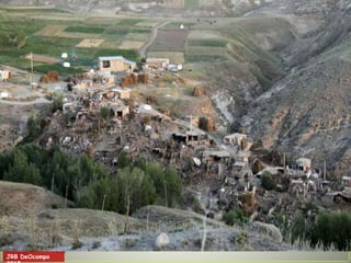
30. 17 AUG 1976 M7.9 MORO GULF
EARTHQUAKE AND TSUNAMI
• 12:11AM, Shallow depth (<33 km)
• First tsunami wave reported within 2 to
5 minutes of the main shock
• Series of waves (~3- 7 waves reported),
1-5 minutes apart
• Tsunami height up to 9 meters
• Maximum inundation inland – 2 km
• Death ~6000
• Injury ~8000
• Rendered homeless ~90,000
• Damage PhP400 million (1976 value)
Village inundated by tsunami
30
31. 1976 MORO GULF TSUNAMI
Observed Tsunami Heights
From Bautista et al 2006 - Reference: Badillo and Astilla, 1978
31
32. How do we prevent or
minimize the effects of these
natural hazards?
32
34. END TO END EARLY WARNING
HAZARDS AND RISK ASSESSMENT – potentially
affected areas, who and what will be affected
MONITORING - real time instrumentation if possible to
detect early; understand the processes
WARNING AND DISSEMINATION –forecasting and
communicating down to local residents the warning and
actions to take
PROPER RESPONSE
- Awareness, education
- Preparedness – evacuation sites and procedures; drills
- Planning for efficient and effective response
- standard operating procedures
- emergency operation plans
34
37. JRB DeOcampo
1. Ground Rupture
Creation of new or the renewed movements of old
fractures, oftentimes with the two blocks on both
sides moving in opposite directions.
Pilapils (rice paddy dikes) in Imugan,
Nueva Vizcaya displaced left-laterally
by the ground rupture of the 1990
Northern Luzon Earthquake.
37
42. JRB DeOcampo
Old Balakot before the earthquake
Photographed by Aamir Rashid
Old Balakot after the earthquake
Photographed by Takashi Nakata
2005 Kashmir, Pakistan Earthquake
42
43. JRB DeOcampo
43
a process where
particles of loosely
consolidated and
water-saturated
deposits are
rearranged into
more compact state,
squeezing water
and sediments
towards the surface
in the form of sand
fountain and
creating a condition
resembling “quick
sand”.
3. Liquefaction
52. JRB DeOcampo
2 TYPES OF TSUNAMI
Type Source Lead time
earthquake to
tsunami
Warning mechanism in
place
LOCAL trench or fault in
Philippine region,
usually less than
200 km from
shoreline
4 – 20
minutes
Being established
must rely on natural signs
such as moderate to intense
shaking in coastal area,
unusual water level rise or fall
FAR-FIELD
Regional
or Trans-
Pacific
trench or fault
outside the
Philippine
region
(ex. Japan,
Hawaii, Chile)
1 – 24
hours
International Centers*
PHIVOLCS
NDCC
*Pacific Tsunami Warning
Center, NW Pacific Tsunami
Information Center)
52
52
53. JRB DeOcampo Tsunami simulation of 1700 Cascadia Earthquake
Distant Tsunami
Local Tsunami
53
54. JRB DeOcampo
Photos by RUSolidum, PHIVOLCS
Kesennuma
Ogatsu
Movement of
heavy objects and
impact to
structures
Tsunami Damage and Effects
54
56. JRB DeOcampo
Forceful impact on houses, buildings, infrastructures
– erosion and destruction
Minami Sanriku, Miyagi, Japan
Photos by RUSolidum, PHIVOLCS)
Site of destroyed City Hall
Remnant of Disaster Prevention Building
Tsunami Damage and Effects
56
57. JRB DeOcampo
Miyako
Flooding of coastal areas
Drowning of people
Damage to properties
Natori
From AP
From Kyodo News
Rikuzentakata
PHIVOLCS
Tsunami Damage and Effects
57
58. JRB DeOcampo
More than 100 evacuation sites selected by the local
governments were inundated by tsunami
Rikuzentakata Gymnasium – outside, inside, clock
(Photos by RUSolidum, PHIVOLCS)
Tsunami Damage and Effects
58
59. JRB DeOcampo (Photos by RUSolidum, PHIVOLCS)
Clean up of inundated areas
Restoration of electric
power, communication and
water supply
Minamisanriku
Ogatsu
Iwaki
Provision of temporary housing
Japan (3months after the Tsunami)
59
61. JRB DeOcampo
61
Impacts of Indian Ocean Tsunami
Before
After
Impacts: erosion, flooding, destruction of houses, death
Banda Aceh, Sumatra, Indonesia
62. HAZARD AND IMPACT ASSESSMENT
SOFTWARE (REDAS* by DOST-PHIVOLCS)
• Hazard assessment module
- tools for assessing earthquake
hazards; preparing scenarios
- static maps of various hazards
(geological, hydro-meteorological)
can be integrated
• Exposure data base module
- contains database of elements at risk
which can be updated by local
government
• Impact assessment module
- can estimate damage to buildings,
casualty, economic loss
* being shared with local
governments, national
agencies, academic partners
63. GENERAL EARTHQUAKE
SCENARIOS
Offshore trenches
o may generate Magnitude 8.0+ earthquakes
o ground shaking intensities of PEIS VII –
VIII
Inland active fault systems
o may generate Magnitude 7.0+ earthquakes
o ground shaking intensities of PEIS VIII – IX
in areas within 10’s of Km from the active
fault.
67. PHILIPPINE TSUNAMI INFORMATION
Tsunami Information Threat to Philippines Recommended Action for
Affected Areas
Advisory
NO TSUNAMI
THREAT
Large earthquake
occurred but
no tsunami threat to
coastlines.
No evacuation needed. For
information only.
Advisory
SEA LEVEL CHANGE
MONITORING
Sea level change will
be monitored.
Public is advised to wait for
updates.
Advisory
MINOR SEA LEVEL
DISTURBANCE
Expected waves of less
than 1 meter above
expected ocean tide.
People advised to stay away
from beach.
People with houses very near
beach advised to move inland.
Boats at sea advised to stay
offshore in deep waters.
TSUNAMI WARNING Destructive tsunami
expected with wave
heights of more than 1
meter above ocean
tide.
Immediate evacuation of
coastal communities strongly
advised.
Boats at sea advised to stay
offshore in deep waters.
68. NATURAL SIGNS OF AN IMPENDING
LOCAL TSUNAMI
Felt earthquake
Unusual &
sudden rise or fall
of coastal waters
Exposure of corals,
underwater rocks,
and marine life
Unusual Sound
S H A K E
D R O P
R O A R
69. KEY MESSAGES
Region XII is prone to earthquakes, tsunamis and
volcanic eruptions.
Earthquakes are sudden onset events, can cause
wide-spread impacts.
Appropriate preparedness, mitigation and response
activities must be based on appropriate hazard and
impact scenarios.
Possible hazards and its effects in localities and the
whole region must be imagined to craft and
implement appropriate solutions.
Information and tools are available for communities
to be safer. Let us collectively make our communities
safer and resilient to disasters.