SlideShare a Scribd company logo
1 of 24
MODULE 5: FLOOD
MANAGEMENT
Floods are the most frequent type
of natural disaster and occur when
an overflow of water submerges
land that is usually dry. Floods are
often caused by heavy rainfall,
rapid snowmelt or a storm surge
from a tropical cyclone or tsunami
in coastal areas.
Floods can be dangerous. People
die by drowning when they don't
evacuate before floodwaters come
or when they enter floodwaters.
The maximum flood that any
structure can safely pass is called
the ‘design flood’ and is selected
after consideration of economic and
hydrologic factors
a. Indian Rivers and Floods
The rivers of India play an important role in the lives of the Indian people. The river
systems provide irrigation, potable water, cheap transportation, electricity, as well
as provide livelihoods for a large number of people all over the country.
This easily explains why nearly all the major cities of India are located by the banks
of river. The rivers also have an important role in Hindu mythology and are
considered holy by all Hindus in the country.
Seven major rivers (Indus, Brahmaputra, Narmada, Tapi, Godavari, Krishna and
Mahanadi )along with their numerous tributaries make up the river system of India.
Most of the rivers pour their waters into the Bay of Bengal. Some of the rivers
empty into the Arabian Sea. Parts of Ladakh, northern parts of the Aravalli range
and the arid parts of the Thar Desert have inland drainage.
All major rivers of India originate from one of the three main watersheds.
i The Himalaya and the Karakoram ranges
ii Vindhya and Satpura ranges and Chotanagpur plateau in central India
iii Sahyadri or Western Ghats in western India.
Himalayan Rivers : The main Himalayan river systems are the Ganga,
the Indus and the Brahmaputra river systems. The Himalayan rivers
form large basins. Many rivers pass through the Himalayas. These are
deep valleys with steep rock sides. They perform intense erosional
activity up the streams and carry huge load of sand and silt. In the
plains, they form large meanders.
These rivers are perennial as they get water from the rainfall as well as
the melting of ice. Nearly all of them create huge plains and are
navigable over long distances of their course. These rivers are also
harnessed in their upstream catchment area to generate
hydroelectricity
Peninsular Rivers : The main peninsular river systems include the Narmada, the Tapi, the Godavari,
the Krishna, the Kaveri and the Mahanadi river systems. The Peninsular rivers flow through shallow
valleys. A large number of them are seasonal as their flow is dependent on rainfall. The intensity of
erosional activities is also comparatively low because of the gentler slope. The hard rock bed and lack
of silt and sand does not allow any significant meandering. Many rivers therefore have straight and
linear courses. These rivers provide huge opportunities for hydro-electric power.
The Indus River System :
The Indus originates in the northern slopes of the Kailash range in Tibet near Lake Manasarovar. It
follows a north-westerly course through Tibet. It enters Indian territory in Jammu and Kashmir.
It forms a picturesque gorge in this part. Several tributaries - the Zaskar, the Shyok, the Nubra and the
Hunza join it in the Kashmir region. It flows through the regions of Ladakh, Baltistan and Gilgit and
runs between the Ladakh Range and the Zaskar Range. It crosses the Himalayas through a 5181 m
deep gorge near Attock, lying north of the Nanga Parbat and later takes a bend to the southwest
direction before entering Pakistan. It has a large number of tributaries in both India and Pakistan and
has a total length of about 2897 km from the source to the point near Karachi where it falls into the
Arabian Sea. The main tributaries of the Indus in India are Jhelum, Chenab, Ravi, Beas and Sutlej.
Sutlej
The Sutlej originates from the Rakas Lake, which is connected to the Manasarovar lake by
a stream, in Tibet. Its flows in a north-westerly direction and enters Himachal Pradesh at
the Shipki Pass, where it is joined by the Spiti river. It cuts deep gorges in the ranges of the
Himalayas, and finally enters the Punjab plain after cutting a gorge in a hill range, the
Naina Devi Dhar, where the Bhakra Dam having a large reservoir of water, called the
Gobind Sagar, has been constructed. It enters Pakistan near Suleimani and is later joined
by the Chenab. It has a total length of almost 1500 km.
The Brahmaputra River System
The Brahmaputra originates in the Mansarovar lake, It is slightly longer than the Indus,
but most of its course lies outside India. It flows eastward, parallel to the Himalayas.
Reaching Namcha Barwa (7757 m), it takes a U-turn around it and enters India in
Arunachal Pradesh and known as dihang. The undercutting done by this river is of the
order of 5500 metres. In India, it flows through Arunachal Pradesh and Assam, and is
joined by several tributaries.
In Tibet, the river is known as the Tsangpo. There, it receives less volume of water and has
less silt. But in India, it passes through a region of heavy rainfall and as such, the river
carries a large amount of rainfall and considerable amount of silt. The fury of the river
during rains is very high. It is known for creating havoc in Assam and Bangladesh.
The Narmada River System : The Narmada is a river in central India. It
forms the traditional boundary between North India and South India,
and is a total of 1,289 km long.. It rises on the summit of Amarkantak
Hill in Madhya Pradesh state, and for the first 320 kilometres (200
miles) of its course winds among the Mandla Hills, which form the head
of the Satpura Range; then at Jabalpur, passing through the 'Marble
Rocks', it enters the Narmada Valley between the Vindhya and Satpura
ranges, and pursues a direct westerly course to the Gulf of Cambay. Its
total length through the states of Madhya Pradesh, Maharashtra, and
Gujarat amounts to 1312 kilometres (815 miles), and it empties into the
Arabian Sea in the Bharuch district of Gujarat.
Ravi :The Ravi originates near the Rotang pass in the Kangra Himalayas
and follows a northwesterly course. It turns to the south-west, near
Dalhousie, and then cuts a gorge in the Dhaola Dhar range entering the
Punjab plain near Madhopur. It flows as a part of the Indo-Pakistan
border for some distance before entering Pakistan and joining the
Chenab river. The total length of the river is about 720 km.
The Godavari River System : The river with second longest course
within India. The river is about 1,450 km (900 miles) long. It rises at
Trimbakeshwar, near Nasik and Mumbai (formerly Bombay) in
Maharashtra around 380 km distance from the Arabian sea, but flows
southeast across south-central India through the states of Madhya
Pradesh, Karnataka, Orissa and Andhra Pradesh, and empties into the
Bay of Bengal. At Rajahmundry, 80 km from the coast, the river splits
into two streams thus forming a very fertile delta. Like any other major
rivers in India, the banks of this river also has many pilgrimage sites,
Nasik, Triyambak and Bhadrachalam, being the major ones.
It is a seasonal river, widened during the monsoons and dried during
the summers. Godavari river water is brownish. Some important urban
centers on its banks include Nasik, Bhadrachalam, Rajahmundry and
Narsapur. The Asia's largest rail-cum-road bridge on the river Godavari
linking Kovvur and Rajahmundry is considered to be an engineering
feat.
The Krishna River System : The Krishna is one of the
longest rivers of India (about 1300 km in length). It
originates at Mahabaleswar in Maharashtra, passes
through Sangli and meets the sea in the Bay of
Bengal at Hamasaladeevi in Andhra Pradesh. The
Krishna River flows through the states of
Maharashtra, Karnataka and Andhra Pradesh.
Its most important tributary is the Tungabhadra
River, which itself is formed by the Tunga and Bhadra
rivers that originate in the Western Ghats. Other
tributaries include the Koyna, Bhima, Mallaprabha,
Ghataprabha, Yerla, Warna, Dindi, Musi and
Dudhganga rivers.
The Kaveri River System : The Kaveri (also spelled Cauvery or Kavery) is one
of the great rivers of India and is considered sacred by the Hindus. This river
is also called Dakshin Ganga. The headwaters are in the Western Ghats range
of Karnataka state, and from Karnataka through Tamil Nadu. It empties into
the Bay of Bengal. Its waters have supported irrigated agriculture for
centuries, and the Kaveri has been the lifeblood of the ancient kingdoms and
modern cities of South India.
The source of the river is Talakaveri located in the Western Ghats about
5,000 feet (1,500 m) above sea level. Talakaveri is a famous pligrimage and
tourist spot set amidst Bramahagiri Hills near Madikeri in Kodagu district of
Karnataka. Thousands of piligrims flock to the temple at the source of the
river especially on the specified day known as Tula sankramana when the
river water has been witnessed to gush out like a fountain at a
predetermined time. It flows generally south and east for around 765 km,
emptying into the Bay of Bengal through two principal mouths. Its basin is
estimated to be 27,700 square miles (71,700 km²), and it has many
tributaries including Shimsha, Hemavati, Arkavathy, Kapila, Honnuhole,
Lakshmana Tirtha, Kabini, Lokapavani, Bhavani, Noyyal and Famous
Amaravati
CAUSES OF FLOODS:
1.Meteorological factors
2.Physical factors
3.Human factors
1.Meteorological factors :
Heavy Rainfall: During the monsoon season, rainwater
flows and is collected in dams. When this collected
water reaches beyond the storage capacity limit, it ends
up in flood.
Cloud Burst: Cloud Burst occurs due to intense
precipitation in a short duration which may be
accompanied by hail and storm and can cause a flood.
These natural incidents occur at the mountain slopes,
and water runs down towards the plains, causing a
flood.
• Cyclone: Cyclones occur in a low-pressure zone where winds
rotate inwardly. Cyclones can be accompanied by a massive
storm and lead to extreme weather conditions. Four eastern
coastal states in India, such as Tamil Nadu, West Bengal, Odisha,
Andhra Pradesh, mostly suffer from cyclonic floods.
• Global Warming: Due to the increased rise in global
temperature, glaciers of the Himalayan range start to melt. As a
result, the seawater level also rises, causing floods in
surrounding years.
• Earthquakes and Landslides: A shift in tectonic plates can lead
to alteration in the volume and course of surface water
resulting in flood hazard. During landslides, the flow of debris
into the water surface increases the level of river sediment
causing floods.
2. Physical Factors
• Insufficient Drainage Management:
Improper planning of the drainage
system of an area can cause excess
water due to heavy rainfall to get stuck
and lead to a flood.
• Catchment Area: Catchment area is an
area from where the rainfall water flows
into a river. This can be a lake or
reservoir. During monsoon, when
excess water exceeds the limit of
holding capacity of the catchment area,
3. Human Factor
Siltation: Siltation refers to the flow of silt and sediments in the
riverbed. As particles remain suspended in the river and
accumulated in the riverbed, it disrupts the flow of the river,
causing a flood.
Improper Agricultural Practices: If farmers are not cautious of the
effects of farming practices meaning if they leave the waste
material into the river or cannot handle water management
properly, it can lead to a flood.
Deforestation: Trees act like a sponge that helps to hold soil and
water and prevent flooding. As trees are being cut down at a fast
pace to make way for urbanization to grow, more water runs
towards a river during heavy rainfall. As a result, a flood occurs.
Collapse of Dams: As dams are human-made, these can be worn
out and subsequently collapse causing floods. Also, if heavy
rainfall sustains for a long time, State Governments often declare
to open dam gates which can lead to a dangerous flood.
Types of floods
i Coastal Floods: Coastal floods occur when strong winds or
storms move towards the coast during high tide.
ii Flash Floods: Flash floods usually occur in hilly areas in limited
space. Here the sudden heavy rainfall or snow thaws are the
causes of flooding. The fast-moving torrent of Flash floods can
sweep large objects such as cars, rocks and everything that
comes in their path.
iii River Floods: River floods occur due to the inflow of water
from heavy rainfall, snowmelt or powerful storms.
iv Pluvial Floods: Pluvial floods occur in areas that cannot hold
rainwater and end up forming puddles and ponds. These types
of floods are the event of rural areas.
v Urban Floods: When the drainage system of urban areas fails
to absorb rainwater, it creates urban floods.
vi Groundwater Floods: Incessant rainfall can increase the water
level present in soil underground making it saturated. Significant
rise in water level above the ground’s surface leads to flooding.
Effects of Flood
The consequences of flood depend on the location, duration, and vulnerability of the
area. The impacts of floods affect both individuals and communities and have social-
environmental consequences. Below is a list of damage caused by floods.
a.Human Loss and Property Loss: Every year, millions of people become homeless
and washed away due to floods.
b.Spread of Communicable Diseases: Waterborne diseases like cholera, typhoid fever,
hepatitis, and leptospirosis spread in flood-affected areas. Floods also lead to
vectorborne diseases, transmitted through parasites and pathogens such as a
mosquito. As a result, the health of flood victims deteriorates.
c.Destruction of Crops: Every year, floods destroy a large number of crops.
d.Loss of Livestock: Like humans, livestock also get displaced during floods and die
due to the loss of their habitats.
e. Disruption of Communication Link and Transportation: Flood causes damage to
transportation links such as bridges, rail, power plants etc., thus causing
communication disruption in those areas.
f.Economic and Social Disruption: The economy comes to a standstill as people are
forced to move to another place, and revival of this situation takes time.
List of flood-prone zones or areas in India.
Punjab
Haryana
North Bihar
West Bengal
Uttar Pradesh
Coastal Andhra Pradesh
Odisha
Southern Gujarat
Brahmaputra Valley
Ganga River Basin
North-west region of River Narmada and Tapti
Deccan region near River Mahanadi, Krishna and
Kaveri.
FLOOD ALLEVIATION
ALLEVIATION means Flood control or flood mitigation, or flood protection methods
used to reduce or prevent the detrimental effects of flood waters.
Flood alleviation schemes involves the construction of flood walls, banks, levees
and other flood management measures to reduce flood risk to homes and
commercial property which have been identified as being at significant risk.
LEVEE
A levee/ dyke/ embankment/ floodbank, or a stop bank is a structure used to keep
the course of rivers from changing and to protect against flooding of the area
adjoining the river or coast. It is usually earthen structure and often runs parallel to
the course of a river in its floodplain or along low-lying coastlines.
Levees can be naturally occurring ridge structures that form next to the bank of a
river or be an artificially constructed fill or wall that regulates water levels.
However, levees can be bad for the environment. Floodwalls are a more confined
alternative.
Today, levees can be found around the world, and failures of levees due to erosion
or other causes can be major disasters, such as the catastrophic 2005 levee failures
in Greater New Orleans that occurred as a result of Hurricane Katrina.
The side of a levee in
Sacramento, California
Uses/ applications of levees
The main purpose of artificial levees is to prevent
flooding of the adjoining countryside and to slow
natural course changes in a waterway to provide
reliable shipping lanes for goods shipment over
time;
They also confine the flow of the river, resulting in
higher and faster water flow. Furthermore, levees
have been built as a boundary for an inundation
area.
Levees have also been built as field boundaries
and as military defenses.
Levees are usually built by piling earth on a cleared, level surface. Broad
at the base, they taper to a level top, where temporary embankments
or sandbags can be placed. Because flood discharge intensity increases
in levees on both riverbanks, and because silt deposits raise the level of
riverbeds, planning and auxiliary measures are vital. A levee made from
stones laid in horizontal rows with a bed of thin turf between each of
them is known as a spetchel.
Artificial levees require substantial engineering. Their surface must be
protected from erosion, so they are planted with vegetation such as
Bermuda grass in order to bind the earth together. On the land side of
high levees, a low terrace of earth known as a banquette is usually
added as another anti-erosion measure. On the river side, erosion from
strong waves or currents presents an even greater threat to the
integrity of the levee. The effects of erosion are countered by planting
suitable vegetation or installing stones, boulders, weighted matting, or
concrete revetments. Separate ditches or drainage tiles are constructed
to ensure that the foundation does not become waterlogged.
FLOODWALLS :
A floodwall is a freestanding,
permanent, engineered structure
designed to prevent encroachment
of floodwaters. Floodwalls are
mainly used on locations where
space is scarce, such as cities or
where building levees or dykes
would interfere with existing
buildings, historical architecture or
commercial use of embankments.
Floodwalls are nowadays mainly
constructed from pre-fabricated
concrete elements. Floodwalls often
have floodgates which are large
openings to provide passage except
during periods of flooding, when
they are closed.
Flood Ways: A floodway is a flood plain crossing for a road,
built at or close to the natural ground level. It is similar to a
causeway, but crosses a shallow depression that is subject to
flooding, rather than a waterway or tidal water.
They are designed to be submerged under water. Typically
floodways are used when the flood frequency or time span is
minimal, traffic volumes are low, and the cost of a bridge is
uneconomical – in most cases, in rural areas.
Channel improvement: An engineering scheme that is
designed to stabilize a river channel to increase flow speeds,
reduce bank erosion, and/or protect against flooding. This
might involve decreasing channel roughness (for example by
lining the channel with smooth artificial bed and banks),
widening and/or deepening the channel (by dredging), or
shortening the channel (by straightening it and cutting off
meander bends). Also known as channelization.
Flood damage analysis:
Flood damage is defined as all the varieties of harm
provoked by flooding. It includes all detrimental
effects on people, their health, and properties; on
public and private infrastructure, ecological
systems, cultural heritage, and economic activities.
Understanding the nature of flood damage is
important in assessing flood risk. For most people,
the benefits of flood risk reduction at the coast is
the direct flood damage on property and economic
activity avoided as a result of schemes to reduce
either the frequency or impact of flooding.

More Related Content

Similar to Floods and it's Management, Effects of Floods

Similar to Floods and it's Management, Effects of Floods (20)

Drainage
Drainage Drainage
Drainage
 
drainage
drainagedrainage
drainage
 
Peninsularrivers 130805105647-phpapp01 (1)-converted (1)
Peninsularrivers 130805105647-phpapp01 (1)-converted (1)Peninsularrivers 130805105647-phpapp01 (1)-converted (1)
Peninsularrivers 130805105647-phpapp01 (1)-converted (1)
 
Drainange
DrainangeDrainange
Drainange
 
Drainage part 1
Drainage part 1Drainage part 1
Drainage part 1
 
PPT on India's Drainage System (River System)
PPT on India's Drainage System (River System) PPT on India's Drainage System (River System)
PPT on India's Drainage System (River System)
 
Drainage
DrainageDrainage
Drainage
 
Drainages
DrainagesDrainages
Drainages
 
Indian rivers
Indian riversIndian rivers
Indian rivers
 
Drainage
DrainageDrainage
Drainage
 
Drainage.pdf
Drainage.pdfDrainage.pdf
Drainage.pdf
 
Drainage
DrainageDrainage
Drainage
 
Drainage
DrainageDrainage
Drainage
 
Drainage
DrainageDrainage
Drainage
 
himalayan rivers
himalayan rivershimalayan rivers
himalayan rivers
 
Peninsular rivers
Peninsular riversPeninsular rivers
Peninsular rivers
 
1258766 634577170996418750
1258766 6345771709964187501258766 634577170996418750
1258766 634577170996418750
 
Drainage
DrainageDrainage
Drainage
 
Sst drainage by Anshuman
Sst drainage by AnshumanSst drainage by Anshuman
Sst drainage by Anshuman
 
Drainage
DrainageDrainage
Drainage
 

Recently uploaded

Introduction to AI in Higher Education_draft.pptx
Introduction to AI in Higher Education_draft.pptxIntroduction to AI in Higher Education_draft.pptx
Introduction to AI in Higher Education_draft.pptxpboyjonauth
 
Presiding Officer Training module 2024 lok sabha elections
Presiding Officer Training module 2024 lok sabha electionsPresiding Officer Training module 2024 lok sabha elections
Presiding Officer Training module 2024 lok sabha electionsanshu789521
 
Full Stack Web Development Course for Beginners
Full Stack Web Development Course  for BeginnersFull Stack Web Development Course  for Beginners
Full Stack Web Development Course for BeginnersSabitha Banu
 
Computed Fields and api Depends in the Odoo 17
Computed Fields and api Depends in the Odoo 17Computed Fields and api Depends in the Odoo 17
Computed Fields and api Depends in the Odoo 17Celine George
 
Types of Journalistic Writing Grade 8.pptx
Types of Journalistic Writing Grade 8.pptxTypes of Journalistic Writing Grade 8.pptx
Types of Journalistic Writing Grade 8.pptxEyham Joco
 
Introduction to ArtificiaI Intelligence in Higher Education
Introduction to ArtificiaI Intelligence in Higher EducationIntroduction to ArtificiaI Intelligence in Higher Education
Introduction to ArtificiaI Intelligence in Higher Educationpboyjonauth
 
Interactive Powerpoint_How to Master effective communication
Interactive Powerpoint_How to Master effective communicationInteractive Powerpoint_How to Master effective communication
Interactive Powerpoint_How to Master effective communicationnomboosow
 
Organic Name Reactions for the students and aspirants of Chemistry12th.pptx
Organic Name Reactions  for the students and aspirants of Chemistry12th.pptxOrganic Name Reactions  for the students and aspirants of Chemistry12th.pptx
Organic Name Reactions for the students and aspirants of Chemistry12th.pptxVS Mahajan Coaching Centre
 
Enzyme, Pharmaceutical Aids, Miscellaneous Last Part of Chapter no 5th.pdf
Enzyme, Pharmaceutical Aids, Miscellaneous Last Part of Chapter no 5th.pdfEnzyme, Pharmaceutical Aids, Miscellaneous Last Part of Chapter no 5th.pdf
Enzyme, Pharmaceutical Aids, Miscellaneous Last Part of Chapter no 5th.pdfSumit Tiwari
 
EPANDING THE CONTENT OF AN OUTLINE using notes.pptx
EPANDING THE CONTENT OF AN OUTLINE using notes.pptxEPANDING THE CONTENT OF AN OUTLINE using notes.pptx
EPANDING THE CONTENT OF AN OUTLINE using notes.pptxRaymartEstabillo3
 
Roles & Responsibilities in Pharmacovigilance
Roles & Responsibilities in PharmacovigilanceRoles & Responsibilities in Pharmacovigilance
Roles & Responsibilities in PharmacovigilanceSamikshaHamane
 
POINT- BIOCHEMISTRY SEM 2 ENZYMES UNIT 5.pptx
POINT- BIOCHEMISTRY SEM 2 ENZYMES UNIT 5.pptxPOINT- BIOCHEMISTRY SEM 2 ENZYMES UNIT 5.pptx
POINT- BIOCHEMISTRY SEM 2 ENZYMES UNIT 5.pptxSayali Powar
 
भारत-रोम व्यापार.pptx, Indo-Roman Trade,
भारत-रोम व्यापार.pptx, Indo-Roman Trade,भारत-रोम व्यापार.pptx, Indo-Roman Trade,
भारत-रोम व्यापार.pptx, Indo-Roman Trade,Virag Sontakke
 
How to Configure Email Server in Odoo 17
How to Configure Email Server in Odoo 17How to Configure Email Server in Odoo 17
How to Configure Email Server in Odoo 17Celine George
 
Biting mechanism of poisonous snakes.pdf
Biting mechanism of poisonous snakes.pdfBiting mechanism of poisonous snakes.pdf
Biting mechanism of poisonous snakes.pdfadityarao40181
 
DATA STRUCTURE AND ALGORITHM for beginners
DATA STRUCTURE AND ALGORITHM for beginnersDATA STRUCTURE AND ALGORITHM for beginners
DATA STRUCTURE AND ALGORITHM for beginnersSabitha Banu
 

Recently uploaded (20)

ESSENTIAL of (CS/IT/IS) class 06 (database)
ESSENTIAL of (CS/IT/IS) class 06 (database)ESSENTIAL of (CS/IT/IS) class 06 (database)
ESSENTIAL of (CS/IT/IS) class 06 (database)
 
Introduction to AI in Higher Education_draft.pptx
Introduction to AI in Higher Education_draft.pptxIntroduction to AI in Higher Education_draft.pptx
Introduction to AI in Higher Education_draft.pptx
 
Presiding Officer Training module 2024 lok sabha elections
Presiding Officer Training module 2024 lok sabha electionsPresiding Officer Training module 2024 lok sabha elections
Presiding Officer Training module 2024 lok sabha elections
 
Full Stack Web Development Course for Beginners
Full Stack Web Development Course  for BeginnersFull Stack Web Development Course  for Beginners
Full Stack Web Development Course for Beginners
 
Computed Fields and api Depends in the Odoo 17
Computed Fields and api Depends in the Odoo 17Computed Fields and api Depends in the Odoo 17
Computed Fields and api Depends in the Odoo 17
 
9953330565 Low Rate Call Girls In Rohini Delhi NCR
9953330565 Low Rate Call Girls In Rohini  Delhi NCR9953330565 Low Rate Call Girls In Rohini  Delhi NCR
9953330565 Low Rate Call Girls In Rohini Delhi NCR
 
Model Call Girl in Bikash Puri Delhi reach out to us at 🔝9953056974🔝
Model Call Girl in Bikash Puri  Delhi reach out to us at 🔝9953056974🔝Model Call Girl in Bikash Puri  Delhi reach out to us at 🔝9953056974🔝
Model Call Girl in Bikash Puri Delhi reach out to us at 🔝9953056974🔝
 
Types of Journalistic Writing Grade 8.pptx
Types of Journalistic Writing Grade 8.pptxTypes of Journalistic Writing Grade 8.pptx
Types of Journalistic Writing Grade 8.pptx
 
Introduction to ArtificiaI Intelligence in Higher Education
Introduction to ArtificiaI Intelligence in Higher EducationIntroduction to ArtificiaI Intelligence in Higher Education
Introduction to ArtificiaI Intelligence in Higher Education
 
Interactive Powerpoint_How to Master effective communication
Interactive Powerpoint_How to Master effective communicationInteractive Powerpoint_How to Master effective communication
Interactive Powerpoint_How to Master effective communication
 
TataKelola dan KamSiber Kecerdasan Buatan v022.pdf
TataKelola dan KamSiber Kecerdasan Buatan v022.pdfTataKelola dan KamSiber Kecerdasan Buatan v022.pdf
TataKelola dan KamSiber Kecerdasan Buatan v022.pdf
 
Organic Name Reactions for the students and aspirants of Chemistry12th.pptx
Organic Name Reactions  for the students and aspirants of Chemistry12th.pptxOrganic Name Reactions  for the students and aspirants of Chemistry12th.pptx
Organic Name Reactions for the students and aspirants of Chemistry12th.pptx
 
Enzyme, Pharmaceutical Aids, Miscellaneous Last Part of Chapter no 5th.pdf
Enzyme, Pharmaceutical Aids, Miscellaneous Last Part of Chapter no 5th.pdfEnzyme, Pharmaceutical Aids, Miscellaneous Last Part of Chapter no 5th.pdf
Enzyme, Pharmaceutical Aids, Miscellaneous Last Part of Chapter no 5th.pdf
 
EPANDING THE CONTENT OF AN OUTLINE using notes.pptx
EPANDING THE CONTENT OF AN OUTLINE using notes.pptxEPANDING THE CONTENT OF AN OUTLINE using notes.pptx
EPANDING THE CONTENT OF AN OUTLINE using notes.pptx
 
Roles & Responsibilities in Pharmacovigilance
Roles & Responsibilities in PharmacovigilanceRoles & Responsibilities in Pharmacovigilance
Roles & Responsibilities in Pharmacovigilance
 
POINT- BIOCHEMISTRY SEM 2 ENZYMES UNIT 5.pptx
POINT- BIOCHEMISTRY SEM 2 ENZYMES UNIT 5.pptxPOINT- BIOCHEMISTRY SEM 2 ENZYMES UNIT 5.pptx
POINT- BIOCHEMISTRY SEM 2 ENZYMES UNIT 5.pptx
 
भारत-रोम व्यापार.pptx, Indo-Roman Trade,
भारत-रोम व्यापार.pptx, Indo-Roman Trade,भारत-रोम व्यापार.pptx, Indo-Roman Trade,
भारत-रोम व्यापार.pptx, Indo-Roman Trade,
 
How to Configure Email Server in Odoo 17
How to Configure Email Server in Odoo 17How to Configure Email Server in Odoo 17
How to Configure Email Server in Odoo 17
 
Biting mechanism of poisonous snakes.pdf
Biting mechanism of poisonous snakes.pdfBiting mechanism of poisonous snakes.pdf
Biting mechanism of poisonous snakes.pdf
 
DATA STRUCTURE AND ALGORITHM for beginners
DATA STRUCTURE AND ALGORITHM for beginnersDATA STRUCTURE AND ALGORITHM for beginners
DATA STRUCTURE AND ALGORITHM for beginners
 

Floods and it's Management, Effects of Floods

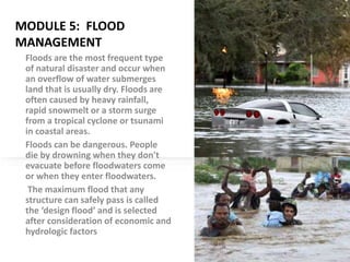
  • 1. MODULE 5: FLOOD MANAGEMENT Floods are the most frequent type of natural disaster and occur when an overflow of water submerges land that is usually dry. Floods are often caused by heavy rainfall, rapid snowmelt or a storm surge from a tropical cyclone or tsunami in coastal areas. Floods can be dangerous. People die by drowning when they don't evacuate before floodwaters come or when they enter floodwaters. The maximum flood that any structure can safely pass is called the ‘design flood’ and is selected after consideration of economic and hydrologic factors
  • 2. a. Indian Rivers and Floods The rivers of India play an important role in the lives of the Indian people. The river systems provide irrigation, potable water, cheap transportation, electricity, as well as provide livelihoods for a large number of people all over the country. This easily explains why nearly all the major cities of India are located by the banks of river. The rivers also have an important role in Hindu mythology and are considered holy by all Hindus in the country. Seven major rivers (Indus, Brahmaputra, Narmada, Tapi, Godavari, Krishna and Mahanadi )along with their numerous tributaries make up the river system of India. Most of the rivers pour their waters into the Bay of Bengal. Some of the rivers empty into the Arabian Sea. Parts of Ladakh, northern parts of the Aravalli range and the arid parts of the Thar Desert have inland drainage.
  • 3. All major rivers of India originate from one of the three main watersheds. i The Himalaya and the Karakoram ranges ii Vindhya and Satpura ranges and Chotanagpur plateau in central India iii Sahyadri or Western Ghats in western India. Himalayan Rivers : The main Himalayan river systems are the Ganga, the Indus and the Brahmaputra river systems. The Himalayan rivers form large basins. Many rivers pass through the Himalayas. These are deep valleys with steep rock sides. They perform intense erosional activity up the streams and carry huge load of sand and silt. In the plains, they form large meanders. These rivers are perennial as they get water from the rainfall as well as the melting of ice. Nearly all of them create huge plains and are navigable over long distances of their course. These rivers are also harnessed in their upstream catchment area to generate hydroelectricity
  • 4. Peninsular Rivers : The main peninsular river systems include the Narmada, the Tapi, the Godavari, the Krishna, the Kaveri and the Mahanadi river systems. The Peninsular rivers flow through shallow valleys. A large number of them are seasonal as their flow is dependent on rainfall. The intensity of erosional activities is also comparatively low because of the gentler slope. The hard rock bed and lack of silt and sand does not allow any significant meandering. Many rivers therefore have straight and linear courses. These rivers provide huge opportunities for hydro-electric power. The Indus River System : The Indus originates in the northern slopes of the Kailash range in Tibet near Lake Manasarovar. It follows a north-westerly course through Tibet. It enters Indian territory in Jammu and Kashmir. It forms a picturesque gorge in this part. Several tributaries - the Zaskar, the Shyok, the Nubra and the Hunza join it in the Kashmir region. It flows through the regions of Ladakh, Baltistan and Gilgit and runs between the Ladakh Range and the Zaskar Range. It crosses the Himalayas through a 5181 m deep gorge near Attock, lying north of the Nanga Parbat and later takes a bend to the southwest direction before entering Pakistan. It has a large number of tributaries in both India and Pakistan and has a total length of about 2897 km from the source to the point near Karachi where it falls into the Arabian Sea. The main tributaries of the Indus in India are Jhelum, Chenab, Ravi, Beas and Sutlej.
  • 5. Sutlej The Sutlej originates from the Rakas Lake, which is connected to the Manasarovar lake by a stream, in Tibet. Its flows in a north-westerly direction and enters Himachal Pradesh at the Shipki Pass, where it is joined by the Spiti river. It cuts deep gorges in the ranges of the Himalayas, and finally enters the Punjab plain after cutting a gorge in a hill range, the Naina Devi Dhar, where the Bhakra Dam having a large reservoir of water, called the Gobind Sagar, has been constructed. It enters Pakistan near Suleimani and is later joined by the Chenab. It has a total length of almost 1500 km. The Brahmaputra River System The Brahmaputra originates in the Mansarovar lake, It is slightly longer than the Indus, but most of its course lies outside India. It flows eastward, parallel to the Himalayas. Reaching Namcha Barwa (7757 m), it takes a U-turn around it and enters India in Arunachal Pradesh and known as dihang. The undercutting done by this river is of the order of 5500 metres. In India, it flows through Arunachal Pradesh and Assam, and is joined by several tributaries. In Tibet, the river is known as the Tsangpo. There, it receives less volume of water and has less silt. But in India, it passes through a region of heavy rainfall and as such, the river carries a large amount of rainfall and considerable amount of silt. The fury of the river during rains is very high. It is known for creating havoc in Assam and Bangladesh.
  • 6. The Narmada River System : The Narmada is a river in central India. It forms the traditional boundary between North India and South India, and is a total of 1,289 km long.. It rises on the summit of Amarkantak Hill in Madhya Pradesh state, and for the first 320 kilometres (200 miles) of its course winds among the Mandla Hills, which form the head of the Satpura Range; then at Jabalpur, passing through the 'Marble Rocks', it enters the Narmada Valley between the Vindhya and Satpura ranges, and pursues a direct westerly course to the Gulf of Cambay. Its total length through the states of Madhya Pradesh, Maharashtra, and Gujarat amounts to 1312 kilometres (815 miles), and it empties into the Arabian Sea in the Bharuch district of Gujarat. Ravi :The Ravi originates near the Rotang pass in the Kangra Himalayas and follows a northwesterly course. It turns to the south-west, near Dalhousie, and then cuts a gorge in the Dhaola Dhar range entering the Punjab plain near Madhopur. It flows as a part of the Indo-Pakistan border for some distance before entering Pakistan and joining the Chenab river. The total length of the river is about 720 km.
  • 7. The Godavari River System : The river with second longest course within India. The river is about 1,450 km (900 miles) long. It rises at Trimbakeshwar, near Nasik and Mumbai (formerly Bombay) in Maharashtra around 380 km distance from the Arabian sea, but flows southeast across south-central India through the states of Madhya Pradesh, Karnataka, Orissa and Andhra Pradesh, and empties into the Bay of Bengal. At Rajahmundry, 80 km from the coast, the river splits into two streams thus forming a very fertile delta. Like any other major rivers in India, the banks of this river also has many pilgrimage sites, Nasik, Triyambak and Bhadrachalam, being the major ones. It is a seasonal river, widened during the monsoons and dried during the summers. Godavari river water is brownish. Some important urban centers on its banks include Nasik, Bhadrachalam, Rajahmundry and Narsapur. The Asia's largest rail-cum-road bridge on the river Godavari linking Kovvur and Rajahmundry is considered to be an engineering feat.
  • 8. The Krishna River System : The Krishna is one of the longest rivers of India (about 1300 km in length). It originates at Mahabaleswar in Maharashtra, passes through Sangli and meets the sea in the Bay of Bengal at Hamasaladeevi in Andhra Pradesh. The Krishna River flows through the states of Maharashtra, Karnataka and Andhra Pradesh. Its most important tributary is the Tungabhadra River, which itself is formed by the Tunga and Bhadra rivers that originate in the Western Ghats. Other tributaries include the Koyna, Bhima, Mallaprabha, Ghataprabha, Yerla, Warna, Dindi, Musi and Dudhganga rivers.
  • 9. The Kaveri River System : The Kaveri (also spelled Cauvery or Kavery) is one of the great rivers of India and is considered sacred by the Hindus. This river is also called Dakshin Ganga. The headwaters are in the Western Ghats range of Karnataka state, and from Karnataka through Tamil Nadu. It empties into the Bay of Bengal. Its waters have supported irrigated agriculture for centuries, and the Kaveri has been the lifeblood of the ancient kingdoms and modern cities of South India. The source of the river is Talakaveri located in the Western Ghats about 5,000 feet (1,500 m) above sea level. Talakaveri is a famous pligrimage and tourist spot set amidst Bramahagiri Hills near Madikeri in Kodagu district of Karnataka. Thousands of piligrims flock to the temple at the source of the river especially on the specified day known as Tula sankramana when the river water has been witnessed to gush out like a fountain at a predetermined time. It flows generally south and east for around 765 km, emptying into the Bay of Bengal through two principal mouths. Its basin is estimated to be 27,700 square miles (71,700 km²), and it has many tributaries including Shimsha, Hemavati, Arkavathy, Kapila, Honnuhole, Lakshmana Tirtha, Kabini, Lokapavani, Bhavani, Noyyal and Famous Amaravati
  • 10. CAUSES OF FLOODS: 1.Meteorological factors 2.Physical factors 3.Human factors 1.Meteorological factors : Heavy Rainfall: During the monsoon season, rainwater flows and is collected in dams. When this collected water reaches beyond the storage capacity limit, it ends up in flood. Cloud Burst: Cloud Burst occurs due to intense precipitation in a short duration which may be accompanied by hail and storm and can cause a flood. These natural incidents occur at the mountain slopes, and water runs down towards the plains, causing a flood.
  • 11. • Cyclone: Cyclones occur in a low-pressure zone where winds rotate inwardly. Cyclones can be accompanied by a massive storm and lead to extreme weather conditions. Four eastern coastal states in India, such as Tamil Nadu, West Bengal, Odisha, Andhra Pradesh, mostly suffer from cyclonic floods. • Global Warming: Due to the increased rise in global temperature, glaciers of the Himalayan range start to melt. As a result, the seawater level also rises, causing floods in surrounding years. • Earthquakes and Landslides: A shift in tectonic plates can lead to alteration in the volume and course of surface water resulting in flood hazard. During landslides, the flow of debris into the water surface increases the level of river sediment causing floods.
  • 12. 2. Physical Factors • Insufficient Drainage Management: Improper planning of the drainage system of an area can cause excess water due to heavy rainfall to get stuck and lead to a flood. • Catchment Area: Catchment area is an area from where the rainfall water flows into a river. This can be a lake or reservoir. During monsoon, when excess water exceeds the limit of holding capacity of the catchment area,
  • 13. 3. Human Factor Siltation: Siltation refers to the flow of silt and sediments in the riverbed. As particles remain suspended in the river and accumulated in the riverbed, it disrupts the flow of the river, causing a flood. Improper Agricultural Practices: If farmers are not cautious of the effects of farming practices meaning if they leave the waste material into the river or cannot handle water management properly, it can lead to a flood. Deforestation: Trees act like a sponge that helps to hold soil and water and prevent flooding. As trees are being cut down at a fast pace to make way for urbanization to grow, more water runs towards a river during heavy rainfall. As a result, a flood occurs. Collapse of Dams: As dams are human-made, these can be worn out and subsequently collapse causing floods. Also, if heavy rainfall sustains for a long time, State Governments often declare to open dam gates which can lead to a dangerous flood.
  • 14. Types of floods i Coastal Floods: Coastal floods occur when strong winds or storms move towards the coast during high tide. ii Flash Floods: Flash floods usually occur in hilly areas in limited space. Here the sudden heavy rainfall or snow thaws are the causes of flooding. The fast-moving torrent of Flash floods can sweep large objects such as cars, rocks and everything that comes in their path. iii River Floods: River floods occur due to the inflow of water from heavy rainfall, snowmelt or powerful storms. iv Pluvial Floods: Pluvial floods occur in areas that cannot hold rainwater and end up forming puddles and ponds. These types of floods are the event of rural areas. v Urban Floods: When the drainage system of urban areas fails to absorb rainwater, it creates urban floods. vi Groundwater Floods: Incessant rainfall can increase the water level present in soil underground making it saturated. Significant rise in water level above the ground’s surface leads to flooding.
  • 15. Effects of Flood The consequences of flood depend on the location, duration, and vulnerability of the area. The impacts of floods affect both individuals and communities and have social- environmental consequences. Below is a list of damage caused by floods. a.Human Loss and Property Loss: Every year, millions of people become homeless and washed away due to floods. b.Spread of Communicable Diseases: Waterborne diseases like cholera, typhoid fever, hepatitis, and leptospirosis spread in flood-affected areas. Floods also lead to vectorborne diseases, transmitted through parasites and pathogens such as a mosquito. As a result, the health of flood victims deteriorates. c.Destruction of Crops: Every year, floods destroy a large number of crops. d.Loss of Livestock: Like humans, livestock also get displaced during floods and die due to the loss of their habitats. e. Disruption of Communication Link and Transportation: Flood causes damage to transportation links such as bridges, rail, power plants etc., thus causing communication disruption in those areas. f.Economic and Social Disruption: The economy comes to a standstill as people are forced to move to another place, and revival of this situation takes time.
  • 16. List of flood-prone zones or areas in India. Punjab Haryana North Bihar West Bengal Uttar Pradesh Coastal Andhra Pradesh Odisha Southern Gujarat Brahmaputra Valley Ganga River Basin North-west region of River Narmada and Tapti Deccan region near River Mahanadi, Krishna and Kaveri.
  • 17. FLOOD ALLEVIATION ALLEVIATION means Flood control or flood mitigation, or flood protection methods used to reduce or prevent the detrimental effects of flood waters. Flood alleviation schemes involves the construction of flood walls, banks, levees and other flood management measures to reduce flood risk to homes and commercial property which have been identified as being at significant risk. LEVEE A levee/ dyke/ embankment/ floodbank, or a stop bank is a structure used to keep the course of rivers from changing and to protect against flooding of the area adjoining the river or coast. It is usually earthen structure and often runs parallel to the course of a river in its floodplain or along low-lying coastlines. Levees can be naturally occurring ridge structures that form next to the bank of a river or be an artificially constructed fill or wall that regulates water levels. However, levees can be bad for the environment. Floodwalls are a more confined alternative. Today, levees can be found around the world, and failures of levees due to erosion or other causes can be major disasters, such as the catastrophic 2005 levee failures in Greater New Orleans that occurred as a result of Hurricane Katrina.
  • 18.
  • 19. The side of a levee in Sacramento, California
  • 20. Uses/ applications of levees The main purpose of artificial levees is to prevent flooding of the adjoining countryside and to slow natural course changes in a waterway to provide reliable shipping lanes for goods shipment over time; They also confine the flow of the river, resulting in higher and faster water flow. Furthermore, levees have been built as a boundary for an inundation area. Levees have also been built as field boundaries and as military defenses.
  • 21. Levees are usually built by piling earth on a cleared, level surface. Broad at the base, they taper to a level top, where temporary embankments or sandbags can be placed. Because flood discharge intensity increases in levees on both riverbanks, and because silt deposits raise the level of riverbeds, planning and auxiliary measures are vital. A levee made from stones laid in horizontal rows with a bed of thin turf between each of them is known as a spetchel. Artificial levees require substantial engineering. Their surface must be protected from erosion, so they are planted with vegetation such as Bermuda grass in order to bind the earth together. On the land side of high levees, a low terrace of earth known as a banquette is usually added as another anti-erosion measure. On the river side, erosion from strong waves or currents presents an even greater threat to the integrity of the levee. The effects of erosion are countered by planting suitable vegetation or installing stones, boulders, weighted matting, or concrete revetments. Separate ditches or drainage tiles are constructed to ensure that the foundation does not become waterlogged.
  • 22. FLOODWALLS : A floodwall is a freestanding, permanent, engineered structure designed to prevent encroachment of floodwaters. Floodwalls are mainly used on locations where space is scarce, such as cities or where building levees or dykes would interfere with existing buildings, historical architecture or commercial use of embankments. Floodwalls are nowadays mainly constructed from pre-fabricated concrete elements. Floodwalls often have floodgates which are large openings to provide passage except during periods of flooding, when they are closed.
  • 23. Flood Ways: A floodway is a flood plain crossing for a road, built at or close to the natural ground level. It is similar to a causeway, but crosses a shallow depression that is subject to flooding, rather than a waterway or tidal water. They are designed to be submerged under water. Typically floodways are used when the flood frequency or time span is minimal, traffic volumes are low, and the cost of a bridge is uneconomical – in most cases, in rural areas. Channel improvement: An engineering scheme that is designed to stabilize a river channel to increase flow speeds, reduce bank erosion, and/or protect against flooding. This might involve decreasing channel roughness (for example by lining the channel with smooth artificial bed and banks), widening and/or deepening the channel (by dredging), or shortening the channel (by straightening it and cutting off meander bends). Also known as channelization.
  • 24. Flood damage analysis: Flood damage is defined as all the varieties of harm provoked by flooding. It includes all detrimental effects on people, their health, and properties; on public and private infrastructure, ecological systems, cultural heritage, and economic activities. Understanding the nature of flood damage is important in assessing flood risk. For most people, the benefits of flood risk reduction at the coast is the direct flood damage on property and economic activity avoided as a result of schemes to reduce either the frequency or impact of flooding.