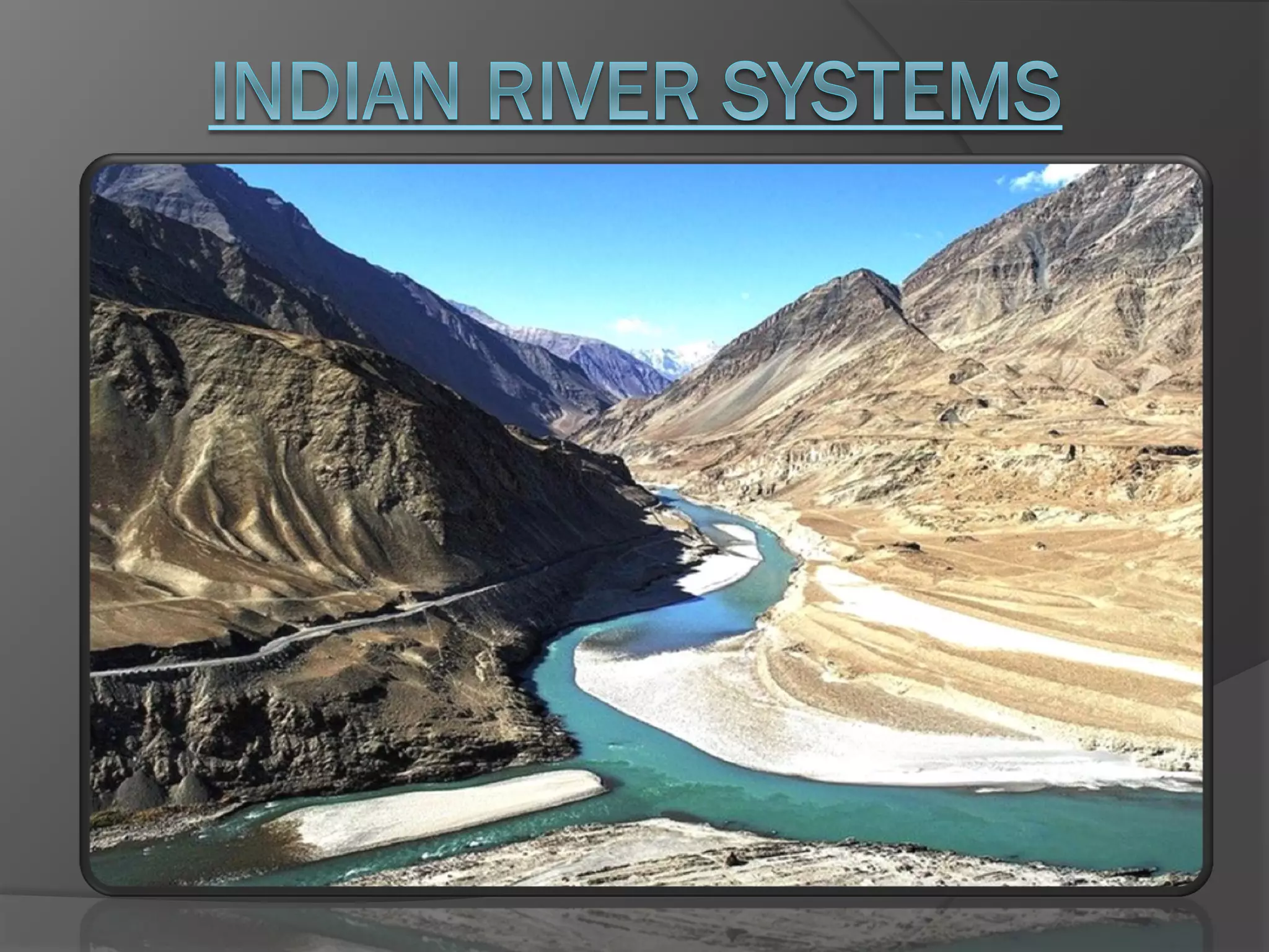
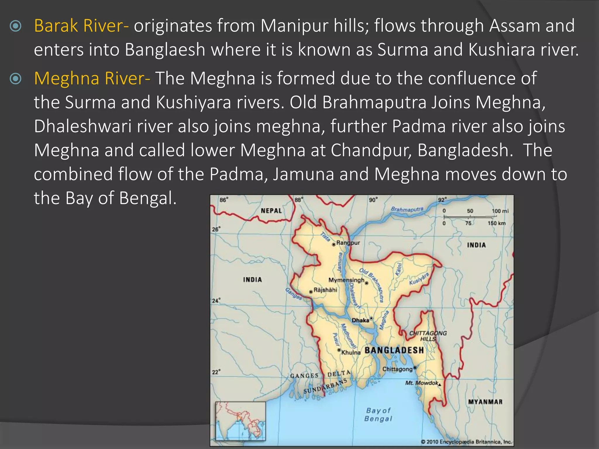
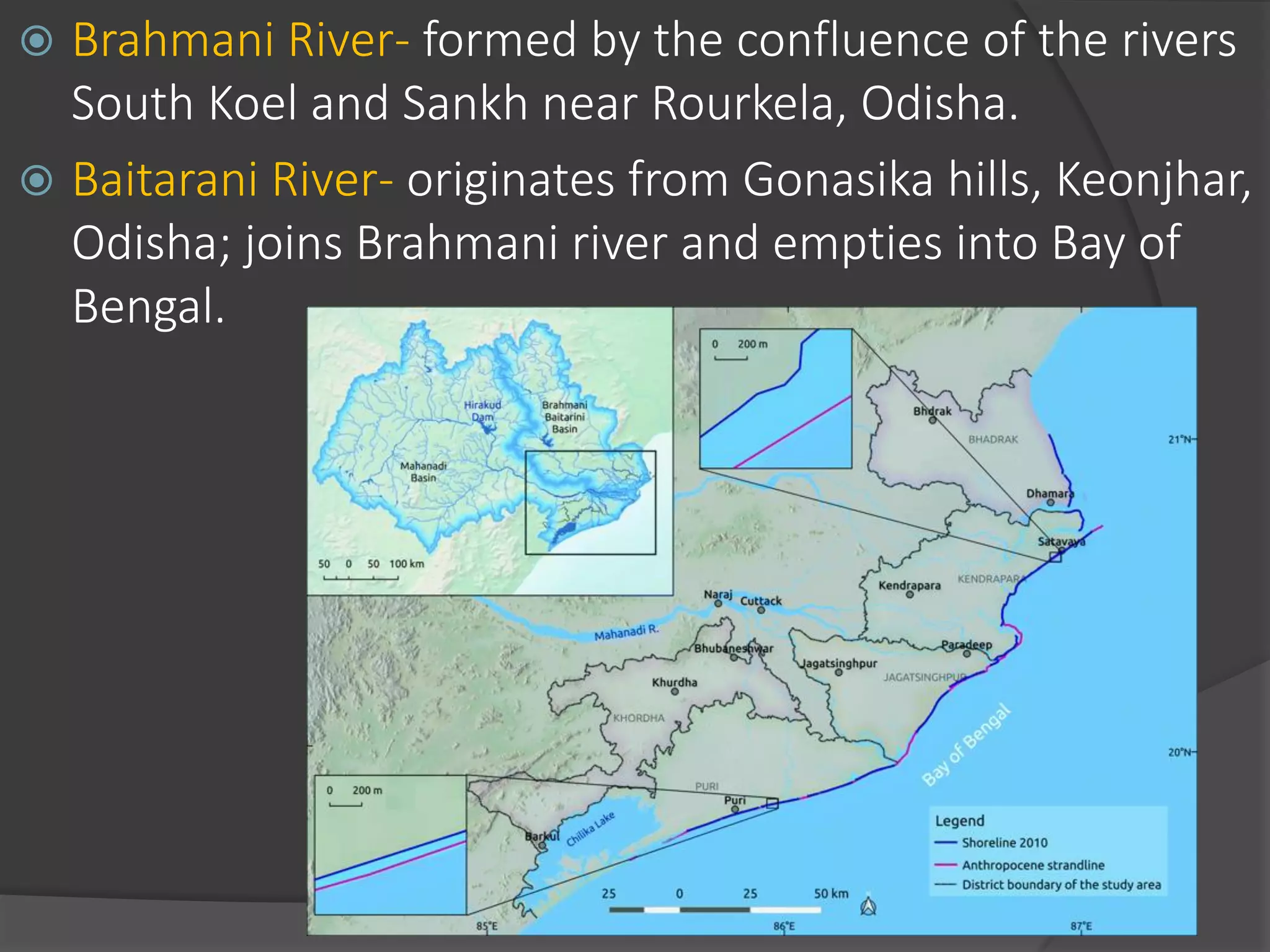
The document summarizes the major river systems of India - the Indus, Brahmaputra, and Ganga. It provides details on the source, length, tributaries, and course of each river. For the Indus and Brahmaputra, it lists the countries they pass through and their mountain ranges. It then describes the major tributaries of each river in India, providing information on their source and where they join the main river.
This one is related to one of the most auspicious states of our country India. follow the provided ppt. with your friends and family members. so, let them know more about the state i.e., Tamil Nadu
Tamil Nadu is the southernmost state of India located on the southeastern tip of the Indian peninsula. It has a long history and was home to ancient Tamil cultures and kingdoms. The state has a diverse geography ranging from forests and hills to coastlines and fertile plains. It has a tropical climate and receives both winter and summer rainfall. Tamil Nadu has a robust economy and is one of the most industrialized states in India, supported by resources like forests, rivers, and mineral deposits. The state has a unicameral legislative assembly and is divided into districts, corporations, and other local administrative units.
This document provides an overview of Ladakh, a region in northern India. It discusses Ladakh's brief history as an important trading route between Central Asia and South Asia. It then covers Ladakh's geography, climate, flora and fauna, costumes, economy, and transportation. The main points are that Ladakh has a high altitude plateau environment and population of Tibetan and other ethnic groups. It was historically an important trading route but now relies on its military, tourism, and government jobs for its economy.
Adorned by the great Himalayas, Ladakh resides in the lap of Jammu and Kashmir. The place offers exquisite beauty and traces of rich Tibetan culture, uniquely matched with rugged trails and rollick adventures. Wrap yourself in the fresh frosty weather with a visit to these five most loved destinations in Ladakh. https://www.thomascook.in/tcportal/ladakh-tourism
Rajasthan is the largest state in India by area. It encompasses most of the Thar Desert and shares borders with several other Indian states as well as Pakistan. Rajasthan has a population of over 68 million and its economy is primarily based on agriculture, with wheat, barley and other crops being important. The state contains several national parks and wildlife sanctuaries that are home to endangered species such as the Great Indian Bustard.
These slides were designed by me for my class Presentation. This is not a professional one as I have copied images and slides and information from web, but the construction (formation) of this presentation is by me. Presentation consists the Travel, culture, site seeing, Geography and Festival of Ladhak Area.
Karnataka is a state located in southern India with a population of over 61 million people according to the 2011 census. Kannada is the official language, spoken by 66% of residents, while other languages include Urdu, Tamil, Telugu, Hindi, and Malayalam. The state has a diverse landscape from coastal plains to forested hills and a long history of dynasties that have contributed greatly to Karnataka's culture and development.
Jharkhand is a state in eastern India with a total area of 79,714 square kilometers and a population of over 32 million people. Some of the most popular cities to visit are Ranchi, the capital, as well as Jamshedpur, Hazaribagh, Chatra, Dhanbad, and Palamu. The best time to visit is between October and March when temperatures are mild. Popular tourist attractions include national parks, temples, waterfalls, and places of natural beauty.
Location: Himachal Pradesh
Main Wildlife Attractions: snow leopard, Himalayan brown bear, Himalayan thar, blue sheep
Coverage Area: 1171 sq.kms.
Established: 1984
Best Time to Visit : April to June and September to November
The document provides an overview of the Indian state of Haryana, including its history, geography, population, districts, literacy rates, culture, climate, tourism spots, agriculture, rivers, connectivity, food habits, festivals, traditional costumes, sports, film industry, industrial hubs, and some notable personalities from Haryana. Key details are provided on the capital city of Chandigarh, date of formation, official languages, size, population, state animal, bird, flower, tree and current chief minister.
Karnataka is the eighth largest state in India located in South West India. It has a population of over 52 million people and Bangalore is the capital and largest city. Karnataka has a diverse landscape ranging from coastal regions to hilly Western Ghat mountain ranges. It has a long history and was previously known as the state of Mysore. Karnataka is known for its cultural heritage, religious sites, beaches, waterfalls, and biodiversity with national parks and forests. Tourism is an important industry in Karnataka alongside technology industries concentrated in Bangalore.
Rajasthan is the largest state in India by area. It has a rich history and culture as evidenced by its many forts and palaces. Some significant festivals in Rajasthan include the Pushkar Camel Fair, Karni Mata Fair, and Gangaur Festival. Rajasthani cuisine is known for being hardy and flavorful using ingredients like coconut, chilies, and vinegar. The state has several national parks and wildlife sanctuaries that are home to species like the tiger and great Indian bustard.
Karnataka is an enormous state located in Southwestern India. It is surrounded by other major Indian states and contains diverse geography from coastal regions to plateaus. Karnataka has a population of over 52 million people and a state GDP of $34.41 billion. The state has a long history and was previously known as Mysore. It is known for being a center of education, technology, literature, and classical Indian music. Bangalore is the capital and largest city, and has become a major hub for the technology industry.
- In ancient times, Rajasthan was divided into several small territories and janapadas (clans), identified by geographical names or the dominant caste, such as Marwar, Mewar, etc.
- These janapadas emerged as Aryan tribes merged smaller settlements and established their own states. They included Maru, Jaangal, Matsya, Shoorsen, Shivi, Arjunayan, Malav and Yodhey.
- Over time, some janapadas grew in power and their names came to identify broader regions, such as Marwar, Mewar, Hadauti, Dhundhad, and Mewat. Rajasthan's diverse history is
Haryana is a state in Northern India with its capital in Chandigarh. It was carved out of the former state of East Punjab in 1966 on the basis of language. Haryana has a population of over 21 million people and borders Punjab, Himachal Pradesh, Rajasthan, and Uttar Pradesh. The state has a rich cultural heritage dating back to ancient civilizations. It has a hot climate and is a leading producer of food grains and milk in India. Literacy rates have increased significantly in recent decades.
Comparison between The Haryana and The Telangana State of IndiaNancyGarg30
This PPT relates to the comparison between lifestyles of the different states of the India i.e. Haryana and Telangana. You will get full and deep knowledge about the concept.
Haryana is a state located in northern India between 27°39' to 30°35' N latitude and 74°28' and 77°36' E longitude. It has four main geographical features - the Yamuna-Ghaggar plain, Shivalik Hills, semi-desert sandy plain, and Aravalli Range. The state has a hot summer and cold winter climate with monsoon rains from July to September. Major rivers include the Yamuna, Ghaggar, and Markanda. Flora includes thorny shrubs and deciduous forests, and fauna includes black buck, nilgai, and various birds.
This document provides an overview of the culture of Ladakh, a region in northern India. It first introduces Ladakh and discusses its history under Gulab Singh and incorporation into Jammu and Kashmir. The document then summarizes some key aspects of Ladakh's culture, including its religions of Buddhism, Islam, and Hinduism; language of Ladakhi; traditional arts and crafts like pashmina; and folk dances. The cuisine, music, and architecture of Ladakh are also briefly described.
Rajputs are a Hindu warrior class that originated in North India. They claim descent from royal Hindu clans and rose to prominence between the 6th-12th centuries when they ruled many princely states in Rajasthan and Gujarat. Rajputs are divided into subgroups based on claimed descent from solar, lunar, or fire deities. They had a martial culture and ruled much of North India until the 20th century when the British dissolved the princely states.
This document provides information about the cultural exchange program between the Indian states of Telangana and Haryana. It summarizes some of the key cultural aspects of Telangana, including festivals like Bonalu and Bathukamma, folk dances like Lambadi and Gusadi, and the musical instrument Adivasi Nagara. The document also briefly discusses Telangana's textiles, cuisine, and biodiversity. The cultural exchange program aims to share Telangana's rich cultural traditions with people from Haryana state.
Its capital and largest city is Chennai (formerly known as Madras). Tamil Nadu lies in the southernmost part of the Indian Peninsula and is bordered by the union territory of Puducherry and the South Indian states of Kerala, Karnataka, and Andhra Pradesh.
Punjab is a state in northwest India with a population of over 27 million. Its capital is Chandigarh and it borders Pakistan to the west. Punjab has a fertile alluvial plain watered by five rivers and is known as the breadbasket of India. The state experiences frequent flooding from rivers like the Ravi, Satluj, and Ghaggar. Amritsar is a major city and district in Punjab known for its Golden Temple, a highly revered site for Sikhs. It has a population density of over 900 people per square kilometer concentrated in the central core of the city. Tourism is an important industry in both Punjab as a whole and Amritsar specifically, focused around religious sites.
Kathak is a classical dance form that originated in northern India. The word Kathak comes from "katha" meaning story and "kathakar" meaning storyteller. In ancient times, nomadic performers called kathakas would recite stories from Hindu epics through a combination of dance, music, and mime. Over time, Kathak developed different styles at royal courts. Today it is one of the eight classical Indian dance forms and is practiced in various styles passed down through generational gurus.
This is a presentation on the country, India. India, officially the Republic of India (Hindi: भारत गणराज्य is a country in South Asia. It is the seventh-largest country by geographical area, the second-most populous country, and the most populous democracy in the world. Bounded by the Indian Ocean on the south, the Arabian Sea on the west, and the Bay of Bengal on the east, India has a coastline of 7,517 kilometres (4,700 mi).It is bordered by Pakistan to the west;People's Republic of China, Nepal, and Bhutan to the north; and Bangladesh and Myanmar to the east. India is in the vicinity of Sri Lanka, the Maldives, and Indonesia in the Indian Ocean.
Telangana has a rich cultural history spanning over 5,000 years. It was a center of culture under dynasties like the Kakatiyas, Qutb Shahis, and Asaf Jahis. The region has important historical monuments from these eras like the Ramappa Temple and Warangal Fort. Hinduism and Islam are the major religions practiced in Telangana, as seen in temples like Bhadrachalam and the historic Mecca Masjid. The state celebrates festivals like Bonalu and Batukamma as well as national festivals. Telugu and Hyderabadi cuisine like biryani and Sakinalu are part of the local culture. Performing arts include Perini
Tamil Nadu has an area of 130,058 sq km and a population of over 7 crore people. The capital is Chennai and the predominant language is Tamil. The state has a long history with various dynasties ruling at different times. The main industries are cotton, vehicles, IT and biotechnology. Agriculture is the main occupation with crops like rice, sugarcane and coconut grown. Tamil Nadu has many festivals celebrating local culture and religion as well as dance and music performances that attract tourists throughout the year.
Harshavardhana was born in Thaneswar, Haryana in the Pushyabhuti or Vardhana Dynasty and reigned from AD 606-647. He became king at age 16 after his brother Rajyavardhana was killed by Sasanka, the Gauda king of West Bengal who had also imprisoned Harshavardhana's sister Rajyashri. Harshavardhana then defeated Sasanka and expanded his kingdom to include the region south until the Narmada River. During his reign, he supported Buddhism and oversaw the development of sites like Nalanda University.
The document summarizes the drainage systems of India. It discusses the two main systems - the Himalayan and Peninsular systems. The Himalayan rivers are perennial while peninsular rivers are seasonal. It also describes the three main Himalayan river systems - the Indus, Brahmaputra and Ganga; and lists their key tributaries. Major multi-purpose projects built on the rivers are also outlined.
The document summarizes the drainage systems of India. It discusses the two main systems - the Himalayan and Peninsular systems. The Himalayan rivers are perennial while the Peninsular rivers are seasonal. It also describes the three main Himalayan river systems - the Indus, Brahmaputra and Ganga noting key details about each river including their source and length. The document provides information on some of the major dams and projects along various rivers.
The document summarizes the major river systems of India. It describes the three main Himalayan river systems: the Indus system, the Ganga system, and the Brahmaputra system. It provides details on the Indus system such as its source near Mansarovar Lake in Tibet, its total length of 3,202 km, and its five major tributaries - the Chenab, Jhelum, Ravi, Sutlej, and Beas rivers. It also briefly discusses the Ganga and peninsular river systems and the geographical features of northern, peninsular, and coastal plains in India.
The document summarizes the major river systems of India. It discusses the Himalayan rivers including the Ganga, Indus, and Brahmaputra systems. It also describes the peninsular rivers including the Narmada, Tapi, Godavari, Krishna, Kaveri and Mahanadi. It provides details on the origin and tributaries of these major rivers as well as the mountain ranges that feed different river basins across India.
The term river system refers to a ‘river along with its tributaries’.
Based on their source, the Indian River system is classified in to - Himalayan Rivers and Peninsular Rivers.
The Himalayan Rivers, as the name suggests originate from the Himalayas and flow through the Northern Plains.
The major Himalayan River systems are
The Indus River System,
The Ganga River System
The Yamuna River System
The Brahmaputra River System
Peninsular River System or Peninsular Drainage emerges mainly from the Western Ghats. Since the Western Ghats form a ‘water divide’, these rivers either flow eastwards into the Bay of Bengal or into the Arabian Sea towards the west. Peninsular Rivers are basically ‘rain fed’ rivers.
The major Peninsular River Systems are:
Mahanadi
Godavari
Krishna
Cauvery
Drain into Bay of Bengal as they flow eastwards on the plateau and make ‘deltas’ at their mouths; whereas Narmada
Tapti - the west flowing rivers fall into the Arabian Sea and make ‘estuaries’.
not originate in glaciers, but are rain fed rivers. These rivers reduce considerably or dry up during summers.
- The major rivers of India play an important role in providing irrigation, water, transportation, electricity and livelihoods. Nearly all major cities are located on river banks.
- There are seven major river systems - the Ganga, Indus, Brahmaputra, Narmada, Godavari, Krishna and Mahanadi. Most rivers drain into the Bay of Bengal while some flow west towards the Arabian Sea.
- The rivers are classified based on their origin - the Himalayan rivers originate in the Himalayas and form large basins, while peninsular rivers flow through shallow valleys and many are seasonal.
The document discusses India's drainage systems and major rivers. It describes how the country's rivers are divided into two groups: the Himalayan rivers and peninsular rivers. The Himalayan rivers, such as the Ganges, Brahmaputra, and Indus, originate from glaciers and have large catchment areas. In contrast, the peninsular rivers like the Narmada, Tapti, and Godavari originate from plateaus and have smaller catchment areas. It provides key details about the courses and tributaries of major rivers like the Ganges, Brahmaputra, Narmada, Godavari, and Krishna.
The major river systems of India originate from three watersheds in the Himalayas. The seven major rivers are the Indus, Ganges, Brahmaputra, Narmada, Tapti, Godavari and Mahanadi. The Himalayan rivers like the Indus, Ganges and Brahmaputra flow from north to south through the plains while peninsular rivers flow south through shallow valleys. Many rivers are considered sacred in Hindu mythology like the Ganges, Yamuna and Kaveri which are personified as goddesses.
The major rivers of the Himalayas are the Indus, Ganges, and Brahmaputra. These long rivers originate from glaciers and lakes in the Himalayas and flow through India, joining with many tributaries before emptying into the sea. The Indus flows west through India and Pakistan, picking up tributaries like the Zaskar and Shyok. The Ganges originates from Gangotri Glacier and flows north, receiving water from tributaries such as the Yamuna. The Brahmaputra flows east from its source in Tibet before turning west and flowing through India, joined by tributaries including the Dibang and Lohit rivers.
India's drainage systems are divided into two groups - the Himalayan rivers and the Peninsular rivers. The Himalayan rivers are perennial and flow from the Himalayas, while the Peninsular rivers are seasonal and originate in the Western Ghats. Some key Himalayan rivers are the Indus, Ganges, and Brahmaputra, while major Peninsular rivers include the Godavari, Mahanadi, Krishna, and Kaveri. India also has many lakes that vary in size and origin, such as glacial lakes in the Himalayas and coastal lagoons. Rivers and lakes play an important economic and environmental role but are increasingly threatened by pollution.
River long water course that flows down a slope along a bed between banks. It originates from a 'source' and culminates to a sea or lake at its 'mouth'. Along its length it may be joined by smaller rivers called 'tributaries'. A river and its tributaries form a 'river system'. Land surfaces are never perfectly flat, and as a result the runoff water after precipitation tends to flow downward by the shortest and steepest course in depressions formed by the intersection of slopes. Runoff water of sufficient volume and velocity join to form a stream that, by the erosion of underlying earth and rock, becomes deep enough to be fed ground water or when it has as its source an ultimate water reservoir, for example, the ganges flowing from the Gangotri Glacier and the brahmaputra from the Manas Sarovar.
This document summarizes the drainage systems and major rivers in India. It divides India's rivers into two groups: the Himalayan rivers which originate in the Himalayas and have large catchment areas, and the peninsular rivers which originate in the peninsular plateaus and have smaller catchment areas. It provides details on key Himalayan rivers like the Ganges, Brahmaputra, and Indus, and peninsular rivers such as the Narmada, Tapti, Godavari, Mahanadi, Krishna, and Kaveri. It also discusses the benefits rivers provide like fresh water, irrigation, navigation and hydroelectric power generation.
The document summarizes the major rivers of India. It discusses the five most important rivers: Ganga, Saraswati, Sindhu, Godavari, and Narmada. It also briefly describes other notable rivers such as the Indus River and its five tributaries, Yamuna River, Krishna River, Kaveri River, Brahmaputra River, and Tapi River. The rivers are considered sacred in Hinduism and have played an important role in Indian culture and civilization.
This document discusses flood management and provides information about floods and flood alleviation in India. It begins by defining floods and their causes, including heavy rainfall, snowmelt, and storm surges. It then discusses the dangers of floods, including deaths from drowning. The document outlines design floods and the maximum flood a structure can withstand. It provides details about major rivers in India, including their origins and courses. It discusses the types of floods that occur in India and flood-prone areas. The effects of floods are outlined. Finally, it describes methods used for flood alleviation and control structures like levees.
The document summarizes the key rivers of Himachal Pradesh, including their Sanskrit names, origins, tributaries, and salient features. It discusses the Beas, Sutlej, Chenab, Yamuna, and Ravi Rivers, noting their lengths, catchment areas within Himachal Pradesh, and paths through the state before merging with other rivers or crossing borders. The longest river is the Sutlej and the largest in terms of water volume is the Chenab, while the Yamuna has the smallest catchment area within Himachal Pradesh.
This document provides a summary of a social science presentation on drainage systems and rivers in India. It includes sections on the Himalayan rivers like the Indus, Ganges, and Brahmaputra rivers and their routes. It also discusses the peninsular rivers including the Narmada, Tapi, Godavari, Mahanadi, Krishna, and Kaveri rivers. There is also information on lakes, the role of rivers in the economy, comparisons between Himalayan and peninsular rivers, drainage patterns, river pollution causes and effects, and ways to reduce river pollution.
The document summarizes the major river systems and lakes in India. It describes the two main classifications of rivers as Himalayan and Peninsular. The key Himalayan rivers are the Indus, Ganges, and Brahmaputra, along with their major tributaries. It also outlines the major east and west flowing Peninsular rivers such as the Mahanadi, Godavari, Krishna, and Narmada. Finally, it briefly mentions some of India's significant lakes, including Chilka Lake, Wular Lake, and Sambhar Lake.
The document provides information about several major rivers in the Himalayan region and India, including the Indus, Ganges, and Brahmaputra rivers. It discusses the origins and paths of these rivers, as well as some myths and legends associated with them. It also summarizes key details about other important rivers in India like the Godavari, Mahanadi, Krishna, Kaveri, Narmada, and Tapi rivers. Additionally, it briefly describes two notable lakes, Dal Lake in Kashmir and Loktak Lake in Manipur.
The document discusses drainage patterns and India's major river systems. It describes the key features of the Himalayan rivers including the Indus, Ganges, and Brahmaputra as well as major peninsular rivers such as the Narmada, Godavari, Mahanadi, Krishna and Kaveri. It explains that the Himalayan rivers are fed by snowmelt and rain and have long courses with many tributaries, while peninsular rivers have shorter courses and drainage basins.
This document outlines the qualifications, disqualifications, and conditions for vacating seats for members of parliament (MPs) in India. MPs must be Indian citizens over the age of 25 for the Lok Sabha or 30 for the Rajya Sabha. They can be disqualified for holding an office of profit, unsoundness of mind, being an undischarged insolvent, ceasing to be a citizen of India, or defecting by changing their political party affiliation. The presiding officers of each house, such as the Speaker of the Lok Sabha, decide on disqualification cases. Grounds for vacating a seat include resignation, extended absence, or taking up another office such as the presidency.
Recent archaeological discoveries and events related to art, culture and heritage were reported in India between 2019-2020. Notable among these were:
1) The discovery of large ancient menhirs (erected stone slabs) on Pothamala hills in Kerala-Tamil Nadu border dating back 3000 years.
2) The Chaukhandi stupa in Sarnath, UP being declared a site of national importance. It has a brick structure built by Emperor Ashoka, with an octagonal tower added by Mughal emperor Humayun.
3) An unearthed Buddhist relic in Andhra Pradesh exhibiting features of the ancient Amaravati school of art from the Ikshv
The document summarizes India's citizenship rules and amendments. Key points include:
- Indian citizenship can be acquired by birth, descent, registration, naturalization, or incorporation of territory.
- Rights of Indian citizens include non-discrimination, equality, freedom of speech/movement, voting rights.
- The Citizenship Act of 1955 and its amendments govern acquisition and loss of citizenship.
- The Citizenship Amendment Act of 2019 provides a path to citizenship for religious minorities fleeing neighboring countries.
- Special provisions exist for Assam regarding detection and registration of immigrants before certain cutoff dates.
Governor generals and Viceroys of India and important eventsDiksha Sharma
The document provides information on important governors-general and viceroys of British India between 1772-1856 and some key events that occurred during their tenures. It notes that Warren Hastings was the first governor-general who established the Supreme Court and introduced the ijaredari system. Lord Cornwallis introduced civil services and a permanent land tax system. The document also summarizes Lord Dalhousie's doctrine of lapse policy and railway expansion under his leadership. Finally, it mentions the major rebellions and wars that occurred such as the Sepoy Mutiny of 1857.
The document provides information on the history of painting in India from prehistoric to Mughal periods. It discusses paintings found in ancient cave sites like Ajanta and Ellora dating from 2nd century BC to 10th century AD depicting religious themes. The Mughal style evolved under Akbar in the 16th century by synthesizing indigenous Indian and Persian styles, known for naturalism and fine detail. Major painting traditions across India are described, along with materials and techniques used.
The document provides information on several UNESCO World Heritage sites located in India. It discusses the World Heritage Convention of 1972 and lists 38 properties in India that are inscribed on the World Heritage List, including cultural sites like the Agra Fort, Taj Mahal, Ajanta Caves, Ellora Caves, and Group of Monuments at Mahabalipuram. It provides brief summaries of these prominent Indian world heritage sites, noting their historical and architectural significance.
The Nilgiri Biosphere Reserve is located in southern India across Tamil Nadu, Kerala, and Karnataka states. It contains several protected areas and is home to a diversity of wildlife including tiger and lion-tailed macaque. Several ethnic tribes inhabit the area and practice different livelihoods such as farming, herding, and foraging. The biosphere reserve aims to protect its unique ecosystems and biodiversity through its system of core, buffer, and transition zones.
Critically endangered animal species of indiaDiksha Sharma
This document discusses several critically endangered animal species found in India. It provides information on the IUCN Red List criteria for critically endangered species and then profiles 16 different critically endangered species found in India, including the Pygmy Hog, Andaman White-toothed Shrew, Kondana Rat, Elvira Rat, Namdapha Flying Squirrel, Malabar Civet, Jerdon's Courser, Forest Owlet, White-bellied Heron, four species of vultures, Bengal Florican, Himalayan Quail, Pink-headed Duck, Sociable Lapwing, and Spoon-billed Sandpiper. For each species, it provides details on habitat, distribution, and threats.
The Convention on Migratory Species (CMS) aims to conserve migratory species and their habitats across national borders. Also known as the Bonn Convention, it was signed in 1979 in Bonn, Germany and has 129 member states. The CMS appendices list migratory species that are endangered (Appendix I) and conserved through international agreements (Appendix II). The Conference of Parties meets every three years to review implementation. India is a signatory and hosts many migratory species covered by the CMS under various agreements and national action plans. Three species added new protections under CMS at COP13 were the Asian elephant, Great Indian bustard, and Bengal florican.
The UNCCD was established in 1994 as the sole legally binding agreement linking environment, development, and sustainable land management. It addresses issues in dryland areas and aims to improve living conditions, maintain land productivity, and mitigate drought effects. The UNCCD collaborates with the CBD and UNFCCC for an integrated approach. Desertification is defined as land degradation resulting from climate and human factors. The COP is the governing body that meets biennially to review country reports and make recommendations. Five regions implement the convention through annexes focusing on monitoring, agroforestry, and more. India hosted COP14 in 2019 and initiatives were adopted around restoration, climate action, and engaging sectors like youth and private.
The Convention on Wetlands, also known as the Ramsar Convention, is an intergovernmental treaty established in 1971 to protect wetland habitats. It aims to conserve and promote sustainable use of wetlands globally through local, national, and international cooperation. Key points of the Ramsar Convention include designating Wetlands of International Importance, also called Ramsar sites, promoting wise use of all wetlands, and cooperating on transboundary wetland management. India has designated 37 Ramsar sites covering over 1 million hectares to protect important wetland habitats and species within its territory.
The document discusses various socio-religious reform movements in 19th century India that aimed to modernize religious outlooks and reform social institutions. Some of the key movements mentioned are Brahmo Samaj, Prarthana Samaj, Arya Samaj, Ramakrishna Mission, Theosophical Society, Satya Shodhak Samaj and movements led by Pandita Ramabai and Sri Narayana Guru that advocated for women's rights and upliftment of depressed classes. Islamic reform movements like Deoband Movement and Aligarh Movement as well as Parsi, Sikh and other minor reform movements are also summarized.
Delimitation is the process of fixing the boundaries of territorial constituencies. In India, delimitation commissions are constituted under the Delimitation Acts of 1952, 1962, 1972, and 2002 after each census to redistribute constituencies. The commissions, appointed by the President, are headed by a retired Supreme Court judge and include the Chief Election Commissioner. Their task is to determine constituencies of equal population size and reserve seats for underrepresented groups. The commissions' orders have the force of law and cannot be challenged in court.
The Bhakti movement originated in India as a religious concept of devotional surrender to a supreme god for salvation. It emerged in opposition to Jainism and Buddhism which were supported by merchants and the state. Bhakti exponents believed devotion could overcome fate unlike these other religions. The movement was spread by many poet-saints from the 7th-10th centuries in South India and later all of India from the 14th century onward. Key figures included Ramananda, Chaitanya, Mirabai, Sur Das, Kabir, Nanak, Ravidas, and Namadeva who composed devotional poems in local languages to spread the message of bhakti.
The document summarizes several important economic indices mentioned in the Economic Survey, including India's rankings in 2019 for indices such as Ease of Doing Business (63), Corruption Perception Index (80), Global Economic Freedom Index (79), Global Innovation Index (52), and Global Competitiveness Report (68). It also provides details on indices such as Logistics Performance Index (44), Logistics Ease Across Different States, SDG India Index, and Shannon-Weiner Index.
A review of the growth of the Israel Genealogy Research Association Database Collection for the last 12 months. Our collection is now passed the 3 million mark and still growing. See which archives have contributed the most. See the different types of records we have, and which years have had records added. You can also see what we have for the future.
Exploiting Artificial Intelligence for Empowering Researchers and Faculty, In...Dr. Vinod Kumar Kanvaria
Exploiting Artificial Intelligence for Empowering Researchers and Faculty,
International FDP on Fundamentals of Research in Social Sciences
at Integral University, Lucknow, 06.06.2024
By Dr. Vinod Kumar Kanvaria
How to Build a Module in Odoo 17 Using the Scaffold MethodCeline George
Odoo provides an option for creating a module by using a single line command. By using this command the user can make a whole structure of a module. It is very easy for a beginner to make a module. There is no need to make each file manually. This slide will show how to create a module using the scaffold method.
LAND USE LAND COVER AND NDVI OF MIRZAPUR DISTRICT, UPRAHUL
This Dissertation explores the particular circumstances of Mirzapur, a region located in the
core of India. Mirzapur, with its varied terrains and abundant biodiversity, offers an optimal
environment for investigating the changes in vegetation cover dynamics. Our study utilizes
advanced technologies such as GIS (Geographic Information Systems) and Remote sensing to
analyze the transformations that have taken place over the course of a decade.
The complex relationship between human activities and the environment has been the focus
of extensive research and worry. As the global community grapples with swift urbanization,
population expansion, and economic progress, the effects on natural ecosystems are becoming
more evident. A crucial element of this impact is the alteration of vegetation cover, which plays a
significant role in maintaining the ecological equilibrium of our planet.Land serves as the foundation for all human activities and provides the necessary materials for
these activities. As the most crucial natural resource, its utilization by humans results in different
'Land uses,' which are determined by both human activities and the physical characteristics of the
land.
The utilization of land is impacted by human needs and environmental factors. In countries
like India, rapid population growth and the emphasis on extensive resource exploitation can lead
to significant land degradation, adversely affecting the region's land cover.
Therefore, human intervention has significantly influenced land use patterns over many
centuries, evolving its structure over time and space. In the present era, these changes have
accelerated due to factors such as agriculture and urbanization. Information regarding land use and
cover is essential for various planning and management tasks related to the Earth's surface,
providing crucial environmental data for scientific, resource management, policy purposes, and
diverse human activities.
Accurate understanding of land use and cover is imperative for the development planning
of any area. Consequently, a wide range of professionals, including earth system scientists, land
and water managers, and urban planners, are interested in obtaining data on land use and cover
changes, conversion trends, and other related patterns. The spatial dimensions of land use and
cover support policymakers and scientists in making well-informed decisions, as alterations in
these patterns indicate shifts in economic and social conditions. Monitoring such changes with the
help of Advanced technologies like Remote Sensing and Geographic Information Systems is
crucial for coordinated efforts across different administrative levels. Advanced technologies like
Remote Sensing and Geographic Information Systems
9
Changes in vegetation cover refer to variations in the distribution, composition, and overall
structure of plant communities across different temporal and spatial scales. These changes can
occur natural.
বাংলাদেশের অর্থনৈতিক সমীক্ষা ২০২৪ [Bangladesh Economic Review 2024 Bangla.pdf] কম্পিউটার , ট্যাব ও স্মার্ট ফোন ভার্সন সহ সম্পূর্ণ বাংলা ই-বুক বা pdf বই " সুচিপত্র ...বুকমার্ক মেনু 🔖 ও হাইপার লিংক মেনু 📝👆 যুক্ত ..
আমাদের সবার জন্য খুব খুব গুরুত্বপূর্ণ একটি বই ..বিসিএস, ব্যাংক, ইউনিভার্সিটি ভর্তি ও যে কোন প্রতিযোগিতা মূলক পরীক্ষার জন্য এর খুব ইম্পরট্যান্ট একটি বিষয় ...তাছাড়া বাংলাদেশের সাম্প্রতিক যে কোন ডাটা বা তথ্য এই বইতে পাবেন ...
তাই একজন নাগরিক হিসাবে এই তথ্য গুলো আপনার জানা প্রয়োজন ...।
বিসিএস ও ব্যাংক এর লিখিত পরীক্ষা ...+এছাড়া মাধ্যমিক ও উচ্চমাধ্যমিকের স্টুডেন্টদের জন্য অনেক কাজে আসবে ...
Main Java[All of the Base Concepts}.docxadhitya5119
This is part 1 of my Java Learning Journey. This Contains Custom methods, classes, constructors, packages, multithreading , try- catch block, finally block and more.
How to Setup Warehouse & Location in Odoo 17 InventoryCeline George
In this slide, we'll explore how to set up warehouses and locations in Odoo 17 Inventory. This will help us manage our stock effectively, track inventory levels, and streamline warehouse operations.
The simplified electron and muon model, Oscillating Spacetime: The Foundation...RitikBhardwaj56
Discover the Simplified Electron and Muon Model: A New Wave-Based Approach to Understanding Particles delves into a groundbreaking theory that presents electrons and muons as rotating soliton waves within oscillating spacetime. Geared towards students, researchers, and science buffs, this book breaks down complex ideas into simple explanations. It covers topics such as electron waves, temporal dynamics, and the implications of this model on particle physics. With clear illustrations and easy-to-follow explanations, readers will gain a new outlook on the universe's fundamental nature.
How to Fix the Import Error in the Odoo 17Celine George
An import error occurs when a program fails to import a module or library, disrupting its execution. In languages like Python, this issue arises when the specified module cannot be found or accessed, hindering the program's functionality. Resolving import errors is crucial for maintaining smooth software operation and uninterrupted development processes.
2. The rivers of India can be classified into four groups
viz., Himalayan rivers, Deccan rivers, Coastal rivers,
and Rivers of the inland drainage basin.
The Himalayan Rivers are formed by melting snow and
glaciers and therefore, continuously flow throughout the
year. During the monsoon months, Himalayas receive very
heavy rainfall and rivers swell, causing frequent floods.
The Deccan Rivers on the other hand are rain fed and
therefore fluctuate in volume. Many of these are non-
perennial.
The Coastal streams, especially on the west coast are short
in length and have limited catchment areas. Most of them
are non-perennial.
The streams of inland drainage basin of western Rajasthan
are few. Most of them are of an ephemeral character.
5. Country- China, India, Pakistan
Source- Tibetan plateau, Mount Kailash glaciers, China
Length- 2897 km, 709 km in India
Discharge- Indus River Delta, Arabian sea, Pakistan and Kori
creek, Runn of Kutch of India
Names- Sênggê Zangbo and Lion river in Tibet, Sindhu in
Hindi, Satnad River in Pakistan
Mountain Ranges- Kailash (China), karakoram, Deosai,
Ladakh, Zaskar, Pir Panjal, Shiwalik, Dhauladhar (India),
Nanga Parbat, Hindu kush, Sulaiman, Kirthar (Pakistan)
Endangered Wildlife- Indus Dolphin, Eurasian Otter, Sindh
Otter, Golden Masheer, Catfish
6. Tributaries
Gar Tsangpo in Tibet
Indian Tributaries-
Zaskar River- It is a left bank tributary of Indus; Originated
from Bara Lacha La in Himachal Pradesh; Doda and Tsarap
rivers are two main tributaries; joins the Indus near
"Nimmu" in Ladakh.
Shyok River- It is a right bank tributary; Originates at Rimo
glacier, near Siachin; Nubra and Saltoro are two major
tributaries; joins the Indus at Keris, east of the town
of Skardu.
Gilgit River- right bank tributary; starts from Shandur Lake
(Pakistan); Hunja river is main tributary; joins the Indus
River at junction point of three mountains ranges near
town of Juglot (Karakoram, Hindukush and Himalayas).
Shigar River- right bank tributary; starts from Baltoro
glacier (Pakistan); Joins the Indus in Skardu Valley.
7. Suru River- left bank tributary; originates from the Panzella
glacier; flows entirely in Kargil Distt; Dras river is the main
tributary; joins Indus at Nurla, Skardu.
Panjnad River- left bank tributary; this is a river in Punjab,
Pakistan. Panjnad is formed by successive confluence or
merger of the five rivers of the Punjab, namely Jhelum,
Chenab, Ravi, Beas and Sutlej. Jhelum and Ravi join Chenab,
Beas joins Sutlej, and then Sutlej and Chenab join to form
Panjnad in Muzaffar Garh district. The combined stream
runs southwest for approximately 45 miles and joins
the Indus River at Mithankot.
Jhelum River- Vitasta(Sanskrit), Hydaspes(Greek),
Bihat(Urdu); Originates from Verinag spring, Anantnag Distt
Merges with Chenab river at Jhang, Pakistan
Forms Wular Lake in Bandipora distt.
Lidder, Sind, Kishenganga, Kunhar, Poonch rivers are major
tributaries.
8. Chenab River- Askini(Sanskrit); The river is formed by the
confluence of two rivers, Chandra(originates from Sura Taal
lake) and Bhaga(originates from glaciers of Bara Lacha La), at
Tandi, in the Lahaul and Spiti district in the Himachal
Pradesh; Marusadar river is main tributary, merges with
Jhelum and Ravi and Sutlej to form Panjad river.
Ravi River- Iravati, Parushni (Sanskrit), Hydraotes (Greek);
originates from Barabangal glaciers Kangra distt, Himachal
Pradesh; Buhil, Nai, Seul, Siawa, Tant Gari are major
tributaries; merges with Chenab river at Ahmadpur sial distt
of Pakistan; Lahore city is on eastern bank.
Beas River- Vipasa(Sanskrit), Bias(Hindi), Hypasis(Greek);
Originates from Beas Kund near Rohtang Pass in Kullu;
divided into three channels in Reh and reunite in Mirthal;
Bain and Banganga are major tributaries; joins Sutlej river at
Kapurthala, Punjab.
9. Sutlej River- Shatadru(Bengali), Langqên Zangbo (Elephant River in
Tibet); Originates from Rakas lake, Tibet; enters into India through
Shipki La pass in Himachal Pradesh; Ungti chu and Pare chu are
tributaries from Kashmir, Baspa, Spiti and Beas rivers are other
tributaries; unites with Chenab river to form Panjad river.
Ghaggar-Hakra River- It’s an seasonal river in India and Pakistan that
flows only during the monsoon season. The river is known as Ghaggar
before the Ottu barrage and as the Hakra downstream of the barrage.
The Hakra river is hydraulically connected to the Nara River; After the
construction of the Ottu Barrage, the downstream Hakra river dried
up fully but subsurface flow is maintained to the Nara river which
becomes later the delta channel of the Indus River before joining the
sea via Kori Creek in Gujarat state.
Tributaries of Pakistan- Soan river, Swat river, Kunar river,
Kurram river, Kabul river, Gomal river, Zhob river, Tochi river.
11. Country- China, India, Bangladesh
Source- Angsi, Chemayungdung glaciers in Kailash range,
near Mansarowar lake
Length- 2900 km, 916 km in India
Discharge- Ganga- Brahmaputra Delta, Bangladesh
Names- Yarlung Zangbo (China), Tsangpo(Tibet),
Dihang(Arunachal Pradesh), Jamuna (Bangladesh)
Mountain Ranges- Himalayas, Gangdise range,
Nyainqentanglha shan (China); Dafla hills, Miri Hills, Abor
hills, Mishmi hills, Patkai range(Arunachal Pradesh); Naga
hills(Nagaland); Barail range, Mikir hills(Assam); Garo, Khasi
Jayantia hills(Megalaya)
Endangered Wildlife- One horned Rhinoceros, Elephants,
Bengal Tiger, Bengal Florican, Wild water buffalo, Pygmy
hog, Marsh babbler, Softshell turtle, Assam Roofed turtle,
River Dolphin, Brahmaputra Palmfly,
12. Tributaries
Raka Zangbo and Nyang Qu in Tibet
The Yarlung Tsangpo enters the state of Arunachal
Pradesh in India through a succession of great narrow
gorges between the mountainous massifs of Gyala
Peri and Namcha Barwa (Yarlung Tsangpo Grand Canyon),
where it is called Siang or Dihang.
Dibang River- originates near Keya Pass, Dibang valley
district; joins Lohit river at Sadiya, Assam.
Lohit River- left bank tributary; originates at Kangri Garpo
range, Tibet; flows near India's eastern most inhabited tip,
at a place called Kibithu; Bhupen Hazarika Setu, the longest
bridge in India on this river, joins Dibang river at Assam-
Arunachal border.
Burhi Dihing River- left bank tributary; originates from
Patkai hills, Arunachal Pradesh; joins Brahmaputra at
Dihingmukh.
13. Subansiri River- Gold river; right bank tributary; originates
in the Himalayas in Tibet; Ranganadi is a major tributory;
joins Brahmaputra at Lakhimpur, Assam.
Dhansiri River- left bank tributary; originates from Laisang
peak of Nagaland; joins Brahmaputra at Golaghat, Assam.
Kameng River- Jia Bhoreli (Assam); right bank tributary;
originates from glaciers of Gori Chen Mountain, Tawang,
Arunachal pradesh; Tippi, Tenga, Bichom, Dirang chu rivers
are major tributaries; Joins Brahmaputra at Tezpur, Assam.
Kopili River- left bank tributary; originates at Jayantia hills,
Meghalaya; joins Brahmaputra at Nagaon, Assam.
Puthimari River- right bank tributary; Lokhaitora river
originates from Bhutan merges with Suklai river in Assam to
form Puthimari river; joins Brahmaputra at Guwahati,
Assam.
14. Majuli Island- Between Dibrugarh and Lakhimpur Districts, the river
divides into two channels- the northern Kherkutia channel and the
southern Brahmaputra channel. The two channels join again about
100 km (62 mi) downstream, forming the Majuli island, which is the
largest river island in the world.
Manas River- Niamjang(China), Drangme Chhu(Bhutan); right bank
tributary; Mangde, Dragme and Kuru rivers merge to form Manas
river; joins Brahmaputra at Jogighopa, Assam.
Beki River- Kurissu(Bhutan); right bank tributary; originates in Bhutan.
Raidak River- Wang Chhu(Bhutan), Dudhkumar (Bangladesh); right
bank tributary; originates near Thimphu, Bhutan; flows into west
Bengal and joins Brahmaputra at Kurigram, Bangladesh.
Tista River- right bank tributary; originates from Pahunri glacier,
Sikkim; Rangpo, Lachung, Rangeet rivers are major tributaries; joins
Brahmaputra at Rangpur, Banglaesh.
Jamuna River- Below the Tista, the Brahmaputra splits into
two distributary branches. The western branch, which contains the
majority of the river's flow, continues due south as the Jamuna to
merge with the lower Ganga, called the Padma River. The eastern
branch is called the Old Brahmaputra.
15. Barak River- originates from Manipur hills; flows through Assam and
enters into Banglaesh where it is known as Surma and Kushiara river.
Meghna River- The Meghna is formed due to the confluence of
the Surma and Kushiyara rivers. Old Brahmaputra Joins Meghna,
Dhaleshwari river also joins meghna, further Padma river also joins
Meghna and called lower Meghna at Chandpur, Bangladesh. The
combined flow of the Padma, Jamuna and Meghna moves down to
the Bay of Bengal.
17. Country- India, Nepal, Bangladesh
Origin- Gangotri glacier, Uttarakhand
Length- 2525 km
Discharge- Bay of Bengal, West Bengal and Bangladesh
Names- Padma in Bangladesh
Mountain Ranges- Great Himalayas, Shiwalik range
(India); Mahabharat range(Nepal), Vindhya range,
Aravalli hills, Kaimur range, Maikala range, Ramgarh
hills, Chota Nagpur Plateau, Rajmahal hills (Central
India)
Endangered Wildlife- Gharial, Dolphin, Bengal tiger, Red
fox, Lesser florican, Indian Rhinoceros, Smooth Coated
Otter, Masheer, Ganges shark, Crocodile, River terrapin,
turtles
18. Tributaries
Alaknanda River- Originates at Badrinath from glaciers of
Nanda devi, Kamet and Trishul peaks.
Dhauliganga river originates from Kamet glacier and joins
Alaknanda at Vishnu Prayag.
Nandakini River originates from glaciers of Nanda devi and
joins Alaknanda at Nandprayag.
Pindar Ganga river originates from Pindari glacier, Kumaon
and joins Alaknanda at Karnaprayag.
Mandakini river originates from Chorabari glacier, Kedarnath
and joins Alaknanda at Rudraprayag.
Bhagirathi River- Originates at Gomukh, Gangotri glacier and
Joins Alaknanda river at Devaprayag to form Ganga. All five
Prayag are known as Panch Prayag.
19.
20. Left Bank Tributaries
Ramganga River- Originates from Namik glacier, Doodhatoli range,
Pauri Garhwal, Uttarakhand; flows through Jim Corbett National Park;
joins Ganga near Kannauj, UP.
Gomti River- Originates from Gomat Taal, Pilibhit, UP; drains Capital
city Lucknow; Sai river is major tributary; joins Ganga at Ghazipur, UP;
Gomti Chakra (operculum of a rare snail) found here.
Ghaghara River- Karnali in Nepal; Originates from Mapchachungo
glacier, Tibet; Sarda, Kauriyala, Rapti, Saryu rivers are major
tributaries; joins Ganga at Chhapra, Bihar.
Gandak River- Originates at Nhubine Himal glacier, Mustang, Nepal;
Dhaulagiri, Mansalu, Annapurna, Trishuli rivers are major tributaries;
flows through Chitwan National Park, Nepal and Valmiki National
Park, Bihar; joins Ganga at Sonpur, Bihar.
21. Kosi River- Sorrow of Bihar, Tamor river, Arun river and Sun
Kosi rivers merges at Tribenighat, Nepal and forms Kosi
river; It is also known as Saptkosi in Nepal because of its
seven tributaries namely, Dudh koshi, Bhote koshi,
Tamakoshi, Likhu khola and Indravati; flows through Bivha
National Park, Bihar; Koshi Barrage, Birpur was constructed
to regulate floodwater; Joins Ganga at Kursela Bihar.
Mahananda River- Originates at Himalayas near Darjeeling,
West Bengal; Balason, Mechi, Kalkai, Kalindri are major
tributaries; joins Ganga at Nawabganj, Bangladesh.
Jamuna River- At Murshidabad, Ganga divies into two
rivers- Hooghly and Padma. Padma river flows into
Bangladesh and merge with Jamuna river, further with
Meghna river and known as Meghna and then flows into
Bay of Bengal. Hooghly river flows through West Bengal and
empties into Bay of Bengal.
22. Right Bank Tributaries
Kali Nadi- Originates at Muzaffarnagar, UP and joins Ganga
at Kannauj, UP.
Yamuna River- Longest tributary of Ganga; Originates from
Yamunotri glacier, Banderpooch peak, Uttarakhand; flows
between Uttarakhand and Himachal Pradesh, through
Haryana and Delhi, Agra, Mathura and joins Ganga at
Triveni Sangam, Prayagraj, UP.
Tributaries of Yamuna-
1. Tons River- left bank tributary; originates from
Banderpooch peak, Uttarakhand; joins Yamuna near
Dehradun, Uttarakhand.
2. Hindon River- left bank tributary; originates from Shiwalik
range at Saharanpur, UP; flows through Muzaffarnagar,
Baghpat, Meerut, Noida, Ghaziabad and joins Yamuna near
Delhi.
23. 3. Chambal River- right bank tributary; originates from Singar
Chouri peak, Vindhya range, Indore, MP; Banas, Parbati,
Kali Sindh rivers are major tributaries; flows through Kota,
Bhind and joins Yamuna near Etawah, UP; Gharial is the
endangered animal in National Chambal Sanctuary.
4. Sindh River- right bank tributary; originates from Malwa
plateau, Vidisha, MP; flows through Gwalior, Bhind and
joins Yamuna at Jalaun, UP.
5. Betwa River- right bank tributary; originates from Vindhya
range, Raisen, MP; Jamni, Dhasan, Birma rivers are major
tributaries; joins Yamuna at Hamirpur, UP.
6. Ken River- right bank tributary; originates from Vindhya
range, near Jabalpur, Mp; flows through Bundelkhand;
Sonar, Bearma rivers are major tributaries; joins Yamuna at
Chilla, UP.
24. Tamsa River- Tons river; originates from Kaimur range, Satna,
MP; Belan, Odda, Beehar rivers are major tributaries; joins
Ganga at Sirsa, UP.
Son River- originates from Sonmudi peak of Maikala range,
Amarkantak, Chattisgarh; Rihand, Koel and Gopad rivers are
major tributaries; joins Ganga at Patna, Bihar.
Mayurakshi River- originates from Tirkut hill, Deoghar,
Jharkhand; Brahmani, Kopai rivers are major tributaries; joins
Hooghly river in West Bengal.
Damodar River- Sorrow of Bengal; originates from Chulha Pani,
Latehar, Jharkhand; Barakar, Konar, Sali rivers are major
tributaries; joins Hooghly river at Howrah, West Bengal.
Kangsabati River- Kasai river; originates from Jabor Pahar,
Purulia, West Bengal; At Keshpur the river splits into two. The
northern branch joins the Rupnarayan River which further join
Hooghly river. The other branch joins the Kaliaghai River and
forms the Haldi River, which flows into the Bay of
Bengal at Haldia.
25. Inland Drainage Basin Rivers
Inland drainage is that drainage in which rivers do not reach an
ocean or sea but empty their waters in a lake or an inland sea.
Ghaggar River- It’s an seasonal river in India that flows only
during the monsoon season. The river is known as Ghaggar
before the Ottu barrage and as the Hakra downstream of the
barrage. The Hakra river is hydraulically connected to
the Nara River; After the construction of the Ottu Barrage, the
downstream Hakra river dried up fully.
Luni River- West flowing river; originates from Aravalli hills
near Ajmer, Rajasthan; lost into Runn of Kutch, Gujrat.
Katli River- west flowing river; originates from Ganeshwar
hills, Sikar, Rajasthan; flows through Jhunjhunu district and
dries at Churu district.
Kakni River- originates from Aravalli near Kotri, Rajasthan,
flows through Jaisalmer; empties into Bhuj Lake.
26. Mantha River- originates from Jaipur and empties into
Sambhar lake.
Ruparel River- originates from Udainath hills, Alwar,
Rajasthan; disappear in Bharatpur, Rajasthan.
Rupangarh River- originates near Ajmer and empties
into Sambhar lake.
Sahibi River- Sabi river originates from Sewar hills and
Sota river from Bairath hills merges to form Sahibi river
at Jalalpur; flows north into Najafgarh drain, Rewari,
Haryana.
28. States- Madhya Pradesh, Maharashtra, Gujrat
Source- Narmada Kund, Maikala Range, Anuppur, Madhya
Pradesh
Length- 1312 km
Discharge- Gulf of Khambhat, Gujrat
Mountain Ranges- Maikala range, Vindhya range, Satpura range
Endangered wildlife- Sacred Groove frog, Tiger, Leopard, Mouse
Deer, Giant squirrel, Chinkara, Four horned Antelope etc.
Mandhata Island also called Shivapuri or Omkareshwar, is a
riverine island in the Narmada river in Khandwa, Madhya
Pradesh. Omkareshwar Jyotirlinga is situated on the southern
part of the island. The name "Omkareshwar" is due to the shape
of the island, which appears to be Om. It is about 2 km long and
1 km wide.
The Marble Rocks is an area along the Narmada river
in Bhedaghat of Jabalpur District, Madhya Pradesh. The river has
carved the soft marble, creating a beautiful gorge of about 8 km
in length.
29. Left Bank Tributaries-
Rivers from Satpura range joins Narmada river, among
them Sher, Shakkar, Dudhi, Tawa (biggest tributary),
Chota Tawa and Karjan rivers are major tributaries.
Right Bank Tributaries-
Rivers from Vindyha range joins Narmada river, among
them Hiran, Tendoni, Choral, Kolar, Uri, Hatni, Orsang
Rivers are major tributaries.
31. States- Madhya Pradesh, Maharshtra, Gujrat
Source- Gawilgarh hills, Multai, Madhya Pradesh
Length- 700 km
Discharge- Gulf of Khambhat, Surat, Gujrat
Mountain Ranges- Betul plateau, Gawilgarh hills, Mahadeo
range,Satpura range, Ajanta range, Satmala hills
Endangered Animals- Tiger, Leopard, Blackbuck, Sambhar,
Chital, Serpent Eagle, Rock Python, Rhesus monkey, Barking
Deer.
Purna River is an important left bank tributary, joins Tapi at
Jalagaon, Maharshtra. Girna, Panzara, Bori, Waghur and
Aner Rivers are other major tributaries.
Asirgarh Fort, Burhanpur, MP Known as the key to Deccan is
situated on Tapi river’s Bank.
33. States- Chhattisgarh, Odisha
Source- Dandakaranya, Dhamtari, Chhattisgarh
Length- 851 km
Discharge- Jagatsinghpur Delta, Bay of Bengal, Odisha
Mountain ranges- Dandakaranya, Ramgarh hills, Garhjat
hills
Enangered Wildlife- Olive Riddley Turtles, Tiger, Leopard,
Sloth Bear, Civet, Fishing Cat, Chousingha, Chital, Elephant,
Crocodile, Monitor lizard, King Cobra, Brahmany Duck.
Left Bank Tributaries-
Seonath River- Longest tributary; originates from Panabaras
Hills, Rajnandgaon, Chhattisgarh; joins Mahanadi at
Shivrinarayan, Chhattisgarh.
Hasdeo River- originates from Kaimur hills, Koriya,
Chhattisgarh; Gej river is major tributary; joins Mahanadi at
Shiladehi, Chhattisgarh.
34. Mand River- originates from Ramgarh hills, Surguja,
Chhattisgarh; joins Mahanadi at Chandarpur,
Chhattisgarh.
Ib River- Originates from Ramgarh hills, Panddrapet,
Chhattisgarh; joins Mahanai at Hirakud Reservoir,
Odisha.
Right Bank Tributaries-
Jonk River- Originates from Sunabeda plateau,
Chhattisgarh; joins Mahanadi at Sheorinarayan,
Chhattisgarh.
Ong River- Originates at Padmapur, Odisha and joins
Mahanadi at Sonapur, Odisha.
Tel River- Originates at Nabarangapur, Odisha and joins
Mahanadi at Sonapur, Odisha
35. Mahanadi Delta
located in the state of Odisha made by a network of three
major rivers: the Mahanadi River (and its distributaries; the
Devi, Daya, Bhargavi, Kushbhandra and Parchi) and the
adjoining Brahmani and Baitarini Rivers.
The coastline of the delta is approximately 200 km long,
extending from the Chilika lagoon in the south to the
Dhamara River in the north. It has five coastal districts Puri,
Khordha, Jagatsinghpur, Kendrapara and Bhadrak.
Chilika Lagoon- largest coastal lagoon in India; fed by Daya
river; The Irrawaddy dolphin is the flagship species,
Dugong, Legless lizard, migratory birds, mangroves are
other species; Nalabana, Breakfast, Honeymoon, Somolo
and Bird’s island are major islands.
36. Brahmani River- formed by the confluence of the rivers
South Koel and Sankh near Rourkela, Odisha.
Baitarani River- originates from Gonasika hills, Keonjhar,
Odisha; joins Brahmani river and empties into Bay of
Bengal.
39. Left Bank Tributaries-
Purna River- originates from Ajanta range, Aurangabad,
Maharashtra; flows through Marathwada region; Dudhana
river is major tributary; joins Godavari at Parbhani,
Maharashtra.
Pranhita River- largest tributary; originates from Ajanta
ranges, Maharashtra and called as Penganga; Wardha river
and Wainganga river merges to form Pranhita river; joins
Godavari at Kaleswaram, Telangana.
Indravati River- originates from Dandakaranya, Kalahandi,
Odisha; joins Godavari at the boundary of 3 states-
Chhattisgarh, Maharashtra, Telangana.
Sabari River- Kolab river; originates from Sinkaram hills
Odisha; Sileru river is major tributary; forms boundary
between Chhattisgarh and Odisha; joins Godavari at
Kunavaram, Andhra Pradesh
40. Right Bank Tributaries
Pravara River- Smallest tributary; Sahayadri range,
Ahemadnagar, Maharashtra; joins Godavari at Pravara
sangam, Ahemadnagar.
Manjira River- originates from Balaghat range,
Ahemadnagar; flows through Maharashtra, karnataka,
Telangana; Terna river is major tributary; joins Godavari at
Kandhakurthi, Telangana.
At Dhawaleswaram, Godavari divides into two branches,
the Gautami and Vasishta. Between the two lies the
Godavari Central Delta. The two arms split into branches as
they approach the Bay of Bengal dividing the Central Delta
into a number of islands.
43. Left Bank Tributaries
Bhima River- Longest tributary; originates from Bhimashankar
hills, Pune, Maharashtra; flows through Maharshtra, Karnataka,
Telangana; Ghod, Sina, Indrayani, Nira, Mula-Mutha are major
tributaries; joins Krishna at the border of karnataka and
Telangana, near Raichur.
Doni River- originates at Sangli, Maharashtra; joins Krishna at
Talikote, Karnataka.
Dindi River- originates near Jadcherala, Telangana and joins
Krishna at Dindi reservoir, Telangana.
Musi River- originates from Deccan plateau, Hyderabad,
Telangana; joins Krishna at the border of Andhra Pradesh and
Telangana, at Suriapet district.
Paleru River- originates fro Telangana plateau an joins krishna
near Amravati.
Munneru River- originates from Telangana plateau, Warangal,
telangan; joins Krishna at Nandigama, Andhra Pradesh.
44. Right Bank Tributaries
Venna River- originates from Venna lake, Mahabaleshwar;
joins Krishna at Sangam Mahuli, Satara, Maharashtra.
Koyna River- originates from Koyna lake, Mahabaleshwar;
joins Krishna at Pritisangam, Satara, Maharshtra.
Panchganga River- originates from Prayag Sangam,
Kolhapur, Maharshtra; the Kasari, the Kumbhi, the Tulsi and
the Bhogawati rivers merges to form Panchganga; joins
Krishna at Narsobawadi, Kolhapur.
Dudhganga River- originates at Sindhudurg, Maharshtra;
Vediganga is major tributary; joins Krishna at Belgaum,
Karnataka.
Ghatprabha River- originates near Kudal, Maharshtra;
Markandea river is major tributary; joins krishna at
Bagalkot, Karnataka.
45. Malaprabha Rivier- originates from Western Ghats,
Belgaum, Karnataka; joins Krishna at Kudala Sangama,
Bagalkot, Karnataka.
Tungbhadra River- largest tributary; formed by the
confluence of the Thunga River and the Bhadra
River at Koodli, Karnataka; Tunga and the Bhadra rise at
Gangamoola, in Varaha Parvatha in the Western Ghats;
Kumudvati, Varada, Vedavathi, Handri are major tributaries;
flows through Hampi; joins Krishna at Sangaeswaram,
Kurnool, Andhra Pradesh.
Pattiseema Lift Irrigation Project is a river interlinking project
which connects Godavari River to Krishna River. As there is no
adequate water availability (three out of four years) in the
Krishna River, the water supplemented, during the monsoon
months in to the Prakasam Barrage pond on the Krishna River,
from the Godavari River by the Pattiseema Lift.
47. States- Karnataka, Tamilnadu
Source- Talakaveri, Western Ghats, Karnataka
Length- 805 km
Discharge- Bay of Bengal at Chola Nadu region,
Tamilnadu
Mountain Ranges- Nilgiri hills, Anaimalayi hills,
Shevaroy hills
Endangered Wildlife- Tiger, Lion Tailed Macaque, Nilgiri
Tahr, Bush frog, Black Panther, Elephant, Vulture, Honey
badger, Giant squirrel, Crocodile, Poisonous snakes,
Hump-backed Masheer, Nilgiri Mystus, Nilgiri wood
pigeon, Malabar Parakeet, Indian Blue Robin
48. Left Bank Tributaries
Harangi River- originates from Pushpagiri Hills, Kodagu,
Karnataka; joins Kaveri at Somwarpet, Karnataka.
Hemavathi River- originates from Baba Budan Hills,
Chikmaglur, Karnataka; Yagachi river is major tributary;
joins Cauveri at krishnarajsagara reservoir, Karnataka.
Shimsa River- originates from Baba Budan hills, Tumkur,
Karnataka; joins Cauvery at Shivanasamudra falls,
Karnataka.
Arkavathi River- originates from Nandi hills,
Chikkaballapura, Karnataka; joins Cauvery at Mekedatu,
Karnataka.
49. Right Bank Tributaries
Lakshmana Tirtha River- It rises in Kodagu, Karnataka and
joins the Kaveri in the Krishna Raja Sagara lake.
Kabini River- formed by the confluence of the Panamaram
River and the Mananthavady River in Wayanad, Kerala and
also forms Kuruva island; flows through Nagargole National
Park; joins Cauvery at T Narasipura, Mysore, Karnataka.
Suvarnavathi River- Honnuhole river; forme from the
confluence of Niredurgihalla and Araikaduhalla rivers at
Badibadga, Karnataka; joins Cauvery at Charajnagar,
karnataka.
Bhavani River- originates from Nilgiri hills, Kerala; Flows
through Silent Valley National Park; Moyar river is major
tributary; joins Cauvery at Erode, Tamilnadu.
50. Noyyal River- originates from Vellingiri hills, Tamilnadu;
flows through Coimbatore; joins Cauvery at Karur,
Tamilnadu.
Amravati River- longest tributary; originates from Anamalai
hills, Tirupur, Tamilnadu; flows through Indira Gandhi
(Anamalai) National Park; Chinnar and Pamba rivers are
major tributaries; joins cauvery at Karur, Tamilnadu.
Srirangam Island- Kaveri splits into two at upper Anicut; The
northern branch of the river is called the Kollidam while the
southern branch retains the name Kaveri and then goes
directly eastwards into Thanjavur District. These two rivers
join again and form the Srirangam island, Capital of Tipu
Sultan.
Kallanai/Grand Anicut is an ancient dam, built (in running
water) across the Kaveri in Thanjavur, Tamil Nadu by
the Chola king Karikalan in 100 BC – 100 AD; the oldest dam
in India.
51. Pennar River
States- Karnataka, Andhra Pradesh
Source- Nandi hills, Chikkaballapur, Karnataka
Length- 597 km
Discharge- Bay of Bengal, Nellore, Andhra Pradesh
Tributaries- Sagileru, Chitravati, Papagni, Cheyyeru
States- Karnataka, Andhra Pradesh, Tamilnadu
Source- Nandi hills, Chikkaballapur, Karnataka
Length- 348 km
Discharge- Bay of Bengal, Vayalur, Tamilnadu
Tributaries- Cheyyar
Palar River
52. Ponnaiyar River
States- Karnataka, Tamilnadu
Source- Nandi hills, Chikkaballapur, Karnataka
Length- 500 km
Discharge- Bay of Bengal, Cuddalore, Tamilnadu
55. Mahi River
States- Madhya Pradesh, Rajasthan, Gujrat
Source- Vindhya Range, Dhar, Madhya Pradesh
Length- 580 km
Discharge- Gulf of khambhat, Anand, Gujrat
Tributaries- Somkala, Anas, Jakham, Panam
River crosses Tropic of Cancer Twice.
Subarnarekha River
States- Jharkhand, West Bengal, Odisha
Source- Piska/nagri, Ranchi, Jharkhand
Length- 395 km
Discharge- Bay of Bengal, Kirtania Port, Odisha
Tributaries- Dulang, Kanchi, Kharkai, Raru, Garru
56. Rushikulya River
States- Odisha
Source- Daringbadi hills, Kandhamal, Odisha
Length- 165 km
Discharge- Bay of Bengal, Ganjam, Odisha
The mouth of the Rushikulya River is the location of one
of the largest mass nesting (arribada) sites of Olive
Ridley sea turtles in India.
Thamirabarni River
originates from the Agastyarkoodam peak, Tirunelveli,
Tamilnadu; Chittar, Pachaiyar, Gadananathi rivers are
major tributaries; flows in Gulf of Mannar,
Srivaikundam, Tamilnadu.
57. Vaigai River- Originates in Varusanadu Hills, Tamilnadu;
flows through Madurai, empties into the Palk
Strait, Ramanathapuram, Tamilnadu.
Kundalika River- Originates from Sahayadri hills, Bhira,
Maharashtra; empties into Arabian Sea, Navi Mumbai,
Maharashtra.
Patalganga River- Originates from Sahayadri hills, Matheran,
Maharashtra; flows into Arabian sea at Dharamtar Creek,
Maharshtra.
Mithi River- is a river on Salsette Island, the island of the
city of Mumbai, India. It is a confluence
of water discharges of the Powai and Vihar lakes; meets
the Arabian Sea at Mahim Creek.
Oshiwara River- is a river in Mumbai; It begins in the Aarey
Milk Colony; empties into the Malad Creek.
58. Vaitarna River- Originates from Sahayadri hills,
Trimbakeshwar, Maharshtra; Tanasa river is major tributary;
flows into Arabian sea, Palghar, Maharshtra.
Mahadayi River- Mandovi river; lifeline of Goa; originates
from Bhimgadh springs, Karnataka; Mapusa river is major
tributary; forms Dudhsagar falls; empties into Arabian sea
at Panjim, Goa.
Zuari River- largest river of Goa; originates at Hemad
Barshem, flows into Arabian sea at Mormugao Port, Goa.
Kali River- originates from Diggi, Uttar Kannada, Karnataka;
184 km long; flows into Arabian Sea at Karwar, Karnataka.
Sharavati River- originates from Ambuteertha, Shimoga,
Karnataka; forms Jog Falls (253m); flows into Arabian Sea at
Honnavar, Karnataka.
59. Panchagangavalli River- It’s a river flowing
through Kundapur and Gangolli in Karnataka. The five rivers
namely Souparnika River, Varahi River, Kedaka River, Chakra
River and Kubja River join and merge into Arabian sea.
Periyar River- largest river of Kerala; originates from hills of
Periyar Tiger Reserve, Kerala; Mullayar, Edamala,
Cheruthoni rivers are major tributaries; drains into
Vembanad Lake, Kerala.
Pamba River- originates from Pulachimalai hills,
Sabarimmala Temple, Pathanamthitta, Kerala located on it’s
banks; Kuttanad farms also receives water from this river;
drains into Vembanad Lake and Thottapally spillway, Kerala.
Bharathapuzha River- originates from Anaimalai hills,
Tamilnadu; flows through Palghat gap; Tirur river is major
tributary; empties into Lakshdweep Sea, ponnani, Kerala.