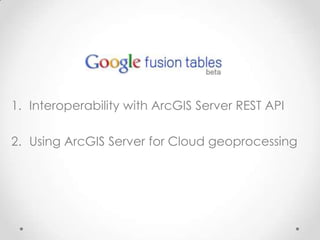
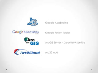
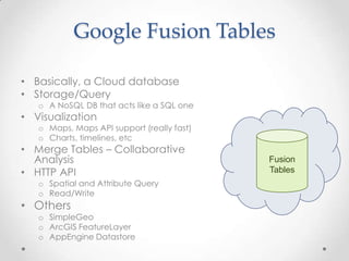
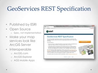
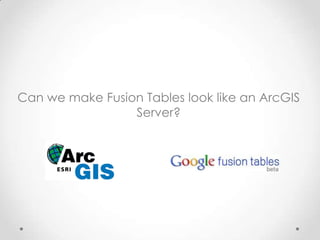
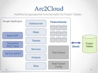
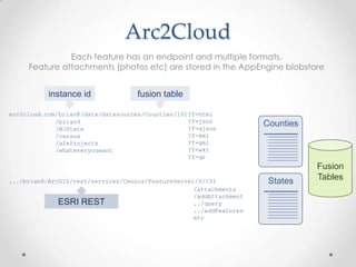
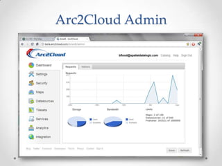
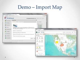
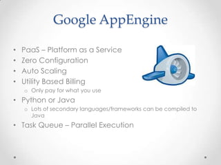
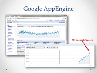
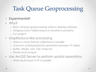
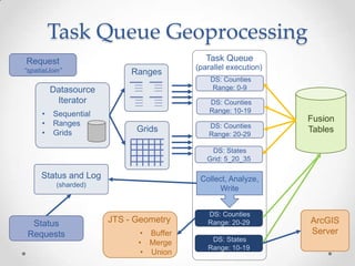
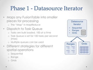
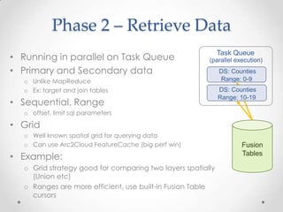
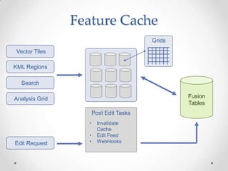
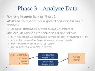
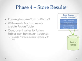
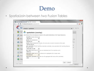
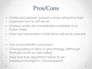
Using Google AppEngine and Fusion Tables with ArcGIS ServerBrian FloodArc2Earth
Interoperability with ArcGIS Server REST APIUsing ArcGIS Server for Cloud geoprocessing
Google AppEngineGoogle Fusion TablesArcGIS Server – Geometry ServiceArc2Cloud
Google Fusion TablesBasically, a Cloud databaseStorage/QueryA NoSQLDB that acts like a SQL oneVisualizationMaps, Maps API support (really fast)Charts, timelines, etcMerge Tables – Collaborative Analysis HTTP APISpatial and Attribute QueryRead/WriteOthersSimpleGeoArcGIS FeatureLayerAppEngineDatastoreFusion Tables
Fusion Tables - StorageSQL Syntax not quite but close enoughSELECT, GROUP BY, FiltersBBOX and Radius Search need to filter in userland for polylines/polygons“contains ignoring case” – poor man’s full text search Read/Write Inserts, Bulk Inserts, Updates, Deletes rowidas primary key, a little wonkyBigTable/Megastore backendHuge ScaleHilbert curve for spatial indexSpatial and attribute portions of query execute in parallel, results merged (“all data near NYC with four stars”)
Fusion Tables - VisualizationMapsDynamic Map Tiles – really fastGoogle Maps API supportCould be used from any client api that supports tilesRenderer StylesInfo Window templatesSimple HeatmapsTimelinesChartsTable View
Fusion Tables – Why?Instant ScalabilityZero ConfigurationZero MaintenancePremium Access from GoogleGoogle Infrastructure
GeoServices REST SpecificationPublished by ESRIOpen SourceSpec, not implementationMake your map services look like ArcGIS ServerInteroperable ArcGIS.comArcGIS ExplorerAGS Mobile Apps
Can we make Fusion Tables look like an ArcGIS Server?
Arc2CloudAdditional geospatial functionality for Fusion Tables Google AppEngineDatasourcesMapsFeatureCacheNative APIFusion TablesTilesetsGeospatial REST SpecOAuthServicesTask Queue WFS & WFS/TAnalysisMulti Tenant ConfigSites
Arc2CloudEach feature has an endpoint and multiple formats. Feature attachments (photos etc) are stored in the AppEngineblobstoreinstance idfusion tablearc2cloud.com/brian8/data/datasources/Counties/101?f=htmlCounties?f=json?f=gjson?f=kml?f=gml?f=wkt?f=qr/brian9/NJState/census/a2eProjects/whateveryouwantFusion TablesStates.../brian8/ArcGIS/rest/services/Census/FeatureServer/0/101/attachments/addAttachment../query../addFeaturesetcESRI REST
Arc2Cloud Admin
Demo – Import Map
Google AppEnginePaaS – Platform as a ServiceZero ConfigurationAuto ScalingUtility Based Billing Only pay for what you usePython or Java Lots of secondary languages/frameworks can be compiled to JavaTask Queue – Parallel Execution
Google AppEngine400 requests/second
How can we leverage AppEngine’s Task Queue with ArcGIS Server’s geoprocessing?
Task Queue GeoprocessingExperimental!Why?Basic full layer geoprocessing without desktop softwareMerging Fusion Tables based on location is powerfulFun projectMapReduce-like processingWork on many feature collections in parallelCommon overlay/proximity operations between FT TablesBuffer, Merge, Join, Clip, Snap etcDivide and conquerUse ArcGIS Server to perform spatial operations Write results back to FT in parallel
Prepare yourself for programmer artwork
Task Queue GeoprocessingTask QueueRequest“spatialJoin”(parallel execution)Ranges DS: CountiesRange: 0-9Datasource IteratorFusion Tables DS: CountiesRange: 10-19Sequential
Ranges
GridsGrids DS: CountiesRange: 20-29 DS: StatesGrid: 5_20_35Status and Log(sharded)Collect, Analyze, Write DS: CountiesRange: 20-29ArcGISServerJTS - GeometryStatusRequestsBuffer
Merge
Union DS: StatesRange: 10-19
Phase 1 - Datasource IteratorMaps any FusionTable into smaller pieces for processingThe “Map” in MapReduceDispatch to Task QueueTasks are bulk loaded, 100 at a timeTask Queue is set for 100 tasks per second (max)Multiple queues can be used Different strategies for different spatial operationsSequentialRangeGridsRangesDatasource IteratorGridsSequential
Ranges
GridsPhase 2 – Retrieve DataTask QueueRunning in parallel on Task QueuePrimary and Secondary dataUnlike MapReduceEx: target and join tablesSequential, Rangeoffset, limit sql parametersGridWell known spatial grid for querying dataCan use Arc2Cloud FeatureCache (big perf win)Example:Grid strategy good for comparing two layers spatially (Union etc)Ranges are more efficient, use built-in Fusion Table cursors(parallel execution)DS: CountiesRange: 0-9DS: CountiesRange: 10-19Fusion Tables
Feature CacheVector TilesKML RegionsGridsFusion TablesSearchAnalysis GridPost Edit TasksInvalidate Cache

Dev Summit 2011 - Talk

  • 1.
    Using Google AppEngineand Fusion Tables with ArcGIS ServerBrian FloodArc2Earth
  • 2.
    Interoperability with ArcGISServer REST APIUsing ArcGIS Server for Cloud geoprocessing
  • 3.
    Google AppEngineGoogle FusionTablesArcGIS Server – Geometry ServiceArc2Cloud
  • 4.
    Google Fusion TablesBasically,a Cloud databaseStorage/QueryA NoSQLDB that acts like a SQL oneVisualizationMaps, Maps API support (really fast)Charts, timelines, etcMerge Tables – Collaborative Analysis HTTP APISpatial and Attribute QueryRead/WriteOthersSimpleGeoArcGIS FeatureLayerAppEngineDatastoreFusion Tables
  • 5.
    Fusion Tables -StorageSQL Syntax not quite but close enoughSELECT, GROUP BY, FiltersBBOX and Radius Search need to filter in userland for polylines/polygons“contains ignoring case” – poor man’s full text search Read/Write Inserts, Bulk Inserts, Updates, Deletes rowidas primary key, a little wonkyBigTable/Megastore backendHuge ScaleHilbert curve for spatial indexSpatial and attribute portions of query execute in parallel, results merged (“all data near NYC with four stars”)
  • 6.
    Fusion Tables -VisualizationMapsDynamic Map Tiles – really fastGoogle Maps API supportCould be used from any client api that supports tilesRenderer StylesInfo Window templatesSimple HeatmapsTimelinesChartsTable View
  • 7.
    Fusion Tables –Why?Instant ScalabilityZero ConfigurationZero MaintenancePremium Access from GoogleGoogle Infrastructure
  • 8.
    GeoServices REST SpecificationPublishedby ESRIOpen SourceSpec, not implementationMake your map services look like ArcGIS ServerInteroperable ArcGIS.comArcGIS ExplorerAGS Mobile Apps
  • 9.
    Can we makeFusion Tables look like an ArcGIS Server?
  • 10.
    Arc2CloudAdditional geospatial functionalityfor Fusion Tables Google AppEngineDatasourcesMapsFeatureCacheNative APIFusion TablesTilesetsGeospatial REST SpecOAuthServicesTask Queue WFS & WFS/TAnalysisMulti Tenant ConfigSites
  • 11.
    Arc2CloudEach feature hasan endpoint and multiple formats. Feature attachments (photos etc) are stored in the AppEngineblobstoreinstance idfusion tablearc2cloud.com/brian8/data/datasources/Counties/101?f=htmlCounties?f=json?f=gjson?f=kml?f=gml?f=wkt?f=qr/brian9/NJState/census/a2eProjects/whateveryouwantFusion TablesStates.../brian8/ArcGIS/rest/services/Census/FeatureServer/0/101/attachments/addAttachment../query../addFeaturesetcESRI REST
  • 12.
  • 13.
  • 14.
    Google AppEnginePaaS –Platform as a ServiceZero ConfigurationAuto ScalingUtility Based Billing Only pay for what you usePython or Java Lots of secondary languages/frameworks can be compiled to JavaTask Queue – Parallel Execution
  • 15.
  • 16.
    How can weleverage AppEngine’s Task Queue with ArcGIS Server’s geoprocessing?
  • 17.
    Task Queue GeoprocessingExperimental!Why?Basicfull layer geoprocessing without desktop softwareMerging Fusion Tables based on location is powerfulFun projectMapReduce-like processingWork on many feature collections in parallelCommon overlay/proximity operations between FT TablesBuffer, Merge, Join, Clip, Snap etcDivide and conquerUse ArcGIS Server to perform spatial operations Write results back to FT in parallel
  • 18.
    Prepare yourself forprogrammer artwork
  • 19.
    Task Queue GeoprocessingTaskQueueRequest“spatialJoin”(parallel execution)Ranges DS: CountiesRange: 0-9Datasource IteratorFusion Tables DS: CountiesRange: 10-19Sequential
  • 20.
  • 21.
    GridsGrids DS: CountiesRange:20-29 DS: StatesGrid: 5_20_35Status and Log(sharded)Collect, Analyze, Write DS: CountiesRange: 20-29ArcGISServerJTS - GeometryStatusRequestsBuffer
  • 22.
  • 23.
  • 24.
    Phase 1 -Datasource IteratorMaps any FusionTable into smaller pieces for processingThe “Map” in MapReduceDispatch to Task QueueTasks are bulk loaded, 100 at a timeTask Queue is set for 100 tasks per second (max)Multiple queues can be used Different strategies for different spatial operationsSequentialRangeGridsRangesDatasource IteratorGridsSequential
  • 25.
  • 26.
    GridsPhase 2 –Retrieve DataTask QueueRunning in parallel on Task QueuePrimary and Secondary dataUnlike MapReduceEx: target and join tablesSequential, Rangeoffset, limit sql parametersGridWell known spatial grid for querying dataCan use Arc2Cloud FeatureCache (big perf win)Example:Grid strategy good for comparing two layers spatially (Union etc)Ranges are more efficient, use built-in Fusion Table cursors(parallel execution)DS: CountiesRange: 0-9DS: CountiesRange: 10-19Fusion Tables
  • 27.
    Feature CacheVector TilesKMLRegionsGridsFusion TablesSearchAnalysis GridPost Edit TasksInvalidate Cache