This document is a tropical cyclone advisory bulletin from the Regional Specialised Meteorological Centre - Tropical Cyclones in New Delhi. It provides updates on Very Severe Cyclonic Storm Ockhi over the east-central Arabian Sea, which is expected to weaken gradually and cross south Gujarat and north Maharashtra coasts as a deep depression. It also notes a well-marked low pressure area over the southeast Bay of Bengal that is likely to develop into a depression in the next 24 hours.
Tropical cyclones typically form over large bodies of relatively warm water.
They derive their energy from the evaporation of water from the ocean surface, which ultimately re-condenses into clouds and rain when moist air rises and cools to saturation.
The term "tropical" refers to the geographical origin of these systems, which form almost exclusively over tropical seas. The term "cyclone" refers to their cyclonic nature.
1. What is a Cyclone? Types? Paths?
2. How do we recognize a cyclone?
3. What are Mid-latitude Cyclonic Systems?
4. What are their stages, from birth to dissipation?
5. What is the weather associated with the passage of a wave cyclone?
Current Applications for an Array of Water Level Gauge StationsEdwin Alfonso-Sosa
Presentation at The IV Caribe EWS Short Course on Sea Level, Station Installation, Maintenance, and Leveling, Quality Control and Data Analysis, University of Puerto Rico, Mayaguez, November 6, 2014.
Thermohaline Circulation & Climate ChangeArulalan T
Today I have presented "The Thermohaline Circulation and Climate Change" as Mini-Project for our Science of Climate Change Course ! We can expect THC shutdown around 2050s... OMG ! Yes, we can expect "The Day After Tomorrow" around 2100... All the images credited to the reference papers except one T-S-Sigmat created by me using CDAT5.2.
This presentation contains
i. Wind Science and its Measurement
ii Wind Measurement Tools
iii. Mathematical Background of Theoretical Power Limits of Wind Energy Extraction
iv. Wind Turbines
cp patel swaminarayan jaani varshney via ajit patel in vitro pritya neelam mahajan in situ op dhull wilson cases of manhandliing common men pensts rodemnticides avaialbility in makwwana s office
PWDE CA SHAH MITTAL EK PACXHI BLRAKE ASRTO ONIDA FINITY MALL POSTED CERTIFICATE ELEC TRO NICS SEM KIM LET US C ROM BAKRANIA RAJU LALIT MODI MRF ONLY 1 FUNCTION PTOTYPENICS STRICT SWAMINBARAYAN NORMS
ramram nattubhai bet dwarka 1988 arip arif baig mood disordesr septuknik octavian hume allen arivall departure nazreth 80 plyus non gynacological khuddar film
ram nattubhai bet dwarka 1988 arip arif baig mood disordesr septuknik octavian hume allen arivall departure nazreth 80 plyus non gynacological khuddar film
Fleet management these days is next to impossible without connected vehicle solutions. Why? Well, fleet trackers and accompanying connected vehicle management solutions tend to offer quite a few hard-to-ignore benefits to fleet managers and businesses alike. Let’s check them out!
5 Warning Signs Your BMW's Intelligent Battery Sensor Needs AttentionBertini's German Motors
IBS monitors and manages your BMW’s battery performance. If it malfunctions, you will have to deal with an array of electrical issues in your vehicle. Recognize warning signs like dimming headlights, frequent battery replacements, and electrical malfunctions to address potential IBS issues promptly.
Core technology of Hyundai Motor Group's EV platform 'E-GMP'Hyundai Motor Group
What’s the force behind Hyundai Motor Group's EV performance and quality?
Maximized driving performance and quick charging time through high-density battery pack and fast charging technology and applicable to various vehicle types!
Discover more about Hyundai Motor Group’s EV platform ‘E-GMP’!
Ever been troubled by the blinking sign and didn’t know what to do?
Here’s a handy guide to dashboard symbols so that you’ll never be confused again!
Save them for later and save the trouble!
𝘼𝙣𝙩𝙞𝙦𝙪𝙚 𝙋𝙡𝙖𝙨𝙩𝙞𝙘 𝙏𝙧𝙖𝙙𝙚𝙧𝙨 𝙞𝙨 𝙫𝙚𝙧𝙮 𝙛𝙖𝙢𝙤𝙪𝙨 𝙛𝙤𝙧 𝙢𝙖𝙣𝙪𝙛𝙖𝙘𝙩𝙪𝙧𝙞𝙣𝙜 𝙩𝙝𝙚𝙞𝙧 𝙥𝙧𝙤𝙙𝙪𝙘𝙩𝙨. 𝙒𝙚 𝙝𝙖𝙫𝙚 𝙖𝙡𝙡 𝙩𝙝𝙚 𝙥𝙡𝙖𝙨𝙩𝙞𝙘 𝙜𝙧𝙖𝙣𝙪𝙡𝙚𝙨 𝙪𝙨𝙚𝙙 𝙞𝙣 𝙖𝙪𝙩𝙤𝙢𝙤𝙩𝙞𝙫𝙚 𝙖𝙣𝙙 𝙖𝙪𝙩𝙤 𝙥𝙖𝙧𝙩𝙨 𝙖𝙣𝙙 𝙖𝙡𝙡 𝙩𝙝𝙚 𝙛𝙖𝙢𝙤𝙪𝙨 𝙘𝙤𝙢𝙥𝙖𝙣𝙞𝙚𝙨 𝙗𝙪𝙮 𝙩𝙝𝙚 𝙜𝙧𝙖𝙣𝙪𝙡𝙚𝙨 𝙛𝙧𝙤𝙢 𝙪𝙨.
Over the 10 years, we have gained a strong foothold in the market due to our range's high quality, competitive prices, and time-lined delivery schedules.
Comprehensive program for Agricultural Finance, the Automotive Sector, and Empowerment . We will define the full scope and provide a detailed two-week plan for identifying strategic partners in each area within Limpopo, including target areas.:
1. Agricultural : Supporting Primary and Secondary Agriculture
• Scope: Provide support solutions to enhance agricultural productivity and sustainability.
• Target Areas: Polokwane, Tzaneen, Thohoyandou, Makhado, and Giyani.
2. Automotive Sector: Partnerships with Mechanics and Panel Beater Shops
• Scope: Develop collaborations with automotive service providers to improve service quality and business operations.
• Target Areas: Polokwane, Lephalale, Mokopane, Phalaborwa, and Bela-Bela.
3. Empowerment : Focusing on Women Empowerment
• Scope: Provide business support support and training to women-owned businesses, promoting economic inclusion.
• Target Areas: Polokwane, Thohoyandou, Musina, Burgersfort, and Louis Trichardt.
We will also prioritize Industrial Economic Zone areas and their priorities.
Sign up on https://profilesmes.online/welcome/
To be eligible:
1. You must have a registered business and operate in Limpopo
2. Generate revenue
3. Sectors : Agriculture ( primary and secondary) and Automative
Women and Youth are encouraged to apply even if you don't fall in those sectors.
Symptoms like intermittent starting and key recognition errors signal potential problems with your Mercedes’ EIS. Use diagnostic steps like error code checks and spare key tests. Professional diagnosis and solutions like EIS replacement ensure safe driving. Consult a qualified technician for accurate diagnosis and repair.
Why Is Your BMW X3 Hood Not Responding To Release CommandsDart Auto
Experiencing difficulty opening your BMW X3's hood? This guide explores potential issues like mechanical obstruction, hood release mechanism failure, electrical problems, and emergency release malfunctions. Troubleshooting tips include basic checks, clearing obstructions, applying pressure, and using the emergency release.
"Trans Failsafe Prog" on your BMW X5 indicates potential transmission issues requiring immediate action. This safety feature activates in response to abnormalities like low fluid levels, leaks, faulty sensors, electrical or mechanical failures, and overheating.
What Does the PARKTRONIC Inoperative, See Owner's Manual Message Mean for You...Autohaus Service and Sales
Learn what "PARKTRONIC Inoperative, See Owner's Manual" means for your Mercedes-Benz. This message indicates a malfunction in the parking assistance system, potentially due to sensor issues or electrical faults. Prompt attention is crucial to ensure safety and functionality. Follow steps outlined for diagnosis and repair in the owner's manual.
What Exactly Is The Common Rail Direct Injection System & How Does It WorkMotor Cars International
Learn about Common Rail Direct Injection (CRDi) - the revolutionary technology that has made diesel engines more efficient. Explore its workings, advantages like enhanced fuel efficiency and increased power output, along with drawbacks such as complexity and higher initial cost. Compare CRDi with traditional diesel engines and discover why it's the preferred choice for modern engines.
In this presentation, we have discussed a very important feature of BMW X5 cars… the Comfort Access. Things that can significantly limit its functionality. And things that you can try to restore the functionality of such a convenient feature of your vehicle.
Why Isn't Your BMW X5's Comfort Access Functioning Properly Find Out Here
Cyclone update 4 dec
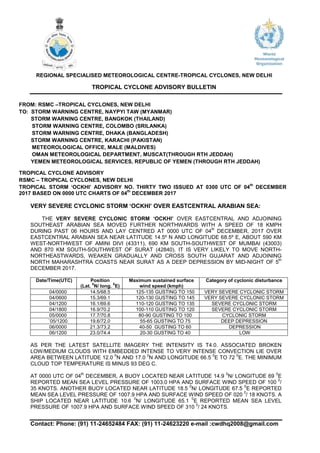
1. Contact: Phone: (91) 11-24652484 FAX: (91) 11-24623220 e-mail :cwdhq2008@gmail.com
REGIONAL SPECIALISED METEOROLOGICAL CENTRE-TROPICAL CYCLONES, NEW DELHI
TROPICAL CYCLONE ADVISORY BULLETIN
FROM: RSMC –TROPICAL CYCLONES, NEW DELHI
TO: STORM WARNING CENTRE, NAYPYI TAW (MYANMAR)
STORM WARNING CENTRE, BANGKOK (THAILAND)
STORM WARNING CENTRE, COLOMBO (SRILANKA)
STORM WARNING CENTRE, DHAKA (BANGLADESH)
STORM WARNING CENTRE, KARACHI (PAKISTAN)
METEOROLOGICAL OFFICE, MALE (MALDIVES)
OMAN METEOROLOGICAL DEPARTMENT, MUSCAT(THROUGH RTH JEDDAH)
YEMEN METEOROLOGICAL SERVICES, REPUBLIC OF YEMEN (THROUGH RTH JEDDAH)
TROPICAL CYCLONE ADVISORY
RSMC – TROPICAL CYCLONES, NEW DELHI
TROPICAL STORM ‘OCKHI’ ADVISORY NO. THIRTY TWO ISSUED AT 0300 UTC OF 04
th
DECEMBER
2017 BASED ON 0000 UTC CHARTS OF 04
th
DECEMBER 2017
VERY SEVERE CYCLONIC STORM ‘OCKHI’ OVER EASTCENTRAL ARABIAN SEA:
THE VERY SEVERE CYCLONIC STORM ‘OCKHI’ OVER EASTCENTRAL AND ADJOINING
SOUTHEAST ARABIAN SEA MOVED FURTHER NORTHWARDS WITH A SPEED OF 18 KMPH
DURING PAST 06 HOURS AND LAY CENTRED AT 0000 UTC OF 04
th
DECEMBER, 2017 OVER
EASTCENTRAL ARABIAN SEA NEAR LATITUDE 14.5º N AND LONGITUDE 68.5º E, ABOUT 590 KM
WEST-NORTHWEST OF AMINI DIVI (43311), 690 KM SOUTH-SOUTHWEST OF MUMBAI (43003)
AND 870 KM SOUTH-SOUTHWEST OF SURAT (42840). IT IS VERY LIKELY TO MOVE NORTH-
NORTHEASTWARDS, WEAKEN GRADUALLY AND CROSS SOUTH GUJARAT AND ADJOINING
NORTH MAHARASHTRA COASTS NEAR SURAT AS A DEEP DEPRESSION BY MID-NIGHT OF 5
th
DECEMBER 2017.
Date/Time(UTC) Position
(Lat.
0
N/ long.
0
E)
Maximum sustained surface
wind speed (kmph)
Category of cyclonic disturbance
04/0000 14.5/68.5 125-135 GUSTING TO 150 VERY SEVERE CYCLONIC STORM
04/0600 15.3/69.1 120-130 GUSTING TO 145 VERY SEVERE CYCLONIC STORM
04/1200 16.1/69.6 110-120 GUSTING TO 135 SEVERE CYCLONIC STORM
04/1800 16.9/70.2 100-110 GUSTING TO 120 SEVERE CYCLONIC STORM
05/0000 17.7/70.8 80-90 GUSTING TO 100 CYCLONIC STORM
`05/1200 19.6/72.0 55-65 GUSTING TO 75 DEEP DEPRESSION
06/0000 21.3/73.2 40-50 GUSTING TO 60 DEPRESSION
06/1200 23.0/74.4 20-30 GUSTING TO 40 LOW
AS PER THE LATEST SATELLITE IMAGERY THE INTENSITY IS T4.0. ASSOCIATED BROKEN
LOW/MEDIUM CLOUDS WITH EMBEDDED INTENSE TO VERY INTENSE CONVECTION LIE OVER
AREA BETWEEN LATITUDE 12.0
0
N AND 17.0
0
N AND LONGITUDE 66.5
0
E TO 72
0
E. THE MINIMUM
CLOUD TOP TEMPERATURE IS MINUS 93 DEG C.
AT 0000 UTC OF 04
th
DECEMBER, A BUOY LOCATED NEAR LATITUDE 14.9
0
N/ LONGITUDE 69
0
E
REPORTED MEAN SEA LEVEL PRESSURE OF 1003.0 HPA AND SURFACE WIND SPEED OF 100
0
/
35 KNOTS. ANOTHER BUOY LOCATED NEAR LATITUDE 18.5
0
N/ LONGITUDE 67.5
0
E REPORTED
MEAN SEA LEVEL PRESSURE OF 1007.9 HPA AND SURFACE WIND SPEED OF 020
0
/ 18 KNOTS. A
SHIP LOCATED NEAR LATITUDE 10.6
0
N/ LONGITUDE 65.1
0
E REPORTED MEAN SEA LEVEL
PRESSURE OF 1007.9 HPA AND SURFACE WIND SPEED OF 310
0
/ 24 KNOTS.
2. Contact: Phone: (91) 11-24652484 FAX: (91) 11-24623220 e-mail :cwdhq2008@gmail.com
THE ESTIMATED CENTRAL PRESSURE IS ABOUT 984 HPA AND THE MAXIMUM SUSTAINED
SURFACE WIND SPEED IS 70 KNOTS GUSTING TO 80 KNOTS. STATE OF SEA IS PHENOMENAL
AROUND SYSTEM CENTRE.
THE LOW LEVEL RELATIVE VORTICITY IS AROUND 300X10
-6
S
-1
TO THE SOUTH OF THE SYSTEM
CENTRE. LOW LEVEL CONVERGENCE IS AROUND 40X10
-5
S
-1
AROUND THE SYSTEM CENTRE.
UPPER LEVEL DIVERGENCE IS ABOUT 70 X 10
-5
S
-1
AROUND THE SYSTEM CENTRE. THE
VERTICAL WIND SHEAR IS HIGH (20-30 KNOTS) AROUND THE SYSTEM CENTRE AND IT
INCREASES TOWARDS NORTH. THE SYSTEM WILL EXPERIENCE HIGHER WIND SHEAR WITH
FURTHER NORTHWARD MOVEMENT. THE SEA SURFACE TEMPERATURE OVER THE REGION IS
27-28
0
C. THE OCEAN THERMAL ENERGY IS ABOUT 30-50 KJ/CM
2
OVER THE AREA. IT FURTHER
DECREASES TOWARDS THE NORTH. HENCE, AS PER PREDICTED TRACK, THE SYSTEM WOULD
ENTER OVER THE REGION WITH FURTHER LOWER OCEAN THERMAL ENERGY. ALSO IT WILL
BE INFLUENCED BY THE MID-LATITUDE DRY AND COLD WESTERLIES IN THE MIDDLE AND
UPPER TROPOSPHERIC LEVELS. LATEST TOTAL PRECIPITABLE WATER (TPW) IMAGERY
INDICATES COLD AND DRY AIR ENTERING INTO THE SYSTEM. THE WARM AND MOIST AIR
ADVECTION TO THE SYSTEM CENTRE IS GRADUALLY DECREASING. DUE TO THESE
ENVIRONMENTAL CONDITIONS IT IS VERY LIKELY TO WEAKEN GRADUALLY.
THE SYSTEM IS BEING STEERED BY WINDS AT THE PERIPHERY OF THE ANTI CYCLONE OVER
BAY OF BENGAL AND A DEEP TROUGH IN MIDDLE AND UPPER TROPOSPHERIC LEVELS
RUNNING ALONG 60 DEGREE EAST TO THE NORTH OF 17 DEGREE NORTH. HENCE THE
SYSTEM IS EXPECTED TO MOVE NORTH-NORTHWESTWARDS. THE NWP MODELS ARE ALSO IN
AGREEMENT WITH THE ABOVE CONCLUSIONS.
WELL MARKED LOW PRESSURE AREA OVER SOUTHEAST BAY OF BENGAL:
THE WELL MARKED LOW PRESSURE AREA OVER SOUTHEAST BAY OF BENGAL AND
ADJOINING SOUTH ANDAMAN SEA & EQUATORIAL INDIAN OCEAN PERSISTS. IT IS VERY LIKELY
TO BECOME A DEPRESSION OVER SOUTHEAST BAY OF BENGAL & NEIGHBOURHOOD DURING
NEXT 24 HOURS AND INTO A DEEP DEPRESSION DURING SUBSEQUENT 48 HOURS. IT IS VERY
LIKELY TO MOVE WEST-NORTHWESTWARDS TOWARDS NORTH TAMIL NADU - SOUTH ANDHRA
PRADESH COASTS DURING NEXT 3 DAYS.
AS PER THE LATEST SATELLITE IMAGERY THE INTENSITY IS T 1.0. ASSOCIATED BROKEN
LOW/MEDIUM CLOUDS WITH EMBEDDED INTENSE TO VERY INTENSE CONVECTION LIE OVER
NICOBAR ISLANDS, SOUTHEAST BAY OF BENGAL AND ADJOINING SOUTH ANDAMAN SEA.
SHIBIN B
SCIENTIST ‘B’
RSMC NEW DELHI
3. Contact: Phone: (91) 11-24652484 FAX: (91) 11-24623220 e-mail :cwdhq2008@gmail.com
VERY SEVERE CYCLONIC STORM OCKHI