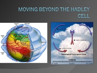
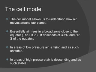
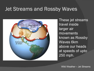
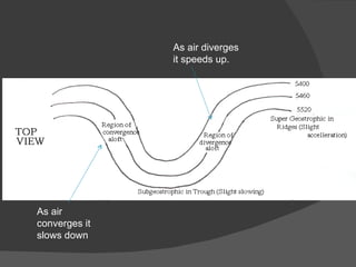
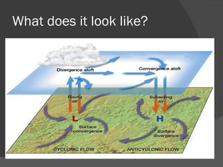
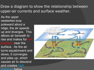
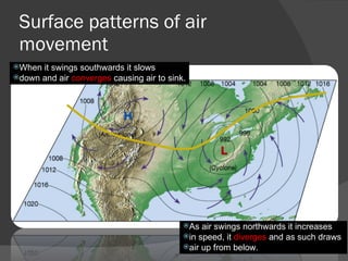
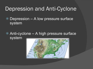
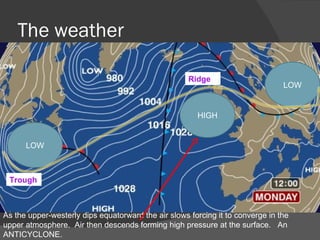
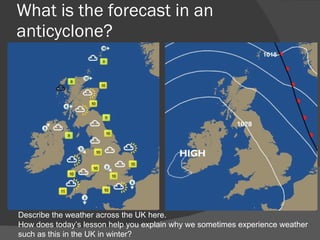
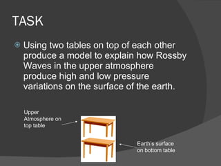
The cell model The cell model allows us to understand how air moves around our planet. Essentially air rises in a broad zone close to the equator (The ITCZ).  It descends at 30 o  N and 30 o  S of the equator. In areas of low pressure air is rising and as such unstable. In areas of high pressure air is descending and as such stable.
The weather
Questions You could ask If this cell model is true and air is generally ascending above the UK (low pressure) why don’t we get low pressure all year round. If the cell model is true everywhere around the 60 o   N or S of the equator should have low pressure all year round.
Lesson Aim To understand how movements in the upper atmosphere affect surface weather. By the end of the lesson you will be able to explain a model of why we get variations in pressure on the earth’s surface.
 
Jet Streams and Rossby Waves These jet streams travel inside larger air movements known as Rossby Waves 6km above our heads at speeds of upto 250 mph. Wild Weather – Jet Streams
 
Upper atmosphere air movements The movement of a jet stream is broadly similar to a river. Eg it meanders. As it meanders it slows down and speeds up just like a river does. As air swings northwards it increases in speed, it  diverges  and as such draws air up from below. When it swings southwards it slows down and air  converges  causing air to sink.
As air converges it slows down As air diverges it speeds up.
The Polar Front Jet Stream Varies between 40 – 60 degrees North of the equator and is the dividing line between the Polar and Ferrel Cells.  When it descends south it brings cold air which descends in a clockwise direction bringing stable conditions. (Anticyclone) When it moves north it sucks up warm air in an anticlockwise direction. (Depression)
The Polar Front Jet Stream It usually tracks North East across the UK bringing our frequent wet and windy weather. When the path changes we get our extremes of climate such as the summer of 2006. (It hardly rained for 2 months)
What does it look like?
Draw a diagram to show the relationship between upper-air currents and surface weather. As the upper westerlies loop poleward about a ridge, the air speeds up and diverges.  This allows air beneath to rise and makes for  low pressure  near the surface.  As the air turns equatorward and slows, it converges and piles up, which causes air to descend and creates  high pressure  below.
Surface patterns of air movement When it swings southwards it slows  down and air  converges  causing air to sink. As air swings northwards it increases  in speed, it  diverges  and as such draws  air up from below.
Depression and Anti-Cyclone Depression – A low pressure surface system Anti-cyclone – A high pressure surface system
The weather LOW HIGH As the upper-westerly dips equatorward the air slows forcing it to converge in the upper atmosphere.  Air then descends forming high pressure at the surface.  An ANTICYCLONE. Trough Ridge LOW
What is the forecast in an anticyclone? Describe the weather across the UK here. How does today’s lesson help you explain why we sometimes experience weather such as this in the UK in winter?
TASK Using two tables on top of each other produce a model to explain how Rossby Waves in the upper atmosphere produce high and low pressure variations on the surface of the earth. Upper Atmosphere on top table Earth’s surface on bottom table
Questions Explain how upper-air movements can cause an area of low pressure over the United Kingdom?

Upper atmosphere air movements

  • 1.
  • 2.
    The cell modelThe cell model allows us to understand how air moves around our planet. Essentially air rises in a broad zone close to the equator (The ITCZ). It descends at 30 o N and 30 o S of the equator. In areas of low pressure air is rising and as such unstable. In areas of high pressure air is descending and as such stable.
  • 3.
  • 4.
    Questions You couldask If this cell model is true and air is generally ascending above the UK (low pressure) why don’t we get low pressure all year round. If the cell model is true everywhere around the 60 o N or S of the equator should have low pressure all year round.
  • 5.
    Lesson Aim Tounderstand how movements in the upper atmosphere affect surface weather. By the end of the lesson you will be able to explain a model of why we get variations in pressure on the earth’s surface.
  • 6.
  • 7.
    Jet Streams andRossby Waves These jet streams travel inside larger air movements known as Rossby Waves 6km above our heads at speeds of upto 250 mph. Wild Weather – Jet Streams
  • 8.
  • 9.
    Upper atmosphere airmovements The movement of a jet stream is broadly similar to a river. Eg it meanders. As it meanders it slows down and speeds up just like a river does. As air swings northwards it increases in speed, it diverges and as such draws air up from below. When it swings southwards it slows down and air converges causing air to sink.
  • 10.
    As air convergesit slows down As air diverges it speeds up.
  • 11.
    The Polar FrontJet Stream Varies between 40 – 60 degrees North of the equator and is the dividing line between the Polar and Ferrel Cells. When it descends south it brings cold air which descends in a clockwise direction bringing stable conditions. (Anticyclone) When it moves north it sucks up warm air in an anticlockwise direction. (Depression)
  • 12.
    The Polar FrontJet Stream It usually tracks North East across the UK bringing our frequent wet and windy weather. When the path changes we get our extremes of climate such as the summer of 2006. (It hardly rained for 2 months)
  • 13.
    What does itlook like?
  • 14.
    Draw a diagramto show the relationship between upper-air currents and surface weather. As the upper westerlies loop poleward about a ridge, the air speeds up and diverges. This allows air beneath to rise and makes for low pressure near the surface. As the air turns equatorward and slows, it converges and piles up, which causes air to descend and creates high pressure below.
  • 15.
    Surface patterns ofair movement When it swings southwards it slows down and air converges causing air to sink. As air swings northwards it increases in speed, it diverges and as such draws air up from below.
  • 16.
    Depression and Anti-CycloneDepression – A low pressure surface system Anti-cyclone – A high pressure surface system
  • 17.
    The weather LOWHIGH As the upper-westerly dips equatorward the air slows forcing it to converge in the upper atmosphere. Air then descends forming high pressure at the surface. An ANTICYCLONE. Trough Ridge LOW
  • 18.
    What is theforecast in an anticyclone? Describe the weather across the UK here. How does today’s lesson help you explain why we sometimes experience weather such as this in the UK in winter?
  • 19.
    TASK Using twotables on top of each other produce a model to explain how Rossby Waves in the upper atmosphere produce high and low pressure variations on the surface of the earth. Upper Atmosphere on top table Earth’s surface on bottom table
  • 20.
    Questions Explain howupper-air movements can cause an area of low pressure over the United Kingdom?