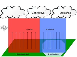
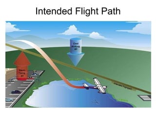
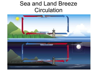
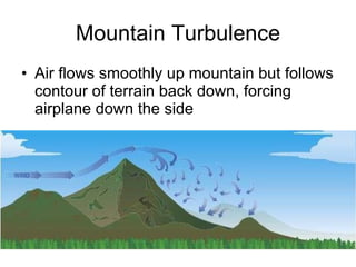
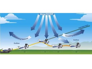
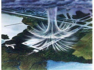
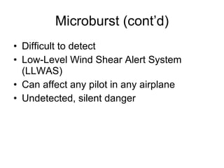
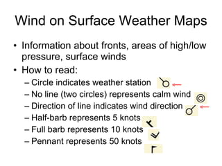
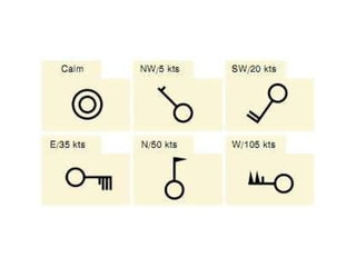
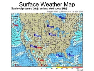
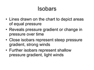
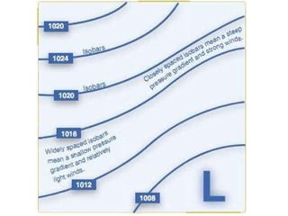
Weather Theory Part II: Air Movement Group C: Second Year PHAK Chapter 11, pages 7-12
Recall Air  always  strives to achieve _________ due to unequal _______ of Earth’s surface Atmosphere is 78% ________, __% oxygen, and 1% other gases Warm air is ____ (____ dense), thus rises while cool air is _____ (____ dense), thus sinks ____________ deflects air to the ____ in the Northern Hemisphere Air is measured in inches of ________ Pressure and temperature ________ as altitude ________ Lower pressure causes longer takeoff roll Lower oxygen concentration at higher _______ can/will cause _______ thin less thick hypoxia more equilibrium heating nitrogen 21 Coriolis effect right mercury decrease increases altitudes
Essential Questions What is the difference between wind and currents? What is the difference between cyclonic and anti-cyclonic circulation? What effects do surfaces have that retain heat?  Release heat? What is low-level wind shear and what sorts of hazards does it present? How can wind and pressure be depicted on a surface weather map?
Wind and Currents Air always strives equilibrium – air moves from high pressure to low pressure Currents – vertical movement of air Wind – horizontal movement of air
Wind Patterns Vertical movements – currents Horizontal movements – winds Anti-cyclonic circulation is clockwise movement of air around an area of high pressure Cyclonic circulation is counterclockwise movement of air around an area of low pressure High pressure: Dry, stable, descending Good weather   Low pressure: Unstable, cloudiness and precipitation Bad weather   Favorable winds Large-scale only; doesn’t account for local conditions, geographical abnormalities, etc.
Favorable Winds
Convective Currents Releases heat: Plowed ground Rocks Sand Retains heat: Water Trees Convective currents cause turbulent air when flying low, in warm weather, or over varying surfaces
Releases heat Retains heat updraft downdraft Convective Turbulence
Intended Flight Path
Sea and Land Breeze Circulation
Mountain Turbulence Air flows smoothly up mountain but follows contour of terrain back down, forcing airplane down the side
Low-Level Wind Shear Sudden, drastic change in wind speed and/or direction over a very small area Violent updrafts and downdrafts Abrupt changes to horizontal movement of aircraft Hazardous due to close proximity of aircraft close to ground Directional wind changes of 180 and speed changes of 50+ knots associated
Low-Level Wind Shear (cont’d) Rapid changes in wind direction and velocity change the wind’s relation to the aircraft, disrupting the normal flight attitude and performance of the aircraft Most severe type associated with convective precipitation or rain from thunderstorms
Microburst Type of low-level wind shear Associated with convective precipiration Normally >1 mile horizontal & ≥1,000 feet vertically and lasts 15 minutes, during which can produce downdrafts of up to 6,000 fpm Microburst behavior: 1. performance-increasing headwind 2. performance-decreasing downdraft 3. rapid tailwind shear 4. can result in terrain impact or flight dangerously close to the ground
 
 
Microburst (cont’d) Difficult to detect Low-Level Wind Shear Alert System (LLWAS) Can affect any pilot in any airplane Undetected, silent danger
Wind on Surface Weather Maps Information about fronts, areas of high/low pressure, surface winds How to read: Circle indicates weather station No line (two circles) represents calm wind Direction of line indicates wind direction Half-barb represents 5 knots Full barb represents 10 knots Pennant represents 50 knots
 
Surface Weather Map
Isobars Lines drawn on the chart to depict areas of equal pressure Reveals pressure gradient or change in pressure over time Close isobars represent steep pressure gradient, strong winds Further isobars represent shallow pressure gradient, light winds
 

Weather Theory Part II (Group C)

  • 1.
    Weather Theory PartII: Air Movement Group C: Second Year PHAK Chapter 11, pages 7-12
  • 2.
    Recall Air always strives to achieve _________ due to unequal _______ of Earth’s surface Atmosphere is 78% ________, __% oxygen, and 1% other gases Warm air is ____ (____ dense), thus rises while cool air is _____ (____ dense), thus sinks ____________ deflects air to the ____ in the Northern Hemisphere Air is measured in inches of ________ Pressure and temperature ________ as altitude ________ Lower pressure causes longer takeoff roll Lower oxygen concentration at higher _______ can/will cause _______ thin less thick hypoxia more equilibrium heating nitrogen 21 Coriolis effect right mercury decrease increases altitudes
  • 3.
    Essential Questions Whatis the difference between wind and currents? What is the difference between cyclonic and anti-cyclonic circulation? What effects do surfaces have that retain heat? Release heat? What is low-level wind shear and what sorts of hazards does it present? How can wind and pressure be depicted on a surface weather map?
  • 4.
    Wind and CurrentsAir always strives equilibrium – air moves from high pressure to low pressure Currents – vertical movement of air Wind – horizontal movement of air
  • 5.
    Wind Patterns Verticalmovements – currents Horizontal movements – winds Anti-cyclonic circulation is clockwise movement of air around an area of high pressure Cyclonic circulation is counterclockwise movement of air around an area of low pressure High pressure: Dry, stable, descending Good weather  Low pressure: Unstable, cloudiness and precipitation Bad weather  Favorable winds Large-scale only; doesn’t account for local conditions, geographical abnormalities, etc.
  • 6.
  • 7.
    Convective Currents Releasesheat: Plowed ground Rocks Sand Retains heat: Water Trees Convective currents cause turbulent air when flying low, in warm weather, or over varying surfaces
  • 8.
    Releases heat Retainsheat updraft downdraft Convective Turbulence
  • 9.
  • 10.
    Sea and LandBreeze Circulation
  • 11.
    Mountain Turbulence Airflows smoothly up mountain but follows contour of terrain back down, forcing airplane down the side
  • 12.
    Low-Level Wind ShearSudden, drastic change in wind speed and/or direction over a very small area Violent updrafts and downdrafts Abrupt changes to horizontal movement of aircraft Hazardous due to close proximity of aircraft close to ground Directional wind changes of 180 and speed changes of 50+ knots associated
  • 13.
    Low-Level Wind Shear(cont’d) Rapid changes in wind direction and velocity change the wind’s relation to the aircraft, disrupting the normal flight attitude and performance of the aircraft Most severe type associated with convective precipitation or rain from thunderstorms
  • 14.
    Microburst Type oflow-level wind shear Associated with convective precipiration Normally >1 mile horizontal & ≥1,000 feet vertically and lasts 15 minutes, during which can produce downdrafts of up to 6,000 fpm Microburst behavior: 1. performance-increasing headwind 2. performance-decreasing downdraft 3. rapid tailwind shear 4. can result in terrain impact or flight dangerously close to the ground
  • 15.
  • 16.
  • 17.
    Microburst (cont’d) Difficultto detect Low-Level Wind Shear Alert System (LLWAS) Can affect any pilot in any airplane Undetected, silent danger
  • 18.
    Wind on SurfaceWeather Maps Information about fronts, areas of high/low pressure, surface winds How to read: Circle indicates weather station No line (two circles) represents calm wind Direction of line indicates wind direction Half-barb represents 5 knots Full barb represents 10 knots Pennant represents 50 knots
  • 19.
  • 20.
  • 21.
    Isobars Lines drawnon the chart to depict areas of equal pressure Reveals pressure gradient or change in pressure over time Close isobars represent steep pressure gradient, strong winds Further isobars represent shallow pressure gradient, light winds
  • 22.