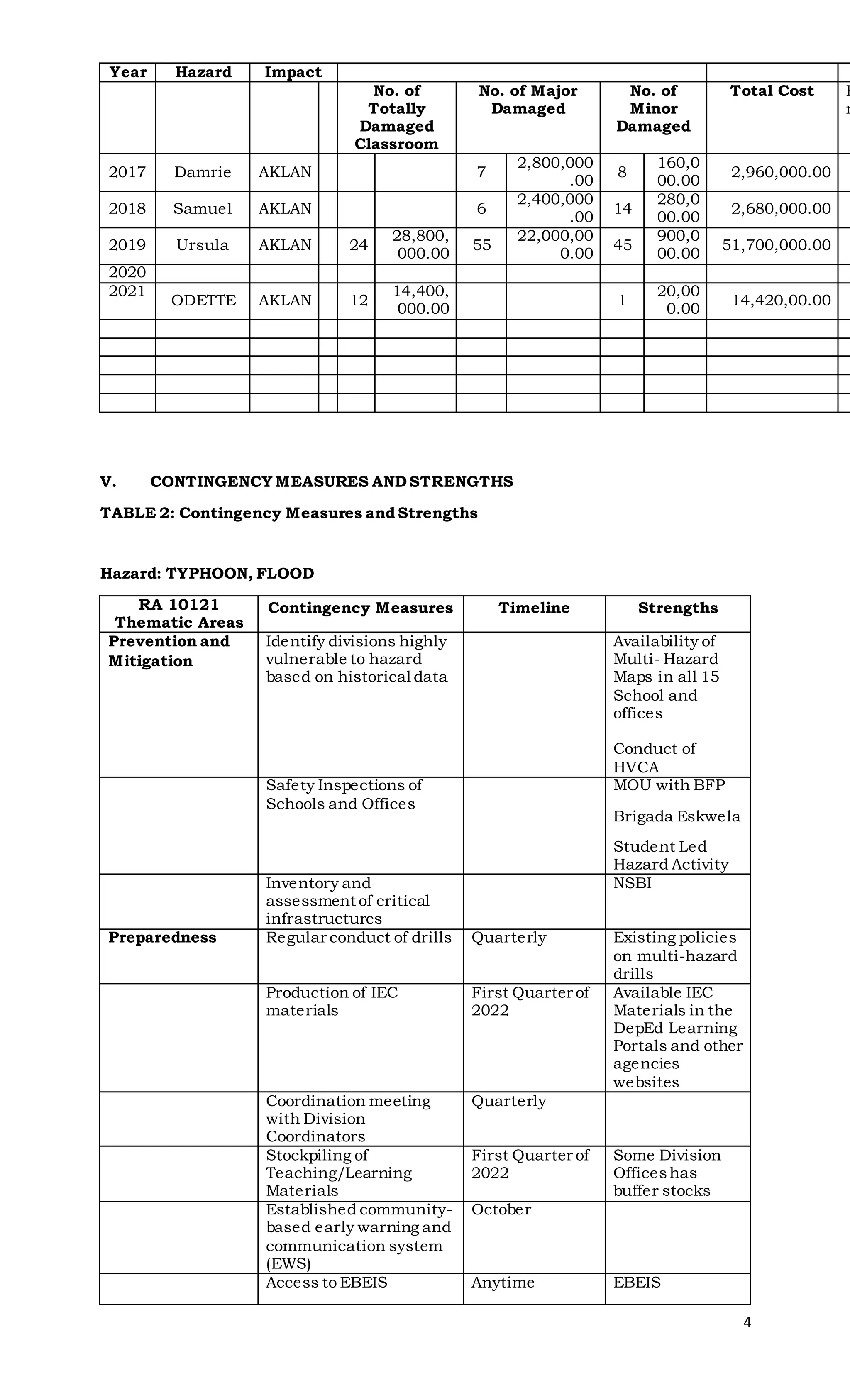
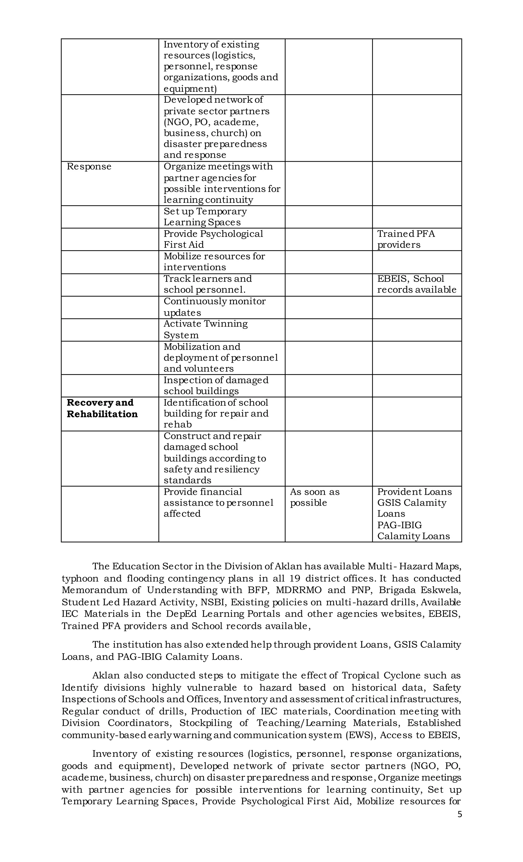
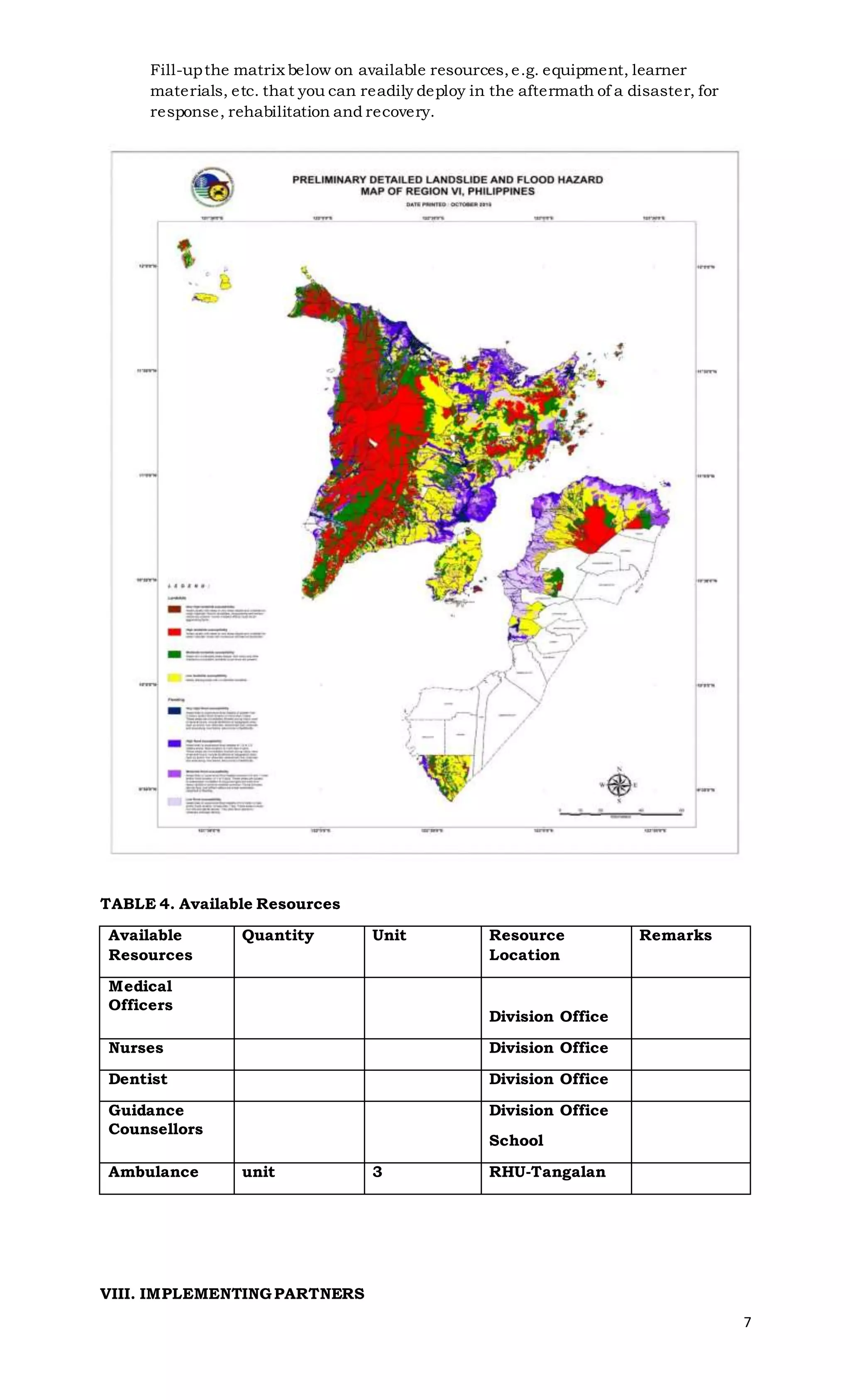
This document outlines the contingency plan for typhoons and flooding in the Tangalan district of Aklan province in the Philippines. It provides background on the hazards faced and disasters experienced in the area. Gaps in preparedness are identified, such as limited hazard mapping and lack of access to early warning systems. Contingency measures currently in place are described, including hazard maps, drills, emergency supplies, and coordination with partners like local government and NGOs. Implementing partners that provide support are listed. Preparedness actions are detailed for different stages of a typhoon, such as meetings, advisories, and assessments. Measures to address gaps are proposed, such as trainings, reiterating hazard activities, and developing memor
A draft of Contingency plan about Typhoon in line with the Office of Civil Defence standard in worst case scenario at school. This is in accordance to the Disaster Risk Reduction and Management plan of school.
It is a dangerous thing. How we can manage disaster. In India there is so much Disaster. It helps us to Disaster Management. It is Important to take care.
In light of Typhoon Haiyan and its impact on Philippines, the Yale-Tulane ESF-8 Planning and Response Program has produced this special report. The group that produced this summary and analysis of the current situation are graduate students from Yale and Tulane Universities.
It was compiled entirely from open source materials. Please feel free to forward the report to anyone who might be interested. Finally, for those of you who are deployed and responding to the crisis - if you need us to research a specific item/area for you let us know and we will do our best.
A Review of Water Management and Disaster Risk Reduction (DRR) in Lower Middl...Declan Hearne
This paper will focus on a review of the challenges and opportunities for Water Manage-ment and Disaster Risk Reduction in post disaster environments in lower middle Income Countries . The review will draw on grass roots experience from both Indonesia and Philippines.
The paper will outline the cost effectiveness of proactive strategies that consider disaster risk reduction as an integrated component of water management (as strongly indicated in AusAID policy for DRR.)
From Indonesia the reviewed will focus on how SurfAid International has cut into a niche corporate sector to attract funds to support social and environmental services in post dis-aster environments. The paper will look at three programs implemented in parallel by SurfAid International building health wellbeing and self-reliance of remote island communi-ties. Efforts from IWRM projects in Davao will also be consider and how they have pro-duced unintended, but welcome, outcomes in build the resilience of upland communities. Opportunities for better integration between water management and DRR will then be pre-sented.
The Symposium main theme which aims "to identify business opportunities for water sec-tor to integrate into an expanding environmental services industries" will be tackled by looking at the challenges in funding and sustaining funding for water management in post disaster environments. We will review the increasing role of the philanthropy in supporting recovery from disasters and the need to shift from responsive to proactive strategies for disaster management. The paper will present how water management and DRR strategies are both compatible and necessary to enable sustainable development, particularly in dis-aster prone SE Asia.
Finally the paper will apply these lessons and project a vision of how HELP Basins could become a local catalyst, creating a demand for water knowledge services that guides wa-ter actors to be proactive in engage a full spectrum of stakeholders for a truly diversified water business environment that is focus on social, economic and environment outcomes.
In light of Typhoon Haiyan and its impact on Philippines, the Yale-Tulane ESF-8 Planning and Response Program has produced this special report. The group that produced this summary and analysis of the current situation are graduate students from Yale and Tulane Universities. It was compiled entirely from open source materials. Please feel free to forward the report to anyone who might be interested. Finally, for those of you who are deployed and responding to the crisis - if you need us to research a specific item/area for you let us know and we will do our best.
Students of Motilal Nehru Public School, India have done research on water crisis, sources of water, water pollution, govt policies on control of water pollution etc. of Sri Uganda
Presentation of Mr. Emmanuel M. De Guzman, Commissioner of the Climate Change Commission during the Orientation Meeting with State Universities and Colleges on Local Climate Change Action Plans held on 16 March 2017 at the Senate of the Philippines.
http://lorenlegarda.com.ph/
http://climate.gov.ph/
Natural farming @ Dr. Siddhartha S. Jena.pptxsidjena70
A brief about organic farming/ Natural farming/ Zero budget natural farming/ Subash Palekar Natural farming which keeps us and environment safe and healthy. Next gen Agricultural practices of chemical free farming.
UNDERSTANDING WHAT GREEN WASHING IS!.pdfJulietMogola
Many companies today use green washing to lure the public into thinking they are conserving the environment but in real sense they are doing more harm. There have been such several cases from very big companies here in Kenya and also globally. This ranges from various sectors from manufacturing and goes to consumer products. Educating people on greenwashing will enable people to make better choices based on their analysis and not on what they see on marketing sites.
Willie Nelson Net Worth: A Journey Through Music, Movies, and Business Venturesgreendigital
Willie Nelson is a name that resonates within the world of music and entertainment. Known for his unique voice, and masterful guitar skills. and an extraordinary career spanning several decades. Nelson has become a legend in the country music scene. But, his influence extends far beyond the realm of music. with ventures in acting, writing, activism, and business. This comprehensive article delves into Willie Nelson net worth. exploring the various facets of his career that have contributed to his large fortune.
Follow us on: Pinterest
Introduction
Willie Nelson net worth is a testament to his enduring influence and success in many fields. Born on April 29, 1933, in Abbott, Texas. Nelson's journey from a humble beginning to becoming one of the most iconic figures in American music is nothing short of inspirational. His net worth, which estimated to be around $25 million as of 2024. reflects a career that is as diverse as it is prolific.
Early Life and Musical Beginnings
Humble Origins
Willie Hugh Nelson was born during the Great Depression. a time of significant economic hardship in the United States. Raised by his grandparents. Nelson found solace and inspiration in music from an early age. His grandmother taught him to play the guitar. setting the stage for what would become an illustrious career.
First Steps in Music
Nelson's initial foray into the music industry was fraught with challenges. He moved to Nashville, Tennessee, to pursue his dreams, but success did not come . Working as a songwriter, Nelson penned hits for other artists. which helped him gain a foothold in the competitive music scene. His songwriting skills contributed to his early earnings. laying the foundation for his net worth.
Rise to Stardom
Breakthrough Albums
The 1970s marked a turning point in Willie Nelson's career. His albums "Shotgun Willie" (1973), "Red Headed Stranger" (1975). and "Stardust" (1978) received critical acclaim and commercial success. These albums not only solidified his position in the country music genre. but also introduced his music to a broader audience. The success of these albums played a crucial role in boosting Willie Nelson net worth.
Iconic Songs
Willie Nelson net worth is also attributed to his extensive catalog of hit songs. Tracks like "Blue Eyes Crying in the Rain," "On the Road Again," and "Always on My Mind" have become timeless classics. These songs have not only earned Nelson large royalties but have also ensured his continued relevance in the music industry.
Acting and Film Career
Hollywood Ventures
In addition to his music career, Willie Nelson has also made a mark in Hollywood. His distinctive personality and on-screen presence have landed him roles in several films and television shows. Notable appearances include roles in "The Electric Horseman" (1979), "Honeysuckle Rose" (1980), and "Barbarosa" (1982). These acting gigs have added a significant amount to Willie Nelson net worth.
Television Appearances
Nelson's char
WRI’s brand new “Food Service Playbook for Promoting Sustainable Food Choices” gives food service operators the very latest strategies for creating dining environments that empower consumers to choose sustainable, plant-rich dishes. This research builds off our first guide for food service, now with industry experience and insights from nearly 350 academic trials.
Artificial Reefs by Kuddle Life Foundation - May 2024punit537210
Situated in Pondicherry, India, Kuddle Life Foundation is a charitable, non-profit and non-governmental organization (NGO) dedicated to improving the living standards of coastal communities and simultaneously placing a strong emphasis on the protection of marine ecosystems.
One of the key areas we work in is Artificial Reefs. This presentation captures our journey so far and our learnings. We hope you get as excited about marine conservation and artificial reefs as we are.
Please visit our website: https://kuddlelife.org
Our Instagram channel:
@kuddlelifefoundation
Our Linkedin Page:
https://www.linkedin.com/company/kuddlelifefoundation/
and write to us if you have any questions:
info@kuddlelife.org
"Understanding the Carbon Cycle: Processes, Human Impacts, and Strategies for...MMariSelvam4
The carbon cycle is a critical component of Earth's environmental system, governing the movement and transformation of carbon through various reservoirs, including the atmosphere, oceans, soil, and living organisms. This complex cycle involves several key processes such as photosynthesis, respiration, decomposition, and carbon sequestration, each contributing to the regulation of carbon levels on the planet.
Human activities, particularly fossil fuel combustion and deforestation, have significantly altered the natural carbon cycle, leading to increased atmospheric carbon dioxide concentrations and driving climate change. Understanding the intricacies of the carbon cycle is essential for assessing the impacts of these changes and developing effective mitigation strategies.
By studying the carbon cycle, scientists can identify carbon sources and sinks, measure carbon fluxes, and predict future trends. This knowledge is crucial for crafting policies aimed at reducing carbon emissions, enhancing carbon storage, and promoting sustainable practices. The carbon cycle's interplay with climate systems, ecosystems, and human activities underscores its importance in maintaining a stable and healthy planet.
In-depth exploration of the carbon cycle reveals the delicate balance required to sustain life and the urgent need to address anthropogenic influences. Through research, education, and policy, we can work towards restoring equilibrium in the carbon cycle and ensuring a sustainable future for generations to come.
1. 0
Republic of the Philippines
Department of Education
REGION VI – WESTERN VISAYAS
SCHOOLS DIVISION OF AKLAN
DISTRICT OF TANGALAN
CONTINGENCY PLAN
For
Typhoon and Flooding
2. 1
Table of Contents
I. BACKGROUND
Provincial Profile 2
II. OBJECTIVES 2
III. HAZARD 3
IV. DISASTERS, IMPACTS AND VULNERABLEDIVISIONS 4
V. CONTINGENCY MEASURES AND STRENGTHS 4
VI. GAPS AND MEASURES 6
VII. AVAILABLE RESOURCES 7
VIII. IMPLEMENTING PARTNERS 7
IX. PREPAREDNESS MEASURES 8
Disaster Prevention and Mitigation and
Preparedness Program 9
3. 2
REGION VI – WESTERN VISAYAS
I. BACKGROUND
PROVINCIAL PROFILE
Aklan is situated in the Western Visayas region of the Philippines. It is divided
into 327 Barangays grouped into 17 Municipalities of which Kalibo is considered the
Capital Town.
The province has become famous for the immaculate exquisiteness that nature
has imparted to it and its people, a remarkable place in the Philippines that has made
a clear-cut mark in the world map when it comes to luring in tourists. Aklan province’s
claim to fame is Boracay, an island that can be found approximately one kilometer away
from the north-western tip of the province. Boracay Island is among the best beaches
well known globally for its sugar fine white sand, sapphire waters, amazing coral reefs,
and exceptional sea shells. Besides the beaches, Boracay upholds its legendary status
for its fun and exciting nightlife.
Aklan is all that and more. It is proudly emphasized that this humble coastal
province is where the Kalibo Sto. Niño Ati-atihan Festival, declared as “The Mother of
all Philippine Festivals,” originated. This celebration lets people from around the globe
succumb to the call of the festivities and adhere the rhythmicdancing of the local crowd
as the sound of drums beckons. It is held in commemoration of the peace agreement
between the Maraynons that came over from Borneo and early Negrito settlers,therefore
participants willingly blackenthemselves withsoot and put on colorful tribal costumes.
Later, Ati-atihan was celebrated during the feast of the Holy Child Jesus, Sto. Niño.
When in Aklan, people can become engrossed in the province’s man-made attractions
as it is considered a land of skilled weaversand craftspeople.Piña; fiber made from the
leavesof a pineapple plant was a textile unique to the Philippines and is deemed as “The
Queen of Philippine Fabrics.” Consequently, Aklan has become the prime producer of
piña cloth in the country. Nowadays, international designers use pineapple fabric for
their collection as well.
The Aklan Provincial Government boasts that beyond sand, sound and fiber, the
province has an active economy,finding its richnessof agriculture and marine resources
as income-generating means. Aklan is packed with entrepreneurial residents who served
as channels from which have various industries have spawned. This has in turn given
the government inspiration to be in quest of innovative and ground-breaking avenues
for its development even as thriving to enhance the traditional.
DISTRICT PROFILE
Tangalan is a coastal and a 5th class municipality of the 2nd District in the
province of Aklan. It has 15 barangays namely: Afga, Baybay, Dapdap, Dumatad,
Lanipga, Jawili, Napatag, Panayakan, Poblacion, Pudiot, Tagas, Tamalagon, Tamokoe,
Tondog, and Vivo.
The municipality has a land area of 62.03 square kilometers or 23.95 square
miles which constitutes 3.52% of Aklan's total area. The municipal center of Tangalan
is situated at approximately 11° 46' North, 122° 16' East, in the island of Panay.
Elevation at these coordinates is estimated at 9.7 meters or 31.8 feet above mean sea
level.
The municipality has an underlying hazard like typhoon and flooding, the
Municipal Risk Reduction Management are making the necessary measures in order to
manage the effect of the different hazards through information campaign and tapping
different agencies to bridge the gap.
4. 3
II. OBJECTIVES
This Typhoon and Flooding Contingency Plan for the District of Tangalan aims to:
1. To take precautionary measures to anticipate, prevent or minimize the adverse
effects of typhoon, floods, storm surge and landslides to children’s immediate
access to education during an emergency/disaster and lead learners’ in attaining
the complete and full cycle of education.
2. To secure learners’ accessto resources that are critical in supporting the process
of education, support children’s attendance in school and facilitate return to
normalcy especially during emergencies. These include physical infrastructure
and facilities, teaching and learning materials and other similar resources.
3. To enhance coordination mechanism with LGU and other stakeholders.
III. HAZARDS
The municipality of Tangalan is not only rich in natural resources. It also has a
deeply rooted culture and proud history. However, Tangalan also had its own share of
major disaster experienced in the region and in the country in recent times.Because of
its geographical location and topography, it is vulnerable to the effects of natural
hazards including typhoon, flashfloods, landslides, storm surges, earthquake and
tsunami.
The Municipality of Tangalan has also experienced one of the strongest cyclones
in the world and in average, Tangalanons experience 5-10 cyclones in a year. Loss of
family members, damages to properties and loss of financial income are faced by locals
every time a strong cyclone enters the area of responsibility.
In the event of the occurrence of strong tropical storms and presence of prolong
rainfall particularly on the months of June to December, it is expected that floods,
flashfloods, landslides and storm surges are expected to affect the access to education
of learnersduring the impacts of hazards in terms of school facilities, learning materials
and length of school days in a year.
The challenged now is the delivery of quality education to affected areasand the
provision of better learning atmosphere for the pupils and students. The priority of the
Department is ensuring resumption of classes as soon as possible and the provision of
spaces and tents, of learnersand teacherskits, alternative delivery mode modules and
other instructional needs.
IV. DISASTERS, IMPACTS AND VULNERABLE DIVISIONS
The Municiplaity of Tangalan has experienced the worst disasters in recent
Philippine history.This include Typhoon Frank in 2008, Tropical Storm Quinta in 2012,
Super Typhoon Yolanda in 2013. and the most recent is Typhoon Ursula and Typhoon
Odette.
The Municipality’svulnerability to natural hazards was brought to the fore during
this time. Strong winds and torrential rains caused massive flooding, landslides,
mudslides and storm surges resulting in damagesto school buildings partially or totally
as well as to instructional materials, facilities and equipment.
TABLE 1: DISASTERS, IMPACTS and RANKING OF MOST VULNERABLE
DIVISIONS
This is the matrix table that describes the effects of the hazards in the Province
of Aklan based on the Consolidated RaDAR Report.
TROPICAL CYCLONE
5. 4
Year Hazard Impact
No. of
Totally
Damaged
Classroom
No. of Major
Damaged
No. of
Minor
Damaged
Total Cost R
r
2017 Damrie AKLAN 7
2,800,000
.00
8
160,0
00.00
2,960,000.00
2018 Samuel AKLAN 6
2,400,000
.00
14
280,0
00.00
2,680,000.00
2019 Ursula AKLAN 24
28,800,
000.00
55
22,000,00
0.00
45
900,0
00.00
51,700,000.00
2020
2021
ODETTE AKLAN 12
14,400,
000.00
1
20,00
0.00
14,420,00.00
V. CONTINGENCY MEASURES AND STRENGTHS
TABLE 2: Contingency Measures and Strengths
Hazard: TYPHOON, FLOOD
RA 10121
Thematic Areas
Contingency Measures Timeline Strengths
Prevention and
Mitigation
Identify divisions highly
vulnerable to hazard
based on historical data
Availability of
Multi- Hazard
Maps in all 15
School and
offices
Conduct of
HVCA
Safety Inspections of
Schools and Offices
MOU with BFP
Brigada Eskwela
Student Led
Hazard Activity
Inventory and
assessment of critical
infrastructures
NSBI
Preparedness Regular conduct of drills Quarterly Existing policies
on multi-hazard
drills
Production of IEC
materials
First Quarter of
2022
Available IEC
Materials in the
DepEd Learning
Portals and other
agencies
websites
Coordination meeting
with Division
Coordinators
Quarterly
Stockpiling of
Teaching/Learning
Materials
First Quarter of
2022
Some Division
Officeshas
buffer stocks
Established community-
based early warning and
communication system
(EWS)
October
Access to EBEIS Anytime EBEIS
6. 5
Inventory of existing
resources(logistics,
personnel, response
organizations, goods and
equipment)
Developed network of
private sector partners
(NGO, PO, academe,
business, church) on
disaster preparedness
and response
Response Organize meetingswith
partner agenciesfor
possible interventions for
learning continuity
Set up Temporary
Learning Spaces
Provide Psychological
First Aid
Trained PFA
providers
Mobilize resources for
interventions
Track learners and
school personnel.
EBEIS, School
records available
Continuously monitor
updates
Activate Twinning
System
Mobilization and
deployment of personnel
and volunteers
Inspection of damaged
school buildings
Recovery and
Rehabilitation
Identificationof school
building for repair and
rehab
Construct and repair
damaged school
buildings according to
safety and resiliency
standards
Provide financial
assistance to personnel
affected
As soon as
possible
Provident Loans
GSIS Calamity
Loans
PAG-IBIG
Calamity Loans
The Education Sector in the Division of Aklan has available Multi- Hazard Maps,
typhoon and flooding contingency plans in all 19 district offices. It has conducted
Memorandum of Understanding with BFP, MDRRMO and PNP, Brigada Eskwela,
Student Led Hazard Activity, NSBI, Existing policies on multi-hazard drills, Available
IEC Materials in the DepEd Learning Portals and other agencies websites, EBEIS,
Trained PFA providers and School records available,
The institution has also extended help through provident Loans, GSIS Calamity
Loans, and PAG-IBIG Calamity Loans.
Aklan also conducted steps to mitigate the effect of Tropical Cyclone such as
Identify divisions highly vulnerable to hazard based on historical data, Safety
Inspections of Schools and Offices, Inventory and assessment of critical infrastructures,
Regular conduct of drills, Production of IEC materials, Coordination meeting with
Division Coordinators, Stockpiling of Teaching/Learning Materials, Established
community-based earlywarning and communicationsystem (EWS), Access to EBEIS,
Inventory of existing resources (logistics, personnel, response organizations,
goods and equipment), Developed network of private sector partners (NGO, PO,
academe, business, church) on disaster preparedness and response,Organize meetings
with partner agencies for possible interventions for learning continuity, Set up
Temporary Learning Spaces, Provide Psychological First Aid, Mobilize resources for
7. 6
interventions, Track learners and school personnel, Continuously monitor updates,
Activate Twinning System, Mobilization and deployment of personnel and volunteers,
Inspection of damaged school buildings, Identification of school building for repair and
rehab, Construct and repair damaged school buildings according to safety and resiliency
standards and, Provide financial assistance to personnel affected
VI. GAPS AND MEASURES
Table 3. Gaps and Measures
RA 10121
Thematic Areas
Gaps
Measures to
address Gaps
Timeline
Prevention and
Mitigation
DRRM Coordinators has
limited knowledge in
interpreting Hazard
Maps/HydroMet
Terminologies
Conduct
Orientation and
Workshop
October 2022
Not all school has
conducted the Student-
Led Hazard Mapping
Reiterate the
conduct of the
Student-Led
Hazard Mapping
through Regional
Memorandum
October 2022
Not all school has
reported 100%
submission of Family
Earthquake Homework
Reiterate the
conduct of the
Student-Led
Hazard Mapping
through Regional
Memorandum
October 2022
Preparedness Drills are limited to
Earthquake and fire
drill only
For compliance only
To include other
drills such as
flood, lockdown,
storm surge.
Starting last
quarter of 2022
Cost of reproduction of
IEC materials
To include in the
2018 WFP
First – 2nd
Quarter of 2022
Distribution of IEC
Materials to far flung
areas
No accessto EBEIS Request from
Planning Office
access to EBEIS
September 2022
Response Not all school heads are
sending RADAR to
DRRMS
SDOs: conduct
workshop on
RADAR reporting
November 2022
No signal/load
No MOA with the
Twinning partners
Draft MOA December 2022
Not enough buffer
stocks of
Learning/Teaching
materials
Production of
Learning/Teaching
Materials
First quarter of
2022
Recovery and
Rehabilitation
Procurement process
delays the start of the
constructionsand
repairs
Write down a narrative, summarizing your gaps, cluster them into themesor
categories,including your measures.
VII. AVAILABLERESOURCES
8. 7
Fill-upthe matrix below on available resources,e.g. equipment, learner
materials, etc. that you can readily deploy in the aftermath of a disaster, for
response, rehabilitation and recovery.
TABLE 4. Available Resources
Available
Resources
Quantity Unit Resource
Location
Remarks
Medical
Officers
Division Office
Nurses Division Office
Dentist Division Office
Guidance
Counsellors
Division Office
School
Ambulance unit 3 RHU-Tangalan
VIII. IMPLEMENTING PARTNERS
9. 8
First provide a summary narrative of your table, introducing your partners, their
areas of work and existing collaborationyou have with them.
Table 5. Implementing Partners
Partners Specific
Role/Support of
Partner
Location Contact
Person and
Number
Remarks
Save the
Children
Philippines
Classroom repair,
School Kits,
Hygiene Kits,
DRRM
Trainings/Manuals
Kalibo,
Aklan
Philippine
Red Cross
Training and
Seminars, hygiene
kits
MDRRMO DRRM Trainings
LGU-Tangalan Wash, First Aid
Kit
PNP-Tangalan School Supplies,
Feeding
BFP-Tangalan School Supplies
IX. PREPAREDNESS MEASURES
Typhoon and continuous heavy rains will cause flooding, landslides and storm surge at
affected areas based on the PAGASA’s Rainfall Forecast, Forecast of Tropical Cyclone
and Climate Outlook for 2017.
Localized flooding will occur triggered by either a tropical storm(windsbetween60 -170
kph) and/or heavy monsoon rains over a longer period of time (3-7 days); landslidesare
expected.
Immediate effect of this are disruption of classes due to the displaced family using our
school evacuation center, damaged school buildings, facilities, teaching and learning
materials and disruption of major lifelines.
If there is an Incoming threat
� Activate EOC in All levels
� Attend Pre-Disaster Risk Assessment Meeting
� Send out Advisories to division offices
� Monitor news and field activities
� All SDS/ASDS/Division DRRM Coordinators must maintain 24-hour open
communication line for coordination and reporting
� Timely updates DRRMS Central Office
� Submit a consolidated DepED update at the end of the day at 5 p.m.
July – August
� Conduct a meeting with the Division Coordinator to disseminate information on
the PAGASA Climate Outlook
� Conduct Information Drive to Regional Office Personnel and Division Offices
� Conduct Division Contingency Planning Workshop
� Conduct Assessment on Hazard and Risk Problem of the Division and Schools
� Submission of Updated Identified schools used as evacuation center and TLS
10. 9
� Update Directories
� Evaluate/ Enhance the Travel of information and Communications
� Information Dissemination of DRRM of policies and guidelines
� Review Policy/Standards on DRRM Preparedness
� Coordinate with other line agenciesi.c. PNP/ARMY in clearing and transporting
learning materials when they are needed.
September – October
� Attend coordination meeting with partners
� Monitor field for their preparedness activities
� Monitor Pre-positioning of Buffer Stocks for Learning Materials, TLS etc..
� Conduct of Flood drill in coordination with the LGU
� Monitor submission of reports
November- December
� Attend coordination meeting with partners
� Conduct meeting with division coordinators
� Monitor field for their preparedness activities
� Conduct Assessment on Hazard and Risk Problem of the Division and Schools
� Conduct of Flood drill in coordination with the LGU
� Monitor submission of reports
�
Disaster Prevention and Mitigation and Preparedness Program
School Building Safety
The activity will focus on school building. Activitiessuch as Student-Led Hazard
Mapping and School Safety Inspections will be conducted by the school.
Temporary Learning Spaces should be identified.
Knowledge Management Project
Under this project are the conduct of training needs assessment to capacitate
teachers and students on Disaster Risk Reduction and Climate Change Adaptation,
Continuous research and study on vulnerability reduction,Informationand Education
Campaign, dissemination of emergency hotlines, production of flyers for emergency
management and the establishment of radio program on DRR and climate change
adaptations.
Monitoring and Implementation
Track the development and progress of the division and school in the
implementation of DRR and CCA Program.
Enabled Mapping Project
Production of GIS map in coordination with LGU that will provide visual
information to the
division and school coordinators on the hazards that exist in their area.
Prepared by:
NORMAN A. CERRUDO
School DRRM - Tangalan