Continental Mapping Projects - Dodger Stadium
•
1 like•296 views

This is a brief description of our first Dodger Stadium project.

Recommended
More Related Content
Similar to Continental Mapping Projects - Dodger Stadium
Similar to Continental Mapping Projects - Dodger Stadium (8)
More from Continental Mapping Consultants
More from Continental Mapping Consultants (20)
Recently uploaded
Recently uploaded (20)
Continental Mapping Projects - Dodger Stadium
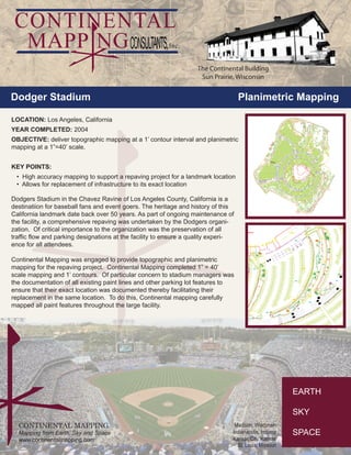
- 1. CONTINENTAL MAPPING Mapping from Earth, Sky and Space www.continentalmapping.com Madison, Wisconsin Indianapolis, Indiana Kansas City, Kansas St. Louis, Missouri Dodger Stadium Planimetric Mapping The Continental Building Sun Prairie, Wisconsin LOCATION: Los Angeles, California YEAR COMPLETED: 2004 OBJECTIVE: deliver topographic mapping at a 1’ contour interval and planimetric mapping at a 1”=40’ scale. KEY POINTS: • High accuracy mapping to support a repaving project for a landmark location • Allows for replacement of infrastructure to its exact location Dodgers Stadium in the Chavez Ravine of Los Angeles County, California is a destinatiion for baseball fans and event goers. The heritage and history of this California landmark date back over 50 years. As part of ongoing maintenance of the facility, a comprehensive repaving was undertaken by the Dodgers organi- zation. Of critical importance to the organization was the preservation of all traffic flow and parking designations at the facility to ensure a quality experi- ence for all attendees. Continental Mapping was engaged to provide topographic and planimetric mapping for the repaving project. Continental Mapping completed 1” = 40’ scale mapping and 1’ contours. Of particular concern to stadium managers was the documentation of all existing paint lines and other parking lot features to ensure that their exact location was documented thereby facilitating their replacement in the same location. To do this, Continental mapping carefully mapped all paint features throughout the large facility.