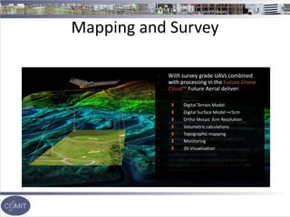
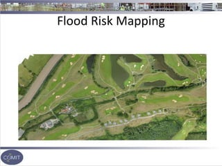
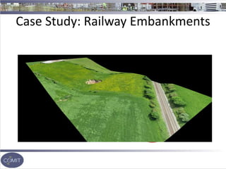
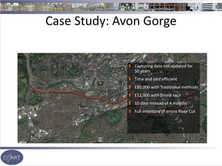
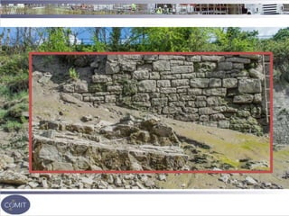
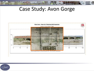
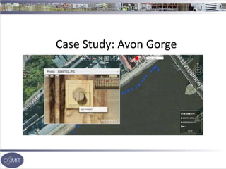
Innovation In….
Mapping
Survey
Inspection
Future Aerial is the UK’s first nationwide drone operations
network (DON™). We allow commercial companies to deploy
multiple fleets of drones at any one time, in any sector.
Andrew Blogg
andrew@futureaerial.com
07919 898259
Dave Bush
Dave.bush@futureaerial.com
07868738159
"It's really hard to digitize the physical world. Satellites are
too high, and two-thirds of the planet's covered by clouds
at any given point in time. Street View is limited to the
street. The way we're going to digitize the planet is by
putting sensors out there on drones, with
anywhere/anytime access to the sky. Once we do that, we'll
create the biggest big data opportunity we've ever seen.”
Chris Anderson - CEO of 3D Robotics
Mapping and Survey
World leaders in UAV aerial mapping and survey
Worked across the global on large scale projects
India
Congo
Ghana
Sierra Leone
Brazil
Jamaica
Europe
US
Pioneered the use of UAVs in African mines
Delivered the first electricity network feasibility
survey in North Africa
Supplying data for the world’s largest Golf
Simulator company
UAVs dramatically reduces the time taken for
traditional survey methods
Our data collation and delivery streamlined
through the Drone Operations Network™ and
Future Drone Cloud™
With survey grade UAVs combined
with processing in the Future Drone
Cloud™ Future Aerial deliver:
Digital Terrain Model
Digital Surface Model =<5cm
Ortho Mosaic 3cm Resolution
Volumetric calculations
Topographic mapping
Monitoring
3D Visualisation
Flood Risk Mapping
Case Study: Railway Embankments
Industrial Inspections
Aerial inspections using UAVs
allow an unparalleled new level
of understanding in
engineering and industrial
asset management
Close-quarter structural civil
engineering inspections that
save time and money
Increasing safety and
enhancing knowledge of
difficult or dangerous access
areas of structures
Case Study: Avon Gorge
Capturing data not updated for
50 years
Time and cost efficient
£80,000 with Traditional methods
£12,000 with Drone tech
10 days instead of 4 months
Full inventory of entire River Cut
Case Study: Avon Gorge
Case Study: QE2 Bridge, Dartford

COMIT Dec 2016 - Innovation in Mapping Survey Inspection

  • 1.
    Innovation In…. Mapping Survey Inspection Future Aerialis the UK’s first nationwide drone operations network (DON™). We allow commercial companies to deploy multiple fleets of drones at any one time, in any sector. Andrew Blogg andrew@futureaerial.com 07919 898259 Dave Bush Dave.bush@futureaerial.com 07868738159
  • 2.
    "It's really hardto digitize the physical world. Satellites are too high, and two-thirds of the planet's covered by clouds at any given point in time. Street View is limited to the street. The way we're going to digitize the planet is by putting sensors out there on drones, with anywhere/anytime access to the sky. Once we do that, we'll create the biggest big data opportunity we've ever seen.” Chris Anderson - CEO of 3D Robotics
  • 3.
    Mapping and Survey Worldleaders in UAV aerial mapping and survey Worked across the global on large scale projects India Congo Ghana Sierra Leone Brazil Jamaica Europe US Pioneered the use of UAVs in African mines Delivered the first electricity network feasibility survey in North Africa Supplying data for the world’s largest Golf Simulator company UAVs dramatically reduces the time taken for traditional survey methods Our data collation and delivery streamlined through the Drone Operations Network™ and Future Drone Cloud™ With survey grade UAVs combined with processing in the Future Drone Cloud™ Future Aerial deliver: Digital Terrain Model Digital Surface Model =<5cm Ortho Mosaic 3cm Resolution Volumetric calculations Topographic mapping Monitoring 3D Visualisation
  • 4.
  • 5.
  • 6.
    Industrial Inspections Aerial inspectionsusing UAVs allow an unparalleled new level of understanding in engineering and industrial asset management Close-quarter structural civil engineering inspections that save time and money Increasing safety and enhancing knowledge of difficult or dangerous access areas of structures
  • 7.
    Case Study: AvonGorge Capturing data not updated for 50 years Time and cost efficient £80,000 with Traditional methods £12,000 with Drone tech 10 days instead of 4 months Full inventory of entire River Cut
  • 9.
  • 10.
  • 11.
    Case Study: QE2Bridge, Dartford