This document provides revision materials and guidance for a GCSE Geography exam covering four key themes: Rivers and Coasts, Natural Hazards, Economic Development, and case studies. It includes checklists of content knowledge for each theme, exam command word definitions, question structure explanations, and case study summaries to focus revision. Study advice emphasizes using evidence and examples to fully explain answers, and connecting specific places and details to case study questions. Resources like websites and contact information are also provided for additional exam preparation support.
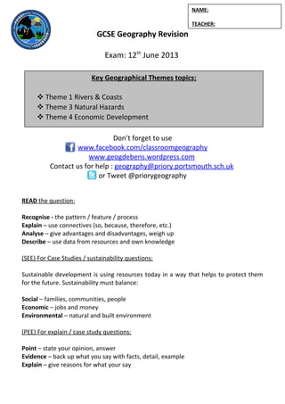
This document provides revision materials and guidance for GCSE Geography exams covering four key themes: Rivers and Coasts, Population and Settlement, Natural Hazards, and Economic Development. It includes checklists of learning objectives for each theme, exam command word definitions, exam question structures, and case studies to review. Revision resources like websites and contact information are also provided to aid students in their preparation.
The document outlines the key concepts and skills a student has learned in a Coasts unit, including being able to explain coastal landforms and processes like erosion, deposition, and longshore drift. It also lists that the student can describe different coastal management strategies and their impacts through case studies. The student indicates they may need to revisit certain topics like specific coastal landforms or management terms.
Case study questions 2014 for OCR B Geography GCSEMrs Coles
This document provides sample case study questions for different topics in geography including rivers, coasts, climatic hazards, tectonic hazards, economic development, and population and settlement. For each topic, it lists key places or examples to use and the main ideas or content to cover in the case study questions. The questions generally involve naming a location, describing key features or changes related to that place, and explaining causes and impacts - requiring at least three developed ideas in the response.
This document provides sample case study questions for different topics in geography. The questions are worth 8 marks each and require students to:
1) Name a specific river, coastal area, example of a climatic or tectonic hazard, aid project, economic activity, or multi-national company.
2) Describe key features of the named location or event, including landforms, impacts, management methods, economic influences, or environmental effects.
3) Explain concepts in detail using multiple examples and diagrams. Sustainability, success of methods, and future influences must be considered for some questions.
This document summarizes a student's knowledge after completing a unit on natural hazards. The student can: 1) describe global patterns of volcanoes and earthquakes and explain reasons for their distribution; 2) explain how the Earth's structure relates to where earthquakes and volcanoes occur; and 3) draw and label different plate boundaries and explain what happens at each type. The student can also analyze and give examples of impacts of various natural hazards.
This document provides sample case study questions for population and settlement, economic development, and natural hazards. The questions guide students to name and locate relevant examples, describe key features and changes with specific details, and explain reasons for trends or impacts of development, considering sustainability and human-environment interactions. Students are prompted to consider a variety of places and contexts globally.
Here are the key terms related to plate tectonics:
- Plate: A massive, rigid slab that comprises the Earth's lithosphere.
- Plate boundary: The line between two tectonic plates.
- Convergent boundary: Where two plates collide, with one sliding under the other.
- Divergent boundary: Where two plates are moving away from each other.
- Transform boundary: Where two plates slide past each other horizontally.
- Subduction zone: Where one plate sinks beneath another into the mantle at a convergent plate boundary.
- Continental crust: The rocky crust under the continents.
- Oceanic crust: The denser crust under the oceans.
I hope this
The document provides information about preparing for the GCSE Geography final exam, including:
- It lists key skills needed for the exam such as annotating, comparing, explaining, and referring to evidence.
- It describes a "command word bingo" mock exam activity involving different exam commands over 25 marks to practice these skills.
- It outlines a mock test case study on consequences, prompting students to think about implications and relationships between concepts.
This document discusses land use in urban areas. It begins by asking questions about how land is used and what land uses can be identified from different data sources. It then presents several models of urban land use, including the Burgess, Hoyt, and MEDC models. It discusses characteristics of different urban land use zones, such as the CBD, industrial zone, inner city, inner suburbs, and outer suburbs. It also provides examples of land use classification into five zones. In conclusion, the document examines questions about sustainable urban redevelopment and how retail provision has changed over time with the rise of out-of-town shopping centers, e-tailing, and clone towns.
The document summarizes information about rivers, coasts, and natural hazards in three locations:
1) The River Derwent in Cumbria, England floods frequently due to heavy rainfall. Flooding is now managed through dredging, flood levees, monitoring, and preparing residents. These strategies help protect homes and businesses in a sustainable way.
2) The coastlines of Highcliffe and Barton-on-Sea in England face erosion. Highcliffe uses hard and soft engineering to protect valuable land, while Barton allows managed retreat since the land has little value.
3) The 2010 eruption of the Eyjafjallajokull volcano in Iceland spread ash across Europe, closing flights. Iceland is well
Portsmouth has experienced land use change. The inner city was redeveloped at Gunwharf Quays into a retail and entertainment area. This has brought economic benefits but also increased traffic and changed the character of the area. Greenwich Millennium Village shows how urban regeneration can create a more sustainable community through green space, affordable housing, and renewable energy. The redevelopment of Stratford for the 2012 Olympics transformed an industrial site into a major transport hub, bringing employment but also higher housing costs.
This document summarizes the key concepts and topics that a student has learned in their Settlement unit. It includes explanations of settlement location advantages, spheres of influence, land use models, patterns of land use in cities, settlement hierarchies, housing redevelopment impacts, sustainable settlements, changing land use, urbanization push and pull factors and impacts, shanty towns, transport issues, counter-urbanization, goods and services in urban and rural areas, town centre decline, and definitions of related terms. The student indicates they may need to revisit some parts of the topic.
This document discusses key concepts related to urban and economic geography. It includes definitions of terms like push and pull factors, urban and rural areas, infrastructure, and zones within cities. It also includes models of urban land use patterns and discusses differences between urban structures in more and less economically developed countries. Case studies are provided on the cities of Portsmouth, UK and Mumbai, India to illustrate characteristics of urban areas.
The document provides information about GCSE Geography revision for key themes and exams. It outlines three levels of understanding - foundational (F), accomplished (A), and competent (C). For each level it describes the scope of geographical knowledge, skills, and abilities students would demonstrate. The document also contains sample exam content on rivers, coasts, flooding case studies and river/coastal landforms.
This document lists case study locations for different topics in geography including rivers and coasts, population and settlement, natural hazards, and economic development. The locations range from cities like Brisbane, Australia and Rio de Janeiro, Brazil to regions like the Zambezi River in Zambia and the Sahel region of Ethiopia. Each case study location is categorized as LEDC, NIC, or MEDC and includes a brief description of the topic being examined such as rivers and flooding, urban change, volcanic eruptions, or the environmental impacts of mining.
- The document provides case studies on rivers, coasts, flooding, economic development aid, and multinational companies for GCSE Geography exams. It includes summaries of the River Derwent in England, coastal landforms at Hengistbury Head, and flood management in Cockermouth. It also summarizes economic development projects by WaterAid in Mali and goat aid in Tanzania, as well as the impacts of Coca-Cola and BP oil spills.
This document provides case studies on various topics in GCSE Geography including coastal landforms in Dorset, coastline management techniques in Hampshire, urban change examples in Portsmouth and London, retail changes over time in Portsmouth, and natural hazards including volcanic eruptions and earthquakes in locations around the world. Specific landforms, management strategies, urban development projects, and hazard events are described along with their impacts and management approaches.
The River Zambezi floods of 2009 in Namibia displaced over 50,000 people from their homes and caused over $136 million in economic losses. Heavy rainfall led to river levels rising by 8 meters, inundating villages and agricultural land. Over 700,000 people, a third of Namibia's population, were affected. The floods demonstrated the local authorities' inability to respond adequately, with relief efforts hampered by poor coordination. International aid of $7 million was provided to help establish relief camps and address health and sanitation issues.
This document provides sample case study questions for different topics in geography. For each topic (rivers, coasts, climatic hazards, tectonic hazards, economic development, population and settlement), it lists key ideas/content and prompts the student to name a place/example and then answer 3 questions about it, providing at least 3 developed ideas for each response. The questions require students to describe locations, landforms, hazards, economic activities, migration patterns, and changes over time, and explain causes and impacts as well as responses and management strategies.
Checklist 2016 - OCR B GCSE specificationMrs Coles
Afforestation can affect river flow in 3 ways:
(1) Trees intercept rainfall which reduces surface runoff entering rivers.
(2) Vegetation increases lag time as seen on hydrographs, slowing river volume.
(3) Less water enters rivers and reaches them more slowly due to interception and reduced surface runoff from vegetation.
This document provides revision materials for a GCSE Geography exam, including key themes, contact information, and resources. It covers topics like rivers, coasts, and landforms. For rivers, it outlines landforms like V-shaped valleys, waterfalls, meanders, and floodplains. For coasts, it discusses landforms including headlands, bays, wave-cut platforms, and beaches. It also provides case studies, definitions of geographic terms, and exam practice questions.
The document provides information about rivers and coasts for a GCSE Geography revision pack. It includes key terms, landforms, and processes related to rivers and coasts, as well as case studies on river and coastal management. Resources for further study are also listed.
This document provides revision materials for a GCSE Geography exam on key themes. It includes information on the exam structure, resources for revision, and details on the three exam sections: natural hazards, population and settlement, and economic development. For the economic development section, it outlines different industry types and changes over time, as well as case studies on topics like goat aid and Coca-Cola. Various practice exam questions are provided at the end related to development indicators, the Brandt line, and Rostow's model of development stages.
This summarizes a document describing the 2010 eruption of the Eyjafjallajokull volcano in Iceland. It began by locating Iceland on the Mid-Atlantic Ridge where the Eurasian and North American tectonic plates are diverging. The causes of the eruption were explained as magma rising to the surface due to plate movement. The effects in Iceland were minor, but the ash cloud spread over Europe, grounding flights and costing airlines billions. Measures to manage volcanic hazards in Iceland focus on evacuations and monitoring, which helped minimize loss of life during this eruption.
Controlled assessment - How distinctive is the coast?Mrs Coles
This document provides guidance for students on conducting a geographical inquiry into how distinctive Hengistbury Head is. It includes instructions on developing key questions, understanding what makes a good C+ grade fieldwork focus, planning data collection methods to answer questions, and logistics for a field trip to Hengistbury Head. Students are asked to individually mind map how they could answer proposed key questions and think about collecting data like maps, surveys, and photographs. The goal is to analyze whether features of Hengistbury Head's coastline make it distinctive.
This document provides guidance for students on conducting a geographical inquiry into the distinctive features of Reculver, a location in England. It outlines the key parts of the inquiry:
1) Setting the scene by making detailed predictions about distinctive features based on evidence from maps, satellite images, and geographical knowledge. This includes describing the location.
2) Using a variety of appropriate techniques and technologies during fieldwork to collect evidence, such as photographs, surveys, and measurements.
3) Presenting data in complex diagrams and maps, and analyzing the evidence in detail to draw a substantiated conclusion regarding what makes Reculver distinctive. Evaluating the success of the inquiry and considering limitations.
The document provides assessment criteria
Portsmouth CBD has experienced land use change over time. Retail and commercial uses have moved to the inner suburbs and outer edge of the city, leaving behind underused land and empty buildings in the city center. The city has redeveloped Gunwharf Quays to attract shops and services back into the city center. While this has boosted the local economy, some argue it has made the city center less unique.
Year 11 exam info revision guide 2015 (OCR B)cranbrookgeog
This document provides information about upcoming geography exams for a student, including:
- Details of two exams - the SDME exam covering economic development topics on May 19, and the Geographical Themes exam covering rivers/coasts, natural hazards, and population/settlement on June 3.
- Links to revision resources like past papers, syllabus information, and revision guides.
- Case study examples and topics to revise for the exam questions on rivers/coasts, population/settlement, and natural hazards.
The document provides a daily lesson log for an 11th grade class on Disaster Risk Reduction and Resilience (DRRR). The objectives are for students to distinguish hazards from natural phenomena, explain how hazards cause disasters, and identify elements at risk. The lesson involves reviewing concepts like vulnerability, conducting hazard mapping of the school, and discussing short-term meteorological hazards and safety measures. Students present their hazard maps and assessments of vulnerabilities. The teacher reflects on students' understanding and how to improve learning.
Exampler for ssc 6 th by iqbal bhat school based assessmentAfra Khan
This document outlines the curriculum for a 6th grade social science class on the environment. The learning outcomes include identifying layers of the Earth's interior and atmosphere, locating climatic regions on a map, and explaining preventive measures for disasters. Students will describe landform formation, the composition and structure of the atmosphere, environmental components and their interrelationships. They will analyze local pollution factors and prevention measures. The assessment techniques involve classroom discussions, maps, diagrams and videos to engage concepts like ecosystems, climate, and pollution. Students will be assessed orally on pictures depicting the sun, oceans, clouds, atmosphere and global climate zones. The teacher aims to effectively teach environmental science using multi-sensory tools to build understanding of physical and human-
This document provides information about weathering and mass movement. It defines weathering as the breakdown of rocks by mechanical, chemical, or biological processes in place. There are three main types of weathering: chemical, biological, and mechanical. Mass movement is defined as the shifting of rocks or loose material down a slope due to the force of gravity overcoming the forces holding the material in place. This can cause cliff retreat and collapse. Factors like rock type, climate, rock structure, and vegetation affect the degree of weathering and mass movement that occurs.
This document provides guidance for a multi-lesson unit on avalanches. Lesson 1 involves watching videos on avalanches and creating a mind map on the definition, types, causes, effects, and safety measures. Lesson 2 focuses on writing a definition and describing the two types of avalanches. Lesson 3 covers the effects of avalanches and analyzing a case study through maps, images and details. Lesson 4 explains methods to reduce avalanche impact such as snow fences, planting trees, building designs, transmitters, education, and early warning systems. The document provides assessment criteria on communication, analysis, map/diagram use, and geographical understanding.
The document discusses management strategies for coastal environments to ensure conservation and sustainable use. It should describe both "hard" and "soft" engineering techniques used to manage coastal erosion and flooding, as well as non-structural approaches like coastal zoning and education programs. Effective management requires balancing environmental protection with public access and development.
This document contains questions related to population, settlement, plate tectonics, and river processes for a geography exam. The questions cover a range of topics including the effects of migration on cities, reasons for declining birth rates, impacts of an aging population, causes and effects of earthquakes and volcanic eruptions, formation of deltas and meanders, measures to reduce flooding, and advantages and challenges of living on floodplains. The questions are broken into sections based on the topics and range from 4 to 7 marks in level of detail required in the response.
The document discusses sea level rise and its effects on Tuvalu, a Pacific island nation. It provides context on the causes of sea level rise including greenhouse gases and global warming. It outlines the environmental, economic, and social impacts of rising sea levels on Tuvalu. Students are tasked with imagining a speech to the UN explaining the causes and effects of sea level rise on Tuvalu and calling for action to address this issue.
The document provides feedback on exam responses for several geography questions. It criticizes answers for lacking detail, examples, and use of terminology. Students are advised to learn case studies in depth and use evidence to back up arguments in order to score higher marks. They are told to cancel social plans and revise more for not demonstrating sufficient knowledge required for A-Level geography exams.
This document provides a curriculum map for a Grade 5 science class unit on Earth's atmosphere and the solar system. The unit consists of 12 lessons over several days covering topics like the hydrologic cycle, heating of land and water, tropical cyclones, climate, seasons, the solar system, and more. Each lesson has clear learning objectives and incorporates activities, discussions, presentations, worksheets and quizzes to help students understand key concepts and practice critical thinking. The overarching goal is for students to realize the complexity of natural systems and promote initiative in identifying and resolving environmental issues.
The document discusses climate change and its effects. It provides definitions of key terms like climate change and global warming. Climate change refers to long-term shifts in weather patterns globally or regionally, while global warming refers specifically to rising surface temperatures. The text states that scientific experts agree climate change is caused by human activities like burning fossil fuels that increase greenhouse gas levels in the atmosphere. Some potential impacts of climate change discussed include rising sea levels, more extreme weather, droughts, and species endangerment. The document also outlines activities for students to help them better understand climate change and its causes and impacts.
This document contains a curriculum plan for geography topics in Year 7. It outlines 5 topics to be covered in Term 1: Weather and Climate, Extreme Weather, Local Area Studies, The Geography of Wales, and Rivers. For each topic, it lists learning objectives, activities, resources, and assessment. It also includes sections on skills development, homework, and applying different levels of understanding.
The document discusses teaching Earth and space science at the elementary level. It lists the main topics covered in the Texas Essential Knowledge and Skills (TEKS) standards, including ecology, geology, weather, and space. For ecology, it focuses on resources, soil/rock cycles, and water/carbon/nitrogen cycles. It provides examples of TEKS standards and discusses effective strategies for teaching topics like soil formation, rock cycles, and natural resources through experiments, models and videos.
The document outlines key topics in environmental studies including:
1. The history of the environmental movement and the role of environmental disasters, media, international agreements, and technology.
2. Environmental value systems including technocentric, ecocentric, and anthropocentric views and examples of societies with contrasting systems.
3. Concepts in ecology including open/closed/isolated systems, equilibrium, resilience, diversity, and pollution.
4. Specific issues like acid rain, fossil fuel use, water demand, DDT, and approaches to pollution management.
The document provides guidance and homework for students, including checking their work for errors, choosing a target to write about in their workbook, and preparing for an upcoming test on climate factors, graphs, atmospheric systems, and weather impacts. It also includes information on hurricanes, such as the natural formation process and a case study on Hurricane Katrina examining causes, impacts, and response.
The document provides information and revision notes for a Level 3 Geography exam, including:
- The exam will take place on September 15 from 1:30-4:30pm in Option B hall or M14A. Students should bring specific supplies.
- The exam consists of 3 papers analyzing natural processes, cultural processes, and applying geographic skills.
- Suggested revision focuses on coastal processes at South Muriwai Beach and tourism development in Rotorua, NZ and Waikiki, Hawaii.
- Formats, criteria, and content that could be assessed are outlined for each paper.
The document provides information and revision notes for a Level 3 Geography exam, including:
- The exam will take place on September 15 from 1:30-4:30pm in Option B hall or M14A. Students should bring specific supplies.
- The exam consists of 3 papers analyzing natural processes, cultural processes, and applying geographic skills.
- Suggested revision focuses on processes at South Muriwai Beach and tourism development in Rotorua and Waikiki. Formats, criteria, and content are outlined for each paper.
- Quizzes are provided to test knowledge of details about Muriwai Beach and tourism in Rotorua and Waikiki.
This document provides an overview of the GCSE Geography course offered at Matravers School. It outlines the key units that will be studied, including climate and the environment, water and landforms, and people and their interaction with work, development and places. It describes the life skills that will be developed through independent enquiry, teamwork, problem solving and use of data. Assessment includes controlled assessments, cross-unit tasks and exams. Reasons for choosing Geography include an interest in understanding the world, a willingness to work hard, and an interest in related topics like business and ICT.
The document provides instructions for an activity where students create characters representing different air masses and place them on a map of the British Isles. They are told to shade each character according to the air temperature, add appropriate clothing, and symbols showing wind and precipitation. Students are then instructed to glue a map to their page, stick the characters in the correct locations, draw arrows indicating the direction of each air mass, and write descriptions of how each air mass affects the weather and climate.
This document provides information about plate tectonics and associated geological phenomena. It begins by describing the layers of the Earth, including the inner and outer core, mantle, and crust. It notes key differences between oceanic and continental crust, and explains convection currents in the mantle. The document then discusses plate boundaries and associated hazards like earthquakes and volcanoes. Specific topics covered include the 2011 Japan earthquake and tsunami, the Montserrat volcanic eruption, measuring earthquakes, predicting seismic activity, earthquake proofing, and responses to natural disasters. Comparisons are drawn between responses to disasters in rich and poor countries.
This document summarizes key concepts in physical geography related to plate tectonics, earthquakes, volcanoes, and case studies of volcanic eruptions and earthquakes. It describes how convection currents in the mantle cause plate movements at destructive, conservative, and constructive plate boundaries. Case studies on the 1995 Montserrat volcano eruption and the 2011 Japanese earthquake and tsunami detail their impacts and responses. A third case study summarizes the 2008 Sichuan earthquake in China that killed over 70,000 people.
The document discusses climate change and its causes. It provides the following key points:
1) In 2008, 193 countries signed an anti-CO2 emissions treaty, except the USA and China. The USA did not believe in global warming under Bush, and China profits from natural resources.
2) The industrial revolution beginning in the 1800s caused a rise in CO2 levels and global temperatures.
3) Human activities like burning fossil fuels are major contributors to increased greenhouse gas emissions and climate change. This will have severe environmental and economic impacts worldwide if left unaddressed.
The document discusses the biosphere and the threats facing it. It defines the biosphere as the regions of Earth inhabited by living organisms, and notes there are 5 major biomes - aquatic, desert, forest, grassland, and tundra - which are further divided. It explains how the biosphere acts as a life support system and provides goods for humans. The major threats to the biosphere are deforestation, pollution, and climate change. Sustainable management of the biosphere's resources is important but faces economic, social, and environmental tensions.
The document provides an overview of the key topics, subtopics, and learning objectives for a geography revision unit on physical geography. It covers several topics including restless earth, climate, the biosphere, water systems, coastal environments, and extreme environments. For each topic, it lists several subtopics and specifics that students should be able to explain, describe, analyze, or evaluate based on examples. The objectives focus on both conceptual understanding of processes and application of knowledge to case studies.
The document provides information about revising for the GCSE Geography exam on People and the Planet. It outlines the exam structure, with sections on population dynamics, consuming resources, and globalization. For population dynamics, it discusses topics like population trends, theories of population change, and case studies on population policies. It also provides information on defining and classifying different resource types, renewable and non-renewable resources, and ways to reduce resource demand.
This document provides information about GCSE Geography revision on dynamic planet topics. It includes case studies on volcanoes like Mt St Helens and Nyiragongo, as well as earthquakes in Kobe, Japan and Sichuan, China. There are exam focus questions on plate tectonics, hazards and management. Additional sections cover climate change in the past and future, threats to biomes, and conservation efforts. Review materials include theory, graphs to interpret, and guidance on key topics to know for the exam.
Case studies unit 2-people and the planetMrs Coles
This document outlines the structure and content covered in a unit on people and the planet. It is divided into 7 sections that cover topics such as population dynamics, consuming resources, globalization, development dilemmas, changing economies, urban environments, and sustainability strategies. Some key places, theories, and case studies mentioned include the one child policy in China, wind power in the Outer Hebrides, global institutions like the IMF and WTO, Rostow's model of development, contrasting regions in the UK, strategies to reduce London's ecological footprint, and examples of self-help schemes in cities like Rio de Janeiro.
The document outlines different sections that will be covered in a unit on the dynamic planet. Section 1 discusses volcanoes and earthquakes in various countries. Section 2 covers climate change topics like the Little Ice Age and Medieval Warm Period. Section 3 is about threats to tropical rainforests and conservation efforts. Section 4 analyzes water issues like desertification, sustainable practices, and dam management. Section 5 examines coastal changes and conflicts. Section 8 looks at environments in Australia and the Arctic, including human adaptations.
Steve Brace opening #TMRGS presentation on value of geographyMrs Coles
Steve Brace (Head of Education at RGS) sharing the value of Geography, how 10% of all PLC business is down to OS data, that geographers are employable, etc. #tMRGS
Richard Maurice's #TMRGS presentation on developing questioningMrs Coles
Richard Maurice's presentation for Teachmeet RGS about developing questioning, that the 5Ws are not enough, subverting the 5minute lesson plan for use by students
Rupert Littlewood - building favelas presentation for #TMRGSMrs Coles
The lesson involves students building model favelas out of various materials to learn about Brazilian favelas. Students are assigned roles like builder, surveyor, and accountant and given a price list and materials budget to construct a waterproof favela with rooms for washing, cooking, and eating that can withstand wind. Their favelas will be judged based on success criteria and grades assigned. During the plenary, groups will report on their favelas and grades received, and next lesson they will provide feedback on how to improve their designs.
Ewan Laurie #TMRGS presentation Hijack geographyMrs Coles
Ewan Laurie's presentation for RGS Teachmeet about getting other people teaching geography across school, pop-up classrooms, and taking over the school!
Jamie Buchanan-Dunlop Digital Explorer #TMRGS presentationMrs Coles
This document discusses the author's experiences learning and teaching geography through personal travels, technology, and pushing the boundaries of what's possible in education. It mentions trips to Morocco in 2006 using a satellite phone, the Middle East in 2007 using data satellites, and creating a "teleport device" and website to share geographic experiences.
Anna Forshaw's #TMRGS presentation on decision makingMrs Coles
This document describes strategies for using layered decision making activities at Key Stage 4 to ensure student progression. It discusses increasing demands like interpreting a wide range of resources and skills. Layered decision making involves students being drip-fed information and having to assess and demonstrate progression through failure. It involves individual, paired, and group work in mixed ability settings using scaffolds to encourage evidence in responses. Roles are designated to encourage considering different stakeholders' perspectives. Questions are used to find out information and make inferences while linking concepts and using peer and self-assessment.
Deb Gostling's presentation for #TMRGS on making real world links between geography and architecture or urban design, redesigning cities and using google earth
1) The document discusses underachieving GCSE geography students and the potential role of executive dysfunction. It notes that executive functions like planning, organization and working memory are necessary skills for problem solving.
2) It provides examples of teacher complaints about students' disorganized work, inability to follow instructions, and lack of focus. These could potentially be signs of executive dysfunction rather than laziness.
3) The document argues that mild or moderate mental disabilities should be recognized and accommodated similarly to physical disabilities. Labeling symptoms rather than students could help target interventions to improve outcomes.
Walmart Business+ and Spark Good for Nonprofits.pdfTechSoup
"Learn about all the ways Walmart supports nonprofit organizations.
You will hear from Liz Willett, the Head of Nonprofits, and hear about what Walmart is doing to help nonprofits, including Walmart Business and Spark Good. Walmart Business+ is a new offer for nonprofits that offers discounts and also streamlines nonprofits order and expense tracking, saving time and money.
The webinar may also give some examples on how nonprofits can best leverage Walmart Business+.
The event will cover the following::
Walmart Business + (https://business.walmart.com/plus) is a new shopping experience for nonprofits, schools, and local business customers that connects an exclusive online shopping experience to stores. Benefits include free delivery and shipping, a 'Spend Analytics” feature, special discounts, deals and tax-exempt shopping.
Special TechSoup offer for a free 180 days membership, and up to $150 in discounts on eligible orders.
Spark Good (walmart.com/sparkgood) is a charitable platform that enables nonprofits to receive donations directly from customers and associates.
Answers about how you can do more with Walmart!"
How to Manage Your Lost Opportunities in Odoo 17 CRMCeline George
Odoo 17 CRM allows us to track why we lose sales opportunities with "Lost Reasons." This helps analyze our sales process and identify areas for improvement. Here's how to configure lost reasons in Odoo 17 CRM
Reimagining Your Library Space: How to Increase the Vibes in Your Library No ...Diana Rendina
Librarians are leading the way in creating future-ready citizens – now we need to update our spaces to match. In this session, attendees will get inspiration for transforming their library spaces. You’ll learn how to survey students and patrons, create a focus group, and use design thinking to brainstorm ideas for your space. We’ll discuss budget friendly ways to change your space as well as how to find funding. No matter where you’re at, you’ll find ideas for reimagining your space in this session.
বাংলাদেশের অর্থনৈতিক সমীক্ষা ২০২৪ [Bangladesh Economic Review 2024 Bangla.pdf] কম্পিউটার , ট্যাব ও স্মার্ট ফোন ভার্সন সহ সম্পূর্ণ বাংলা ই-বুক বা pdf বই " সুচিপত্র ...বুকমার্ক মেনু 🔖 ও হাইপার লিংক মেনু 📝👆 যুক্ত ..
আমাদের সবার জন্য খুব খুব গুরুত্বপূর্ণ একটি বই ..বিসিএস, ব্যাংক, ইউনিভার্সিটি ভর্তি ও যে কোন প্রতিযোগিতা মূলক পরীক্ষার জন্য এর খুব ইম্পরট্যান্ট একটি বিষয় ...তাছাড়া বাংলাদেশের সাম্প্রতিক যে কোন ডাটা বা তথ্য এই বইতে পাবেন ...
তাই একজন নাগরিক হিসাবে এই তথ্য গুলো আপনার জানা প্রয়োজন ...।
বিসিএস ও ব্যাংক এর লিখিত পরীক্ষা ...+এছাড়া মাধ্যমিক ও উচ্চমাধ্যমিকের স্টুডেন্টদের জন্য অনেক কাজে আসবে ...
This presentation includes basic of PCOS their pathology and treatment and also Ayurveda correlation of PCOS and Ayurvedic line of treatment mentioned in classics.
LAND USE LAND COVER AND NDVI OF MIRZAPUR DISTRICT, UPRAHUL
This Dissertation explores the particular circumstances of Mirzapur, a region located in the
core of India. Mirzapur, with its varied terrains and abundant biodiversity, offers an optimal
environment for investigating the changes in vegetation cover dynamics. Our study utilizes
advanced technologies such as GIS (Geographic Information Systems) and Remote sensing to
analyze the transformations that have taken place over the course of a decade.
The complex relationship between human activities and the environment has been the focus
of extensive research and worry. As the global community grapples with swift urbanization,
population expansion, and economic progress, the effects on natural ecosystems are becoming
more evident. A crucial element of this impact is the alteration of vegetation cover, which plays a
significant role in maintaining the ecological equilibrium of our planet.Land serves as the foundation for all human activities and provides the necessary materials for
these activities. As the most crucial natural resource, its utilization by humans results in different
'Land uses,' which are determined by both human activities and the physical characteristics of the
land.
The utilization of land is impacted by human needs and environmental factors. In countries
like India, rapid population growth and the emphasis on extensive resource exploitation can lead
to significant land degradation, adversely affecting the region's land cover.
Therefore, human intervention has significantly influenced land use patterns over many
centuries, evolving its structure over time and space. In the present era, these changes have
accelerated due to factors such as agriculture and urbanization. Information regarding land use and
cover is essential for various planning and management tasks related to the Earth's surface,
providing crucial environmental data for scientific, resource management, policy purposes, and
diverse human activities.
Accurate understanding of land use and cover is imperative for the development planning
of any area. Consequently, a wide range of professionals, including earth system scientists, land
and water managers, and urban planners, are interested in obtaining data on land use and cover
changes, conversion trends, and other related patterns. The spatial dimensions of land use and
cover support policymakers and scientists in making well-informed decisions, as alterations in
these patterns indicate shifts in economic and social conditions. Monitoring such changes with the
help of Advanced technologies like Remote Sensing and Geographic Information Systems is
crucial for coordinated efforts across different administrative levels. Advanced technologies like
Remote Sensing and Geographic Information Systems
9
Changes in vegetation cover refer to variations in the distribution, composition, and overall
structure of plant communities across different temporal and spatial scales. These changes can
occur natural.
How to Fix the Import Error in the Odoo 17Celine George
An import error occurs when a program fails to import a module or library, disrupting its execution. In languages like Python, this issue arises when the specified module cannot be found or accessed, hindering the program's functionality. Resolving import errors is crucial for maintaining smooth software operation and uninterrupted development processes.
How to Setup Warehouse & Location in Odoo 17 InventoryCeline George
In this slide, we'll explore how to set up warehouses and locations in Odoo 17 Inventory. This will help us manage our stock effectively, track inventory levels, and streamline warehouse operations.
This presentation was provided by Steph Pollock of The American Psychological Association’s Journals Program, and Damita Snow, of The American Society of Civil Engineers (ASCE), for the initial session of NISO's 2024 Training Series "DEIA in the Scholarly Landscape." Session One: 'Setting Expectations: a DEIA Primer,' was held June 6, 2024.
Film vocab for eal 3 students: Australia the movie
GCSE Checklist 2013
1. GCSE Geography Revision
Exam: 12th
June 2013
Don’t forget to use
www.facebook.com/classroomgeography
www.geogdebens.wordpress.com
Contact us for help : geography@priory.portsmouth.sch.uk
or Tweet @priorygeography
READ the question:
Recognise - the pattern / feature / process
Explain – use connectives (so, because, therefore, etc.)
Analyse – give advantages and disadvantages, weigh up
Describe – use data from resources and own knowledge
(SEE) For Case Studies / sustainability questions:
Sustainable development is using resources today in a way that helps to protect them
for the future. Sustainability must balance:
Social – families, communities, people
Economic – jobs and money
Environmental – natural and built environment
(PEE) For explain / case study questions:
Point – state your opinion, answer
Evidence – back up what you say with facts, detail, example
Explain – give reasons for what your say
Key Geographical Themes topics:
Theme 1 Rivers & Coasts
Theme 3 Natural Hazards
Theme 4 Economic Development
NAME:
TEACHER:
2. Exam command words
Command word: What it means
Compare Show similarities and differences. A balanced answer is
required.
Consider Describe and give your thoughts on the subject.
Contrast Point out only the differences between two items.
Define Explain the precise meaning of a concept / word.
Describe Say what something is like, how it works, use adjectives.
Discuss Explain an item or concept, give details about it using info /
examples / facts. Give both points of view & come to a
conclusion.
Examine Investigate in detail, offer evidence for and against.
Explain Offer a detailed and exact explanation of an idea or principle.
Identify / State Express the relevant points briefly and clearly.
Illustrate Provide examples to demonstrate or prove a subject.
Justify Give reasons to support your answer / argument, and the main
objections
Summarise / Outline Provide a short summary of all the info on a subject
It might be useful to underline command words in an exam question.
Answering the questions…..
[1mark] questions = can be answered with a single word or simple sentence, often using
data or fact. E.g. Name a climatic hazard = drought [1]
[2mark] questions = either needs two simple sentences, often using data OR needs one
point then explained. E.g. Explain why LEDCs have a higher death rate = poor healthcare
leading to diseases and a lack of food [2] OR LEDCs have a higher death rate due to a
lack of medicine (point) and healthcare which means they cannot treat illnesses and
disease so die more easily (explain) [2]
[4mark] questions = requires you to compare, consider evidence, use facts, refer to
examples. The answer should be detailed. You should probably describe and explain.
P.E.E.
3. Theme 1 Rivers & Coasts checklist
Now I’ve reached the end of the Rivers & Coasts unit:
Yes Think so No
I can understand and define the 4 types of erosion
I can explain how the geology of an area influences how
rapidly it is eroded
I can describe and explain longshore drift & its effects
I can name types of hard & soft coastal management
I can name types of hard & soft river management
I can evaluate how sustainable landform management is
I can name and describe a case study of coastal erosion
and the management used to protect it
I can name and describe a case study of river flooding
and the responses to flooding in an MEDC
I can give examples of primary & secondary impacts of
floods
I can explain why river flooding occurs
I can describe, analyse and explain the river hydrograph
I can describe and explain how a river changes from the
upper to middle to lower course
I can describe and explain river landforms such as
waterfalls, v-shape valleys, gorges, meanders, estuaries,
floodplains…
I can describe and explain the causes of rotational cliff
slumping and formation of headlands, bays, caves,
arches, stacks and stumps
I can describe and explain the formation of beaches,
bars, spits and tombolos
I can describe how the coast is used & how this
influences coastal management policy
I can describe how a river transports its load and causes
erosion and deposition in different areas
I can explain what these terms mean:
Attrition Abrasion Hydraulic action Corrosion cliff rotational slumping cliff drainage
Groynes Longshore drift Beach replenishment Gabionsrock armour bays
spits caves, arches, stacks & stumps resistant rock less resistant rock headlands
Theme 3 Natural Hazards checklist
4. Now I’ve reached the end of the natural hazard unit:
Yes Think so No
I can describe the global distribution of volcanoes and earthquakes and give
reasons for this pattern of distribution.
I can draw and label the structure of the earth. I can explain how this is
important in explaining why earthquakes and volcanoes occur.
I can draw the different plate boundaries and label the features of them.
Constructive (divergent), destructive (convergent) and conservative (transform).
I can explain what happens at each type of boundary: divergent, convergent
and conservative/transform
I can give examples of economic, environmental and social impacts of
earthquakes and volcanoes.
I can give examples of primary and secondary impacts of earthquakes
I can name an earthquake in an LEDC and MEDC and describe the impacts
and the responses. E.g. Haiti 2011, Japan 2011
I can name a volcano in a MEDC and LEDC and describe the impacts and
responses. E.g. Iceland 2011, Montserrat 1997
I can explain how the impact of natural hazards can be reduced e.g.
technology, building techniques, education, prediction, evacuation planning,
aid etc
I can describe and explain the global distribution of tropical cyclones and
droughts.
I can explain why tropical cyclones occur and in those areas
I can give examples of economic, environmental and social impacts of tropical
cyclones
I can name a MEDC & LEDC case study of a tropical storm and its causes,
impacts and responses e.g. Hurricane Katrina, USA 2005 & Cyclone Nargis,
Burma 2008
I can give reasons for the differences in impacts between LEDC and MEDC
I can explain the physical (climatic) and human (overpopulation) causes of
droughts
I can explain the social, economic and environmental impacts of droughts
I can name an MEDC & LEDC drought case study with causes, impacts and
responses e.g. Australia La Nina 2011, the Sahel Ethiopia 1985-onward
I can explain why economic development can influence the severity of the
impact of a hazard
I can explain why people choose to continue to live in hazardous areas
I can explain what these terms mean:
Natural hazard Epicentre Eye Infrastructure Mantle Tectonic plate Magma
Mid Ocean Ridge Tsunami Levees Drought Storm surge Subduction zone
Convergent Divergent Transform Overgrazing Overpopulation Desertification
Theme 4 Economic Development checklist
5. Now I’ve reached the end of the Economic
Development unit:
Yes Think so No
I can explain what is meant by ‘development’ and how
development indicators are used to measure it
I can suggest how development means more than just
wealth and be able to explain quality of life
I can describe and explain types of poverty and attempts
to reduce poverty
I can suggest what the ‘development gap’ / North-South
divide is and why it exists
I can suggest how development can be affected by aid,
name different kinds of aid, and describe how
sustainable they are
I can describe & evaluate an aid project such as Water
Aid, Goat Aid or Computer Aid – including how
sustainable it is
I understand what employment structure means & can
explain primary, secondary, tertiary & quaternary
employment
I can explain how & why employment patterns change
over time – comparing LEDC, NIC and MEDC examples
I understand the social, economic & environmental
factors that influence where an industry locates and how
this changes
I can name, describe & explain the impacts of industries
in LEDCs and MEDCs and NICs
I have knowledge of my case studies (primary – Kaweh
Ijen sulphur mining, secondary – South Korea
manufacturing, tertiary – Portsmouth retail, quaternary –
Cambridge science parks)
I can describe and explain what a MNC is and the
impacts of it (positive and negative) on the host country
(e.g. Coca Cola, India)
I can explain how MNCs and globalisation affect
development
I can describe and explain the effects of industries upon
the environment
I can explain what these terms mean:
Development indicator Quality of life HDI sustainable development NIC
Absolute poverty Relative poverty North-South divide Brandt line Bilateral aid
Primary employment Secondary employment Tertiary employment Quaternary industry
GDP per capita MNC Outsourcing Footloose industry Globalisation
6. GCSE Geography Case Study revision list
Theme 1 Rivers & Coasts
Case Study About Need to know
River Derwent, England A River Valley & its
landforms
AND
River flooding in an MEDC
Location
Landforms (waterfalls, meanders, etc,.)
Changes over river course
Causes, effects of floods and responses
to it
Hengistbury Head
or
Swanage Bay (Old Harry Rocks)
A coastal area and its
landforms
Location
Landforms (spit, headland, bay, beaches,
caves, arches, stacks, stumps)
Causes of and management of landforms
Highcliffe & Barton-on-Sea
OR
Happisburgh
Management of a coastal
area
Location
Landforms and processes
Basic geology
Types of management in place & how
sustainable these are
Theme 3 Natural Hazards
Case Study About Need to know:
Haiti earthquake 2010 One tectonic hazard
event in an LEDC. Causes, effects (primary / secondary) &
response to the hazard.
Be aware that the level of economic
development influences the severity of
the impact of a hazard, i.e. LEDCs more
likely to have greater death toll, MEDCs
likely to have more $ damages
Methods of hazard protection, prediction
& preparation.
Japanese Earthquake 2011
Or
Iceland volcano 2010
One tectonic hazard
event in an MEDC.
Sahel Ethiopia drought
Or
Cyclone Nargis (Burma)
One climatic hazard
event in an LEDC.
Hurricane Katrina
Or
Australia drought (La Nina)
One climatic hazard
event in an MEDC.
Theme 4 Economic Development
Each examination question has a case study at the end worth 8 marks. You will
need to apply relevant knowledge and understanding of real examples.
7. Case Study About Need to know
Water Aid / Computer Aid / Goat Aid Case study of an aid
project in an LEDC
Why aid is needed, types of aid
That some aid is more sustainable than
others & why.
LEDC: sulphur mining (primary)
Indonesia, Kawah Ijen volcano
NIC: manufacturing (secondary) in
South Korea
MEDC: retail / services (tertiary) in
Gunwharf Quays Portsmouth, UK
And research & development
(quaternary) Cambridge Science
Parks
Factors that affect the
location of industry in
LEDCs and MEDCs
There are physical and human factors
that influence the location of different
types of industry.
Industry locations have to change over
time (due to competition, lack of
resources, environmental decline, lack of
workers, etc.)
Coca Cola (secondary
manufacturing), India
A case study of a MNC
investment in a specific
area in an international
context.
The effects MNCs have in the areas they
choose to locate in and in other places.
Positive & negative social, environmental
and economic impacts of MNCs.
Coca Cola, India (secondary)
Or
BP Oil Spill Gulf of Mexico
A case study of
where conflicts exist
between economic
development and
environmental
damage
How industry and economic development
can have an impact on the environment.
The impacts of industry.
How these conflicts are managed
sustainably.
Remember case study questions are Level marked i.e.:
Level 1 (1-3 marks): basic description showing limited knowledge and
understanding. Meaning not communicated very clearly.
Level 2 (4-6 marks): Refers to named case study, some relevant knowledge
demonstrated and some facts/evidence are included to support answer.
Meaning is communicated clearly.
Level 3 (7-8 marks): Valid case study given and a full range of place-specific
detail used to effectively answer the question. Good knowledge and
understanding shown through facts / evidence. Meaning is communicated
very clearly.
You should try to write three well developed ideas in your answer! P.E.E.L.