Richard Maurice's #TMRGS presentation on developing questioning
•Download as PPT, PDF•
0 likes•669 views

Richard Maurice's presentation for Teachmeet RGS about developing questioning, that the 5Ws are not enough, subverting the 5minute lesson plan for use by students
Report
Share
Report
Share

Recommended
The Evolution of Marketing Research
This document contains a series of tweets from the #MRIA2014 conference hosted by @LoveStats. The tweets cover various topics related to medicine, tools, and research throughout history. They also discuss what doctors, engineers, and market researchers do. The document concludes with a song parody written and performed by Annie Pettit about innovating in market research. Contact information is provided for Annie Pettit and Jonathan Cheriff of Peanut Labs.
Intridea ajn-rttos OA NYC Summit
The document discusses Intridea, a company that designs and develops web, mobile, and data applications. It provides information on Intridea's services, founders in Washington DC, over 40 employees including designers, developers and scientists, working with clients, hiring practices, and growing nature. It also introduces Anthony Nyström as a fellow and managing director of engineering at Intridea.
Awright openanalytics-mapmeter
The document discusses a product called MapMeter that provides monitoring and analytics for geospatial services. It allows users to discover how their geospatial services are being used, analyze performance and usage trends, and monitor servers to manage services proactively. The presentation goes through MapMeter's key capabilities like real-time and historical performance views, layered usage analytics, user activity insights, and tools for discovering bottlenecks and optimizing services.
Let's talk about...
The document draws analogies between file formats and animals. It discusses how files can be identified by metadata or branding like cattle, but these can be faked. It also discusses how the same data can be parsed differently by experts in different fields. Files can contain extra or foreign data and still be valid, like if a cow swallowed a microSD card. The document also mentions polyglot files that contain multiple file types and chimera files with multiple bodies or heads.
Human geography population policies
Stage 4 of the demographic transition model is the most sustainable population stage because birth rates are low and death rates are low, leading to a stable population size. Stage 5 is less sustainable as low birth rates coupled with slightly higher death rates could cause the population to decline over time. The document discusses using case studies of China and Kerala, India to analyze population policies and their consequences through adding details to spider diagrams and classroom discussion before practicing exam questions.
Summer Competition
The Geography Department at the Appleton School is holding a Geosquishing competition over the summer of 2010. Students are asked to take photographs of famous or infamous locations that they visit on their travels and "GeoSquish" or squeeze the location between their hands. Photographs should be submitted to a geography teacher or emailed to phunt@theappletonschool.org by September 18, 2010. The winner will have their geosquished image printed on a mug.
Edgar Frost
Eddie Frost was born in 1920 in London and enlisted in the British army in 1940 at age 20. He trained as a glider pilot and took part in Operation Varsity, the largest airborne operation of World War 2 over the Rhine River in Germany in March 1945. During the dangerous landing, Eddie's glider encountered heavy fire and he was killed at just 25 years old. He was buried in the Reichswald Forest War Cemetery in Germany.
Method Table
This document discusses methods for data collection but provides no details about any specific methods, concepts, descriptions, importance, problems, limitations, or potential developments. It only includes a header for a "Method Linked concept Description" but no corresponding information.
George and alfie
We learned about coastal landforms like coastlines and tidal patterns. The course taught us the different types of sea defenses such as groynes, sea walls, and beach reconstruction. For our final project, we had fun making a model showing these various defenses using materials like cardboard and popsicle sticks. The most enjoyable parts of the course were creating the model and meeting new friends.
Alice
The document summarizes a student's geography course on coastal protection. It details that the student learned how tides and waves are formed, how coastlines are protected, and construction methods and costs for rip rap and groynes. The student made a model demonstrating these concepts using materials like tissue paper, straws, and lolly sticks, and enjoyed making the model and meeting new people in the course.
Eleanor
This student summarizes what they learned in a geography course for gifted and talented students. They learned about coastal landforms like groynes and rip rap, how waves are formed, and the costs associated with coastal construction projects. To demonstrate their learning, the student created a simple model of a coastal area out of paper, sticks, and straw, showing features like a sea wall, groynes, rip rap, sand, sea, and cliff. They enjoyed making the model and a course video, and conducting outdoor demonstrations of wave formation.
M1 june 2012
This document is an exam paper for Mechanics M1. It contains instructions for candidates on how to fill out their details, information about materials allowed and the structure of the paper. The paper contains 7 questions worth a total of 75 marks. It directs candidates to show working, label answers and provide responses in the spaces provided. Question 1 involves two particles colliding and calculates their speeds before and after, as well as determining the value of m based on impulse.
Human geography revision dtm
The document discusses the demographic transition model (DTM), which describes the stages of change in birth and death rates and population growth of countries. It asks the student to draw and label the DTM, summarize each stage including key features of birth, death, and total population over five minutes. It also provides exam questions asking to describe the use of the DTM and explain what happens at stage 3.
5 ways to differentiate @liz b pattison
Liz Pattison's presentation for #TMRGS looking at differentiation using learning grids, SOLO, lead learners and learning pyramids
Schoenburg- AREA OF STUDY 2
The document provides information about Arnold Schoenberg's piece "Peripetie" including definitions of musical terms used in the piece such as hexachord, diminution, and glissando. It gives one example of Schoenberg's use of canon and explains that atonal music has no set key or tonality. The document also identifies that symbols "H" and "N" represent the most and second most important melodies. It cites five features showing the piece was composed in the 20th century including its atonal angular style, use of extended techniques, focus on timbre, and lack of clear form.
Shakespeare was a Geographer - so was Pythagoras (Jo Debens #TMRGS)
This document discusses whether geography is considered a subject and highlights some of the key concepts and skills involved in geography. It notes that an geographer would deal with places, vocabulary, context, processes, analysis, relationships, interactions, management, problem-solving, conclusions, decision-making, practical skills, GIS, numeracy, literacy, and fieldwork. It also argues that famous historical figures like William Shakespeare and Pythagoras were essentially geographers in their analysis of places, landscapes, climate, and environments in their works. A number of extracts from literature are presented and analyzed from a geographic perspective.
C2 june 2012
This document appears to be an exam paper for a mathematics course. It contains instructions for candidates taking the exam, information about the structure and format of the exam, the exam questions themselves, and spaces for candidates to write their answers. The exam consists of 9 multiple choice and short answer questions testing a range of mathematics concepts and skills, including binomial expansion, solving equations, factorizing polynomials, calculating areas, and using integration rules. Candidates are instructed to show their working, write answers in the spaces provided, and include relevant working and steps to receive full marks. The first 3 questions are presented for summary.
Geography Controlled assessment
The document provides guidance on how to get maximum marks on a geography controlled assessment. It recommends that the introduction should explain the hypothesis being tested, what data will be collected and where, as well as why the theme is important to study. Key terms associated with the theme, such as quarrying and land use, should also be defined. Maps of different scales should be used to locate the study area and show where data will be collected. A method table is then outlined listing the types of data to be collected, such as through questionnaires, surveys, and field sketches, to analyze factors like land use, the environment, and economic benefits.
Geography Revision Pack AQA/Edexcel
The document provides revision strategies and explanations of key terms for GCSE Geography exams on topics related to water, landforms, people, climate, and development. It defines command words that may appear in exam questions and explains the structure of Papers 1-4. Key terms are defined for topics like river processes, landforms, and the water cycle. Revision methods like flashcards, mind maps, and practice questions are suggested.
Changing climate pp
The document discusses climate change and its causes. It provides the following key points:
1) In 2008, 193 countries signed an anti-CO2 emissions treaty, except the USA and China. The USA did not believe in global warming under Bush, and China profits from natural resources.
2) The industrial revolution beginning in the 1800s caused a rise in CO2 levels and global temperatures.
3) Human activities like burning fossil fuels are major contributors to increased greenhouse gas emissions and climate change. This will have severe environmental and economic impacts worldwide if left unaddressed.
Geography gcse year 11 examination preparation booklet
The document provides information for students preparing for their Year 11 Geography GCSE examination. It outlines the two sections that will be examined, including topics like population change, migration, urban environments, and tourism. It also includes a glossary defining key terms used in the subject.
Restless earth
This document provides information about plate tectonics and associated geological phenomena. It begins by describing the layers of the Earth, including the inner and outer core, mantle, and crust. It notes key differences between oceanic and continental crust, and explains convection currents in the mantle. The document then discusses plate boundaries and associated hazards like earthquakes and volcanoes. Specific topics covered include the 2011 Japan earthquake and tsunami, the Montserrat volcanic eruption, measuring earthquakes, predicting seismic activity, earthquake proofing, and responses to natural disasters. Comparisons are drawn between responses to disasters in rich and poor countries.
SDME revision pack 2016
The document provides information about rivers and coasts for a GCSE Geography revision pack. It includes key terms, landforms, and processes related to rivers and coasts, as well as case studies on river and coastal management. Resources for further study are also listed.
Mr happy air masses (Tony Cassidy)
The document provides instructions for an activity where students create characters representing different air masses and place them on a map of the British Isles. They are told to shade each character according to the air temperature, add appropriate clothing, and symbols showing wind and precipitation. Students are then instructed to glue a map to their page, stick the characters in the correct locations, draw arrows indicating the direction of each air mass, and write descriptions of how each air mass affects the weather and climate.
Restless earth
This document summarizes key concepts in physical geography related to plate tectonics, earthquakes, volcanoes, and case studies of volcanic eruptions and earthquakes. It describes how convection currents in the mantle cause plate movements at destructive, conservative, and constructive plate boundaries. Case studies on the 1995 Montserrat volcano eruption and the 2011 Japanese earthquake and tsunami detail their impacts and responses. A third case study summarizes the 2008 Sichuan earthquake in China that killed over 70,000 people.
Battle for the biosphere pp
The document discusses the biosphere and the threats facing it. It defines the biosphere as the regions of Earth inhabited by living organisms, and notes there are 5 major biomes - aquatic, desert, forest, grassland, and tundra - which are further divided. It explains how the biosphere acts as a life support system and provides goods for humans. The major threats to the biosphere are deforestation, pollution, and climate change. Sustainable management of the biosphere's resources is important but faces economic, social, and environmental tensions.
Plc edexcel unit 1
The document provides an overview of the key topics, subtopics, and learning objectives for a geography revision unit on physical geography. It covers several topics including restless earth, climate, the biosphere, water systems, coastal environments, and extreme environments. For each topic, it lists several subtopics and specifics that students should be able to explain, describe, analyze, or evaluate based on examples. The objectives focus on both conceptual understanding of processes and application of knowledge to case studies.
Gcse unit 2 revision-edited for 2014
The document provides information about revising for the GCSE Geography exam on People and the Planet. It outlines the exam structure, with sections on population dynamics, consuming resources, and globalization. For population dynamics, it discusses topics like population trends, theories of population change, and case studies on population policies. It also provides information on defining and classifying different resource types, renewable and non-renewable resources, and ways to reduce resource demand.
Gcse unit 1 revision-edited for 2014
This document provides information about GCSE Geography revision on dynamic planet topics. It includes case studies on volcanoes like Mt St Helens and Nyiragongo, as well as earthquakes in Kobe, Japan and Sichuan, China. There are exam focus questions on plate tectonics, hazards and management. Additional sections cover climate change in the past and future, threats to biomes, and conservation efforts. Review materials include theory, graphs to interpret, and guidance on key topics to know for the exam.
Case studies unit 2-people and the planet
This document outlines the structure and content covered in a unit on people and the planet. It is divided into 7 sections that cover topics such as population dynamics, consuming resources, globalization, development dilemmas, changing economies, urban environments, and sustainability strategies. Some key places, theories, and case studies mentioned include the one child policy in China, wind power in the Outer Hebrides, global institutions like the IMF and WTO, Rostow's model of development, contrasting regions in the UK, strategies to reduce London's ecological footprint, and examples of self-help schemes in cities like Rio de Janeiro.
More Related Content
Viewers also liked
George and alfie
We learned about coastal landforms like coastlines and tidal patterns. The course taught us the different types of sea defenses such as groynes, sea walls, and beach reconstruction. For our final project, we had fun making a model showing these various defenses using materials like cardboard and popsicle sticks. The most enjoyable parts of the course were creating the model and meeting new friends.
Alice
The document summarizes a student's geography course on coastal protection. It details that the student learned how tides and waves are formed, how coastlines are protected, and construction methods and costs for rip rap and groynes. The student made a model demonstrating these concepts using materials like tissue paper, straws, and lolly sticks, and enjoyed making the model and meeting new people in the course.
Eleanor
This student summarizes what they learned in a geography course for gifted and talented students. They learned about coastal landforms like groynes and rip rap, how waves are formed, and the costs associated with coastal construction projects. To demonstrate their learning, the student created a simple model of a coastal area out of paper, sticks, and straw, showing features like a sea wall, groynes, rip rap, sand, sea, and cliff. They enjoyed making the model and a course video, and conducting outdoor demonstrations of wave formation.
M1 june 2012
This document is an exam paper for Mechanics M1. It contains instructions for candidates on how to fill out their details, information about materials allowed and the structure of the paper. The paper contains 7 questions worth a total of 75 marks. It directs candidates to show working, label answers and provide responses in the spaces provided. Question 1 involves two particles colliding and calculates their speeds before and after, as well as determining the value of m based on impulse.
Human geography revision dtm
The document discusses the demographic transition model (DTM), which describes the stages of change in birth and death rates and population growth of countries. It asks the student to draw and label the DTM, summarize each stage including key features of birth, death, and total population over five minutes. It also provides exam questions asking to describe the use of the DTM and explain what happens at stage 3.
5 ways to differentiate @liz b pattison
Liz Pattison's presentation for #TMRGS looking at differentiation using learning grids, SOLO, lead learners and learning pyramids
Schoenburg- AREA OF STUDY 2
The document provides information about Arnold Schoenberg's piece "Peripetie" including definitions of musical terms used in the piece such as hexachord, diminution, and glissando. It gives one example of Schoenberg's use of canon and explains that atonal music has no set key or tonality. The document also identifies that symbols "H" and "N" represent the most and second most important melodies. It cites five features showing the piece was composed in the 20th century including its atonal angular style, use of extended techniques, focus on timbre, and lack of clear form.
Shakespeare was a Geographer - so was Pythagoras (Jo Debens #TMRGS)
This document discusses whether geography is considered a subject and highlights some of the key concepts and skills involved in geography. It notes that an geographer would deal with places, vocabulary, context, processes, analysis, relationships, interactions, management, problem-solving, conclusions, decision-making, practical skills, GIS, numeracy, literacy, and fieldwork. It also argues that famous historical figures like William Shakespeare and Pythagoras were essentially geographers in their analysis of places, landscapes, climate, and environments in their works. A number of extracts from literature are presented and analyzed from a geographic perspective.
C2 june 2012
This document appears to be an exam paper for a mathematics course. It contains instructions for candidates taking the exam, information about the structure and format of the exam, the exam questions themselves, and spaces for candidates to write their answers. The exam consists of 9 multiple choice and short answer questions testing a range of mathematics concepts and skills, including binomial expansion, solving equations, factorizing polynomials, calculating areas, and using integration rules. Candidates are instructed to show their working, write answers in the spaces provided, and include relevant working and steps to receive full marks. The first 3 questions are presented for summary.
Geography Controlled assessment
The document provides guidance on how to get maximum marks on a geography controlled assessment. It recommends that the introduction should explain the hypothesis being tested, what data will be collected and where, as well as why the theme is important to study. Key terms associated with the theme, such as quarrying and land use, should also be defined. Maps of different scales should be used to locate the study area and show where data will be collected. A method table is then outlined listing the types of data to be collected, such as through questionnaires, surveys, and field sketches, to analyze factors like land use, the environment, and economic benefits.
Geography Revision Pack AQA/Edexcel
The document provides revision strategies and explanations of key terms for GCSE Geography exams on topics related to water, landforms, people, climate, and development. It defines command words that may appear in exam questions and explains the structure of Papers 1-4. Key terms are defined for topics like river processes, landforms, and the water cycle. Revision methods like flashcards, mind maps, and practice questions are suggested.
Changing climate pp
The document discusses climate change and its causes. It provides the following key points:
1) In 2008, 193 countries signed an anti-CO2 emissions treaty, except the USA and China. The USA did not believe in global warming under Bush, and China profits from natural resources.
2) The industrial revolution beginning in the 1800s caused a rise in CO2 levels and global temperatures.
3) Human activities like burning fossil fuels are major contributors to increased greenhouse gas emissions and climate change. This will have severe environmental and economic impacts worldwide if left unaddressed.
Geography gcse year 11 examination preparation booklet
The document provides information for students preparing for their Year 11 Geography GCSE examination. It outlines the two sections that will be examined, including topics like population change, migration, urban environments, and tourism. It also includes a glossary defining key terms used in the subject.
Restless earth
This document provides information about plate tectonics and associated geological phenomena. It begins by describing the layers of the Earth, including the inner and outer core, mantle, and crust. It notes key differences between oceanic and continental crust, and explains convection currents in the mantle. The document then discusses plate boundaries and associated hazards like earthquakes and volcanoes. Specific topics covered include the 2011 Japan earthquake and tsunami, the Montserrat volcanic eruption, measuring earthquakes, predicting seismic activity, earthquake proofing, and responses to natural disasters. Comparisons are drawn between responses to disasters in rich and poor countries.
SDME revision pack 2016
The document provides information about rivers and coasts for a GCSE Geography revision pack. It includes key terms, landforms, and processes related to rivers and coasts, as well as case studies on river and coastal management. Resources for further study are also listed.
Viewers also liked (15)
Shakespeare was a Geographer - so was Pythagoras (Jo Debens #TMRGS)
Shakespeare was a Geographer - so was Pythagoras (Jo Debens #TMRGS)
Geography gcse year 11 examination preparation booklet
Geography gcse year 11 examination preparation booklet
More from Mrs Coles
Mr happy air masses (Tony Cassidy)
The document provides instructions for an activity where students create characters representing different air masses and place them on a map of the British Isles. They are told to shade each character according to the air temperature, add appropriate clothing, and symbols showing wind and precipitation. Students are then instructed to glue a map to their page, stick the characters in the correct locations, draw arrows indicating the direction of each air mass, and write descriptions of how each air mass affects the weather and climate.
Restless earth
This document summarizes key concepts in physical geography related to plate tectonics, earthquakes, volcanoes, and case studies of volcanic eruptions and earthquakes. It describes how convection currents in the mantle cause plate movements at destructive, conservative, and constructive plate boundaries. Case studies on the 1995 Montserrat volcano eruption and the 2011 Japanese earthquake and tsunami detail their impacts and responses. A third case study summarizes the 2008 Sichuan earthquake in China that killed over 70,000 people.
Battle for the biosphere pp
The document discusses the biosphere and the threats facing it. It defines the biosphere as the regions of Earth inhabited by living organisms, and notes there are 5 major biomes - aquatic, desert, forest, grassland, and tundra - which are further divided. It explains how the biosphere acts as a life support system and provides goods for humans. The major threats to the biosphere are deforestation, pollution, and climate change. Sustainable management of the biosphere's resources is important but faces economic, social, and environmental tensions.
Plc edexcel unit 1
The document provides an overview of the key topics, subtopics, and learning objectives for a geography revision unit on physical geography. It covers several topics including restless earth, climate, the biosphere, water systems, coastal environments, and extreme environments. For each topic, it lists several subtopics and specifics that students should be able to explain, describe, analyze, or evaluate based on examples. The objectives focus on both conceptual understanding of processes and application of knowledge to case studies.
Gcse unit 2 revision-edited for 2014
The document provides information about revising for the GCSE Geography exam on People and the Planet. It outlines the exam structure, with sections on population dynamics, consuming resources, and globalization. For population dynamics, it discusses topics like population trends, theories of population change, and case studies on population policies. It also provides information on defining and classifying different resource types, renewable and non-renewable resources, and ways to reduce resource demand.
Gcse unit 1 revision-edited for 2014
This document provides information about GCSE Geography revision on dynamic planet topics. It includes case studies on volcanoes like Mt St Helens and Nyiragongo, as well as earthquakes in Kobe, Japan and Sichuan, China. There are exam focus questions on plate tectonics, hazards and management. Additional sections cover climate change in the past and future, threats to biomes, and conservation efforts. Review materials include theory, graphs to interpret, and guidance on key topics to know for the exam.
Case studies unit 2-people and the planet
This document outlines the structure and content covered in a unit on people and the planet. It is divided into 7 sections that cover topics such as population dynamics, consuming resources, globalization, development dilemmas, changing economies, urban environments, and sustainability strategies. Some key places, theories, and case studies mentioned include the one child policy in China, wind power in the Outer Hebrides, global institutions like the IMF and WTO, Rostow's model of development, contrasting regions in the UK, strategies to reduce London's ecological footprint, and examples of self-help schemes in cities like Rio de Janeiro.
Case studies unit 1-dynamic planet
The document outlines different sections that will be covered in a unit on the dynamic planet. Section 1 discusses volcanoes and earthquakes in various countries. Section 2 covers climate change topics like the Little Ice Age and Medieval Warm Period. Section 3 is about threats to tropical rainforests and conservation efforts. Section 4 analyzes water issues like desertification, sustainable practices, and dam management. Section 5 examines coastal changes and conflicts. Section 8 looks at environments in Australia and the Arctic, including human adaptations.
Key themes revision pack 2016
This document provides revision materials for a GCSE Geography exam on key themes. It includes information on the exam structure, resources for revision, and details on the three exam sections: natural hazards, population and settlement, and economic development. For the economic development section, it outlines different industry types and changes over time, as well as case studies on topics like goat aid and Coca-Cola. Various practice exam questions are provided at the end related to development indicators, the Brandt line, and Rostow's model of development stages.
Checklist 2016 - OCR B GCSE specification
Afforestation can affect river flow in 3 ways:
(1) Trees intercept rainfall which reduces surface runoff entering rivers.
(2) Vegetation increases lag time as seen on hydrographs, slowing river volume.
(3) Less water enters rivers and reaches them more slowly due to interception and reduced surface runoff from vegetation.
Steve Brace opening #TMRGS presentation on value of geography
Steve Brace (Head of Education at RGS) sharing the value of Geography, how 10% of all PLC business is down to OS data, that geographers are employable, etc. #tMRGS
Rupert Littlewood - building favelas presentation for #TMRGS
The lesson involves students building model favelas out of various materials to learn about Brazilian favelas. Students are assigned roles like builder, surveyor, and accountant and given a price list and materials budget to construct a waterproof favela with rooms for washing, cooking, and eating that can withstand wind. Their favelas will be judged based on success criteria and grades assigned. During the plenary, groups will report on their favelas and grades received, and next lesson they will provide feedback on how to improve their designs.
Rachel Hawke's #TMRGS presentation Imagine you are...
Rachel Hawke's presentation for RGS Teachmeet about encouraging imagination, curiosity, and using CUPS for proof reading
Ewan Laurie #TMRGS presentation Hijack geography
Ewan Laurie's presentation for RGS Teachmeet about getting other people teaching geography across school, pop-up classrooms, and taking over the school!
Jamie Buchanan-Dunlop Digital Explorer #TMRGS presentation
This document discusses the author's experiences learning and teaching geography through personal travels, technology, and pushing the boundaries of what's possible in education. It mentions trips to Morocco in 2006 using a satellite phone, the Middle East in 2007 using data satellites, and creating a "teleport device" and website to share geographic experiences.
Anna Forshaw's #TMRGS presentation on decision making
This document describes strategies for using layered decision making activities at Key Stage 4 to ensure student progression. It discusses increasing demands like interpreting a wide range of resources and skills. Layered decision making involves students being drip-fed information and having to assess and demonstrate progression through failure. It involves individual, paired, and group work in mixed ability settings using scaffolds to encourage evidence in responses. Roles are designated to encourage considering different stakeholders' perspectives. Questions are used to find out information and make inferences while linking concepts and using peer and self-assessment.
Deb Gostling
Deb Gostling's presentation for #TMRGS on making real world links between geography and architecture or urban design, redesigning cities and using google earth
Deb Syme's #TMRGS presentation
1) The document discusses underachieving GCSE geography students and the potential role of executive dysfunction. It notes that executive functions like planning, organization and working memory are necessary skills for problem solving.
2) It provides examples of teacher complaints about students' disorganized work, inability to follow instructions, and lack of focus. These could potentially be signs of executive dysfunction rather than laziness.
3) The document argues that mild or moderate mental disabilities should be recognized and accommodated similarly to physical disabilities. Labeling symptoms rather than students could help target interventions to improve outcomes.
Bill Shakespeare was a Geographer
Presentation from Jo Debens' TeachMeet talk on literacy in Geography from the Geographical Association Conference. General links to Shakespeare text and how to use in Geography lessons.
Revision workshop presentation
This document discusses using games and active learning techniques for geography revision and lessons as alternatives to traditional testing which may compete with active learning. It provides examples of hands-on activities like jigsaws, edible learning, experiments, Minecraft, board games, Lego graphs, and tech-based tools like collaborative documents and quizzes that make learning more engaging for students by allowing them to learn from each other through competition and games. The author questions whether there is still a place for more messy and games-based learning given exam pressure but provides the examples as potential alternatives or additions to traditional learning.
More from Mrs Coles (20)
Steve Brace opening #TMRGS presentation on value of geography
Steve Brace opening #TMRGS presentation on value of geography
Rupert Littlewood - building favelas presentation for #TMRGS
Rupert Littlewood - building favelas presentation for #TMRGS
Rachel Hawke's #TMRGS presentation Imagine you are...
Rachel Hawke's #TMRGS presentation Imagine you are...
Jamie Buchanan-Dunlop Digital Explorer #TMRGS presentation
Jamie Buchanan-Dunlop Digital Explorer #TMRGS presentation
Anna Forshaw's #TMRGS presentation on decision making
Anna Forshaw's #TMRGS presentation on decision making
Recently uploaded
Natural birth techniques - Mrs.Akanksha Trivedi Rama University
Natural birth techniques - Mrs.Akanksha Trivedi Rama UniversityAkanksha trivedi rama nursing college kanpur.
Natural birth techniques are various type such as/ water birth , alexender method, hypnosis, bradley method, lamaze method etcWhat is the purpose of studying mathematics.pptx
Students often ask about what the purpose is for their learning. This PowerPoint highlights some really important reasons to study Mathematics.
Introduction to AI for Nonprofits with Tapp Network
Dive into the world of AI! Experts Jon Hill and Tareq Monaur will guide you through AI's role in enhancing nonprofit websites and basic marketing strategies, making it easy to understand and apply.
Biological Screening of Herbal Drugs in detailed.
Biological screening of herbal drugs: Introduction and Need for
Phyto-Pharmacological Screening, New Strategies for evaluating
Natural Products, In vitro evaluation techniques for Antioxidants, Antimicrobial and Anticancer drugs. In vivo evaluation techniques
for Anti-inflammatory, Antiulcer, Anticancer, Wound healing, Antidiabetic, Hepatoprotective, Cardio protective, Diuretics and
Antifertility, Toxicity studies as per OECD guidelines
A Survey of Techniques for Maximizing LLM Performance.pptx
A Survey of Techniques for Maximizing LLM Performance
Advanced Java[Extra Concepts, Not Difficult].docx
This is part 2 of my Java Learning Journey. This contains Hashing, ArrayList, LinkedList, Date and Time Classes, Calendar Class and more.
ANATOMY AND BIOMECHANICS OF HIP JOINT.pdf
it describes the bony anatomy including the femoral head , acetabulum, labrum . also discusses the capsule , ligaments . muscle that act on the hip joint and the range of motion are outlined. factors affecting hip joint stability and weight transmission through the joint are summarized.
Advantages and Disadvantages of CMS from an SEO Perspective
Advantages and Disadvantages of CMS from an SEO Perspective
বাংলাদেশ অর্থনৈতিক সমীক্ষা (Economic Review) ২০২৪ UJS App.pdf
বাংলাদেশের অর্থনৈতিক সমীক্ষা ২০২৪ [Bangladesh Economic Review 2024 Bangla.pdf] কম্পিউটার , ট্যাব ও স্মার্ট ফোন ভার্সন সহ সম্পূর্ণ বাংলা ই-বুক বা pdf বই " সুচিপত্র ...বুকমার্ক মেনু 🔖 ও হাইপার লিংক মেনু 📝👆 যুক্ত ..
আমাদের সবার জন্য খুব খুব গুরুত্বপূর্ণ একটি বই ..বিসিএস, ব্যাংক, ইউনিভার্সিটি ভর্তি ও যে কোন প্রতিযোগিতা মূলক পরীক্ষার জন্য এর খুব ইম্পরট্যান্ট একটি বিষয় ...তাছাড়া বাংলাদেশের সাম্প্রতিক যে কোন ডাটা বা তথ্য এই বইতে পাবেন ...
তাই একজন নাগরিক হিসাবে এই তথ্য গুলো আপনার জানা প্রয়োজন ...।
বিসিএস ও ব্যাংক এর লিখিত পরীক্ষা ...+এছাড়া মাধ্যমিক ও উচ্চমাধ্যমিকের স্টুডেন্টদের জন্য অনেক কাজে আসবে ...
How to Manage Your Lost Opportunities in Odoo 17 CRM
Odoo 17 CRM allows us to track why we lose sales opportunities with "Lost Reasons." This helps analyze our sales process and identify areas for improvement. Here's how to configure lost reasons in Odoo 17 CRM
Your Skill Boost Masterclass: Strategies for Effective Upskilling
Your Skill Boost Masterclass: Strategies for Effective UpskillingExcellence Foundation for South Sudan
Strategies for Effective Upskilling is a presentation by Chinwendu Peace in a Your Skill Boost Masterclass organisation by the Excellence Foundation for South Sudan on 08th and 09th June 2024 from 1 PM to 3 PM on each day.Azure Interview Questions and Answers PDF By ScholarHat
Azure Interview Questions and Answers PDF By ScholarHat
Top five deadliest dog breeds in America
Thinking of getting a dog? Be aware that breeds like Pit Bulls, Rottweilers, and German Shepherds can be loyal and dangerous. Proper training and socialization are crucial to preventing aggressive behaviors. Ensure safety by understanding their needs and always supervising interactions. Stay safe, and enjoy your furry friends!
Recently uploaded (20)
Natural birth techniques - Mrs.Akanksha Trivedi Rama University
Natural birth techniques - Mrs.Akanksha Trivedi Rama University
Introduction to AI for Nonprofits with Tapp Network
Introduction to AI for Nonprofits with Tapp Network
Pride Month Slides 2024 David Douglas School District
Pride Month Slides 2024 David Douglas School District
Film vocab for eal 3 students: Australia the movie
Film vocab for eal 3 students: Australia the movie
A Survey of Techniques for Maximizing LLM Performance.pptx
A Survey of Techniques for Maximizing LLM Performance.pptx
Advantages and Disadvantages of CMS from an SEO Perspective
Advantages and Disadvantages of CMS from an SEO Perspective
বাংলাদেশ অর্থনৈতিক সমীক্ষা (Economic Review) ২০২৪ UJS App.pdf
বাংলাদেশ অর্থনৈতিক সমীক্ষা (Economic Review) ২০২৪ UJS App.pdf
How to Manage Your Lost Opportunities in Odoo 17 CRM
How to Manage Your Lost Opportunities in Odoo 17 CRM
Group Presentation 2 Economics.Ariana Buscigliopptx
Group Presentation 2 Economics.Ariana Buscigliopptx
Your Skill Boost Masterclass: Strategies for Effective Upskilling
Your Skill Boost Masterclass: Strategies for Effective Upskilling
Azure Interview Questions and Answers PDF By ScholarHat
Azure Interview Questions and Answers PDF By ScholarHat
Liberal Approach to the Study of Indian Politics.pdf
Liberal Approach to the Study of Indian Politics.pdf
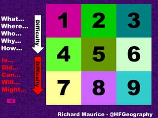
Richard Maurice's #TMRGS presentation on developing questioning
- 1. 1 2 3 4 5 6 7 8 9 What… Where… Who… Why… How… Is… Did… Can… Will… Might… Richard Maurice - @HFGeography DifficultyDifficulty
- 2. 1 What… Where… Who… Why… How… Is… Did… Can… Will… Might… Richard Maurice - @HFGeography DifficultyDifficulty
- 3. 2 What… Where… Who… Why… How… Is… Did… Can… Will… Might… Richard Maurice - @HFGeography DifficultyDifficulty
- 4. 3 What… Where… Who… Why… How… Is… Did… Can… Will… Might… Richard Maurice - @HFGeography DifficultyDifficulty
- 5. 4 What… Where… Who… Why… How… Is… Did… Can… Will… Might… Richard Maurice - @HFGeography DifficultyDifficulty
- 6. 5 What… Where… Who… Why… How… Is… Did… Can… Will… Might… Richard Maurice - @HFGeography DifficultyDifficulty
- 7. 6 What… Where… Who… Why… How… Is… Did… Can… Will… Might… Richard Maurice - @HFGeography DifficultyDifficulty
- 8. 7 What… Where… Who… Why… How… Is… Did… Can… Will… Might… Richard Maurice - @HFGeography DifficultyDifficulty
- 9. 8 What… Where… Who… Why… How… Is… Did… Can… Will… Might… Richard Maurice - @HFGeography DifficultyDifficulty
- 10. 9 What… Where… Who… Why… How… Is… Did… Can… Will… Might… Richard Maurice - @HFGeography DifficultyDifficulty
- 11. Richard Maurice - @HFGeography
- 12. Richard Maurice - @HFGeography
- 13. Adapted from `the nine number picture board’ on: http://www.sln.org.uk/geography/visual.htm How could you use differentiated questioning frameworks for other units/year groups?
- 14. Questioning Differentiation Why encourage questioning? Because we want teachers who… •DO want students to become independent learners who are excited about learning •DO want students to think differently •DO want students who say things that make us say “Hmm…I’ve never thought of it that way…” Leat 2001 Context - Geography Unit: Borders – a unit exploring places through borders Year 8 Title: Europe’s boat people Question for learning: Why is the Mediterranean Europe’s fastest growing grave yard? Richard Maurice - @HFGeography