Downloaded 101 times


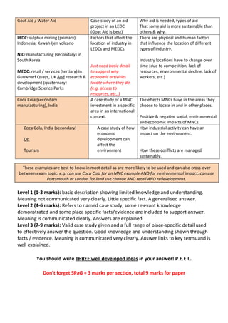
![Exam command words
Command word: What it means
Compare Show similarities and differences. A balanced answer is
required.
Consider Describe and give your thoughts on the subject.
Contrast Point out only the differences between two items.
Define Explain the precise meaning of a concept / word.
Describe Say what something is like, how it works, use adjectives.
Discuss Explain an item or concept, give details about it using evidence/
examples / fact. Give both points of view & come to a
conclusion.
Examine Investigate in detail, offer evidence for and against.
Explain Offer a detailed and exact explanation of an idea or principle.
Identify / State Express the relevant points briefly and clearly.
Illustrate Provide examples to demonstrate or prove a subject.
Justify Give reasons to support your answer / argument, and the main
objections
Summarise / Outline Provide a short summary of all the info on a subject
It might be useful to underline command words in an exam question.
Answering the questions…..
[1mark] questions = can be answered with a single word or simple sentence, often using
data or fact. E.g. Name a climatic hazard = drought [1]
[2mark] questions = either needs two simple sentences, often using data OR needs one
point then explained. E.g. Explain why LEDCs have a higher death rate = poor healthcare
leading to diseases [P] and a lack of food [P] [2] OR LEDCs have a higher death rate
due to a lack of medicine [P] and healthcare which means they cannot treat illnesses
and disease so die more easily [E] [2]
[4mark] questions = requires you to explain, compare, consider evidence, use facts,
refer to examples. The answer should be detailed. You should probably describe and
explain using P.E.E.L. E.g. Using the sources, suggest how afforestation may affect river
flow= Afforestation is the planting of trees / vegetation [P], which can reduce river
volume and increase the lag time as seen on the hydrograph at Point A [Ev]. This is
because vegetation increases interception which reduces surface runoff [Ex] and
therefore the amount of water entering the river and how quickly it gets there will be
reduced [L]. [4]](https://image.slidesharecdn.com/checklist2016-151112210101-lva1-app6891/85/Checklist-2016-OCR-B-GCSE-specification-2-320.jpg)


Afforestation can affect river flow in 3 ways: (1) Trees intercept rainfall which reduces surface runoff entering rivers. (2) Vegetation increases lag time as seen on hydrographs, slowing river volume. (3) Less water enters rivers and reaches them more slowly due to interception and reduced surface runoff from vegetation.


