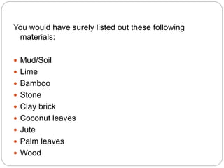
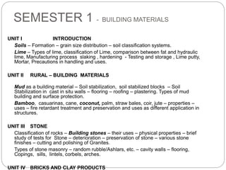
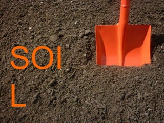
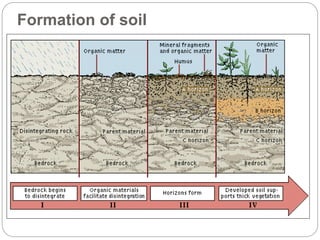
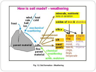
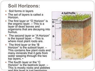
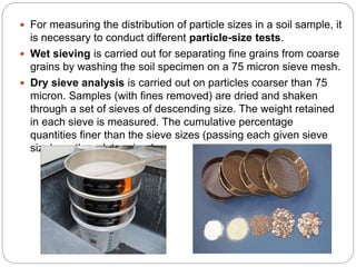
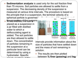
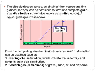
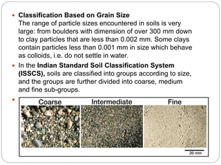
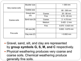
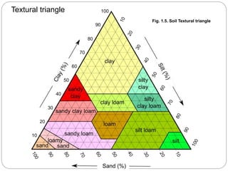
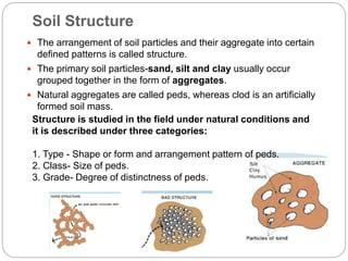
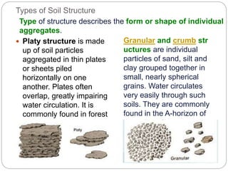
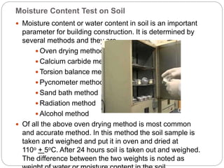
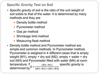
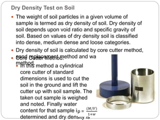
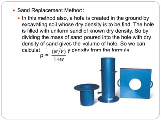
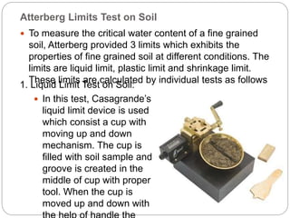
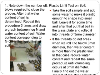
2. ACTIVITY 1
Draw a typical village house that would have been
constructed before independence.
Mention the area in which it would have been constructed
Label the parts of the building mentioning the
Materials used for the same.
Duration 10 mins
3. You would have surely listed out these following
materials:
Mud/Soil
Lime
Bamboo
Stone
Clay brick
Coconut leaves
Jute
Palm leaves
Wood
4. SEMESTER 1 - BUILDING MATERIALS
UNIT I INTRODUCTION
Soils – Formation – grain size distribution – soil classification systems.
Lime – Types of lime, classification of Lime, comparison between fat and hydraulic
lime, Manufacturing process slaking , hardening - Testing and storage , Lime putty,
Mortar, Precautions in handling and uses.
UNIT II RURAL – BUILDING MATERIALS
Mud as a building material – Soil stabilization, soil stabilized blocks – Soil
Stabilization in cast in situ walls – flooring – roofing – plastering. Types of mud
building and surface protection.
Bamboo, casuarinas, cane, coconut, palm, straw bales, coir, jute – properties –
uses – fire retardant treatment and preservation and uses as different application in
structures.
UNIT III STONE
Classification of rocks – Building stones – their uses – physical properties – brief
study of tests for Stone – deterioration – preservation of stone – various stone
finishes – cutting and polishing of Granites.
Types of stone masonry – random rubble/Ashlars, etc. – cavity walls – flooring,
Copings, sills, lintels, corbels, arches.
UNIT IV BRICKS AND CLAY PRODUCTS
6. What is soil?
Soil is a mixture of weathered rock and decayed
plant and animal matter that formed over a long
time.
The types of soil that form depend on many factors.
Climate
Type of bedrock
Shape of the land
Amount of humus
Amount of time
Amount of water
For example, the soil in the desert is different from
the soil in a rainforest. Or clay is different from
farming soil.
10. Soil Horizons:
Soil forms in layers
The set of layers is called a
Horizon.
The first layer or “O Horizon” is
the organic layer. – This is a
layer of dead leaves and
organisms that are decaying into
humus.
The second layer or “A Horizon”
is the topsoil layer. – This is
where most plant roots are.
The third layer or the “B
Horizon” is the subsoil layer. –
This contains few plant roots and
many minerals that it gets from
water seeping through the two
top layers. •
The fourth layer or the “C
Horizon” is the bedrock layer. –
This is mostly rocks and pebbles
11. SOIL CLASSIFICATION SYSTEMS
Classification of soil is the separation of soil into
classes or groups each having similar
characteristics and potentially similar behaviour. A
classification for engineering purposes should be
based mainly on mechanical properties:
permeability, stiffness, strength. The class to which
a soil belongs can be used in its description.
The aim of a classification system is to establish a
set of conditions which will allow useful
comparisons to be made between different soils.
The system must be simple. The relevant criteria
for classifying soils are the size distribution of
particles and the plasticity of the soil.
12. For measuring the distribution of particle sizes in a soil sample, it
is necessary to conduct different particle-size tests.
Wet sieving is carried out for separating fine grains from coarse
grains by washing the soil specimen on a 75 micron sieve mesh.
Dry sieve analysis is carried out on particles coarser than 75
micron. Samples (with fines removed) are dried and shaken
through a set of sieves of descending size. The weight retained
in each sieve is measured. The cumulative percentage
quantities finer than the sieve sizes (passing each given sieve
size) are then determined.
13. Sedimentation analysis is used only for the soil fraction finer
than 75 microns. Soil particles are allowed to settle from a
suspension. The decreasing density of the suspension is
measured at various time intervals. The procedure is based on
the principle that in a suspension, the terminal velocity of a
spherical particle is governed by the diameter of the particle and
the properties of the suspension. In this method, the soil is
placed as a suspension in
a jar filled with distilled
water to which a
deflocculating agent is
added. The soil particles
are then allowed to settle
down. The concentration
of particles remaining in
the suspension at a
particular level can be
determined by using a
hydrometer. Specific
intervals provide information about the
size of particles that have settled down
and the mass of soil remaining in
solution.
The results are then plotted
between % finer (passing) and log
14. The size distribution curves, as obtained from coarse and fine
grained portions, can be combined to form one complete grain-
size distribution curve (also known as grading curve). A
typical grading curve is shown.
From the complete grain-size distribution curve, useful information
can be obtained such as:
1. Grading characteristics, which indicate the uniformity and
range in grain-size distribution.
2. Percentages (or fractions) of gravel, sand, silt and clay-size.
15. Classification Based on Grain Size
The range of particle sizes encountered in soils is very
large: from boulders with dimension of over 300 mm down
to clay particles that are less than 0.002 mm. Some clays
contain particles less than 0.001 mm in size which behave
as colloids, i.e. do not settle in water.
In the Indian Standard Soil Classification System
(ISSCS), soils are classified into groups according to size,
and the groups are further divided into coarse, medium
and fine sub-groups.
The grain-size range is used as the basis for grouping soil
particles into boulder, cobble, gravel, sand, silt or clay
16. Very coarse soils
Boulder size > 300 mm
Cobble size 80 - 300 mm
Coarse soils
Gravel size
(G)
Coarse 20 - 80 mm
Fine 4.75 - 20 mm
Sand size (S) Coarse 2 - 4.75 mm
Medium 0.425 - 2 mm
Fine 0.075 - 0.425 mm
Fine soils
Silt size (M) 0.002 - 0.075 mm
Clay size (C) < 0.002 mm
Gravel, sand, silt, and clay are represented
by group symbols G, S, M, and C respectively.
Physical weathering produces very coarse and
coarse soils. Chemical weathering produce
generally fine soils.
18. Soil Structure
The arrangement of soil particles and their aggregate into certain
defined patterns is called structure.
The primary soil particles-sand, silt and clay usually occur
grouped together in the form of aggregates.
Natural aggregates are called peds, whereas clod is an artificially
formed soil mass.
Structure is studied in the field under natural conditions and
it is described under three categories:
1. Type - Shape or form and arrangement pattern of peds.
2. Class- Size of peds.
3. Grade- Degree of distinctness of peds.
19. Types of Soil Structure
Platy structure is made
up of soil particles
aggregated in thin plates
or sheets piled
horizontally on one
another. Plates often
overlap, greatly impairing
water circulation. It is
commonly found in forest
soils, in part of the A-
horizon, and
in claypan*soils.
Granular and crumb str
uctures are individual
particles of sand, silt and
clay grouped together in
small, nearly spherical
grains. Water circulates
very easily through such
soils. They are commonly
found in the A-horizon of
the soil profile.
Type of structure describes the form or shape of individual
aggregates.
20. Prismatic and
columnar
structures are soil
particles which have
formed into vertical
columns or pillars
separated by miniature,
but definite, vertical
cracks. Water
circulates with greater
difficulty and drainage
is poor. They are
commonly found in the
B-horizon where clay
has accumulated;
Blocky and subangular
blocky structures are soil
particles that cling together
in nearly square or angular
blocks having more or less
sharp edges. Relatively large
blocks indicate that the soil
resists penetration and
movement of water. They
are commonly found in the
B-horizon where clay has
accumulated;
21. Classes of Soil Structure
Class of structure describes the average size of individual
aggregates. Usually, five distinct classes may be
recognized in relation to the type of soil structure from which
they come. They are:
Very fine or very thin;
Fine or thin;
Medium;
Coarse or thick;
Very coarse or very thick.
The terms thin and thick are used for platy types, while the
terms fine and coarse are used for other structural types.
22. Grade of Soil Structure:
The grade of structure is the degree of aggregation.
1. Structure-less:
There are no noticeable peds, such as conditions
exhibited by loose sand or a cement-like condition of
some clay soils.
2. Weak structure:
Indistinct formation of peds which are not durable.
3. Moderate structure:
Moderately well-developed peds which are fairly distinct.
4. Strong structure:
Very well-formed peds which are quite durable and
distinct.
23. Tests on soil :
Types of Soil tests for building construction works
depend on properties of soil. Design of foundation
is based on soil test report of construction site.
Various tests on soil are conducted to decide the
quality of soil for building construction. Some
tests are conducted in laboratory and some are in
the field.
The tests on soil are as follows.
Moisture content test
Specific gravity of soil
Dry density of soil
Atterberg limits tests
Compaction test (Proctor’s test)
24. Moisture Content Test on Soil
Moisture content or water content in soil is an important
parameter for building construction. It is determined by
several methods and they are
Oven drying method
Calcium carbide method
Torsion balance method
Pycnometer method
Sand bath method
Radiation method
Alcohol method
Of all the above oven drying method is most common
and accurate method. In this method the soil sample is
taken and weighed and put it in oven and dried at
110o + 5oC. After 24 hours soil is taken out and weighed.
The difference between the two weights is noted as
25. Specific Gravity Test on Soil
Specific gravity of soil is the ratio of the unit weight of
soil solids to that of the water. It is determined by many
methods and they are
Density bottle method
Pycnometer method
Gas jar method
Shrinkage limit method
Measuring flask method
Density bottle method and Pycnometer method are
simple and common methods. In Pycnometer method,
Pycnometer is weighed in 4 different cases that is empty
weight (M1), empty + dry soil (M2), empty + water + dry
soil (M3) and Pycnometer filled with water (M4) at room
temperature. From these 4 masses specific gravity is
determined by below formula.
26. Dry Density Test on Soil
The weight of soil particles in a given volume of
sample is termed as dry density of soil. Dry density of
soil depends upon void ratio and specific gravity of
soil. Based on values of dry density soil is classified
into dense, medium dense and loose categories.
Dry density of soil is calculated by core cutter method,
sand replacement method and water-displacement
method.
Core Cutter Method:
In this method a cylindrical
core cutter of standard
dimensions is used to cut the
soil in the ground and lift the
cutter up with soil sample. The
taken out sample is weighed
and noted. Finally water
content for that sample is
determined and dry density is
27. Sand Replacement Method:
In this method also, a hole is created in the ground by
excavating soil whose dry density is to be find. The hole
is filled with uniform sand of known dry density. So by
dividing the mass of sand poured into the hole with dry
density of sand gives the volume of hole. So we can
calculate the soil dry density from the formula
28. Atterberg Limits Test on Soil
To measure the critical water content of a fine grained
soil, Atterberg provided 3 limits which exhibits the
properties of fine grained soil at different conditions. The
limits are liquid limit, plastic limit and shrinkage limit.
These limits are calculated by individual tests as follows
1. Liquid Limit Test on Soil:
In this test, Casagrande’s
liquid limit device is used
which consist a cup with
moving up and down
mechanism. The cup is
filled with soil sample and
groove is created in the
middle of cup with proper
tool. When the cup is
moved up and down with
29. 2. Plastic Limit Test on Soil:
Take the soil sample and add
some water to make it plastic
enough to shape into small
ball. Leave it for some time
and after that put that ball in
the glass plate and rolled it
into threads of 3mm diameter.
If the threads do not break
when we roll it to below 3mm
diameter, then water content
is more than the plastic limit.
In that case reduce water
content and repeat the same
procedure until crumbling
occurs at 3mm diameter.
Finally find out the water
1. Note down the number of
blows required to close the
groove. After that water
content of soil is
determined. Repeat this
procedure 3 times and draw
a graph between log N and
water content of soil. Water
content corresponding to
N=25 is the liquid limit of
soil.
30. 3. Liquid Limit Test on Soil:
In case of shrinkage limit, the water content in the soil
is just sufficient to fill the voids of soil. That is degree
of saturation is of 100%. So, there is no change in
volume of soil if we reduce the shrinkage limit. It is
determined by the below formula for the given soil
sample.
Where M1 = initial mass
V1= initial volume
M2= dry mass
V2= volume after drying
Pw = density of water
31. Proctor’s Compaction Test on Soil
Proctor’s test is conducted to determine compaction
characteristics of soil. Compaction of soil is nothing but
reducing air voids in the soil by densification. The degree
of Compaction is measured in terms of dry density of soil
1. In Proctor’s Compaction Test, given soil
sample sieved through 20mm and 4.75 mm
sieves. Percentage passing 4.75mm and
percentage retained on 4.75mm are mixed
with certain proportions.
Add water to it and leave it in air tight
container for 20hrs. Mix the soil and
divide it into 6 – 8 parts. Position the
mold and pour one part of soil into the
mold as 3layers with 25 blows of
ramming for each layer.
32. Remove the base plate and Weight the soil along with
mold. Remove the soil from mold and take the small
portion of soil sample at different layers and conduct
water content test. from the values find out the dry
density of soil and water content and draw a graph
between them and note down the maximum dry density
and optimum water content of the compacted soil sample
at highest point on the curve.