Araling Panlipunan 4
Ekonomiks Learning Module Yunit 1
------------------
Source: DepEd
Regional Mass Training for Grade 10 Teachers on K to 12 Basic Education Program
May 4 - 9, 2015 | Bicol University, Daraga, Albay
This document is a book titled "5-Minute Daily Practice: Geography" by Minnie Ashcroft. It contains 180 five-minute geography activities organized around the five fundamental themes of geography: location, place, human-environment interaction, movement, and regions. The introduction explains how the activities can be used for daily practice and reinforcement of geography skills. It also provides a table correlating the five themes to the six elements of geography from the National Geography Standards.
This presentation outlines a unit plan on Lewis and Clark's expedition that will last approximately two weeks. The unit aims to teach students about different geographic regions and how knowledge of these regions helped settlers survive. Students will research Lewis and Clark's journey and learn to distinguish physical geographic features. They will answer essential questions about why geographic awareness is important and content questions about regions, supplies, and the expedition's impact. The teacher will provide instruction and support, while students research and are responsible for the learning objectives. A parent role is to ensure students do additional at-home research. The project-based learning approach aims to keep students engaged while covering the same material in an interactive way.
Brittney OkaforSubject Social StudiesLesson TitleLesson # .docxrichardnorman90310
1. The document outlines a lesson plan for a 4th grade social studies class on the history of North Carolina from pre-colonial times to Reconstruction.
2. The lesson plan includes objectives, vocabulary, materials, instructional activities, and assessments. It covers topics like Native American tribes, European exploration and colonization, and the impact on indigenous peoples.
3. Students will learn through audio clips, virtual tours, discussions, and a final project where they create a diorama depicting life in early North Carolina colonies.
3. Disciplines and Ideas in the Social DLP2.docxErinRoelle
The document is a daily lesson log for a Grade 12 DISS (Disciplines and Ideas in the Social Sciences) class. It outlines four class periods covering topics on defining social sciences, distinguishing between social sciences and other fields, and introducing key social science disciplines including anthropology, economics, geography, and history. Learning activities include group discussions, presentations, worksheets, and games to help students understand and compare the different social science disciplines.
This document provides a daily lesson log for a 12th grade Understanding Culture, Society, and Politics class. Over the course of a week, students will learn about defining and understanding culture and society from anthropological and sociological perspectives. They will discuss topics like cultural relativism, ethnocentrism, cultural heritage, and threats to culture. Learning activities include group discussions, presentations, essays, and role-playing skits. The goal is for students to develop an appreciation of different cultures without judgment and to understand the complex relationships between culture and society.
This document outlines the daily lesson log for a Grade 11 Humanities class. Over the course of a week, the class will learn about the emergence of social sciences and the different disciplines within social sciences. They will compare and contrast the various social science disciplines, distinguish social sciences from natural sciences and humanities, and be introduced to the disciplines of anthropology, economics, geography, and history. A variety of activities are planned, including discussions, analysis of pictures and graphs, interactive games, and self-reflection exercises to help students develop their understanding of these concepts.
This document is a daily lesson log for an Earth and Life Science class at Tanglag National High School. It outlines the topics, learning competencies, and lesson plans for a week. The topics covered include the origin and structure of the Earth, the universe and solar system. Learning activities include lectures, videos, debates and a quiz. The objective is for students to understand concepts like the formation of the universe, properties of Earth and other planets, and factors that allow life.
1) The document outlines a detailed lesson plan for a Grade 10 Science class about the composition of the Earth's interior, specifically focusing on the crust.
2) Key objectives are for students to explain plate tectonic processes, describe effects of plate movement, and understand the value of plate movement effects.
3) The lesson plan involves recall, motivation, and group activities to learn about the two types of crust - continental and oceanic. The continental crust is thicker and less dense, found under land, and mainly composed of elements like silicon and oxygen. The oceanic crust is thinner, denser, under oceans, and contains elements like iron and magnesium.
This unit plan outlines a week-long lesson for 4th grade students on European exploration and colonial America, utilizing various technologies, hands-on activities like group projects and games, and assessments including worksheets, quizzes and a final test. The plan details the objectives to be covered each day, the media and materials to be used, how student participation will be engaged, and how student learning will be evaluated and the unit revised if needed.
This unit plan outlines a week-long lesson for 4th grade students on European exploration and colonial America. It includes objectives aligned to state standards, lists materials and websites to utilize, provides a daily schedule of activities involving maps, timelines, group projects, and interactive games/worksheets to engage students. Student learning will be evaluated through daily participation, group presentations, quizzes and a final assessment at the end of the unit.
This document outlines a three-week unit plan on the geography of settlements for high school students. In week one, students will be introduced to key vocabulary and learn about the geography of piedmont regions. They will create posters labeling geographical features. Week two focuses on different landforms like valleys and how geography impacts culture. Students will discuss places they find interesting and present on the geography of Europe. Week three involves completing a performance assessment on the culture and geography of a country, presenting myths based on its landscape, and self-assessing their work. The goal is for students to understand relationships between physical and human geography.
This document outlines a three-week unit plan on the geography of settlements for high school students. In week one, students will be introduced to key vocabulary and learn about the geography of piedmont regions. They will create posters labeling geographical features. Week two focuses on different landforms like valleys and how geography impacts culture. Students will analyze places they enjoy and present on the geography of Europe. Week three involves completing a performance assessment on the culture and geography of a country, presenting myths based on its geography, and self-assessing their work. The goal is for students to understand relationships between physical and human geography.
Lesson Plan for Demonstration Teaching.docxssuser429636
The lesson plan summarizes teaching 4th grade students about the rotation of the Earth. The objectives are for students to describe Earth's rotation on its axis, understand the importance of rotation in daily life, and locate different places on a globe. The procedure uses the 5 A's method (Awareness, Activity, Analysis, Abstraction, Application). Students are divided into groups to identify countries experiencing day or night based on rotating a globe with half lit by a flashlight. They then arrange scrabble letters to reinforce key concepts like the axis and 24-hour rotation. For evaluation, students answer questions and draw Earth facing the sun, coloring the day and night sides.
This document outlines a three-week unit plan on the geography of settlements for high school students. The unit is designed using the Understanding by Design framework. It focuses on helping students understand the relationship between physical geography and human culture. Students will learn about key geographical concepts and features through class activities, videos, and a guest speaker. They will apply their knowledge by creating a poster, labeling maps, and developing a performance task on the geography and culture of a European country. The goal is for students to see how geography influences factors like population, trade, and cultural traditions.
This document outlines a three-week unit plan on the geography of settlements for high school students. The unit is designed according to the Understanding by Design framework. It focuses on helping students understand the relationship between physical geography and human culture. Students will learn key geographic concepts and examine how geography influences population patterns, economic development, and customs in different places like Europe and their own region. Assessment includes a performance task, where students research and present on the geography and culture of a country.
The unit introduces students to Mississippi geography through the five themes of geography - location, place, region, human-environment interaction, and movement. On the first day, students define the five themes and provide examples of location, place, and region in Mississippi through group work and presentations. They predict how Mississippi's geography impacts its social and political development. To assess understanding, students complete an independent worksheet and exit ticket connecting Mississippi's geography to its history and people.
Similar to Banghay aralin sa araling panlipunan 8 (20)
How to Add Chatter in the odoo 17 ERP ModuleCeline George
In Odoo, the chatter is like a chat tool that helps you work together on records. You can leave notes and track things, making it easier to talk with your team and partners. Inside chatter, all communication history, activity, and changes will be displayed.
Exploiting Artificial Intelligence for Empowering Researchers and Faculty, In...Dr. Vinod Kumar Kanvaria
Exploiting Artificial Intelligence for Empowering Researchers and Faculty,
International FDP on Fundamentals of Research in Social Sciences
at Integral University, Lucknow, 06.06.2024
By Dr. Vinod Kumar Kanvaria
LAND USE LAND COVER AND NDVI OF MIRZAPUR DISTRICT, UPRAHUL
This Dissertation explores the particular circumstances of Mirzapur, a region located in the
core of India. Mirzapur, with its varied terrains and abundant biodiversity, offers an optimal
environment for investigating the changes in vegetation cover dynamics. Our study utilizes
advanced technologies such as GIS (Geographic Information Systems) and Remote sensing to
analyze the transformations that have taken place over the course of a decade.
The complex relationship between human activities and the environment has been the focus
of extensive research and worry. As the global community grapples with swift urbanization,
population expansion, and economic progress, the effects on natural ecosystems are becoming
more evident. A crucial element of this impact is the alteration of vegetation cover, which plays a
significant role in maintaining the ecological equilibrium of our planet.Land serves as the foundation for all human activities and provides the necessary materials for
these activities. As the most crucial natural resource, its utilization by humans results in different
'Land uses,' which are determined by both human activities and the physical characteristics of the
land.
The utilization of land is impacted by human needs and environmental factors. In countries
like India, rapid population growth and the emphasis on extensive resource exploitation can lead
to significant land degradation, adversely affecting the region's land cover.
Therefore, human intervention has significantly influenced land use patterns over many
centuries, evolving its structure over time and space. In the present era, these changes have
accelerated due to factors such as agriculture and urbanization. Information regarding land use and
cover is essential for various planning and management tasks related to the Earth's surface,
providing crucial environmental data for scientific, resource management, policy purposes, and
diverse human activities.
Accurate understanding of land use and cover is imperative for the development planning
of any area. Consequently, a wide range of professionals, including earth system scientists, land
and water managers, and urban planners, are interested in obtaining data on land use and cover
changes, conversion trends, and other related patterns. The spatial dimensions of land use and
cover support policymakers and scientists in making well-informed decisions, as alterations in
these patterns indicate shifts in economic and social conditions. Monitoring such changes with the
help of Advanced technologies like Remote Sensing and Geographic Information Systems is
crucial for coordinated efforts across different administrative levels. Advanced technologies like
Remote Sensing and Geographic Information Systems
9
Changes in vegetation cover refer to variations in the distribution, composition, and overall
structure of plant communities across different temporal and spatial scales. These changes can
occur natural.
How to Setup Warehouse & Location in Odoo 17 InventoryCeline George
In this slide, we'll explore how to set up warehouses and locations in Odoo 17 Inventory. This will help us manage our stock effectively, track inventory levels, and streamline warehouse operations.
A workshop hosted by the South African Journal of Science aimed at postgraduate students and early career researchers with little or no experience in writing and publishing journal articles.
How to Manage Your Lost Opportunities in Odoo 17 CRMCeline George
Odoo 17 CRM allows us to track why we lose sales opportunities with "Lost Reasons." This helps analyze our sales process and identify areas for improvement. Here's how to configure lost reasons in Odoo 17 CRM
Walmart Business+ and Spark Good for Nonprofits.pdfTechSoup
"Learn about all the ways Walmart supports nonprofit organizations.
You will hear from Liz Willett, the Head of Nonprofits, and hear about what Walmart is doing to help nonprofits, including Walmart Business and Spark Good. Walmart Business+ is a new offer for nonprofits that offers discounts and also streamlines nonprofits order and expense tracking, saving time and money.
The webinar may also give some examples on how nonprofits can best leverage Walmart Business+.
The event will cover the following::
Walmart Business + (https://business.walmart.com/plus) is a new shopping experience for nonprofits, schools, and local business customers that connects an exclusive online shopping experience to stores. Benefits include free delivery and shipping, a 'Spend Analytics” feature, special discounts, deals and tax-exempt shopping.
Special TechSoup offer for a free 180 days membership, and up to $150 in discounts on eligible orders.
Spark Good (walmart.com/sparkgood) is a charitable platform that enables nonprofits to receive donations directly from customers and associates.
Answers about how you can do more with Walmart!"
it describes the bony anatomy including the femoral head , acetabulum, labrum . also discusses the capsule , ligaments . muscle that act on the hip joint and the range of motion are outlined. factors affecting hip joint stability and weight transmission through the joint are summarized.
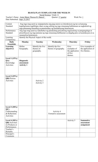
1. BLOCK PLAN TEMPLATE FOR THE WEEK IN
Social Science Grade: 8
Teacher’s Name : Arnie Marie Therese R. Dancel Quarter: 1st
quarter Week No: 1
Date Submitted.: Sept. 21,2017
Content
Standard
Ang mga mag-aaral ay naipapamalas ang pag-unawa sa interaksiyon ng tao sa kanyang
kapaligiranna nagbibigay daan sa pag-usbong ng mga sinaunang kabihasnan na nagkaloob ng
mga pamanang humubog sa pamumuhay ng kasalukuyang henerasyon.
Performance
Standard
Ang mga mag-aaral ay nakabubuo ng panukalang proyektong nagsusulong sa pangangalaga at
preserbasyon ng mga pamana ng mga sinaunang kabihasnan sa daigdig para sa kasalukuyan at sa
susunod na henerasyon.
Learning
Competency
Identify the Physical Aspect of the world.
Daily
Essentials
Monday Tuesday Wednesday Thursday Friday
Learning
objectives
Define
Geography.
Identify the five
themes of
geography.
Identify the five
themes of geography.
Give
examples of
the application
of five
themes.
Give examples of
the application of
five themes..
Level 1 (15%)
QA)
Knowledge
Activities
Diagnostic
assessment
Activity 1
Level 2 (25%)
QB) Process
Activities Activity 2
Activity 3
Level 3 (30%)
QC)
Understanding
& Reflections
Activities
Activity 4
Formative assessment
Level 4 (30%)
QB) Activities
on Products or
Performances
Activity 5 Summative
assessment
assignment
Teacher’s
Remarks
Principal’s
Comments
2. DESIRED LEARNING ACTIVITIES (DLA) TEMPLATE
DLA No. 1 Subject: Social Science Grade Level: Grade-8
Learning Competency: Identify the Physical aspect of the world.
Lesson/s: World Geography
Objectives: a.) Define Geography.
b.) identify the five themes of geography.
c.) give examples of application of the five themes.
Worksheet No. 1.Diagnostic Assessment
Direction: Answer what is asked below. Write your answer in a ¼ sheet of paper.
Write 5 questions about the place you have never visited.
Example:
1. Where is Korea?
2. What are the different tourist spots in Korea?
3. Is Seoul part in Korea?
The students will share their answers.
Assignment: Direction: Answer your own questions about the place you’ve never been.
I. Getting to Know the Lesson (Knowledge)
Activity 1: Defining Geography
Direction: Using the data that you’ve collected, answer the question below:
For you, what is geography?
The students will share their own definition of geography.
The teacher will elaborate and give the definition of geography as a class.
II. Skill Development (Process)
Activity 2:
a) The teacher will write the following questions on the board:
1. How many professional sports teams does San Francisco have?
2. How did the invention of the refrigerated train can affect farmers?
3. Why is Texas among the fast-growing states?
4. Is Cebu part of Region VII?
b) The teacher will asks the students the question below:
Which of the questions is a geographic question?
c) Using the questions above, the teacher will introduce the Five Themes of Geography.
Activity 3:
Using the questions above, the teacher will ask the following questions below:
What theme is linked to question number 1?
What theme is linked to question number 2?
What theme is linked to question number 3?
What theme is linked to question number 4?
III. Constructing Meanings (Understanding and Reflections)
Activity 4:
After knowing the five themes in geography, the teacher will ask the following questions:
For you what is a location based on the activity?
For you what is a place based on the activity?
For you what is an interaction based on the activity?
3. For you what is a movement based on the activity?
For you what is a region based on the activity?
Formative Assessment:
Direction: Identify what theme/s of geography is present in each post card below. Write your
answer on the space provided.
OMG! I’m having an amazing time in New York. I
have visited beautiful lakes and gorgeous mountains.
We then went to the south and road subway which
cuts right under the city! We went to Ellis island
today and learned all about how New York has such
a diverse population because about 25 million
immigrants entered United States from here. Wish
you were here!
POST CARD 1
After driving all night we have finally arrived in
Atlanta (33.7849 degrees North, 84.3900 degrees
West). It is hot here so hot some people call it
Hotlanta! Being from the North I find it so interesting
that almost everyone here speaks southern accent. It
is so much different from New England! Can’t wait
to see you again.
POST CARD 2
Hello there I am writing for you from fabulous Los
Angeles California. There are sooo many people
here. I made some research and find out that it is the
most populated place in United States. So many of
these people are not from California; they travelled
from all over the whole world to come here to to try
to be successful in entertainment industry. Los
Angeles lies south of San Francisco. Cool huh? Can’t
wait to go to the beach!
POST CARD 3
We are having an amazing time taking our road trip
to New England. Although there are six different
states, they are all connected by similar historical
background. Most of New England was founded by
British colonist. Since it is January and really cold
here, people tend to wear a lot of layers and even
their roofs are slanted so the snow falls off. The
region of New England is located east of New York
State. While we’re here, I think I’m going to go
skiing!
POST CARD 4
ANSWER KEY:
Postcard 1:
Gorgeous lakes and mountains – place
Subway which cuts right under the city – human and environment interaction
Ellis Island – movement
Post card 2:
Atlanta (33.7849 degrees North, 84.3900 degrees West). – location
The heat – place
Southern accent – region
4. Post card 3:
Population of Los Angeles – place
People come to LA for the entertainment industry – movement
Los Angeles south of San Francisco – location
Post card 4:
Similar history – region
Layers and slanted roofs – human and environment interaction
East of New York - location
IV. Learning Transfer (Products or Performances)
Activity 5: Speech
A. The teacher will group the students into five. The group will be given different module depending on
what theme of geography they are going to be assigned to. The first group will be assigned to talk about
location; the second group will be assigned to talk about place; the third group will be assigned to talk
about interaction; the fourth group will be assigned to talk about movement; the last group will be
assigned to talk about region.
B. The group will be having a brainstorming on what they are going to speak about their assigned themes
of geography. The brainstorming will be given in 10 minutes to finish and the speech will be given 3-5
minutes.
C. The teacher will randomly select a speaker of the group to talk about the assigned theme of geography.
Each group will be given 40 points using the rubric below:
Content – 5
Delivery – 10
Mastery – 10
Overall – 15
Total - 40
SUMMATIVE ASSESSMENT:
PHYSICAL CHARACTERISTICS OF YOUR REGION:
DIRECTION: Using the table below describe your own region.
(Region)
Location place Human and nature
interaction
movement
Absolute:
Relative:
Land forms:
Water forms:
ASSIGNMENT:
SCRAPBOOK
The students will make a scrapbook about the student’s community. The scrapbook must contain the five
themes of geography. The students will describe their community using the five themes of geography.