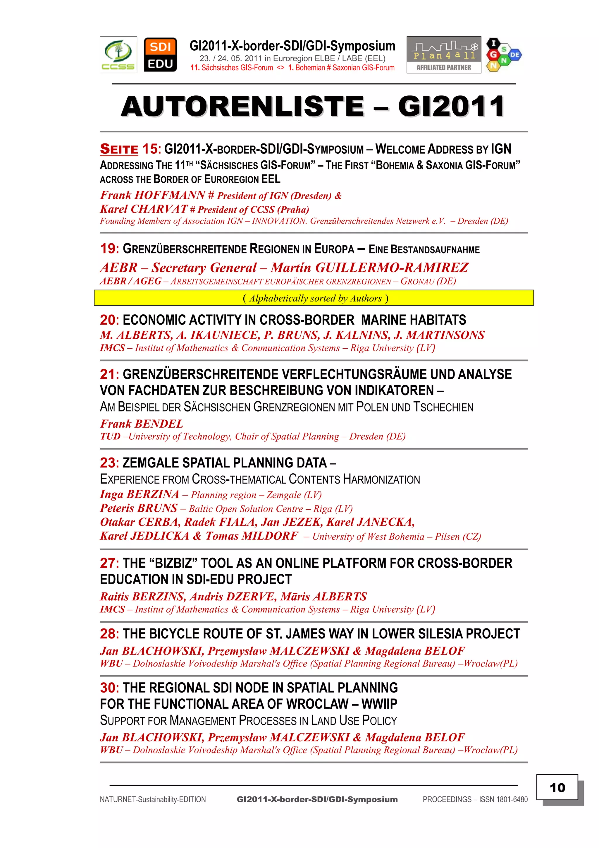
Downloaded 19 times
![GI2011-X-border-SDI/GDI-Symposium
23. / 24. 05. 2011 in Euroregion ELBE / LABE (EEL)
11. Sächsisches GIS-Forum <> 1. Bohemian # Saxonian GIS-Forum
________________________________________________________________________________________
This event has been supported by European Commission (EU-Programme “Inter-regional Collaboration”) in Free State of Saxony (2007-2013)
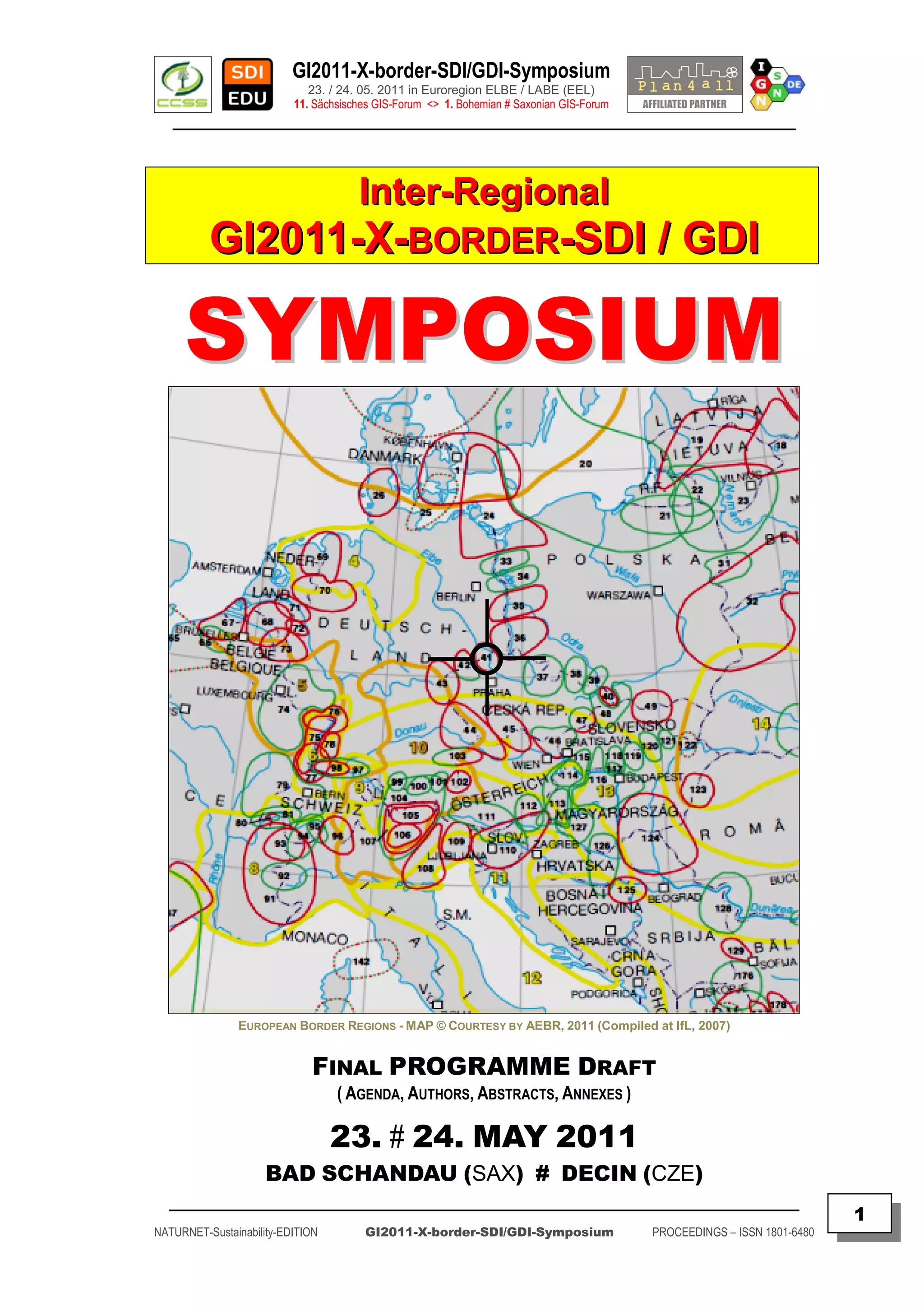
EUROPEAN BORDER REGIONS
"GeoINSPIRE'd X-border-SDI/GDI for Digital Europe 2020"
SUSTAINABILITY OF INTER-REGIONAL COLLABORATION
The GeoINSPIRE'd Main FOCUS of GI2011
is about X-border-GI/GIS/GDI-Awareness, Innovation & Research on
X-PSI / X-INSPIRE – Data, Service and “Best Practices”
of GEO-ENVIRO-SPATIO-Applications
towards INSPIRE'd Geoportals4Everybody !
PROGRAMME COMMITTEE:
MEMBERS OF PROGRAMME & ORG COMMITTEE:
Dr. J. BLACHOWSKI (PL), Dr. K. CHARVAT (CZ), C. CORBIN (UK), Dr. J. FURDIK (SK), Dr. K. JANECKA (CZ),
Dr. P. KUBICEK (CZ), Dipl.Ing. W. MAYER (AT), Dipl.Ing.Tomas MILDORF(CZ), J.THURSTON (CA).
Doz. Dr. F. HOFFMANN (DE), Prof. Dr. S. KLOSS (DE), Dr. K.-D. MICHAEL (DE), Prof. Dr. I.ROCH (DE).
REFERENCE INFORMATION & INTERNET URL‟S:
CCSS-Praha [ http://www.CCSS.cz ]
IGN-Dresden [ http://GDI-SN.blogspot.com ]
UWB-Plzen [ http://www.PLAN4ALL.eu ] + [ http://www.SDI-EDU.zcu.cz ]
SOCIAL NETWORKS [ INSPIRE-FORUM ] + [ FACEBOOK ] + [ LINKEDIN ] + [ TWITTER ]
IMPRESSUM:
Herausgegeben von / Published by
Founding Members of IGN e.V.:
Doz. Dr. Frank HOFFMANN, CSc
IGN – Vorstandsvorsitzender, Dresden
INNOVATION. Grenzüberschreitendes Netzwerk e.V.
Dr. Karel CHARVAT
CCSS – President, Praha
Czech Center for Science and Society
INNOVATION. Grenzüberschreitendes Netzwerk
( Gemeinnütziger e.V. / Non-profit Organization )
c/o IGN-Vorstand, Martin-Andersen-Nexö-Str. 4
D – 01217 DRESDEN / Saxony / Germany
SKYPE: [ fh_ign ]
INTERNET: [ http://www.IGN-SN.de ]
WEBLOG: [ http://www.GDI-SN.de ]
EMAIL: [ info@GDI-SN.de | Vorstand@IGN-SN.de ]
TEL/FAX: [ +49-351-403.2729 # FAX: +49-351-401.4260 ]
Copyright © 2011 – CCSS-Praha & IGN-Dresden & UWB-Plzen – All rights reserved.
_________________________________________________________________________________________
2
NATURNET-Sustainability-EDITION GI2011-X-border-SDI/GDI-Symposium PROCEEDINGS – ISSN 1801-6480](https://image.slidesharecdn.com/gi2011proceedingsv5final-110705072117-phpapp02/75/GI2011-proceedings-v5-final-2-2048.jpg)
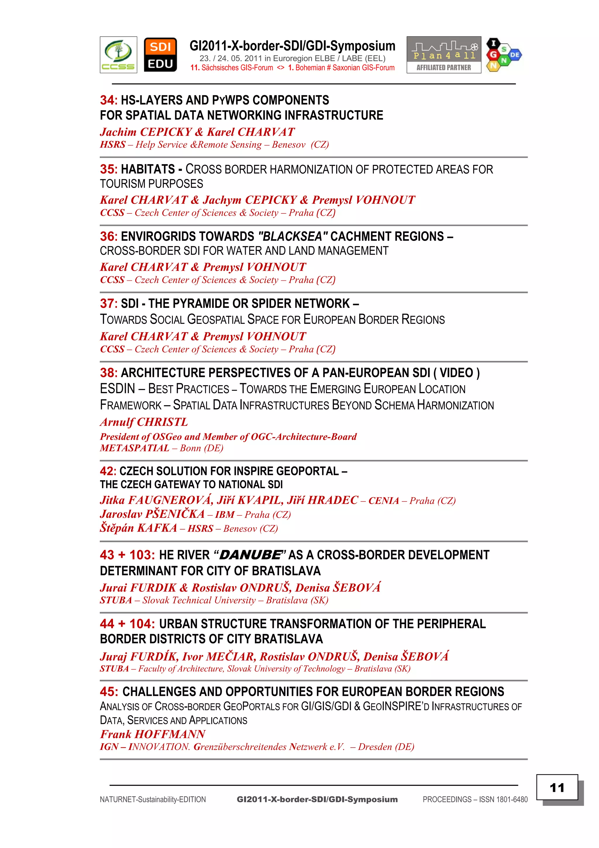
![GI2011-X-border-SDI/GDI-Symposium
23. / 24. 05. 2011 in Euroregion ELBE / LABE (EEL)
11. Sächsisches GIS-Forum <> 1. Bohemian # Saxonian GIS-Forum
________________________________________________________________________________________
GI2011 – CROSS-BORDER – SDI/GDI – SYMPOSIUM FOR
EUROPEAN BORDER REGIONS – 23./24. MAY 2011
TOWARDS GEOINSPIRE'D X-BORDER-SDI/GDI FOR EUROPEAN BORDER REGIONS IN
DIGITAL EUROPE 2020 !
IGN, CCSS and UniWB are organizing this professional event, following their long-time education and
research activities to achieve better SDI/GDI awareness and closer cooperation in EUROPEAN BORDER REGIONS to
adapt to the EU Strategy of “Europe 2020” and the Action Plan “Digital Europe 2020”. The EU Directives on re-using
of Public Sector Information (PSI) and development of Infrastructures for Spatial Information in Europe (INSPIRE)
are strategic opportunities and challenges for more than 200 EUROPEAN BORDER REGIONS.
Therefore, you are welcome to participate at this GI2011-X-border-SDI/GDI Symposium to be held as
the “11th Sächsisches GIS-Forum” at May 23rd in BAD SCHANDAU (SAX) & “1st Bohemia # Saxonia GIS-Forum” at May
24th in DECIN (CZE). Both these GI2011 events should inform on the progress of EU-Directives PSI for re-using public
sector information, as well as on INSPIRE about interoperability of X-border Data, Services & Applications, especially
in EUROPEAN BORDER REGIONS.
The GI2011-X-border-SDI/GDI Symposium is presenting existing and still yet developing cross-border
SDI/GDI Geoportal solutions to demonstrate the transformation, harmonization and integration processes of
independent WebGIS-Portals into more complex SDI/GDI Frameworks. The importance of the “borderless”
OpenStreetMap (OSM) will be highlighted too !
Examples of the very few existing cross-border Geoportals should have been presented like DP-PLIS,
REGIOGDI-BE/BB, REGIOGDI-MRH, X-GDI-RONDUIT, REGIOGDI-RKN, GIS-GRANDEREGION, SIGRS/GISOR,
DACH+, CENTROPE-Map/Statistics, REGIOCxD, as well as the less known developing SDI„s from other EUROPEAN
BORDER REGIONS now focusing on INSPIRE principles, but unfortunately, not all of these border regions have used
the opportunity to present lessons learned and strategies developed. Nevertheless, the presentation of National
Czech INSPIRE Geoportal will be one of the highlights of the GI2011 Symposium !
The Goal of GI2011 Symposium is to share information, knowledge, and expertise, to learn from SDI
and OSM „best practices“, as well as to exchange and discuss European awareness and research projects
(NATURNET, SDI-EDU, HUMBOLDT) and other European networks (GEOPORTAL4EVERYBODY, PLAN4ALL, etc.)
introducing innovative geomatics technologies, demonstrating cost-benefit approaches, as well as discussing the
frameworks for PSI, GI & SDI policy, organization and technologies behind the INSPIRE process.
The GI2011-X-border-SDI/GDI-Symposium has its focus as well on actual EU research projects and “best
practice” networks like ESDIN (EuroGeographics et al.), GEOPORTAL4EVERYBODY (CCSS & UNSDI.cz), PLAN4ALL
(UWB & CCSS), and SDI-EDU (UWB) to share the experience and advanced knowledge directly with participants
registered from local and regional organizations in EUROPEAN BORDER REGIONS. The GI2011-Participants will
share a „Round Table Discussion Session“ on PSI & INSPIRE challenges important for border regions.
The Locations of GI2011-Symposium are situated in the Center of the Euroregion „Elbe # Labe“ (EEL),
at the first day to be held in Bad Schandau (SAX), and at the second day in Decin (CZE), both located in the Cross-
border National Park Region of "Bohemia # Saxonia Switzerland". The first day ends with an INVITATION to a
SOCIAL EVENING taking place as “Get together @ Lounge Room” in Restaurant of “Hotel Posta” at Decin City Center.
An Exhibition at Castle Decin is informing about [ Eger border treaty between Bohemia and Saxonia ]
more than 550 years ago signed in Eger (Cheb) between Bohemia and Saxonia in year 1459.
The [ Interactive Historical Map ] was developed as a X-border-Exhibition-Project [ „GRENZRÄUME“ ]
in the Euroregion EEL which is open for visiting at both [ Castle Weesenstein (SAX) ] and [ Castle Decin (CZE) ].
Dresden & Praha and Plzen: April 23rd , 2011
IGN e.V. (Dresden) # CCSS (Praha) & UniWB (Plzen)
_________________________________________________________________________________________
4
NATURNET-Sustainability-EDITION GI2011-X-border-SDI/GDI-Symposium PROCEEDINGS – ISSN 1801-6480](https://image.slidesharecdn.com/gi2011proceedingsv5final-110705072117-phpapp02/75/GI2011-proceedings-v5-final-4-2048.jpg)
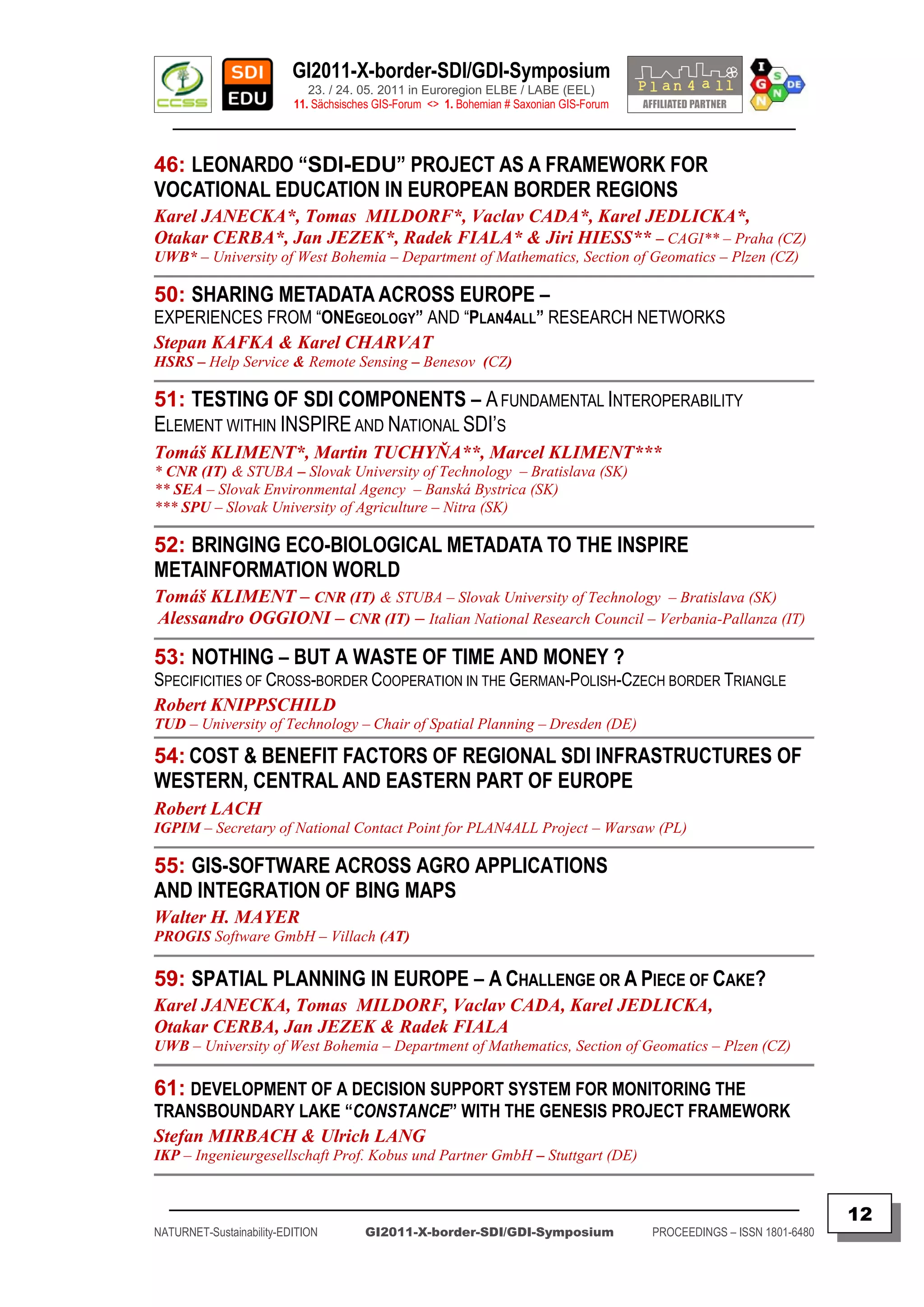
![GI2011-X-border-SDI/GDI-Symposium
23. / 24. 05. 2011 in Euroregion ELBE / LABE (EEL)
11. Sächsisches GIS-Forum <> 1. Bohemian # Saxonian GIS-Forum
________________________________________________________________________________________
GI2011 – RAHMENPROGRAMM - AGENDA
Interactive Agenda: Bad Schandau (23.05.2011) < ELBE x LABE > Decin (23./24.05.2011)
( By STRG+Clicking on Hypertext a new website can be opened from where to get more logistics, travel and additional touristics information )
DATE TIME GI2011-X-border-Symposium-AGENDA LOCATION
17./18.05. Private ! [ German INTERGRAPH-GEO-Forum ] [ Dresden - ICC ]
17.-22.05. Private ! [ 41th International DIEXIELAND-JAZZ-Festival ] [ Dresden - City ]
19:00- Arrival of Keynote Speakers & Accomodation / DDH-Hotel-Pension /
22.05.
-22:00 Invitation by IGN & CCSS for Keynoters+Invited Guests BOW-Panorama-Center
Arrival & Registration of Participants (for travel & logistic
23.05. 09:00 [ Bad Schandau ] (SN)
info by car, train, ship see [ http://GDI-SN.blogspot.com ]
10:00 OPENING & [ Multivision Show in NPC ] [ Bad Schandau - MAP ]
11:00 X-SDI/GDI-Session 1 (OPENING, MultivisionShow, X-Policy) [ Bad Schandau - NPZ ]
12:00 Lunch-Break [ Bad Schandau - Wetter ]
X-SDI/GDI-Session 2 (PSI/INSPIRE & Awareness in EBR)
13:00 [ Bad Schandau-Google ]
Cross-border GEO+ENVIRO+SPATIO Data Sharing
14:30 Coffee break [ Bad Schandau-Webcam ]
15:00 X-SDI/GDI-Session 3 (Status of X-GI/GIS/GDI across EBR) [ Bad Schandau-NPark ]
16:00 X-SDI/GDI-RT-Session 4 (G4E - RoundTableDiscussion) [ Elbe/Labe-Staustufe ]
17:00 X-Relocating to Decin & Relaxing at Hotel accommodations [ Decin Hotels ] (CZ)
19:00-
[ Social “Get together” Event Decin @Castle RoseGarden ] [ Decin-Castle|Burg] (EN|DE)
-22:00
23.05. 22:00 End of Day 1 [ Decin-Ubytovani ] (CZ)
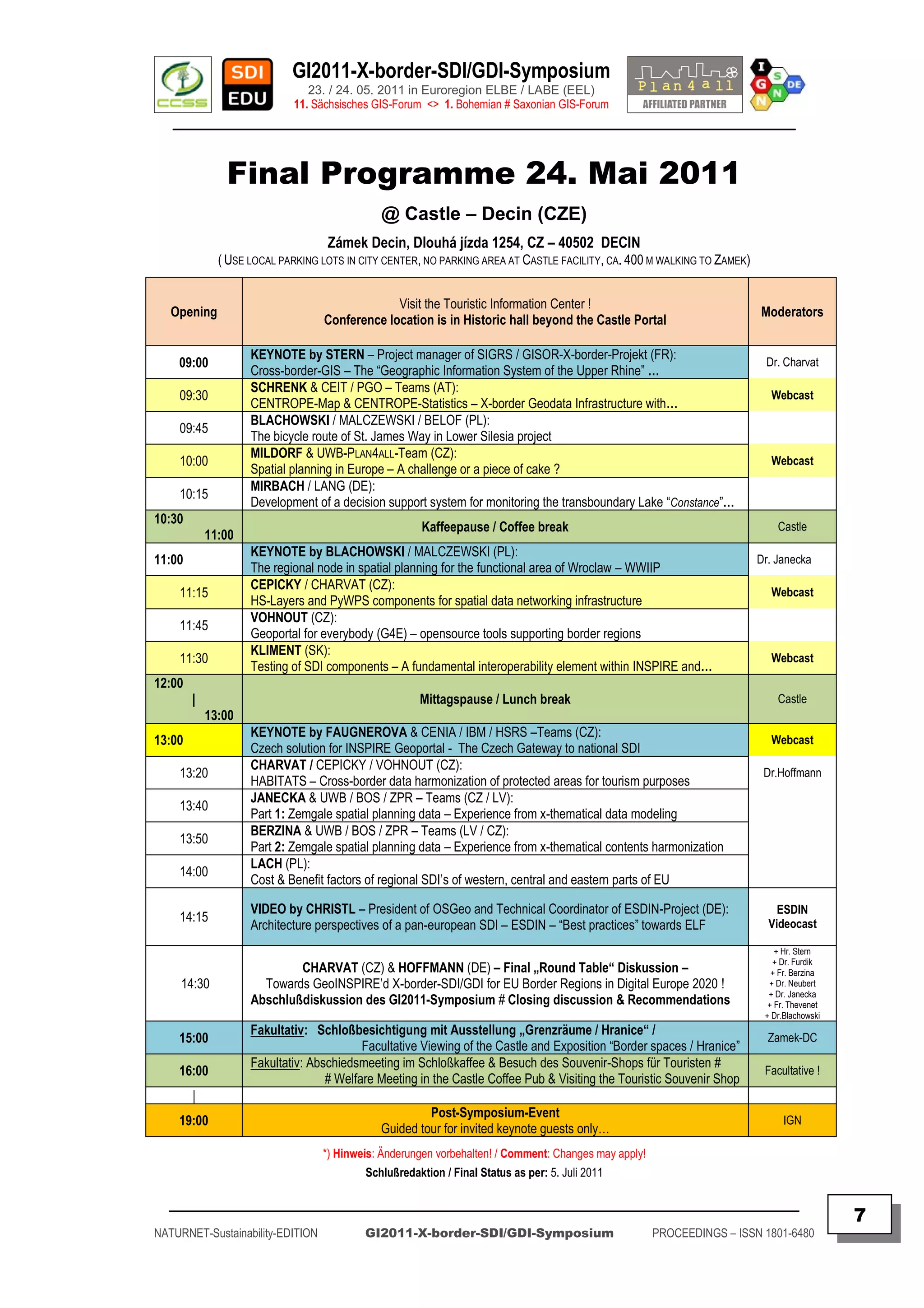
24.05. 08:00 Registration at Conference Location of Decin Castle DECIN (CZ)
09:00 OPENING & X-SDI/GDI Session 5 (X-GDI/SDI-Integration ) [ DECIN-City ] (CZ)
10:30 Kaffeepause / Coffee-Break [ DECIN-Zamek ] (CZ)
X-SDI/GDI-Session 6 (X-Mapping/ X-Statistics/ X-Planning)
11:00 [ DECIN-Castle ] (EN)
Cross-border Applications
12:00 Mittagspause / Lunch-Break [ DECIN-Burg ] (DE)
X-SDI/GDI-Session 7 (Education, Innovation & Research)
13:00 [ Travel-Tips ] (EN)
GEOSS and GMES Applications
14:30 Kaffeepause / Coffee-Break [ DECIN-WebCAM ] (CZ)
X-SDI/GDI-Session 8 (X-PSI/-INSPIRE-Challenges in EBR)
15:00 [ DECIN-Video ] (EN)
Brainstorming & Conclusions for EuropeanBorderRegions
16:00 Closing of the GI2011-X-border-Symposium [ DECIN-Cruise-MAP ] (EN)
24.05. 17:00 Post-Symposium Social Guided Tour for Invited Guests DECIN (CZ)
Important Deadlines for active Authors:
30.03.2011 Registration FORM for passive participants will be available for registration and social events !
31.03.2011 Information for Keynoters + Authors & preliminary GI2011-X-border-Symposium Agenda DRAFT
25.04.2011 Summary delivery by Authors ( Summary template.doc to be used/sent: [ Mailto:GI2011@CCSS.de ] )
15.05.2011 Präsentation delivery (PPT) by Authors ( to be sent: [ Mailto:GI2011@IGN-SN.de ] )
23.05.2011 Poster delivery by Authors at Registration DESK for Exhibition 24.05. at DECIN Conference Location
*) Präsentationen erfolgen sich ergänzend in Deutsch und Englisch – Example: Abstract (RU), Summary (EN), PPT (DE), Presentation (EN)
**) Sprache: Es erfolgt keine simultane Übersetzung der Vorträge / Language: There will be no simultanous translation of presentations
***) Keynotes: ca. 20-30 min (incl. 5 min Q & A) / Presentations: ca. 10-15 min (incl. 5 min Q & A) as fixed in the Final Programme
****) Internetzugang: vorhanden / WiFi Connectivity as well multimedia tools and devices will be provided
_________________________________________________________________________________________
5
NATURNET-Sustainability-EDITION GI2011-X-border-SDI/GDI-Symposium PROCEEDINGS – ISSN 1801-6480](https://image.slidesharecdn.com/gi2011proceedingsv5final-110705072117-phpapp02/75/GI2011-proceedings-v5-final-5-2048.jpg)
![GI2011-X-border-SDI/GDI-Symposium
23. / 24. 05. 2011 in Euroregion ELBE / LABE (EEL)
11. Sächsisches GIS-Forum <> 1. Bohemian # Saxonian GIS-Forum
________________________________________________________________________________________
Final Programme 23. Mai 2011
@ NPZ – Bad Schandau (SAX)
LOCATION ADDRESS: National-Park-Zentrum, Dresdner Str. 2b, D – 01814 BAD SCHANDAU
( Use car parking lots at nearby Elbe river, 100 m from NPZ )
09:00
Anmeldung im Nationalparkzentrum Bad Schandau (SAX) / Opening
|
10:00 / Registration in the National Park Center of Bad Schandau (SAX) Moderators
CHARVAT (CZ) / HOFFMANN (DE): Opening & Welcome Addresses by CCSS, IGN and by
10:00 Dr. Michael
Local / Regional Authorities of Bad Schandau / Euroregion “Elbe#Labe”
NATIONALPARK-ZENTRUM-Multivision:
10:15
Film: Natur protection in Cross-border “Bohemia # Saxonia Switzerland“ (15 min)
KEYNOTE by RAMIREZ / AEBR – Generalsekretär (ES):
10:30
Grenzüberschreitende Regionen in Europa – Eine Bestandsaufnahme
KNIPPSCHILD (DE):
11:00 Dr. Hoffmann
Nothing – But a waste of time and money ? – Specifics of cross-border cooperation in the …
KEYNOTE by THEVENET / EUROINSTITUT – Stellv. Direktorin (FR):
11:20
Characteristics and Challenges for successful cross-border cooperation
BENDEL (DE):
11:50
Grenzüberschreitende Verflechtungsräume und Analyse von Fachdaten zur Beschreibung …
12:00
| Mittagspause / Lunch break
13:00
Einführung POSTER-Kurzporträts / Introduction to POSTER-Descriptions by MAYER – PROGIS (AT)
13:00 + BLACHOWSKI & WBU-Team + FURDIK & STUBA-Teams (SK) + GEDRANGE & IOER-Team (DE)
Posters
KEYNOTE by MAYER (AT):
13:15 Dr. Charvat
GIS-Software across AGRI applications and integration of BING-Maps
RAITIS / DZERVE / ALBERTS (LV): Webcast
13:45
The “BIZBIZ”-Tool as an online platform for cross-border education in the SDI-EDU project
JANECKA (CZ) & SDI-EDU-Team:
14:00
LEONARDO „SDI-EDU-Project“ as a framework for vocational education in EU BorderRegions
KLIMENT / OGGIONI (IT):
14:15 Webcast
Bringing Eco-Biological Metadata to the INSPIRE metainformation world
14:30
Kaffeepause / Coffee break
15:00
KEYNOTE by CHARVAT (CZ): Dipl.Ing.
15:00 MAYER
The pyramide or spider network – towards social geospatial space in European Border Regions
KAFKA / CHARVAT (CZ):
15:25 Webcast
Sharing metadata across Europe – Experiences from ONEgeology and PLAN4ALL research …
CHARVAT / VOHNOUT (CZ):
15:35
ENVIROGRIDS towards “Black Sea” catchment regions – cross-border SDI for water and …
ALBERTS & ICMS-Team (LV):
15:50 Webcast
Economic activity in cross-border marine habitats
ROEHNERT / GEDRANGE / NEUBERT (DE):
16:00
Cross-border data harmonization in practice – examplified by German ATKIS & Czech ZABAGED
HOFFMANN (DE):
16:20
Challenges and opportunities for EBR – Analysis of X-border-Geoportals and GeoINSPIRE‟d …
FINAL Day 1: “Round Table” Dr. Hoffmann
16:40 & Dr. Charvat
Discussion & Summarizing
RE-Locating from Bad Schandau (SAX) across the border
17:00
via Hrensko (CZE) to DECIN (CZE)
17:30 Accomodation and Relax time etc. at Hotels
Accomodation
19:30 Location of Hotel “Ceska Koruna” [ Masarykovo náměstí 60, CZ - 40501 Děčín ]
19:30 Abendveranstaltung im „Lounge Room“ des Restaurants „Hotel zur Post“
| Location @ [ Masarykovo náměstí 9, CZ - 40501 Děčín | Lounge Room ] Get_together
| Social Get together at “Lounge room” of Restaurant “Hotel Posta” in Decin
22:00 End of Day 1
*) Hinweis: Änderungen vorbehalten! / Comment: Changes may apply!
_________________________________________________________________________________________
6
NATURNET-Sustainability-EDITION GI2011-X-border-SDI/GDI-Symposium PROCEEDINGS – ISSN 1801-6480](https://image.slidesharecdn.com/gi2011proceedingsv5final-110705072117-phpapp02/75/GI2011-proceedings-v5-final-6-2048.jpg)
![GI2011-X-border-SDI/GDI-Symposium
23. / 24. 05. 2011 in Euroregion ELBE / LABE (EEL)
11. Sächsisches GIS-Forum <> 1. Bohemian # Saxonian GIS-Forum
________________________________________________________________________________________
GI2011 – CROSS-BORDER – SDI/GDI – SYMPOSIUM FOR
EUROPEAN BORDER REGIONS – 23./24. MAY 2011
Nationalparkhaus Bad Schandau © NationalparkZentrum # Decin - Děčínský (Castle) zámek nad Labem © Wikipedia.cz
Castle Rose Garden / Zamek Rozárium Děčín – Copyright by Wikipedia (cc) [ http://creativecommons.org/licenses/by-sa/2.0/deed.cs ]
Castle / Zamek – Decin: Copyright by (cc) [ http://cs.wikipedia.org/wiki/Soubor:Decin001.jpg ]
_________________________________________________________________________________________
8
NATURNET-Sustainability-EDITION GI2011-X-border-SDI/GDI-Symposium PROCEEDINGS – ISSN 1801-6480](https://image.slidesharecdn.com/gi2011proceedingsv5final-110705072117-phpapp02/75/GI2011-proceedings-v5-final-8-2048.jpg)
![GI2011-X-border-SDI/GDI-Symposium
23. / 24. 05. 2011 in Euroregion ELBE / LABE (EEL)
11. Sächsisches GIS-Forum <> 1. Bohemian # Saxonian GIS-Forum
________________________________________________________________________________________
Finally, the Organizers, the non-profit Associations CCSS & IGN, as well
as UniWB would like to say you:
WELCOME to our inter-regional, trans-national & cross-border participants, guests and
authors celebrating the traditional Anniversary of “11. Sächsisches GIS-Forum” as a
1
cross-border forum event, the “1. Bohemia # Saxonia GIS-Forum” by contributing,
1
discussing and exchanging cross-border-awareness, information and experience;
THANK YOU to the keynote experts, session speakers, poster contributors and tele-
presenters finally from 10 Countries:
AT + CZ + DE ( BW +SN ) + EU ( AEBR +ESDIN +EUROINSTITUT ) + FR + IT + LV + PL + SK
ready to share with local, regional and cross-border communities their vision, information,
knowledge and expertise, the way forward for better citizens awareness, metadata and cross-
border data interoperability and sustainability of x-border & inter-regional communication,
coordination and collaboration.
ACKOWLEDGEMENT is given to several organizations and companies providing
conference materials like flyers, posters, fact sheets, demos, reports, and supporting us to
organize this GI2011-Symposium, important especially for our colleagues from CEE
countries, especially the following supporters have to be named (see p. ??? for details):
AEBR, Alsac-Region-CG68, CCSS, ESDIN, ESRI-Press, EUROINSTITUTE,
FREE STATE OF SAXONY, GeoSN, IGN-SN, K21 MEDIA AG, KOGIS/SWISS TOPO,
KULK-CZ, MIR/GLPA-BERLIN/BRANDENBURG, MOT-FR, NATIONALPARKZENTRUM,
PROGIS-AT, SENATSVERWALTUNG-Berlin, SIG Media GmbH&Co.KG/Köln,
SIGRS/GISOR-FR, STUBA-SK, UniWB-CZ, WBU-PL, ZAMEK-DECIN-CZ.
Dresden / Praha 23. Mai 2011
Authors
Doz. Dr. Frank HOFFMANN, CSc & Dr. Karel CHARVAT
References
ARCHIV: GI2010-Symposium - 10. Sächsisches GIS-Forum, Dresden 2010
[ http://epsiplatform.eu/psi_library/reports/gi2010_dresden_symposium_may_2010 ]
ARCHIV: GI2009-Symposium - 9. Sächsisches GIS-Forum, Dresden 2009
[ http://www.epsiplatform.eu/reports/gi2009_dresden_symposium_may_2009 ]
ARCHIV: GI2008-Symposium - 8. Sächsisches GIS-Forum, Dresden 2008
[ http://www.epsiplus.net/reports/gi2008_dresden_symposium_may_2008 ]
EU-FP6/7-Projects-NATURNET
[ http://www.NATURNET.org ]
GEOSPATIAL SAXONY – WEBLOG – GDI-SN
[ http://GDI-SN.blogspot.com ]
CZECH CENTER OF SCIENCE & SOCIETY
[ http://www.CCSS.cz ]
Contact
IGN - INNOVATION. Grenzüberschreitendes Netzwerk e.V.
c/o IGN-Vorstand, Martin-Andersen-Nexö-Str. 4, D-01217 DRESDEN / Saxony / Germany
Email [ Mailto:Vorstand@IGN-SN.de ] + [ Mailto:info@GDI-SN.de ]
_________________________________________________________________________________________
17
NATURNET-Sustainability-EDITION GI2011-X-border-SDI/GDI-Symposium PROCEEDINGS – ISSN 1801-6480](https://image.slidesharecdn.com/gi2011proceedingsv5final-110705072117-phpapp02/75/GI2011-proceedings-v5-final-17-2048.jpg)
![GI2011-X-border-SDI/GDI-Symposium
23. / 24. 05. 2011 in Euroregion ELBE / LABE (EEL)
11. Sächsisches GIS-Forum <> 1. Bohemian # Saxonian GIS-Forum
________________________________________________________________________________________
distance in which individuals are clustered: Dot sizes: = 1,000+ = 100 - 999 = 10 - 99 = 1 - 9 visits
th
As per 14 May 2011 @ 07:58 GMT – Total access since 28 Dec 2007: 7.463.
th hrs
3.800 visits shown above as from 30 Dec 2009 to 18 Apr 2011 - Previous 24 : 15
CLUSTERMAPS © 2011 Access Statistics for IGN‟s Weblog URL [ http://GDI-SN.blogspot.com ]
IGN e.V. - INNOVATION.Grenzüberschreitendes Netzwerk (X-border Network) - is a non-profit
Association (gemeinnütziger Verein) for Education, Development and Knowledge Transfer - has been
founded first in 2002 as "GDI-Sachsen" (i.G.) - the final outcome of the "OpenGIS Strategy Seminar"
series in GI2000 & GI2002 at "Bildungswerk Ost-West" (BOW), but was re-founded later on as the
follow-up "IGN" (e.V.) at September 2nd, 2003, by Czechia and Saxonia experts of Cartomatics,
Cyberlaw, Cybernetics, Geomatics, Economics, Mediamatics, Pedagogics, Regional Development and
Spatial Sciences.
Its main goals: supporting GEO - ENVIRO - SPATIO - oriented Awareness, Business and Openness in
Training, Education and Research on GeoINSPIRE‟d Interoperability, Sustainability, and Usability of
spatial Data, Services and Applications for X-border-Infrastructures of Spatial Information (X-INSPIRE)
in EUROPE of REGIONS.
IGN has been registered by Dresden City Court officially as a Non-profit Association, October 16th, 2003
[ http://www.IGN-SN.de/Registration.pdf ] - [ Mailto:Vorstand@IGN-SN.de ]
[ Copyright © 2011 by IGN e.V. - All rights reserved. ]
The CCSS – Czech Center for Science and Society – is an Association of high tech SMEs, the public
administration and research organizations. It is an independent, non-profit and non-governmental
organisation. It is a type of virtual centre of excellence with the focus on the implementation of new
communication and navigation technologies which have potential for sustainable development.
The CCSS co-operates with a wide range of institutions and individuals, home and foreign ones. It is
focused on research & development activities in the field of international research projects and
utilization of modern technologies. CCSS supports co-operation networks of the small and medium
business within the framework of regional economies and helds intensive contacts, particularly in Europe,
Asia, Africa and South America.
CCSS is focused on transfer, analyses and development of the most advanced GI & ICT technologies
which are contributing to the growth of productivity not only in industrial enterprises but in the branch of
small and medium business as well. CCSS is active in the agriculture, industry, trade and services,
predominantly in agricultural regions.
The priority of activities of CCSS is Environment protection and Crisis management. In this field CCSS
is active in European FP7 research and “best practice” excellence & social networks.
[ Copyright © 2011 by CCSS, Praha - All rights reserved. ]
_________________________________________________________________________________________
18
NATURNET-Sustainability-EDITION GI2011-X-border-SDI/GDI-Symposium PROCEEDINGS – ISSN 1801-6480](https://image.slidesharecdn.com/gi2011proceedingsv5final-110705072117-phpapp02/75/GI2011-proceedings-v5-final-18-2048.jpg)
![GI2011-X-border-SDI/GDI-Symposium
23. / 24. 05. 2011 in Euroregion ELBE / LABE (EEL)
11. Sächsisches GIS-Forum <> 1. Bohemian # Saxonian GIS-Forum
________________________________________________________________________________________
GRENZÜBERSCHREITENDE REGIONEN IN
EUROPA – EINE BESTANDSAUFNAHME
Martín Guillermo-Ramírez
ARBEITSGEMEINSCHAFT EUROPÄISCHER GRENZREGIONEN - AGEG
ABSTRACT – OPENING KEYNOTE
Keywords: AEBR, AGEG, ARFE, Border regions, Cooperation, Cross-border, Europa,
Euroregionen, EVTZ, EGTC, GECT, Europe, Grenzregionen, Integration
Contents:
Grenzübergreifende Zusammenarbeit ist inzwischen eine der Hauptaufgaben
der Europäischen Union. In der Vergangenheit wurden viele Einrichtungen geschaffen,
mit denen die Grenzregionen vorangebracht werden sollen:
Euroregionen, Arbeitsgemeinschaften, Netzwerke oder kürzlich die EVTZ„s
(Europäischer Verbund für territoriale Zusammenarbeit). All diese haben die
grenzübergreifenden Regionen in ein unersetzliches Werkzeug verwandelt, um Europa
den Menschen näher zu bringen.
Grenzregionen sind häufig dünn besiedelt, leiden an mangelhafter Infrastruktur
sowie an der Abwanderung ihrer gut ausgebildeten Kräfte. Manche sind allerdings auch
urbaner Natur mit Millionen Einwohnern und auf diese Weise Beispiele für europäische
Metropolen.
In diesen ganz unterschiedlichen Gebieten, in denen Europa jeden Tag gelebt
wird, gibt es beispielsweise Zentren alter Traditionen, ebenso aber auch
Zusammenschlüsse, in denen Stadt-Land-Partnerschaften entstehen.
An unseren Binnengrenzen (aber auch an den Außengrenzen und darüber
hinaus) ist nahezu alles möglich: dort, auf den ehemaligen Schlachtfeldern, zeigt sich
heute Europa von seiner besten Seite. Auf den Narben der Vergangenheit entstanden die
Wirkungsstätten der europäischen Integration.
Author
Martín Guillermo-Ramírez
Secretary General
Association of European Border Regions (AEBR)
References
[ http://www.AEBR.eu ]
[ Grenzüberschreitende Regionen in Europa ]
Contact
Association of European Border Regions (AEBR)
Enscheder Str. 362, D-48599 Gronau
Tel.: +49 (0) 2562 - 702 19
Fax: +49 (0) 2562 - 702 59
E-Mail: [ m.guillermo@aebr.eu ] | Web: [ www.aebr.eu ]
_________________________________________________________________________________________
19
NATURNET-Sustainability-EDITION GI2011-X-border-SDI/GDI-Symposium PROCEEDINGS – ISSN 1801-6480](https://image.slidesharecdn.com/gi2011proceedingsv5final-110705072117-phpapp02/75/GI2011-proceedings-v5-final-19-2048.jpg)
![GI2011-X-border-SDI/GDI-Symposium
23. / 24. 05. 2011 in Euroregion ELBE / LABE (EEL)
11. Sächsisches GIS-Forum <> 1. Bohemian # Saxonian GIS-Forum
________________________________________________________________________________________
ECONOMIC ACTIVITY IN CROSS-BORDER
MARINE HABITATS
M. ALBERTS, A. IKAUNIECE, P. BRUNS, J. KALNINS, J. MARTINSONS
IMCS, Riga - LV
ABSTRACT
Keywords: biotope, habitats, INSPIRE, meta-data, modelling SDI, species
Abstract:
Latvian marine coastal habitats are currently represented by various datasets owned by
Latvian Institute of Aquatic Ecology (LIAE). As the coastal region encompasses also protected areas
(Natura 2000) with limited allowed actions the knowledge on location of habitats and their value is
essential for all types of economical activities.
The cross-border nature of any marine data on habitat situation therefore is relevant also for
the other countries sharing the Baltic Sea area. The provision of information about possible economical
activities in marine areas is one of the pilot cases in INSPIRED HABITATS project. Its infrastructure
and platform implementation is planned as compliant to INSPIRE requirement. To be more closer to
citizens, stakeholders, science enthusiasts & businessmens the INSPIRED HABITATS project is trying to
use also social networks to attract all these user groups and experts to validate the pro‟s and con‟s for
INSPIRE data models and its usage to solve real world problems.
This is the first INSPIRE compliant habitats and species distribution meta-data and data
model implementation trial in Latvia. Continuous data model evolution is being implemented due to
changing user requirements and development of INSPIRE Directive data model specifications.
The Data model implementation is developed by Latvian Institute of Aquatic Ecology (LIAE)
in collaboration with Institute of Mathematics and Computer Science of the University of Latvia
(IMCS). The Database consists of monitoring and observation data about habitats, species and physical
characteristics collected during the last 35 years. Bottom type, physico-chemical features – temperature
and salinity regimes, content of oxygen and nutrients, density of benthic animals have been sampled and
measured for a few decades in the framework of national marine monitoring.
SDI software implementation is based on open source components and follows ideas of
European project PLAN4ALL that allows adaptation of solution easily in future for other countries across
the Baltic Sea area.
Authors
Dr. math. Māris ALBERTS, Dr. biol. Anda IKAUNIECE, Bc. Ing. Peteris BRUNS,
Dr.comp.sc. Janis KALNINS, Dr.comp.sc.Janis MARTINSONS
References
INSPIRED HABITATS. 2010-2011. Internet [http://www.inspiredhabitats.eu/]
Janecka K., Berzins R., Charvat K., Dzerve A.: The “GeoPortal4everybody & BizBiz” tools as a
modern technological framework for vocational e-learning. In: Proceedings of ELDE Conference, Sofia:
2011, p. 215
Contact
IMCS – Institute of Mathematics and Computer Science – University of Latvia (LV)
Department of Real time systems
Raina bulvaris 29, Riga, LV-1459 Latvia
Tel: +371 67226997 Fax: +371 67820153
Email: [ alberts@latnet.lv ]
_________________________________________________________________________________________
20
NATURNET-Sustainability-EDITION GI2011-X-border-SDI/GDI-Symposium PROCEEDINGS – ISSN 1801-6480](https://image.slidesharecdn.com/gi2011proceedingsv5final-110705072117-phpapp02/75/GI2011-proceedings-v5-final-20-2048.jpg)
![GI2011-X-border-SDI/GDI-Symposium
23. / 24. 05. 2011 in Euroregion ELBE / LABE (EEL)
11. Sächsisches GIS-Forum <> 1. Bohemian # Saxonian GIS-Forum
________________________________________________________________________________________
CROSS-BORDER INTERWEAVEMENT
AN ANALYSIS OF DATA AVAILABILITY DESCRIBING CROSS-BORDER
INTERWEAVING OF SAXONY’S BORDER REGIONS
Frank BENDEL
Dresden University of Technology, Institute of Geography (DE)
ABSTRACT
Keywords: data availability, cross-border interweavement, regionalization
Contents:
This presentation contains the following thesis of diploma research:
Interconnected cross-border regions, a new shape for cross-border areas
The regionalization and their possibilities for the delimitation of regions
The procedure of data research for cross-border development
Data availability in Saxony describing cross-border interweavement
First steps to compare the data availability between Saxony and the so-called
MORO-Regions
Measures for a better data availability
Author
Dipl.-Geogr. Frank Bendel
Reference
Bendel, F. (2010). Grenzüberschreitende Verflechtungsräume – Eine Analyse
grenzüberschreitender Verflechtungen an den Außengrenzen Sachsens,
Diplomarbeit: TU Dresden.
Contact
Frank Bendel
phone: 0049 351 482 9364
Email: [ bendel.frank@yahoo.de ]
_________________________________________________________________________________________
21
NATURNET-Sustainability-EDITION GI2011-X-border-SDI/GDI-Symposium PROCEEDINGS – ISSN 1801-6480](https://image.slidesharecdn.com/gi2011proceedingsv5final-110705072117-phpapp02/75/GI2011-proceedings-v5-final-21-2048.jpg)
![GI2011-X-border-SDI/GDI-Symposium
23. / 24. 05. 2011 in Euroregion ELBE / LABE (EEL)
11. Sächsisches GIS-Forum <> 1. Bohemian # Saxonian GIS-Forum
________________________________________________________________________________________
ZEMGALE SPATIAL PLANNING DATA - EXPERIENCE FROM
CROSS-THEMATICAL CONTENTS HARMONIZATION
Inga BERZINA – Zemgale Planning region (LV)
Peteris BRUNS – Baltic Open Solution Centre (LV)
Otakar CERBA, Radek FIALA, Jan JEZEK, Karel JANECKA, Karel
JEDLICKA, Tomas MILDORF – University of West Bohemia in Pilsen (CZ)
ABSTRACT
Keywords: spatial planning, data, models, harmonization, region, land cover, Plan4all, SDI-EDU
Contents:
Spatial planning could be defined as a set of policies (including planning and
controlling activities) on the distribution of resources and facilities across urbanized areas. One
of the conditions of successful spatial planning activities and decisions is an accessibility of
high-quality spatial data sets. Experts and institutes participating on spatial planning and similar
activities (like urban or regional planning) have two options:
To buy or to collect spatial data – such data has to be managed and updated by using own resources or
an outsourcing.
To re-use existing shared spatial data sets.
The main problem of the second solution is the incompatibility of spatial data
provided by different sources. The incompatibility (or heterogeneity) consists of different
scales, granularity, terminology, data models, data formats, portrayal rules etc. These categories
represent the aspects of spatial data harmonization – the process of elimination of
heterogeneities of two or more spatial data sets.
As an illustration of pros and cons of spatial data harmonization there were selected
two spatial data sets – “land cover model of the Plan4all project” using the CORINE land cover
nomenclature (as an example of widely dispersed and used European land cover and land use
data) and spatial data provided and administered by Zemgale region (Latvia). Still in Latvia is
used non standardized data model for planning data but model definition is in process - each
spatial plan is with unique data structure, symbology and structural detail.
Zemgale planning region (one of the 5 regions of Latvia) already started to harmonize
in region existing planning data to one common data model, currently is static and generalized
to be usable in rural and urban areas.
The harmonization of Zemgale spatial data to the structure developed in the Plan4all
project according to INSPIRE principles will be explained using four different GIT tools:
ESRI-ArcGIS, HALE (Humboldt Alignment Editor), Open Studio (including Spatial
Data Integrator), and PostgreSQL database solution (using SQL queries).
Authors
Ing. et Mgr. Otakar Cerba; Ing. Radek Fiala; Ing. Jan Jezek, Ph.D.; Ing. Karel Janecka,
Ph.D.; Ing. Karel Jedlicka, Ph.D.; Ing. Tomas Mildorf;
Peteris Bruns & Mgr.oec. Phd Inga Berzina
Reference
eContentPlus project “Plan4all”
[ http://www.plan4all.eu/simplecms/?menuID=32&action=article&presenter=Article ]
Contact
Zemgale Planning region
Katolu iela 2b, Jelgava, Latvia LV3001
phone: +37-1-63027549 & fax : +37-1- 63084949
[ Email: Inga.Berzina@zpr.gov.lv ]
_________________________________________________________________________________________
23
NATURNET-Sustainability-EDITION GI2011-X-border-SDI/GDI-Symposium PROCEEDINGS – ISSN 1801-6480](https://image.slidesharecdn.com/gi2011proceedingsv5final-110705072117-phpapp02/75/GI2011-proceedings-v5-final-23-2048.jpg)
![GI2011-X-border-SDI/GDI-Symposium
23. / 24. 05. 2011 in Euroregion ELBE / LABE (EEL)
11. Sächsisches GIS-Forum <> 1. Bohemian # Saxonian GIS-Forum
________________________________________________________________________________________
EXPERIENCE FROM CROSS-THEMATICAL CONTENTS
HARMONIZATION
( INGA BERZINA )
Zemgale is one of the five regions, situated in the Latvian central area to the south of Riga. The
region is located along the Latvian - Lithuanian border and adjacent to the Latgale, Vidzeme, Riga and
Kurzeme planning regions. Zemgale covers 16.6% of the total territory of Latvia with 12.5% of the total
population.
Zemgale Planning Region (ZPR) is a public body / legal entity which role is to undertake
planning of the development of the region and to ensure a link between the region‟s development
priorities and industry development plans at the national level as well as promote cooperation and
coordination among the municipalities and other public bodies in the region. ZPR consists of 22 local
governments, the decision making body is Development Council and an executive body - Planning
Region Administration. According to the Development Planning law the planning regions’
competence is:
to provide regional and local planning documents of mutual consistency and coherence with
hierarchically higher development planning documents and planning documents regulating
system of laws and regulations –
to administer and supervise the planning of regional development planning documents and the
elaboration and their implementation.
The initial work on Zemgale geo-portal started with the Norway Grant Project “Capacity
Building of Zemgale Region for Strengthening the economical Activities and Cooperation with
Norwegian institutions”, whose aim was to enhance the balanced and sustainable socio-economical
development of Zemgale region while preserving its specific territorial characteristics. Within in the
project the innovative approach for previously not formulated issues – processes, classifications, data –
for the first time in Latvia there have been worked out methodological guidelines for the comprehensive
territorial development planning document format on regional and local governments‟ planning levels:
defining the minimal (compulsory) and advisable requirements for the development planning
documents
monitoring their contents, drafting process, approval and implementation.
Proposals for development of the database of territorial plans and the joint land use type
(zoning) classification have been worked out. Based on ESRI technologies the Zemgale Geoportal
[http://gisdb.zpr.gov.lv/gis] has been developed with a unified central database for industrial territories
enabling and providing decentralized data input at local level.
Since 2009 the Zemgale Planning Region is one of the partners in the eContentPlus project
network PLAN4ALL, which is focused on the harmonization of spatial planning data based on the
existing “best practices” in other EU regions and municipalities and results of current research projects.
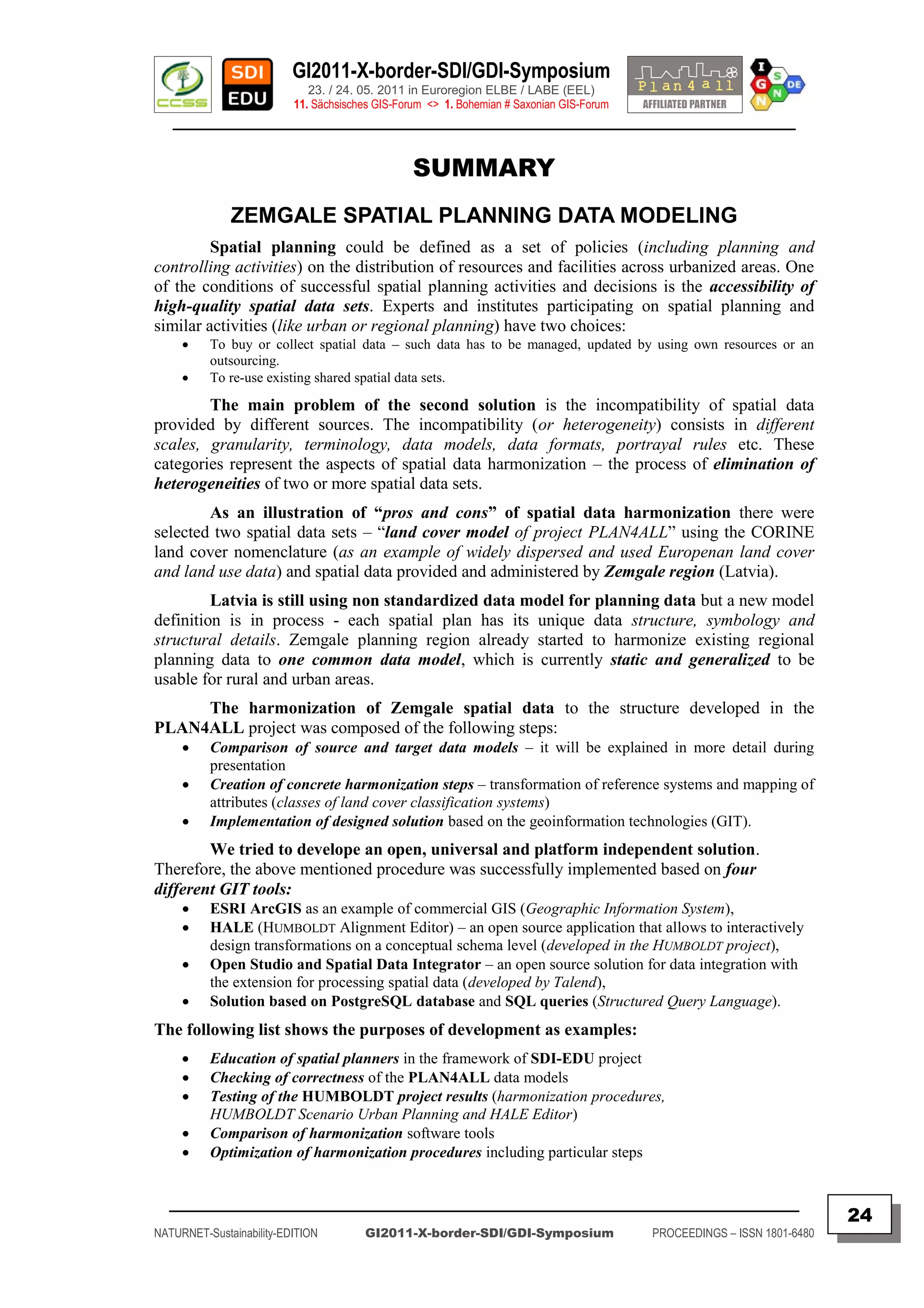
The Zemgale Planning Region, in order to fulfil the project aims, has introduced the Geoportal
system solution for spatial data infrastructures developed by the Czech Centre for Science and Society
(CCSS). The ZPR Geoportal is enabling interoperability of the two CCSS & ZPR servers.
The harmonization of Zemgale spatial data into the structure developed in the PLAN4ALL
project for Land Cover and Land Use has been composed of the following steps:
Comparison of source and target data models
Creation of concrete harmonization steps:
transformation of reference systems and
mapping of attributes (classes of land cover classification systems)
Transformation of attributes and values:
comparison of enumerations of the source and target data (for Land Use)
Implementation of the designed solution to the geoinformation technologies (GIT).
The project activities are based on data and metadata descriptions as well as on
implementation of Web Map Service (WMS) and Web Feature Service (WFS):
_________________________________________________________________________________________
25
NATURNET-Sustainability-EDITION GI2011-X-border-SDI/GDI-Symposium PROCEEDINGS – ISSN 1801-6480](https://image.slidesharecdn.com/gi2011proceedingsv5final-110705072117-phpapp02/75/GI2011-proceedings-v5-final-25-2048.jpg)
![GI2011-X-border-SDI/GDI-Symposium
23. / 24. 05. 2011 in Euroregion ELBE / LABE (EEL)
11. Sächsisches GIS-Forum <> 1. Bohemian # Saxonian GIS-Forum
________________________________________________________________________________________
THE “BIZBIZ” TOOL AS AN ONLINE PLATFORM
FOR CROSS-BORDER EDUCATION IN SDI-EDU
PROJECT
Raitis BERZINS & ICMS-Team
University of Latvia – IMCS – Riga (LV)
ABSTRACT
Keywords: bizbiz, e-learning, inspire, meta-data, modelling, sdi-edu, video lectures
Contents:
The “BizBiz” tool is an opensource web browser based e-conference, collaboration and
learning tool which supports slide shows, web page demonstration, synchronous pre-recorded video
display, chat and lecturers live narration using web camera provided video and audio.
It is part of the SDI-EDU platform for vocational e-learning which is designed and
implemented as a virtual database based on social network principles of the GeoPortal4everybody and
principle of web services using Unified Resource Management (URM). The SDI-EDU project aims to
knowledge transfer of former experiences gained from different EU research projects like HUMBOLDT and
NATURNET+REDIME (NNR) dealing with education on SDI for spatial planning towards sustainable urban
& regional planners in European ( border ) Regions and Municipalities.
In the second year of the project various improvements to “BizBiz” tool has been made
ranging from multilingual content support to integration with social networks and mapping services.
Modelling of the BizBiz” system in different usage scenarios and load conditions has been carried out
and predictions of its behavior has been made.
The “BizBiz” learning database now consists of ~50 presentations about SDI related subjects
in 6 european languages to be usable with “BizBiz” tool support.
The “BizBiz” tool has been developed in the Institute of Mathematics and Computer Science
(IMCS) and is used in EU projects like NaturNetplus and SDI-EDU to support learning processes about
the use of Geographic Information Systems and implementation of the INSPIRE-Directive.
Authors
Mgr. comp. Raitis Bērziņš & MSc. Andris Dzerve & Dr. math. Māris Alberts
References
IMCS: “BizBiz” online lecturing tool. Riga: 2010.
Internet [ http://sdi-edu.zcu.cz/wiki/Main_Page ]
Raitis Bērziņš: GIS education using online video lectures – The OpenSource “BizBiz”-Project.
In: Proceedings of GI2010-Symposium, Dresden: 2010, p. 26
[ http://www.epsiplatform.eu/content/download/55172/760157/version/1/file/GI2010-Symposium-BERZINS+%28BizBiz%29.pdf ]
Janecka K., Berzins R., Charvat K., Dzerve A.: The “GeoPortal4everybody & BizBiz” tools as a
modern technological framework for vocational e-learning. In: Proceedings of ELDE Conference, Sofia:
2011, p. 215
Contact
Institute of Mathematics and Computer Science, University of Latvia
Department of Realtime Systems
Raina bulvaris 29, Riga, LV-1459 Latvia
Tel: +371 67226997 & Fax: +371 67820153
Email: [ alberts(at)latnet.lv ]
_________________________________________________________________________________________
27
NATURNET-Sustainability-EDITION GI2011-X-border-SDI/GDI-Symposium PROCEEDINGS – ISSN 1801-6480](https://image.slidesharecdn.com/gi2011proceedingsv5final-110705072117-phpapp02/75/GI2011-proceedings-v5-final-27-2048.jpg)
![GI2011-X-border-SDI/GDI-Symposium
23. / 24. 05. 2011 in Euroregion ELBE / LABE (EEL)
11. Sächsisches GIS-Forum <> 1. Bohemian # Saxonian GIS-Forum
________________________________________________________________________________________
THE BICYCLE ROUTE OF “ST. JAMES” WAY IN
LOWER SILESIA PROJECT
Jan BLACHOWSKI & Przemysław MALCZEWSKI
Dolnoslaskie Voivodeship Marshal's Office, Spatial Planning Regional Bureau Wroclaw (PL)
ABSTRACT
Keywords: St. Jacob’s Way, Via Regia Plus, bicycle trails, GPS navigation
Contents:
The Way of St. James (Camino de Santiago) is an European network of
pilgrimage routes leading to the shrine of Sanitago de Compostela in NW Spain, which
is the resting place of St. James the Apostle. A beacon for all travellers is a white or
yellow scallop shell a symbol of St. James.
The Lower Silesian part of the network, in Poland, consists of four trails: the
Via Regia extending from Brzeg in the East, through Wroclaw, Legnica and Luban to
Zgorzelec in the West, the Lower Silesian Way extending NE from Luban on the Via
Regia towards Gdansk, Via Cervimontana running from Jelenia Gora in the Sudety
Mts. and joining Via Regia in Luban and Sleza Way extending from Mt. Sleza south of
Wroclaw and joining Via Regia in Sroda Slaska. Within the frames of the project Via
Regia Plus carried out under the Programme for Central Europe of the European
Territorial Cooperation (ETC) work has been done to analyse and propose the course of
St James Way for bicycle use.
In the results of field work, which included cycling on over 550km of trails,
four bicycle routes accessible for a casual cyclist have been proposed.
Results of this work have been presented during final conference in Wroclaw
in December 2010. Information on the project can be found at the internet link cited in
references.
Authors
Dr. Magdalena BELOF, Dr. Jan BLACHOWSKI, Przemysław MALCZEWSKI
Reference
Outline of a cycle route “The Way of St. James, in Lower Silesia”
[ http://www.wbu.wroc.pl/3.3.1./?lang=en ]
Contact
Regional Bureau of Spatial Planning, Dolnoslaskie Voivodeship Marshal's Office
ul. Swidnicka 12-16, 50-068 Wroclaw, Poland,
phone: 0048 71 343 79 46
fax : 0048 71 344 52 45
Email: [jblachowski@poczta.wbu.wroc.pl ] + [pmalczewski@poczta.wbu.wroc.pl ]
_________________________________________________________________________________________
28
NATURNET-Sustainability-EDITION GI2011-X-border-SDI/GDI-Symposium PROCEEDINGS – ISSN 1801-6480](https://image.slidesharecdn.com/gi2011proceedingsv5final-110705072117-phpapp02/75/GI2011-proceedings-v5-final-28-2048.jpg)
![GI2011-X-border-SDI/GDI-Symposium
23. / 24. 05. 2011 in Euroregion ELBE / LABE (EEL)
11. Sächsisches GIS-Forum <> 1. Bohemian # Saxonian GIS-Forum
________________________________________________________________________________________
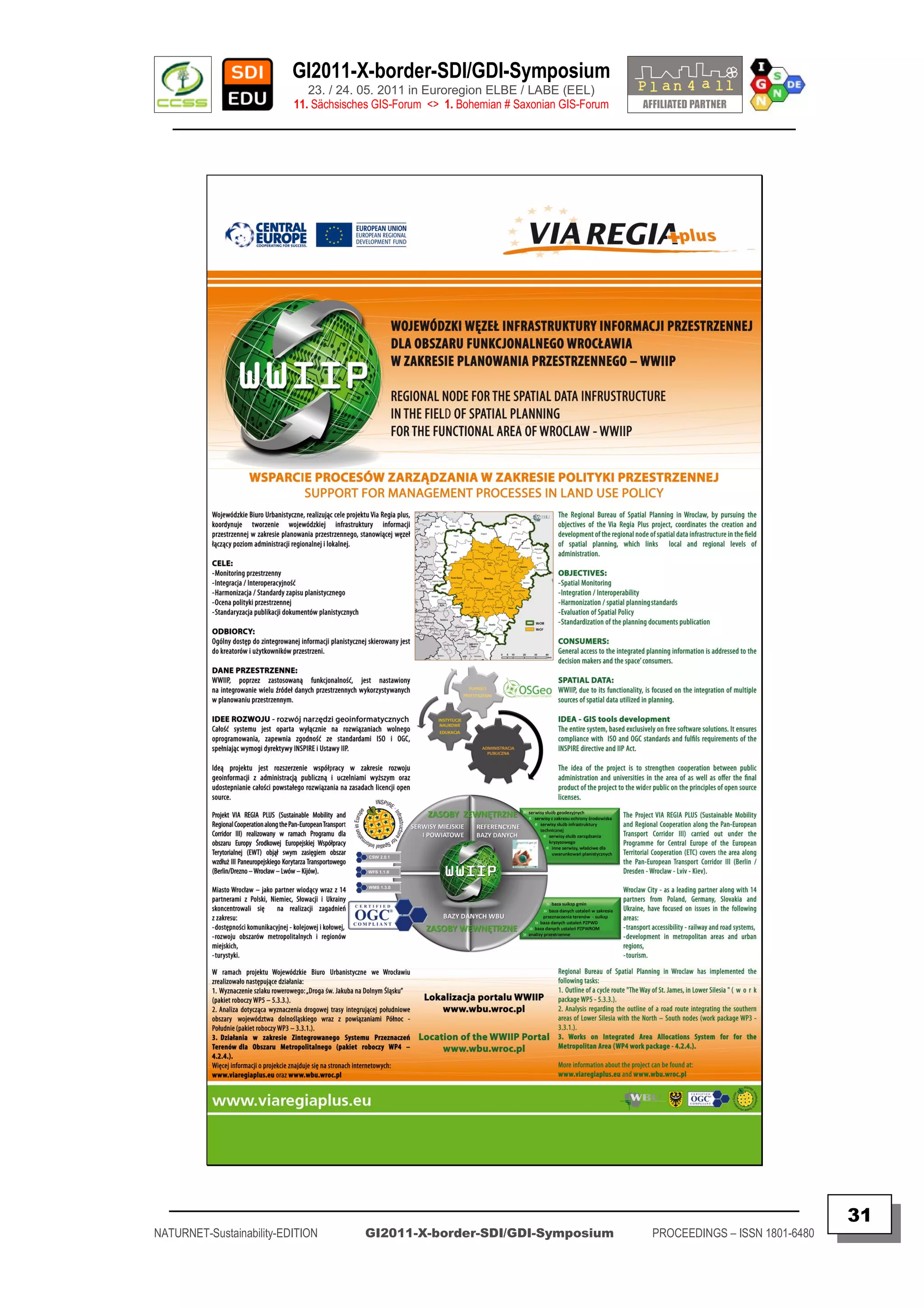
THE REGIONAL SDI NODE IN SPATIAL PLANNING FOR
THE FUNCTIONAL AREA OF WROCLAW – WWIIP
SUPPORT FOR MANAGEMENT PROCESSES IN LAND USE POLICY
Jan BLACHOWSKI & Przemysław MALCZEWSKI
Dolnoslaskie Voivodeship Marshal's Office, Spatial Planning Regional Bureau Wroclaw (PL)
ABSTRACT + POSTER
Keywords: Regional SDI Node, Via Regia Plus, Inspire, Spatial planning
Contents:
PROJECT “VIA REGIA PLUS” INFO
The Project VIA REGIA PLUS (Sustainable Mobility and Regional
Cooperation along the Pan-European Transport Corridor III) carried out under the
Programme for Central Europe of the European Territorial Cooperation (ETC) covers
the area along the Pan-European Transport Corridor III (Berlin / Dresden - Wroclaw -
Lviv - Kiev).
Wroclaw City - as a leading partner along with 14 partners from Poland,
Germany, Slovakia and Ukraine, have focused on issues in the following areas:
transport accessibility - railway and road systems,
development in metropolitan areas and urban regions,
tourism.
The Regional Bureau of Spatial Planning in Wroclaw has implemented the
following tasks:
Outline of a cycle route "The Way of St. James, in Lower Silesia" (work
package WP5 - 5.3.3.).
Analysis regarding the outline of a road route integrating the southern areas of
Lower Silesia with the North – South nodes (work package WP3 - 3.3.1.).
Works on Integrated Area Allocations System for for the Metropolitan Area
(WP4 work package - 4.2.4.).
More information about the project can be found at:
[ http://www.viaregiaplus.eu ] and [ http://www.wbu.wroc.pl ]
_________________________________________________________________________________________
30
NATURNET-Sustainability-EDITION GI2011-X-border-SDI/GDI-Symposium PROCEEDINGS – ISSN 1801-6480](https://image.slidesharecdn.com/gi2011proceedingsv5final-110705072117-phpapp02/75/GI2011-proceedings-v5-final-30-2048.jpg)
![GI2011-X-border-SDI/GDI-Symposium
23. / 24. 05. 2011 in Euroregion ELBE / LABE (EEL)
11. Sächsisches GIS-Forum <> 1. Bohemian # Saxonian GIS-Forum
________________________________________________________________________________________
DATA CIRCULATION SCHEME
WWIIP - GIS TOOLS DEVELOPMENT
The idea of the project is to strengthen cooperation between public
administration and universities in the area of as well as offer the final product of the
project to the wider public on the principles of open source licenses. All project
products has GNU GPL v3 license.
DEVELOPING SCHEME
Authors
Magdalena Belof, Jan Blachowski, Przemysław Malczewski
Reference
Outline of a cycle route “The Way of St. James, in Lower Silesia”
http://www.wbu.wroc.pl/4.2.4/
Contact
Regional Bureau of Spatial Planning, Dolnoslaskie Voivodeship Marshal's Office
ul. Swidnicka 12-16, 50-068 Wroclaw, Poland,
phone: 0048 71 343 79 46
fax : 0048 71 344 52 45
Email:
[ jblachowski@poczta.wbu.wroc.pl ] + [ pmalczewski@poczta.wbu.wroc.pl ]
_________________________________________________________________________________________
33
NATURNET-Sustainability-EDITION GI2011-X-border-SDI/GDI-Symposium PROCEEDINGS – ISSN 1801-6480](https://image.slidesharecdn.com/gi2011proceedingsv5final-110705072117-phpapp02/75/GI2011-proceedings-v5-final-33-2048.jpg)
![GI2011-X-border-SDI/GDI-Symposium
23. / 24. 05. 2011 in Euroregion ELBE / LABE (EEL)
11. Sächsisches GIS-Forum <> 1. Bohemian # Saxonian GIS-Forum
________________________________________________________________________________________
HS-LAYERS AND PYWPS COMPONENTS FOR SPATIAL
DATA NETWORKING INFRASTRUCTURE
Jachym CEPICKY & Karel CHARVAT
Help Service Remote Sensing – Benesov (CZ)
ABSTRACT
Keywords: INSPIRE, Geoportal, View Services, Processing Services
Contents:
HSLayers combines capabilities of ExtJS and OpenLayers and several helping scripts to
establish truly Web GIS applications. The development started in 2007. In 2009, after 2 years of
development, it was released under conditions of GNU General Public License 3. HSLayers features are
coming up from OpenLayers.
HSLayers additional functions: Dynamic adding of OGC (Open Geospatial Consortium)
services into map - clients for WMS and WFS, Portrayal of independent data sources on the client side.
Map composition is composed on the basis of requests to various servers.
It is thus not necessary to install a map server, saving of map composition according
to WMC (Web Map Context) OGC specification on user computer for repeated future use or for
sharing between users, Extension of compute functions based on WPS (Web Processing
Service) OGC service according to user needs, Multilingual environment, Map requests to
various types of data stored on various servers, with automatic processing of results, Work with
micro-formats, Search on the map, Connection of the application with catalogue client (OGC
CSW) in the geoportal, which enables display of the searched service from catalogue directly on
the map, Edit function by snapping to chosen layers, Possibilities for advanced configuration of
user requests, Advanced measuring of length and surfaces, Print of map compositions with
possible of large print outs (up to A0 format), and finally, user configuration of print settings
The important new issue is support for Web Map Context (WMC). Web Map Context (WMC)
describes how to save a map view comprised of many different layers from different Web Map Servers.
This mechanism is valuable for efficiently communicating across shift transitions.
PyWPSW is an implementation of the Web Processing Service of the Open Geospatial
Consortium in Python. With PyWPS, it is possible to provide functionalities of geographic information
systems and other space-related software via Internet.
The main advantage of PyWPS is, that it has been written with native support for GRASS-
GIS. Access to GRASS modules via web interface should be as easy as possible. Currently PyWPS is
used also with other platforms.
Authors
JACHYM CEPICKY & KAREL CHARVAT,
HSRS (Help Service Remote Sensing)
References
[ http://www.bnhelp.cz]
[ http://dev.bnhelp.cz/trac/hslayers ] + [ http://pywps.wald.intevation.org ]
Contact
Help Service Remote Sensing
Vnoučkova 614, 25601 Benešov, +420 317 724 620
tel. +420 604 617 327 | mob. +420 317 724 620
Email: [ bnhelp@bnhelp.cz ]
_________________________________________________________________________________________
34
NATURNET-Sustainability-EDITION GI2011-X-border-SDI/GDI-Symposium PROCEEDINGS – ISSN 1801-6480](https://image.slidesharecdn.com/gi2011proceedingsv5final-110705072117-phpapp02/75/GI2011-proceedings-v5-final-34-2048.jpg)
![GI2011-X-border-SDI/GDI-Symposium
23. / 24. 05. 2011 in Euroregion ELBE / LABE (EEL)
11. Sächsisches GIS-Forum <> 1. Bohemian # Saxonian GIS-Forum
________________________________________________________________________________________
HABITATS - CROSS BORDER DATA
HARMONIZATION OF PROTECTED AREAS FOR
TOURISM PURPOSES
Karel CHARVAT & Jachym CEPICKY – Help Service Remote Sensing – Benesov (CZ)
Premysl VOHNOUT – Czech Centre for Science and Society – Praha (CZ)
ABSTRACT
Keywords: Habitats, Biotops, Sea regions, Data Harmonisation INSPIRE, Geoportal,
Tourism, Social Validation, Social Networks.
Abstract:
The HABITATS extends user-centric, co-design approaches into the arena of standards
design and adoption processes, considering standards initiatives such as INSPIRE, OGC, UNSDI to be
significant social, economic and institutional innovations. The elements of approach are maintained,
applying the model at all levels from the global scale of the to the local and regional policies that frame
many HABITATS validation pilots. Community building activities follow a Web 2.0 approach to
capture the knowledge in active user communities with a strong interest in contributing to the standards
development process.
The main paradigm for HABITATS is not “What we would like to build” or “How we would
like to build”, but it is “Why?” (we need to build INSPIRE architecture, we need to harmonise data).
Only answering on such question could help and really attract local stakeholders to the implementation of
INSPIRE. Only, if we are able answer on such questions, we can see real profit from INSPIRE for local
and regional players. One application from economical segment, which was recognised by HABITATS
and which can profit from environmental data harmonization could be tourism.
Harmonized data could make easier sharing local environmental data in tourist systems. There
exists set of tasks recognised by HABITATS like choice of most promising tourism routes – including
water sports and diving, according to the season and habitat diversity of the area, users – tourism
agencies, holders of local guest houses and hotels, local municipalities.
As the coastal region encompasses also protected areas (Natura 2000) with limited allowed
actions the knowledge on location of habitats and their value is essential for all types of economical
activities. Any stakeholder involved in mentioned processes should be aware of the habitats‟ status in the
respective area. Besides, the same knowledge is necessary for the authorities as ministries, environmental
boards and coastal municipalities as the economical activities should be overseen and regulated to ensure
sustainable management of the natural resources. So the first group of target communities, although
diverse, is strongly nationally based.
Taking into account the cross-border nature of any marine processes the data on habitat
situation is relevant also for the countries sharing the Baltic Sea area. This could also bring direct profit
to ICT application developers. Having standardised services could extended applications among regions.
Authors
Karel CHARVAT & Jachym CEPICKY – HSRS (Help Service Remote Sensing)
Premysl VOHNOUT – CCSS (Czech Centre for Science and Society)
References
[ http://www.habitats.cz ] + [ http://www.inspiredhabitats.eu ] + [ http://inspiredhabitats.ning.com ]
Contact
Help Service Remote Sensing
Vnoučkova 614, 25601 Benešov, +420 317 724 620
tel. +420 604 617 327 | mob. +420 317 724 620
Email: [ bnhelp@bnhelp.cz ]
_________________________________________________________________________________________
35
NATURNET-Sustainability-EDITION GI2011-X-border-SDI/GDI-Symposium PROCEEDINGS – ISSN 1801-6480](https://image.slidesharecdn.com/gi2011proceedingsv5final-110705072117-phpapp02/75/GI2011-proceedings-v5-final-35-2048.jpg)
![GI2011-X-border-SDI/GDI-Symposium
23. / 24. 05. 2011 in Euroregion ELBE / LABE (EEL)
11. Sächsisches GIS-Forum <> 1. Bohemian # Saxonian GIS-Forum
________________________________________________________________________________________
ENVIROGRIDS TOWARDS "BLACKSEA" CACHMENT REGIONS –
CROSS-BORDER SDI FOR WATER AND LAND MANAGEMENT
Karel CHARVAT & Premysl VOHNOUT
Czech Centre for Science and Society – Praha (CZ)
ABSTRACT
Keywords: GEOSS, INSPIRE, Black See, Catchment, Uniform Resource
Management, Metadata, OGC, Catalogue, Web Map Setrvices, Web Map Context, Web
Feature Servicies, GRID Computing, Content Management System.
Abstract:
The enviroGRIDS project is contributing to the Global Earth Observation System of Systems
(GEOSS) by promoting the use of web-based services to share and process large amounts of key
environmental information in the Black Sea catchment. The main aim of the project is to assess water
resources in the past, the present and the future, according to different development scenarios.
The objective is also to develop datasets that are compatible with the European INSPIRE
Directive on spatial data sharing across Europe. The data and metadata gathered and produced on the
Black Sea catchment are distributed through the enviroGRIDS geoportal. The challenge is to convince
and help regional data holders to make their data and metadata available to a larger audience in order to
improve our capacity to assess the sustainability and vulnerability of the environment.
EnviroGrids focuses on building the capacity of scientific community to assemble such a
system in the Black Sea Catchment and one of the goals of this project is the development of a web
platform for knowledge dissemination that will also enable citizens‟ active and collaborative participation
in environmental resources management, with emphasis on fresh-water resources through integrated
River Basin Management.
The EnviroGrids portal was initially presented as Uniform Resource Management (URM),
Current concept include not only basic URM tools, but also interaction with Social Media. The current
Geoportal has to offer services supporting the creation of a spatial data sharing system with possibility
to publish data for any user having access to Web. The system is based on open formats and is open for
interaction with other SDI platforms. It could be used in education, but also could be a solution for
researchers, voluntary initiatives and data providers, and supports also GEOSS principles.
The EnviroGrids portal is a new integrated solution being designed as a combination of
previous technologies – Uniform Resource Management, Geohosting and new technological development
of a visualization client based on HSLayers - OpenLayers+ExtJS mapping framework.
The URM Geoportal is not the one integrated solution, but a set of modules and services,
which are able to communicate through interoperable services (OGC, W3C). The solution is modular and
could be easily modified for different purposes The URM models currently integrate different tools,
which support sharing of knowledge. The Geoportal contains common metadata and catalogue, data
sharing and visualization functionalities.
Authors
Karel CHARVAT & Premysl VOHNOUT
CCSS (Czech Centre for Science and Society) – Praha (CZ)
References
[ http://www.envirogrids.cz ] + [ http://www.envirogrids.net ]
Contact
Czech Centre for Science and Society
Radlicka 28; 150 00 Praha 5
tel. +420 604 617 327 | mob. +420 604 617 327
Email: [ ccss@ccss.cz ]
_________________________________________________________________________________________
36
NATURNET-Sustainability-EDITION GI2011-X-border-SDI/GDI-Symposium PROCEEDINGS – ISSN 1801-6480](https://image.slidesharecdn.com/gi2011proceedingsv5final-110705072117-phpapp02/75/GI2011-proceedings-v5-final-36-2048.jpg)
![GI2011-X-border-SDI/GDI-Symposium
23. / 24. 05. 2011 in Euroregion ELBE / LABE (EEL)
11. Sächsisches GIS-Forum <> 1. Bohemian # Saxonian GIS-Forum
________________________________________________________________________________________
SDI - THE PYRAMID OR SPIDER NETWORK
Karel CHARVAT & Premysl VOHNOUT
Czech Centre for Science and Society – Praha (CZ)
ABSTRACT
Keywords: GEOSS, INSPIRE, GMESS, SDI, Social Media, Voluntary initiatives,
Cross-border applications.
Abstract:
Global SDI building is usually described like the pyramid building. Current experiences
demonstrate, that for practical usage is more efficient the “spider net infrastructure”, where different
local or global levels are able to share data directly. As examples could be mentioned cross border
systems, systems of different communities across Europe or World, etc.
A 4th way to SDI is the way to shift from the pyramid paradigm, to paradigm of spider net.
Connected with our concept is the system of distributed data sources, where every provider could decide
about accessibility of his data against concept of cloud computing, where one organisation is managing
all information.
The principle of “Geoportal4everybody” (G4E) allows to build a "spidernet" infrastructure
supporting interconnection of any two portals and effective exchange of information. This concept is also
more related to GEOSS principles.
Our Geoportal solutions support two approaches. It offer possibility of publishing user
derived data on community portal, but also sharing information using metadata catalogues with other
portals. It also offers connection with public portal and re-use of information on public portals. It
supports also easy integration of such information sources like OpenStreetMap. With the development of
new desktop solutions, it is possible also connecting the whole infrastructure from desktop solutions.
This depends on the ability of desktop systems to implement OGC standards and also eventual catalogue
functionality.
The new functionality of G4E also includes aspects of social network. A social network
consists of a finite set or sets of actors and the relation or relations defined on them. The presence of
relational information is a critical and defining feature of a social network. The focus of the URM
Geoportal project is on social network sites (e.g LinkedIn, Facebook, Twitter) as one of the main
dissemination and communication tool. The Geoportal is in principle also a social network offering
sharing of information (including spatial) among its own community and offers support for information
exchange as well among thematical communities.
The Geoportal is an entry point for any news (new developments, problematic topics,
progress in the project, etc.). News are posted by the project partners and will be automatically
distributed to a number of selected communities – social network sites.
This approach will allow involving of other communities from one place without having to
enter each other community. Users of various social network sites can read entries and comment through
their respective communities and don‟t have to register elsewhere.
GeoPortal4everybody also supports utilization of information from other social networks like
SlideShare or YouTube.
Authors
Karel CHARVAT & Premysl VOHNOUT
CCSS (Czech Centre for Science and Society) – Praha (CZ)
Reference
[ http://www.egeoportal4everybody.cz ]
Contact
Czech Centre for Science and Society
Radlicka 28; 150 00 Praha 5
tel. +420 604 617 327 | mob. +420 604 617 327
Email: [ ccss@ccss.cz ]
_________________________________________________________________________________________
37
NATURNET-Sustainability-EDITION GI2011-X-border-SDI/GDI-Symposium PROCEEDINGS – ISSN 1801-6480](https://image.slidesharecdn.com/gi2011proceedingsv5final-110705072117-phpapp02/75/GI2011-proceedings-v5-final-37-2048.jpg)
![GI2011-X-border-SDI/GDI-Symposium
23. / 24. 05. 2011 in Euroregion ELBE / LABE (EEL)
11. Sächsisches GIS-Forum <> 1. Bohemian # Saxonian GIS-Forum
________________________________________________________________________________________
ARCHITECTURE PERSPECTIVES OF A
PAN-EUROPEAN SDI
ESDIN – BEST PRACTICES –
TOWARDS THE EMERGING EUROPEAN LOCATION FRAMEWORK:
SPATIAL DATA INFRASTRUCTURES BEYOND SCHEMA HARMONIZATION
Arnulf CHRISTL
METASPATIAL
Keywords: architecture, best practice, ESDIN, european, framework, harmonization,
location, INSPIRE
Abstract:
The ESDIN consortium has successfully shown how data from European
NATIONAL MAPPING AND CADASTRAL AGENCIES (NMCA‟s) can be harmonized to
meet INSPIRE obligations whilst also addressing issues such as generalization, quality
evaluation, edge-matching and spatial data infrastructure (SDI) access control. In
doing so, it has laid the foundations for a European Location Framework (ELF) which
will enable cross-border information to be geographically-referenced and allow citizens,
businesses and governments to gain maximum benefit from the re-use of existing
national datasets.
All software created is available under BSD licenses, making it open in the
most permissive way. The recommendations and guidelines are scale and theme
independent and, although they focus on aggregation and the update of data for
INSPIRE Themes in Annex I, they will also be applicable to other themes.
Dieser Beitrag basiert auf den Ergebnissen des EU-Projektes
ESDIN. In Form einer Video-Demonstration werden
Erfahrungen aus dem EU-CONTENTplusProjekt ESDIN vermittelt
Verbindungen zwischen Interessengruppen gefördert
Arbeiten zur Umsetzung von INSPIRE verdeutlicht bzw. für die eigenen
Bedürfnisse in Wert gesetzt und
ESDIN-Projektergebnisse mit einem Online Viewer vorgestellt.
Author
Arnulf CHRISTL
+
Technical Coordinator of European Content Project ESDIN
References
[ http://www.metaspatial.net ] + [ http://www.ESDIN.eu ]
[ http://www.esdin.eu/search/node/arnulf%20christl ]
[ http://www.esdin.eu/project/summary-esdin-project-public-deliverables ]
Contact
[ http://www.metaspatial.net/contact.html ]
Email: [ arnulf.christl (at) metaspatial.net ]
_________________________________________________________________________________________
38
NATURNET-Sustainability-EDITION GI2011-X-border-SDI/GDI-Symposium PROCEEDINGS – ISSN 1801-6480](https://image.slidesharecdn.com/gi2011proceedingsv5final-110705072117-phpapp02/75/GI2011-proceedings-v5-final-38-2048.jpg)
![GI2011-X-border-SDI/GDI-Symposium
23. / 24. 05. 2011 in Euroregion ELBE / LABE (EEL)
11. Sächsisches GIS-Forum <> 1. Bohemian # Saxonian GIS-Forum
________________________________________________________________________________________
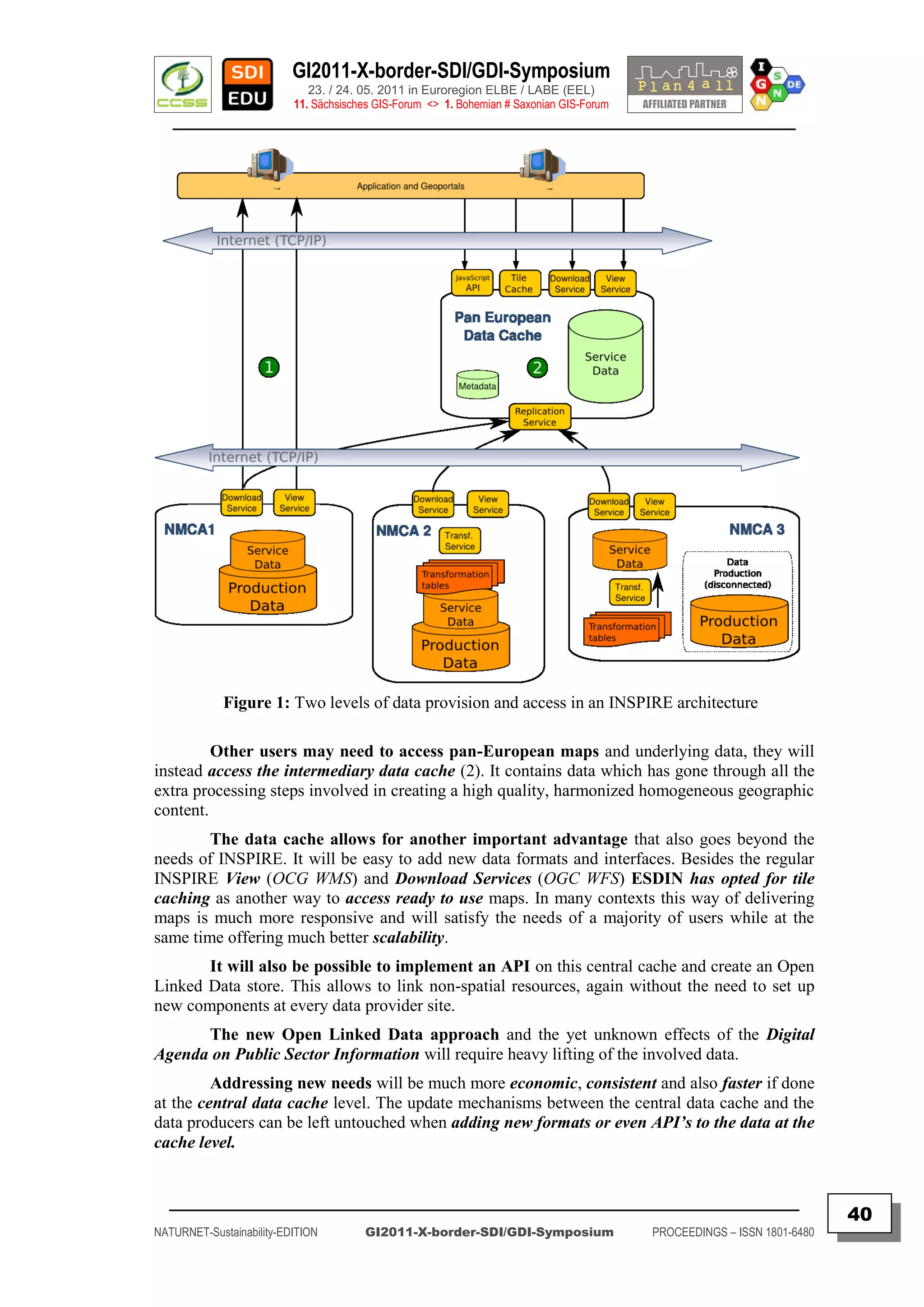
Technology and Software
ESDIN was implemented to satisfy the needs and requirements of the participating
NMCA‟s. In order to minimize disruption of existing work flows and to best leverage existing
skills NMCA‟s were free to choose whichever software they wanted. The market for INSPIRE
ready software is still fairly small, both on the serving and the consuming side.
More than ¾ of all participating NMCA’s chose to implement the publication
components of the architecture using Open Source technology. The others either used
proprietary software with special compatibility extensions, or implemented the required
components themselves.
The Open Source stack used includes the “deegree” server components in versions 2
and 3, GeoServer and MapServer. Especially the “deegree” project has gone to quite some
effort to optimize their “deegree” version 3 of the software to deliver INSPIRE download
services out of the box.
The client framework was implemented using OpenLayers with additional
extensions implemented during the project, especially to be able to use the Shibboleth
authentication federation which was set up to provide controlled access to the SDI. During the
project a lack of ready-to-use software capable of visualizing GML 3.2.1 was observed. The
obvious reason is the lack of availability of data in that format. Hopefully this will change in
future. As an alternative the ESDIN architecture is ready to accommodate extension for other
formats which can be easily hooked into the central data cache.
The tiling service delivering the EuroGeographics products EuroRegionalMap (ERM)
EuroGlobalMap (EGM) and EuroBoundaryMap (EBM) is implemented using
“GeoWebcCache”, monitoring, service tracking and metadata management during the project
was performed with “Mapbender”.
The full list of all software used during the project can be found in the Technical
Architecture document deliverable 5.2.
The way forward
Feedback from the pricing and licensing workshops, and the user insight work,
demonstrated that on-going efforts to advance “best practice” in harmonizing, accessing and
processing geographic information are needed and will be well appreciated.
It is now up to individual NMCAs, EuroGeographics and other Stakeholders to
progress and fund the creation of data and services to these specifications and therefore
complement INSPIRE with ELF.
Names and addresses are at the root of most geographical searches so these INSPIRE
themes must be the cornerstone of any proposed ELF.
The experience gained during the ESDIN project will be a helpful asset for building
and improving the architecture of the ELF. The ESDIN Consortium encourages European actors
to employ the methods outlined here in their own “best practice” towards INSPIRE compliance
and pan-European harmonization. Use the tools that have been created, experience the
demonstrations and engage with the emergent network of people and organizations that can be
used for building the ELF.
The [ VIDEO ] presentation will give some more insights to the work which has
been done in this EUROPEAN SDI NETWORK Project ( ESDIN ) !
_________________________________________________________________________________________
41
NATURNET-Sustainability-EDITION GI2011-X-border-SDI/GDI-Symposium PROCEEDINGS – ISSN 1801-6480](https://image.slidesharecdn.com/gi2011proceedingsv5final-110705072117-phpapp02/75/GI2011-proceedings-v5-final-41-2048.jpg)
![GI2011-X-border-SDI/GDI-Symposium
23. / 24. 05. 2011 in Euroregion ELBE / LABE (EEL)
11. Sächsisches GIS-Forum <> 1. Bohemian # Saxonian GIS-Forum
________________________________________________________________________________________
CZECH SOLUTION FOR INSPIRE GEOPORTAL –
THE GATEWAY TO NATIONAL SDI
Jitka FAUGNEROVÁ, Jiří KVAPIL, Jiří HRADEC – CENIA – Praha (CZ)
Jaroslav PŠENIČKA – IBM – Praha (CZ)
Štěpán KAFKA – HSRS – Benesov (CZ)
ABSTRACT
Keywords: Catalogue, Czech Republic, Dataset, Decision making, Directive, editing,
Geoportal, INSPIRE, Map viewer, Metadata, Network, monitoring, OGC, Registry,
Services, spatial validating, WMS.
Abstract:
There are two main activities supporting the implementation of the INSPIRE Directive in the
Czech Republic. These are coordinating structures forming and National INSPIRE Geoportal building.
Both are placing the cornerstone for a successful implementation: coordinating structures from the
organizational point of view, and the Geoportal from the technical one to be described.
The development of the Czech National INSPIRE Geoportal has started apart from all the
organizational issues. The main driving forces for the Geoportal are of course the requirements of the
INSPIRE directive (to make data and metadata available, to run network services, etc.), but from the
beginning its creators decided to do more, than only provide an access to data guaranteed by the state
administration.
The Geoportal is available at [ http://geoportal.gov.cz ] providing discovery and view
services. So far only following portal components are fully functional: metadata searching, metadata
editing, metadata validator, user registry, map window and monitoring. The others are being developed
according to the plan. Monitoring indicators can be easily inserted by each data provider without using
the complicated Excel template. Map viewer user interface supports OGC WMC. Each user is able to
combine services into map compositions, modify predefined ones, store the results on the Geoportal and
share them with others.
The National INSPIRE Geoportal of the Czech Republic was launched in January 2011.
The number of registered users is increasing day by day, but the overall figures are still not high enough.
Data providers are mostly aware of INSPIRE Directive and know what they are expected to provide,
however they are sometimes hesitating to make their data or services available. The GIS community is
already familiar with map services provided by many providers, they are accessing it directly using GIS
software. So the most important is to inform the public, that there some INSPIRE Directive exists and
explain what profit they can have from it. This is the biggest challenge.
Authors
Jitka FAUGNEROVÁ, Jiří KVAPIL, Jiří HRADEC
CENIA (Czech Environmental Information Agency) – Praha (CZ)
Jaroslav PŠENIČKA – IBM.cz – Praha (CZ)
Štěpán KAFKA – HSRS (Help Service Remote Sensing) – Benesov (CZ)
References
[ http://www.cenia.cz ] + [ http://inspire.gov.cz [ + [ http://geoportal.gov.cz ]
Contact
CENIA, česká informační agentura životního prostředí
Litevská 1174/8; 100 05 Praha 10
tel. +420 267 225 294 | mob. +420 724 549 970
Email: [ geoportal@CENIA.cz ]
_________________________________________________________________________________________
42
NATURNET-Sustainability-EDITION GI2011-X-border-SDI/GDI-Symposium PROCEEDINGS – ISSN 1801-6480](https://image.slidesharecdn.com/gi2011proceedingsv5final-110705072117-phpapp02/75/GI2011-proceedings-v5-final-42-2048.jpg)
![GI2011-X-border-SDI/GDI-Symposium
23. / 24. 05. 2011 in Euroregion ELBE / LABE (EEL)
11. Sächsisches GIS-Forum <> 1. Bohemian # Saxonian GIS-Forum
________________________________________________________________________________________
THE RIVER DANUBE AS A CROSS-BORDER
DEVELOPMENT DETERMINANT FOR THE CITY
OF BRATISLAVA
Juraj FURDÍK, Rostislav ONDRUŠ, Denisa ŠEBOVÁ
Faculty of Architecture, Slovak University of Technology – Bratislava (SK)
ABSTRACT – POSTER
Keywords: Austria, Hungary, Cross-border, The River Danube, Bratislava, Landuse
Planning, Water Flow, Region, Slovakia
Contents:
Historically, the River Danube protected the territory of Slovakia, and this
fact has naturally and politically demonstrated to the possibilities of the City of
Bratislava development and to the possibilities of the whole region development.
The intention of this poster presentation is to point out natural and social
determinants of the development of Bratislava territory and in the context of the impact
on the border Slovak, Austrian and Hungarian villages (city districts).
The poster presents the influence of the Danube water flow and its water
system in the evolutional (historical) context, when the voluminous system of the
starting point of the Central Europe delta – Danube mouth in the territories of Slovakia,
Hungaria and Austria presented autonomical natural and social system in the contact
with the capitals of these countries.
The poster presentation is focused on the City of Bratislava and the territory of
surrounding villages in contact with the water system of Danube river, with emphasis
on the improvement of natural and civilization conditions in the context of sustainable
territory development of this border region.
Authors
Ing. arch. Juraj FURDÍK, PhD., Mgr. Rostislav ONDRUŠ, Ing. arch. Denisa ŠEBOVÁ
Reference
[ http://www.fa.stuba.sk/generate_page.php?page_id=2358 ]
Contact
Department of Computer and Multimedia Design, Faculty of Architecture,
Slovak University of Technology – Bratislava
Námestie slobody 19, 812 45 Bratislava, Slovakia
phone: 00421 918 665 034
Email: [ furdik@fa.stuba.sk ]
_________________________________________________________________________________________
43
NATURNET-Sustainability-EDITION GI2011-X-border-SDI/GDI-Symposium PROCEEDINGS – ISSN 1801-6480](https://image.slidesharecdn.com/gi2011proceedingsv5final-110705072117-phpapp02/75/GI2011-proceedings-v5-final-43-2048.jpg)
![GI2011-X-border-SDI/GDI-Symposium
23. / 24. 05. 2011 in Euroregion ELBE / LABE (EEL)
11. Sächsisches GIS-Forum <> 1. Bohemian # Saxonian GIS-Forum
________________________________________________________________________________________
URBAN STRUCTURE TRANSFORMATION OF THE
PERIPHERAL BORDER DISTRICTS OF CITY
BRATISLAVA
Juraj FURDÍK, Ivor MEČIAR, Rostislav ONDRUŠ, Denisa ŠEBOVÁ
Faculty of Architecture, Slovak University of Technology – Bratislava (SK)
ABSTRACT – POSTER
Keywords: Cross-border, Bratislava – Čunovo, Land-Use Planning
Contents:
Development of peripheral city districts (villages) of Bratislava in the period after
1989 attained the strong dynamism at the border areas between Slovak, Hungary and Austria.
One of these city districts is Čunovo, which is unique, because its cadastral territory is
bordering directly with Hungary and Austria.
This dynamism, caused by several factors, was dominantly influenced by the opening
of borders and by the admittance of Slovakia and Hungary as Member states to the single
European Union.
The intentions and possibilities of structural transformation of the village, located
at the borders with Austria and Hungary is to preserve the suburban character, and as been
documented in several urban studies and zonal plans of Čunovo border territory.
The Poster presents in more detail urban study of zone land-use plan of the
“Area of the Former Collective Farm in Čunovo″ located in a border area.
The intention of this study is a transformation of the functional usage to the zone of
housing and manufacturing and non-productive services. Therefore, the main objective of this
study was keeping of the sustainable development of the city district by searching for its new
architectural and urban image.
Authors
Ing. arch. Juraj FURDÍK, PhD., Ing. arch. Ivor MEČIAR, ArtD.,
Mgr. Rostislav ONDRUŠ, Ing. arch. Denisa ŠEBOVÁ
Reference
[ http://www.fa.stuba.sk/generate_page.php?page_id=2358 ]
Contact
Department of Computer and Multimedia Design, Faculty of Architecture,
Slovak University of Technology – Bratislava
Námestie slobody 19, 812 45 Bratislava, Slovakia
phone: 00421 918 665 034
Email: [ furdik@fa.stuba.sk ]
_________________________________________________________________________________________
44
NATURNET-Sustainability-EDITION GI2011-X-border-SDI/GDI-Symposium PROCEEDINGS – ISSN 1801-6480](https://image.slidesharecdn.com/gi2011proceedingsv5final-110705072117-phpapp02/75/GI2011-proceedings-v5-final-44-2048.jpg)
![GI2011-X-border-SDI/GDI-Symposium
23. / 24. 05. 2011 in Euroregion ELBE / LABE (EEL)
11. Sächsisches GIS-Forum <> 1. Bohemian # Saxonian GIS-Forum
________________________________________________________________________________________
CHALLENGES AND OPPORTUNITIES FOR
EUROPEAN BORDER REGIONS
Analysis of Cross-border GeoPortals for GI/GIS/GDI & GeoINSPIRE’d Infrastructures of Data, Services and Applications
Frank HOFFMANN
IGN-Vorstandsvorsitzender – (INNOVATION. Grenzüberschreitendes Netzwerk e.V.) – DRESDEN (DE)
ABSTRACT
Keywords:
AEBR, Awareness, Border regions, BOWGIS, Education, ESDI, ETC/4A, EU-Directives, Europe, FP6/7, GDI,
Geodata, Geomatics, Geospatial, GI2000, GI2011, GSDI, INSPIRE, Interoperability, INTERREG/4A, NSDI,
OpenGIS, Pilot projects, PSI, Regions, SDI, Spatial planning, Strategy seminars, Sustainability, Usability, X-SDI.
Contents:
The GI2000 Initiative, already created and discussed intensively between 1995 and 1999 as a vision,
mission and conception for an integrated European Spatial Data Infrastructure (ESDI) process, defacto was
ready for submission just after the 5th EC GI&GIS Workshop in Stresa/Italy in summer 1999. But, unfortunately, in
December 1999 in spite of the urged demission of the European Commission the GI2000 concept was cancelled.
But, the GI2000 concept then was “re-invented” again in 2001 and promoted at EC GI&GIS workshop
2002 in Dublin as the “new”, but now as the well known INSPIRE process, officially proposed in 2004, and adopted
later on as the INSPIRE Directive 2007/2/EC.
Finally, the INSPIRE Data and Service Sharing Guidelines of the European Commission, e.g. the legal
REGULATION No 268/2010 as of 29 March 2010 have been published at April 28th 2010.
This Regulation is aiming to introduce OPEN GEODATA ACCESS conditions to spatial datasets,
information services and thematical applications (e.g. for georesource exploring, environmental monitoring and
spatial planning) not only inside of the EC institutions and agencies, but as well for regional/cross-border
organizations and local/cross-border communities in order to give them the opportunity to harmonize and integrate
geodatasets and public sector information (PSI-Directive 2003/98/EC) supplied from all Member states in an
interoperable and syntactically and semantically standardized way for environmental and spatial planning processes.
Nevertheless, the geopolitical and technical decision process to implement INSPIRE until year 2019 is
moving very slowly not only in the European Member states, but as a follow-up also in Germany, as well in Saxony.
But, the main barriers and, as well as important, challenges are the geodetic transformation, semantic
harmonization and cartomatic generalization of GEO/ENVIRO/SPATIO data and datasets and their integration
based on interoperable webservices from local via regional into national level to build a homogenous…
Infrastructure of Spatial Information across European Border Regions ( INSPIRE-X-EBR ) !
Therefore, this presentation gives an overview on the very few selected SDI, e.g. only 6-8 still existing
X-border-Geoportal initiatives, as well as X-SDI/GDI Pilot projects dealing with topometric, topological &
thematical interoperability, usability and sustainability of public & private sector geodata, webservices and
special PLAN4ALL applications across local, regional and state borders. The symposium will inform and make
aware the AEBR community of nearly 200 European Border Regions about the potential, chances and challenges
ahead when implementing the PSI & INSPIRE Directives in cross-border regions of Europe.
Author
Doz. Dr. Frank HOFFMANN, CSc
References
[ http://www.AEBR.eu/files/filemanager_files//dummy/AEBR_seminars/Vigo_2011/Presentations/Hoffmann_2011-AEBR-X-SDI-INSPIRE.pdf ]
ARCHIV: GI2010-Symposium - 10. Sächsisches GIS-Forum, Dresden 2010
[ http://epsiplatform.eu/psi_library/reports/gi2010_dresden_symposium_may_2010 ]
ARCHIV: GI2009-Symposium - 9. Sächsisches GIS-Forum, Dresden 2009
[ http://www.epsiplatform.eu/reports/gi2009_dresden_symposium_may_2009 ]
ARCHIV: GI2008-Symposium - 8. Sächsisches GIS-Forum, Dresden 2008
[ http://www.epsiplus.net/reports/gi2008_dresden_symposium_may_2008 ]
EU-FP6-Project-NATURNET [ http://www.NATURNET.org ]
GEOSPATIAL SAXONY – WEBLOG GDI-SN [ http://GDI-SN.blogspot.com ] – IGN e.V. © 2002-2011, IGN. All rights reserved.
Contact
IGN - INNOVATION. Grenzüberschreitendes Netzwerk e.V.
c/o IGN-Vorstand, Martin-Andersen-Nexö-Str. 4, D-01217 DRESDEN / Saxony / Germany
[ http://www.FACEBOOK.com/event.php?eid=163068260403141 ]
Email [ Mailto:Vorstand@IGN-SN.de ] + [ Mailto:info@GDI-SN.de ]
_________________________________________________________________________________________
45
NATURNET-Sustainability-EDITION GI2011-X-border-SDI/GDI-Symposium PROCEEDINGS – ISSN 1801-6480](https://image.slidesharecdn.com/gi2011proceedingsv5final-110705072117-phpapp02/75/GI2011-proceedings-v5-final-45-2048.jpg)
![GI2011-X-border-SDI/GDI-Symposium
23. / 24. 05. 2011 in Euroregion ELBE / LABE (EEL)
11. Sächsisches GIS-Forum <> 1. Bohemian # Saxonian GIS-Forum
________________________________________________________________________________________
LEONARDO “SDI-EDU” PROJECT AS A FRAMEWORK
FOR VOCATIONAL EDUCATION IN
EUROPEAN BORDER REGIONS
Karel JANECKA*, Jiri HIESS**, Vaclav CADA*, Radek FIALA*,
Karel JEDLICKA*, Otakar CERBA*, Jan JEZEK*, Tomas MILDORF*
*University of West Bohemia – Pilsen (CZ) & **CAGI – Prague (CZ)
ABSTRACT
Keywords: Awareness, BizBiz, contents, Directive, Geoportal, INSPIRE, learning
PSI, SDI-EDU, spatial planning, tools, vocational education,
Contents:
The paper describes the proposed version of teaching content, the universal syllabus focused
on planners around all Europe. As this came from only several countries in a limited group of experts
during the first year of SDI-EDU project, therefore, the feedback and comments from different regions,
countries, from practitioners working in spatial planning, active in regional and urban planning, from
officials, and decision makers are welcomed.
The drafted syllabuses will be in next step transformed and developed into practically useable
teaching lessons using all the SDI-EDU set of instruments and the teaching contents will be proved and
trained in partner countries for ordinary audience in the next part of project.
Getting feedbacks the syllabus could be improved and modified to maximise the synergic
effects and get the most efficient learning.
Authors
Karel JANECKA1,
Jiri HIESS2, Vaclav CADA1, Otakar CERBA1, Radek FIALA1,
Karel JEDLICKA1, Jan JEZEK1, Tomas MILDORF1
Reference
[ SDI-EDU – Deliverable “Training content selection and adoption” ]
[ http://portal.sdi-edu.zcu.cz/ ]
Contact
1
University of West Bohemia
Univerzitni 22, 30614 Pilsen, Czech Republic
phone: 00420 377 632 673
fax : 00420 377 632 602
Email: [ { kjanecka | cada | cerba | fialar | smrcek | jezekjan | mildorf | } ]@kma.zcu.cz
2
Czech Association for Geoinformation – CAGI
Novotneho lavka 5,
116 68 Prague 1 – Czech Republic
Email: [ hiess2@cagi.cz ]
_________________________________________________________________________________________
46
NATURNET-Sustainability-EDITION GI2011-X-border-SDI/GDI-Symposium PROCEEDINGS – ISSN 1801-6480](https://image.slidesharecdn.com/gi2011proceedingsv5final-110705072117-phpapp02/75/GI2011-proceedings-v5-final-46-2048.jpg)
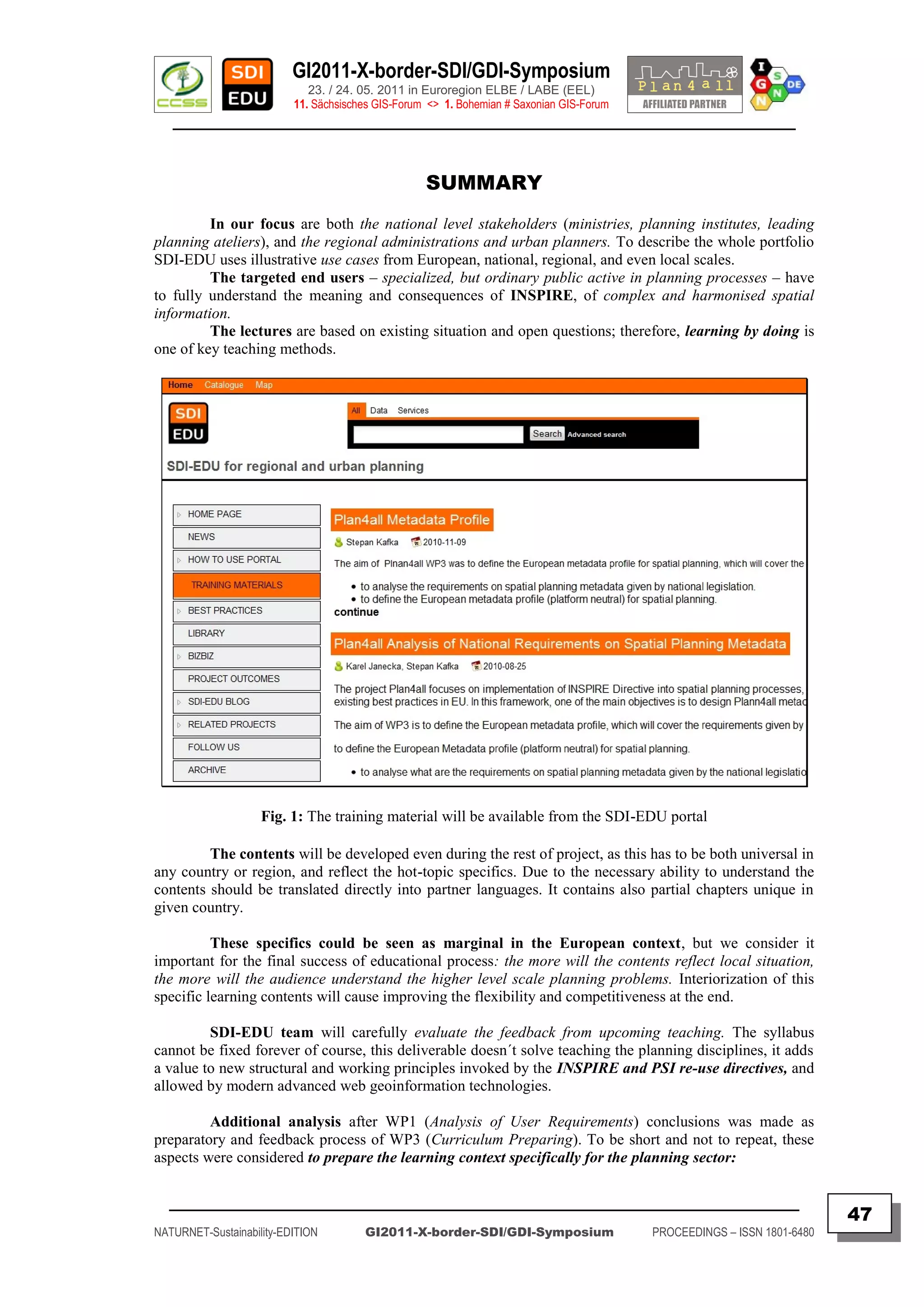
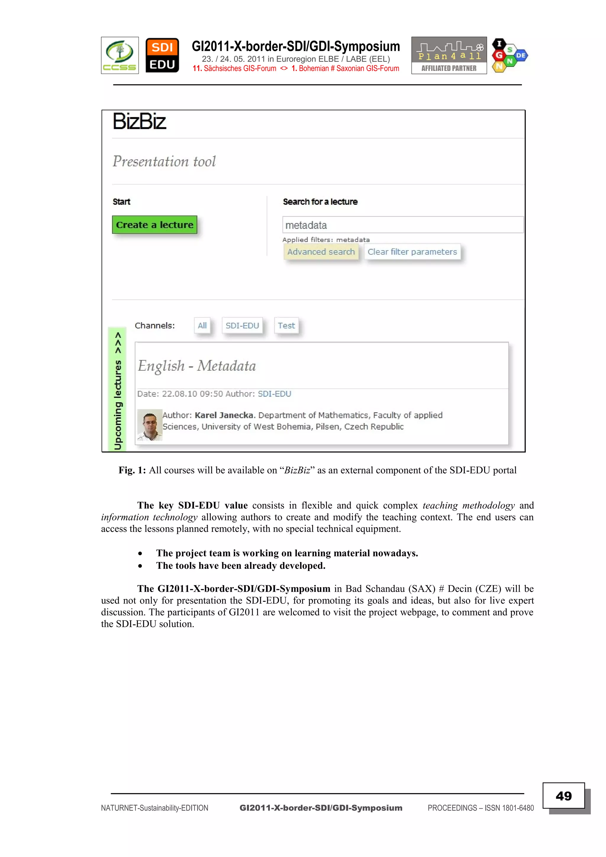
![GI2011-X-border-SDI/GDI-Symposium
23. / 24. 05. 2011 in Euroregion ELBE / LABE (EEL)
11. Sächsisches GIS-Forum <> 1. Bohemian # Saxonian GIS-Forum
________________________________________________________________________________________
SHARING METADATA ACROSS EUROPE
EXPERIENCES FROM “ONEGEOLOGY”, “HABITATS” AND “PLAN4ALL”
EUROPEAN RESEARCH NETWORKS
Stepan KAFKA – Help Service Remote Sensing – Benesov (CZ)
Karel CHARVAT – Czech Centre for Science and Society– Praha (CZ)
ABSTRACT
Keywords: Metadata, Catalogues, Metadata profiles, User communities
Abstract:
MICKA is a complex system for metadata management used for building Spatial Data
Infrastructure (SDI) and geoportal solutions. It contains tools for editing and management of metadata
for spatial information, web services and other sources (documents, web sites, etc.). It includes online
metadata search engine , portrayal of spatial information and download of spatial data to local computer.
MICKA is compatible with obligatory standards for European SDI building (INSPIRE).
Therefore it is ready to be connected with other nodes of prepared network of metadata catalogues (its
compatibility with pilot European geoportal is continuously tested). Initially, MICKA was developed as
monolithic system, but currently MICKA is a modular system divided into simple components, which
could be used independently.
Currently exist the following independent MICKA components:
INSPIRE metadata profile client for editing and validation of INSPIRE metadata
Import module for importing metadata from existing services like WMS, WCS and their editing and
validation against INSPIRE profile
Editing module for existing metadata
Light discovery catalogue client, which could be parameterized and included into different applications
Full discovery catalogue, supporting multi catalogue search
Full MICKA for Metadata administration, used only by the administrator
Harvesting of metadata
MICKA is a multilingual solution, currently translated into eighteen European languages and
it is used not only on local, regional and national level, but very often is used as well by different
European communities like geologist, spatial planners and others. These communities usually define
their own metadata profiles. As good example could be mentioned projects ONEGEOLOGY, PLAN4ALL
and HABITATS.
In ONEGEOLOGY MICKA is the central metadata catalogue describing geological data assets
held by national Geological surveys in Europe. Through the catalogue geological data and services are
discoverable across Europe. One from main objective of PLAN4ALL project was to define an overall
spatial planning metadata profile applicable for spatial plan as a whole. The PLAN4ALL metadata profile
includes not only spatial data, but also non-spatial data, relations among data sets and also time
dimension. Also the HABITATS project defines an own metadata profile as extension to the INSPIRE
profile. The HABITATS profile could be tested and validated on the HABITATS reference laboratory.
Authors
Dr. Stepan KAFKA & Dr. Karel CHARVAT
HSRS (Help Service Remote Sensing) – Benesov (CZ)
References
[ http://one.geology.cz ] + [ http://www.plan4all.eu ] + [ http://www.habitats.cz ]
Contact
Help Service Remote Sensing
Vnoučkova 614, 25601 Benešov, +420 317 724 620
tel. +420 604 617 327 | mob. +420 317 724 620
Email: [ bnhelp@bnhelp.cz ]
_________________________________________________________________________________________
50
NATURNET-Sustainability-EDITION GI2011-X-border-SDI/GDI-Symposium PROCEEDINGS – ISSN 1801-6480](https://image.slidesharecdn.com/gi2011proceedingsv5final-110705072117-phpapp02/75/GI2011-proceedings-v5-final-50-2048.jpg)
![GI2011-X-border-SDI/GDI-Symposium
23. / 24. 05. 2011 in Euroregion ELBE / LABE (EEL)
11. Sächsisches GIS-Forum <> 1. Bohemian # Saxonian GIS-Forum
________________________________________________________________________________________
TESTING OF SDI COMPONENTS – A
FUNDAMENTAL INTEROPERABILITY ELEMENT
WITHIN INSPIRE AND NATIONAL SDI’s
Tomáš KLIMENT*, Martin TUCHYŇA**, Marcel KLIMENT***
* Italian National Research Council, the Institute of Ecosystem Study (IT)
**Slovak Environmental Agency – SEA, Banská Bystrica (SK)
***Slovak University of Agriculture – SPU, Nitra (SK)
ABSTRACT
Keywords: geospatial metadata, geospatial services, INSPIRE regulations, testing
methodology, testing tools, testing reporting
Contents:
Before any Spatial Data Infrastructure (SDI) is implemented, relevant
testing procedures should take place to ensure full compliancy of all SDI components
against the standards setting up the SDI framework being deployed. Testing procedures
executed across various domains on national level can be the challenge and this
contribution comes with one example.
The INSPIRE framework defines five components: metadata, network
services, spatial data, data sharing and monitoring and reporting.
Metadata provides descriptive information about all existing resources within
SDI for the purpose of their discovery, evaluation and consumption. Metadata is served
by discovery service to the end user.
Spatial data, metadata and related network services for their discovery,
portrayal, acquisition, transformation and processing are fundamental components of
any SDI in general. Spatial data is being used for further processing within an
individual business process related to the user needs. Spatial data is visualized by view
service, accessible by download service, processed by transformation and other
processing services.
This contribution stresses the necessity of testing the above mentioned
components and provides user scenarios of cooperation between the public and
academic sector organisations. Current status and “best practices” within legally
mandated organizations (LMO) show that such cooperation is more then necessary in
order to gain required interoperability level on national and European level as well.
Authors
Dipl.-Ing. Tomáš KLIMENT &
Dipl.-Ing. Martin Tuchyňa, PhD & Dipl.-Ing. Marcel Kliment, PhD
References
[ http://www.svf.stuba.sk/docs/sjce/2010/2010_2/file2.pdf ]
[ http://gis.vsb.cz/GIS_Ostrava/GIS_Ova_2011/sbornik/papers/Kliment_theoretical.pdf ]
[ http://geo.enviroportal.sk/nipi ]
Contact
Italian National Research Council, the Institute of Ecosystem Study
Largo Tonolli 50, 28922 Verbania Pallanza, Italy,
cell phone: 0039 389 4955 954
Email: [ tomas.kliment@gmail.com ]
_________________________________________________________________________________________
51
NATURNET-Sustainability-EDITION GI2011-X-border-SDI/GDI-Symposium PROCEEDINGS – ISSN 1801-6480](https://image.slidesharecdn.com/gi2011proceedingsv5final-110705072117-phpapp02/75/GI2011-proceedings-v5-final-51-2048.jpg)
![GI2011-X-border-SDI/GDI-Symposium
23. / 24. 05. 2011 in Euroregion ELBE / LABE (EEL)
11. Sächsisches GIS-Forum <> 1. Bohemian # Saxonian GIS-Forum
________________________________________________________________________________________
BRINGING ECO-BIOLOGICAL METADATA TO THE
INSPIRE META INFORMATION WORLD
Tomáš KLIMENT & Alessandro OGGIONI
Italian National Research Council – CNR (IT)
Keywords: EnvEurope project, EML- Ecological Metadata Language, INSPIRE
metadata profile, Metadata crosswalk between EML and INSPIRE,
Abstract:
The EnvEurope project proposes a design for environmental high quality
monitoring and long-term research sites and the exemplary establishment of common
parameter sets to be collected across the largest site-based network of Long-Term
Ecosystem Research (LTER) in Europe, in 3 different types of environment
(Lacustrine, Marin and Terrestrial).
The aim of EnvEurope data management working group is to provide a
framework which allows to share the data within the project and to provide a use case
for INSPIRE/SEIS. Important part of data sharing is data discovery and evaluation by
its description. Hence, EnvEurope community metadata profile on the dataset level
using EML (Ecological Metadata Language) specification is being developed.
EML is based on prior work done by Ecological society in United States (US)
and has been developed by ecologists for ecologic discipline. It is mainly used in the US
LTER sites, and many other sites in the world (Japan, Israel, etc.). As the project
community is geographically connected with Europe an INSPIRE form of this
community metadata profile has to be taken into account to promote interoperability for
any other community in Europe.
This paper describes basic information about the construction of cross-walk
between EML metadata specification and INSPIRE metadata profile. Furthermore
provide pilot implementation of such cross-walk using XSLT technology. Moreover,
open questions and issues related mainly to the EML metadata collection using
available tools are defined for the future research work
The EnvEurope metadata profile for dataset level implementation aims on the
one hand to support a framework, where interoperable way of long term ecological and
biological data exchange across Europe and even outside of EU should be achieved.
On the other hand the activity related to dataset level metadata within the INSPIRE
Thematic Working Group for Biogeographical regions, Habitats and Biotopes and
Species Distribution (TWG HB-BR-SD) is directly supported as well.
Authors
Dipl.-Ing. Tomáš Kliment & Alessandro Oggioni, Ph.D.
Reference
[http://www.enveurope.eu/]
[ http://inspire.jrc.ec.europa.eu/index.cfm/pageid/42/list/7/id/76156 ]
Contact
Italian National Research Council, the Institute of Ecosystem Study
Largo Tonolli 50, 28922 Verbania Pallanza, Italy,
cell phone: 0039 389 4955 954
Email: [ tomas.kliment@gmail.com ]
_________________________________________________________________________________________
52
NATURNET-Sustainability-EDITION GI2011-X-border-SDI/GDI-Symposium PROCEEDINGS – ISSN 1801-6480](https://image.slidesharecdn.com/gi2011proceedingsv5final-110705072117-phpapp02/75/GI2011-proceedings-v5-final-52-2048.jpg)
![GI2011-X-border-SDI/GDI-Symposium
23. / 24. 05. 2011 in Euroregion ELBE / LABE (EEL)
11. Sächsisches GIS-Forum <> 1. Bohemian # Saxonian GIS-Forum
________________________________________________________________________________________
NOTHING – BUT A WASTE OF TIME AND MONEY?
SPECIFICITIES OF CROSS-BORDER COOPERATION
IN THE GERMAN-POLISH-CZECH BORDER TRIANGLE
Robert KNIPPSCHILD
Dresden University of Technology, Chair of Spatial Planning (DE)
ABSTRACT
Keywords: Cross-border cooperation, German-Polish-Czech border triangle,
regional development.
Contents:
Preconditions for cross-border cooperation are better than ever before. The
German-Polish-Border region has faced a rapid process of integration over the last
twenty years.
Anyhow cross-border cooperation in the field of regional development and
planning in this region is stagnating.
Why is that?
Cross-border cooperation here is characterised by specificities that require
attention within the different phases of cooperation: political legitimation, funding,
process management, evaluation.
The paper will highlight evidence from an evaluation of cross-border
cooperation in the German-Polish-Czech border triangle and will draw conclusions on
future cooperation in this region, and on requirements on future cohesion policy.
Author
Dr. Robert KNIPPSCHILD
References
Knippschild: Cross-border Spatial Planning: Understanding, Designing and Managing Cooperation
Processes in the German-Polish-Czech Borderland. In: European Planning Studies 4/2011.
Knippschild: Außer Spesen nichts gewesen? Nutzen und Erfolgsfaktoren grenzüberschreitender
Kooperation in der Stadt- und Regionalentwicklung im deutsch-polnisch-tschechischen Dreiländereck.
In: Raumforschung und Raumordnung 3 / 2009. Seiten 228-238.
Knippschild: Erklärungsansätze für erfolgreiche Kooperationsprozesse in der Stadt- und
Regionalentwicklung im grenzüberschreitenden Kontext. In: Lehrstuhl für Planungstheorie und
Stadtentwicklung RWTH Aachen: Planung neu denken online - Ausgabe I/2009.
[ http://www.planung-neu-denken.de/content/view/133/41 ]
Contact
Dresden University of Technology, Chair of Spatial Planning (DE)
phone: 0049 463335143
fax : 0049 46337745
Email: [ Robert.Knippschild@mailbox.tu-dresden.de
_________________________________________________________________________________________
53
NATURNET-Sustainability-EDITION GI2011-X-border-SDI/GDI-Symposium PROCEEDINGS – ISSN 1801-6480](https://image.slidesharecdn.com/gi2011proceedingsv5final-110705072117-phpapp02/75/GI2011-proceedings-v5-final-53-2048.jpg)
![GI2011-X-border-SDI/GDI-Symposium
23. / 24. 05. 2011 in Euroregion ELBE / LABE (EEL)
11. Sächsisches GIS-Forum <> 1. Bohemian # Saxonian GIS-Forum
________________________________________________________________________________________
COST & BENEFIT FACTORS OF REGIONAL SDI
INFRASTRUCTURES
OF WESTERN, CENTRAL AND EASTERN PART OF EUROPE
*Robert Lach & **Slawomir Anusz
*Secretary of National Contact Point of PLAN4ALL Project, IGPIM – Warsaw (PL)
** Vice-director of Institute of Spatial Economy & Housing, IGPIM – Warsaw (PL)
ABSTRACT
Keywords: Cross-border, Co-operation, Cost & Benefit Analysis of SDIs, interoperability of spatial
planning documents, state and regional/local levels cooperation, standardization of spatial planning
documetns, co-operative agreements between local and regional governments, National Spatial Planning
Concept 2030, National Strategy of Regional Development, Regional Operational Programmes, digital
spatial content, European Urban Atlas, GMES Pre-operational and (2011-13) and operational (2014-
2020) periods.
Contents:
Achievements of Advanced Regions of Europe in building and operating their SDI‟s have
been described in two technical reports of SDI Unit of DG JRC, entitled : Socio-Economic Impact of
Spatial Data Infrastructure of Catalonia (Craglia, Almirall, 2008) and Advanced Regional Spatial Data
Infrastructures in Europe (Craglia, Campagna, 2009).
Since the Government of Ukraine asked for some comparative data on impact of National and
Regional SDI’s across European Union, while preparing to approve its Law on National Geospatial Data
Infrastructure and preparing National Program of NGDI Implementation, data from 27 EU Member
States were assembled and compared, while talking on
level of development of Information Society in Europe (i2010 report),
digital cadastres implementation,
mortgage markets description (European Mortgage Federation)
and influence of cadastre, mortgage and SDIs on the development of economies of the
countries of Europe.
Comparison and dependance, by prof. Hernando DeSoto was found between development of
cadastral, mortgage systems, intellectual property and real estate rights protection – and the overall
GDP/capita of particular countries.
Having some basic data on national levels (data from National Mapping Agencies, ARSDI
Report, regional governments and central governments) a study of several regions in Poland was made,
including basic statistical, financial, organizational and legal information. Some comparative tables
were fulfilled for Western, Central and Eastern Regions of Europe. Conclusions were drawn on the basis
of external data on eventuality of coming of second wave of the World Financial Crisis.
Author
Robert LACH & Slawomir ANUSZ
Reference
Reflection on cross border cooperation in Lower Silesia, Poland
[ http://ec.europa.eu/regional_policy/opendays/CD/doc/c02.doc ]
Contact
NCP of PLAN4ALL, Institute of Spatial Economy and Housing (IGPIM)
ul. Targowa 45 03-728 Warszawa, Poland,
phone: 0048 509 791 682
Email: [ robertlach@igpim.pl ]
_________________________________________________________________________________________
54
NATURNET-Sustainability-EDITION GI2011-X-border-SDI/GDI-Symposium PROCEEDINGS – ISSN 1801-6480](https://image.slidesharecdn.com/gi2011proceedingsv5final-110705072117-phpapp02/75/GI2011-proceedings-v5-final-54-2048.jpg)
![GI2011-X-border-SDI/GDI-Symposium
23. / 24. 05. 2011 in Euroregion ELBE / LABE (EEL)
11. Sächsisches GIS-Forum <> 1. Bohemian # Saxonian GIS-Forum
________________________________________________________________________________________
GIS-SOFTWARE ACROSS AGRI APPLICATIONS AND
INTEGRATION OF BING MAPS
Walter H. MAYER
PROGIS Software GmbH, Villach / Austria
ABSTRACT
Keywords: Geographic Information Systems, GIS-Developer component, GIS based integrated
rural area management applications, AGRI-ICT, cross-border cooperation, data visualisation
Contents:
PROGIS is an Austria based GIS-Software developer and specialist for applications for rural
area management – agriculture, forestry, environment and risk-management.
PROGIS in 2010 closed a worldwide cooperation with Microsoft BING. Since then, Bing Maps
are embedded into the complete range of PROGIS technologies and can be used at click bases (for sure
also other images can be processed by PROGIS systems). In 2010 MS started to fly on new, Europe and
US to generate ortho-images with 30 cm resolution. The Western EU region is supposed to be finished in
June 2012.
For rural-area management tasks, PROGIS agreed with Microsoft the following special deal:
Bing Maps in 30 cm resolution embedded into PROGIS technology can be used by all rural-area players
for a special flat rate price for the next 4 years and may be shared amongst them.
A triple advantage – an extremely cheap flat rate for Bing Maps - divided with different users
gives a negligible price for images - embedded into an easy to use, easy to learn, powerful and cost
efficient GIS software WinGIS® and the complete range of applications across agri- and other thematical
sectors.
Why are Maps important?
Current, accurate and complete maps and geodata are quintessential for most, if not all, agro-forest-
environment-risk projects.
Public and Private Organizations (GO/NGO) need geodata for project definition, problem and risk
assessment, project approval,
Farmers and farmers organizations need geodata for project planning and project execution,
Chain partners need geodata for status and progress tracking, project monitoring and supervision (incl.
fraud detection)
Application and database developers need geodata for visualizing their data.
Why is PROGIS-ICT-technology important?
GIS WinGIS® – AXWinGIS® for processing BING maps - to build up base maps of farms and regions -
to develop own applications with the development component – to visualize data.
AGRO-applications “AGROffice-DokuPlant and FORESTOffice” for planning, processing, documentation
and control of all activities within agriculture & forestry and advisory services support.
Rural-Logistics “mobGIS” for organizing and optimizing logistic processes of large farms - and small
holder cooperatives (group needs - advisors)
Precision farming “GIS-ISO-module, ISOBUS-communication” to benefit from sensor networks, to
optimize machine usage, to manage the environment and risks – also cross-border!
Author
Dipl.-Ing. Walter H. Mayer
Reference
[ http://www.progis.com/de/ ]
[ http://www.progis.com/de/?id=gisMS_Bing_Maps.html ]
Contact
PROGIS Software GmbH, Postgasse 6, A-9500 Villach
phone: +43 4242 26332, fax : +43 4242 26332 7
Email: [ mayer@progis.com ]
_________________________________________________________________________________________
55
NATURNET-Sustainability-EDITION GI2011-X-border-SDI/GDI-Symposium PROCEEDINGS – ISSN 1801-6480](https://image.slidesharecdn.com/gi2011proceedingsv5final-110705072117-phpapp02/75/GI2011-proceedings-v5-final-55-2048.jpg)
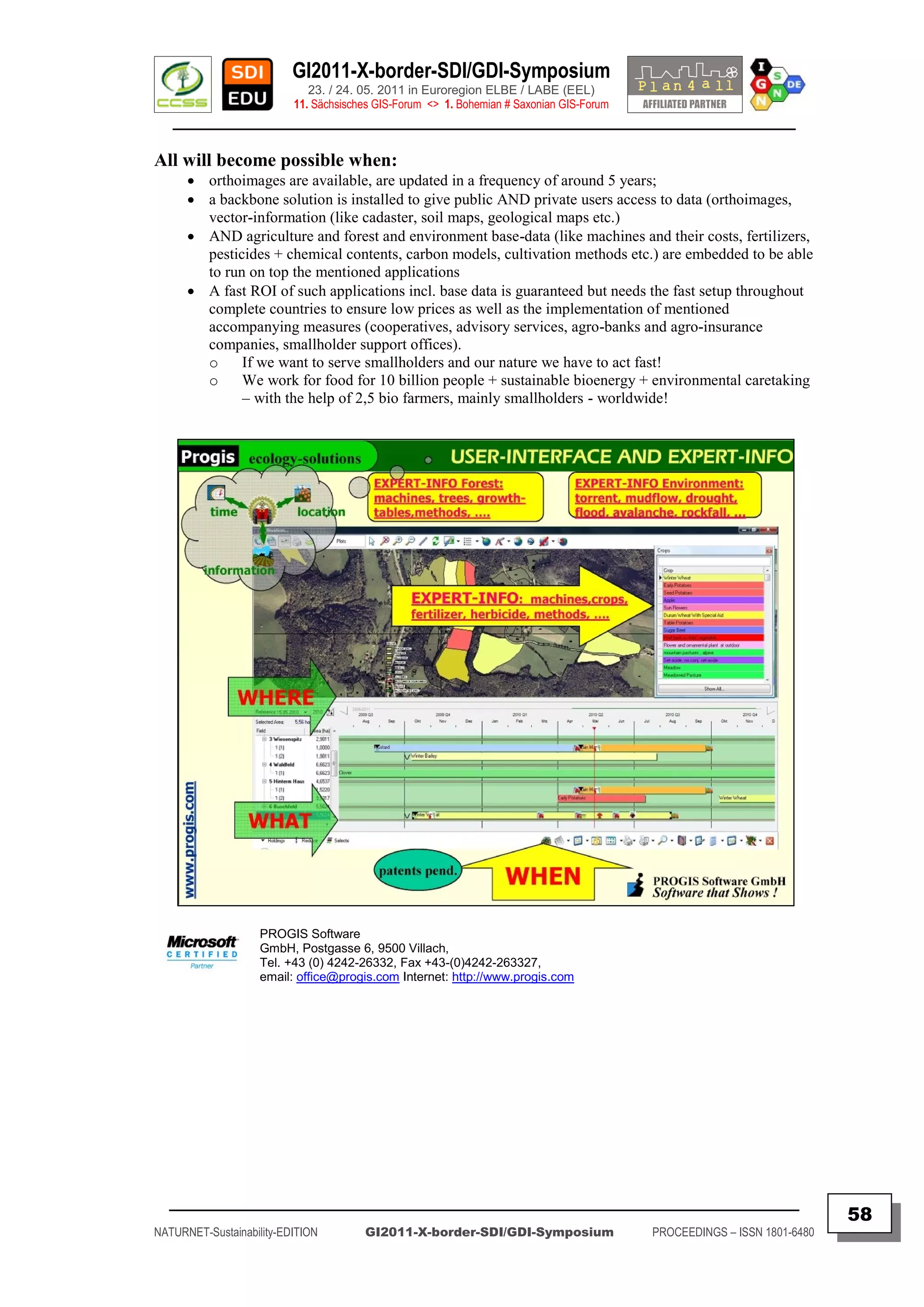
![GI2011-X-border-SDI/GDI-Symposium
23. / 24. 05. 2011 in Euroregion ELBE / LABE (EEL)
11. Sächsisches GIS-Forum <> 1. Bohemian # Saxonian GIS-Forum
________________________________________________________________________________________
SPATIAL PLANNING IN EUROPE – A CHALLENGE OR A
PIECE OF CAKE?
Karel JANECKA, Tomas MILDORF, Vaclav CADA, Karel JEDLICKA,
Otakar CERBA, Jan JEZEK, Radek FIALA
University of West Bohemia – Department of Mathematics, Section of Geomatics (CZ)
ABSTRACT
Keywords: SDI, best practices, harmonisation, interoperability, INSPIRE, spatial planning
Contents:
The European project Plan4all is co-funded by the Community programme
eContentplus. The main aim of the project is to harmonise spatial planning data and related
metadata according to the INSPIRE principles.
The Plan4all project should contribute to the standardisation in the field of spatial data
from a spatial planning point of view. Its activities and results are becoming a reference
material for the INSPIRE initiative; especially for data specifications.
Plan4all is focused on the following 7 spatial data themes as outlined in Annex II and
III of the INSPIRE Directive:
Land cover
Land use
Utility and Government services
Production and industrial facilities
Agricultural and aquaculture facilities
Area management/restriction/regulation zones and reporting units
Natural risk zones
The Plan4all project has finalised standards that are in line with the INSPIRE
Directive. These standards include European spatial planning metadata profile, data models
for the above mentioned spatial data themes and networking architecture.
This contribution should provide a general overview of these components.
We can consider that solving partial problems of spatial planning data harmonisation
can be a piece of cake. When you try to connect these pieces together, it becomes a real
challenge.
Please, visit the Plan4all geoportal to get more information about the implementation of
the Plan4all solution in pilot regions.
Authors
Tomas MILDORF,
Karel JANECKA, Vaclav CADA, Karel JEDLICKA, Otakar CERBA, Jan JEZEK, Radek FIALA
Reference
[ http://www.plan4all.eu ]
Contact
University of West Bohemia
Univerzitni 22, 30614 Pilsen, Czech Republic
phone: 00420 377 632 673
fax : 00420 377 632 602
Email: [ { kjanecka | mildorf | cada | smrcek | cerba | jezekjan | fialar }@kma.zcu.cz ]
_________________________________________________________________________________________
59
NATURNET-Sustainability-EDITION GI2011-X-border-SDI/GDI-Symposium PROCEEDINGS – ISSN 1801-6480](https://image.slidesharecdn.com/gi2011proceedingsv5final-110705072117-phpapp02/75/GI2011-proceedings-v5-final-59-2048.jpg)
![GI2011-X-border-SDI/GDI-Symposium
23. / 24. 05. 2011 in Euroregion ELBE / LABE (EEL)
11. Sächsisches GIS-Forum <> 1. Bohemian # Saxonian GIS-Forum
________________________________________________________________________________________
SUMMARY
Human activity is a term that is very often declined in conjunction with social,
political, economic and environmental issues. Spatial planning is one of the most important
areas that strongly influence these issues on all levels. Sustainable planning addresses the
environment where people live and work, the location of social and economic activities, the way
in which the resources we possess are exploited, etc. Spatial planning acts in bottom-up and top-
down directions between all levels of government. National, regional and local authorities face
important challenges in the development of territorial frameworks and concepts every day.
Spatial planning refers to the methods used by the public sector to influence the
distribution of people and activities in spaces of various scales. There are several definitions of
spatial planning. One of them is mentioned in the European Regional/Spatial Planning
Charter (1983) that was adopted by the European Conference of Ministers responsible for
Regional Planning (CEMAT): Regional/spatial planning gives geographical expression to the
economic, social, cultural and ecological policies of society. It is at the same time a scientific
discipline, an administrative technique and a policy developed as an interdisciplinary and
comprehensive approach directed towards a balanced regional development and the physical
organisation of space according to an overall strategy.
There are many challenges for spatial planning in Europe - from heterogeneity of
data to differences of planning legislations in the European countries. Infrastructure for Spatial
Information in the European Community (INSPIRE) can significantly contribute to support
spatial planning processes, especially in transboundary contexts. It should help to enhance
exchange of strategic data, to improve the use of impact assessment and evaluation of plans and
provisions in spatial planning with transparency and shared methodology.
Interoperability and harmonisation - two terms that are essential for the integration
of spatial planning information:
Interoperability means the possibility for spatial datasets to be combined, and for
services to interact, without repetitive manual intervention, in such a way that the result is
coherent and the added value of the datasets and services is enhanced. [1]
Data harmonisation - providing access to spatial data through network services in a
representation that allows for combining it with other harmonised data in a coherent way by
using a common set of data product specifications. [2]
In other words, interoperability means that each country maintains their own
infrastructure but adopts a framework that enables existing datasets to be linked up from one
country to another. Interoperability may be achieved by either changing (harmonizing) and
storing existing datasets or transforming them via services for publication in the INSPIRE
infrastructure.
The results of the PLAN4ALL project show the heterogeneity, fragmentation and
complexity of spatial planning in Europe. The Plan4all project is in the last phase of its lifetime
and using the draft INSPIRE data models will show the feasibility of data harmonisation.
PLAN4ALL project will take part in the INSPIRE testing of several spatial data themes from
Annex II and III of the INSPIRE Directive.
References
[1] Directive 2007/2/EC of the European Parliament and of the Council of 14 March 2007 establishing an
Infrastructure for Spatial Information in the European Community (INSPIRE). [Online].
Available: [ http://eurlex.europa.eu/JOHtml.do?uri=OJ:L:2007:108:SOM:EN:HTML.
[2] D2.5 Generic Conceptual model, INSPIRE Drafting Team “Data Specifications”. [Online].
Available: [ http://inspire.jrc.ec.europa.eu/reports/ImplementingRules/inspireDataspecD2_5v2.0.pdf ]
_________________________________________________________________________________________
60
NATURNET-Sustainability-EDITION GI2011-X-border-SDI/GDI-Symposium PROCEEDINGS – ISSN 1801-6480](https://image.slidesharecdn.com/gi2011proceedingsv5final-110705072117-phpapp02/75/GI2011-proceedings-v5-final-60-2048.jpg)
![GI2011-X-border-SDI/GDI-Symposium
23. / 24. 05. 2011 in Euroregion ELBE / LABE (EEL)
11. Sächsisches GIS-Forum <> 1. Bohemian # Saxonian GIS-Forum
________________________________________________________________________________________
DEVELOPMENT OF A DECISION SUPPORT SYSTEM FOR
TRANSBOUNDARY LAKE “CONSTANCE” WITH THE GENESIS
PROJECT FRAMEWORK
Stefan MIRBACH & Ulrich LANG
Ingenieurgesellschaft Prof. Kobus und Partner GmbH, Stuttgart (DE)
ABSTRACT
Keywords: Cross-border, Lake Constance, Decision support system, FP7, GENESIS Project
Contents:
Lake Constance is a transboundary lake shared between Germany, Switzerland and
Austria and the important drinking water reservoir. More than 4 Mio inhabitants are supplied
by the clean lake water without considerable treatment. In recent years a comprehensive
information system called BodenseeOnline was developed in a cooperative research project.
BodenseeOnline provides a wide range of historical as well as up-to-date data, which can be
accessed via a web interface:
daily updated measurement data on meteorological and hydrological parameters all
around the lake,
data from weather forecasts for the next 78 hours,
three dimensional distribution of hydrophysical and biogeochemical parameters
simulated by numerical models.
The models are updated daily and driven with actual data as well as data from
weather forecasts, which allow a prognosis for the next 78 hours.
To enhance the ability of BodenseeOnline to serve as a decision support system, the
GENESIS Project framework is used. Relying on standards and in strong synergy with the
major European or global harmonization initiatives (e.g. INSPIRE), this framework is based
on a thematic-neutral collaborative framework, made of web services, portal components and
toolkits, which can be customized and deployed for two thematic fields of water and air
quality.
This paper presents the integration of the data from BodenseeOnline to GENESIS
and the set-up of a decision support service using GENESIS. In case of an accident with
hazardous substances in Lake Constance, this decision support service can be used by
local authorities like water suppliers for obtaining a comprehensive evaluation and
analysis of the current and predicted meteorological, hydrological and hydrodynamic
conditions.
Authors
Stefan MIRBACH & Dr. Ulrich LANG
References
FP7-Project GENeric European Sustainable Information Space for environment
[ http://www.genesis-fp7.eu/ ]
Cooperative Research Project BodenseeOnline
[ http://www.bodenseeonline.de ]
Contact
Ingenieurgesellschaft Prof. Kobus und Partner GmbH Christian Alegre
Wilhelmstraße 11, GENESIS project coordinator :
70182 Stuttgart, Germany THALES Aleniaspace, 100 Boulevard du Midi,
phone: 0049 711 237 1936 00 FR-06156 CANNES La Bocca Cedex
fax : 0049 711 237 1936 01 Phone: 0033 492 923 202
Email: [ mirbach@kobus-partner.com ] Email: [christian.alegre@thalesaleniaspace.com]
_________________________________________________________________________________________
61
NATURNET-Sustainability-EDITION GI2011-X-border-SDI/GDI-Symposium PROCEEDINGS – ISSN 1801-6480](https://image.slidesharecdn.com/gi2011proceedingsv5final-110705072117-phpapp02/75/GI2011-proceedings-v5-final-61-2048.jpg)
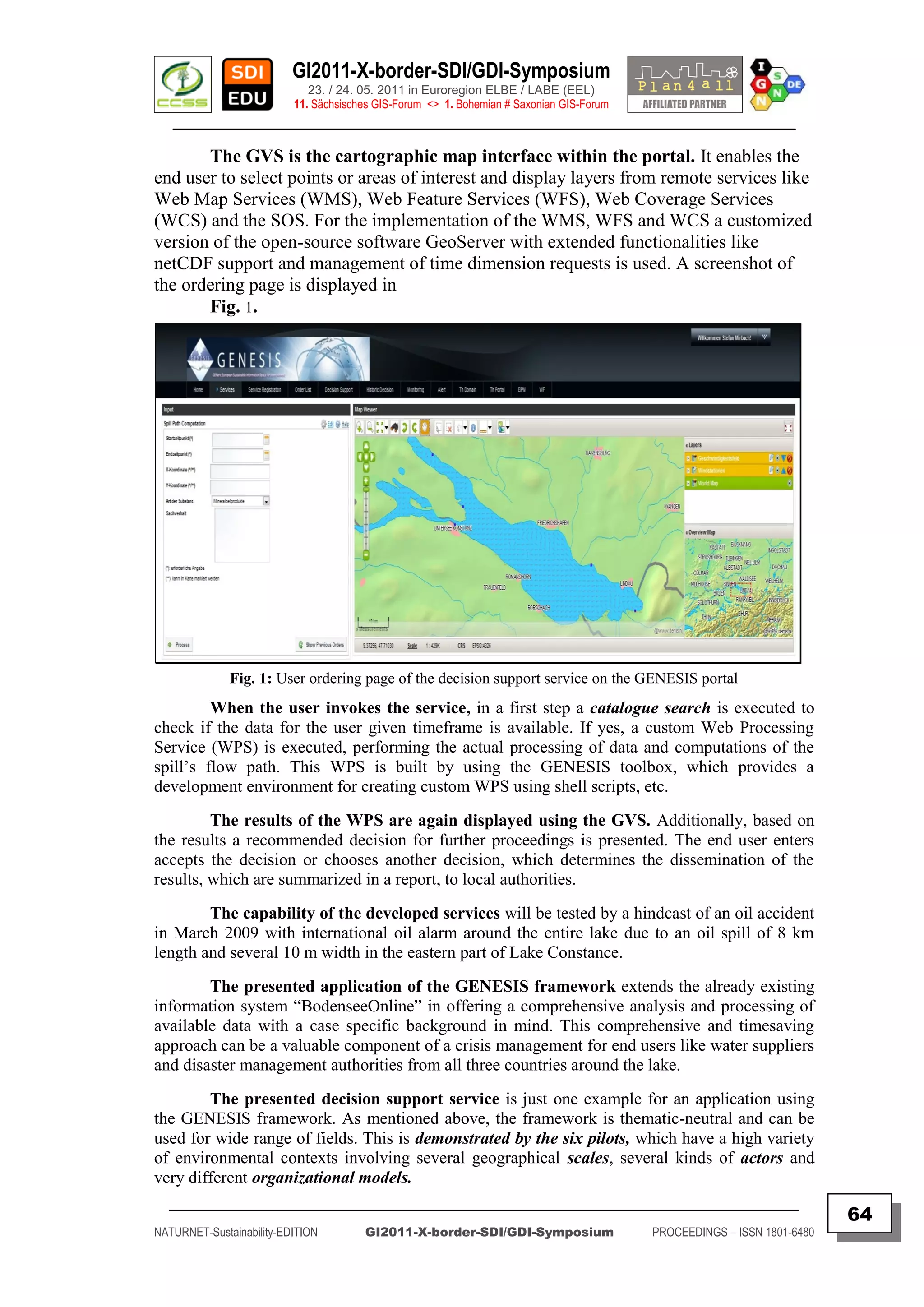
![GI2011-X-border-SDI/GDI-Symposium
23. / 24. 05. 2011 in Euroregion ELBE / LABE (EEL)
11. Sächsisches GIS-Forum <> 1. Bohemian # Saxonian GIS-Forum
________________________________________________________________________________________
CROSS-BORDER DATA HARMONISATION IN PRACTICE
– EXEMPLIFIED BY SAXON ATKIS AND CZECH ZABAGED DATA
Sylvia ROEHNERT, Claudia GEDRANGE & Marco NEUBERT
Leibniz Institute of Ecological and Regional Development, Dresden (DE)
ABSTRACT
Keywords: ATKIS, cross-border, data harmonization, spatial base data, ZABAGED
Contents:
Cross-border planning and information need homogeneous cross-border data bases.
Spatial base data as collected and provided by the respective land surveying offices offer a good
basis but refer only to the related national territory. Furthermore, they feature different
geographic projections, data formats and models, geometry (e.g. of the national boundary),
languages, and meanings of the contents.
The objective of this project is to develop methods which allow the land surveying
offices to adapt their data to be seamlessly compatible along the national boundary (geometric
homogenization) and comparable regarding their contents (semantic harmonization).
As a result methods will be developed which allow the cross-border harmonization
of spatial base data within a Geographical Information System (GIS). The implementation is
realized exemplary using vector data of the German ATKIS Basis DLM (Authoritative
Topographic Cartographic Information System, Digital Basis Landscape Model) and the Czech
ZABAGED data (Fundamental Base of Geographic Data/Základní báze geografických dat).
Both serve as the mostly used spatial base data on either side of the border.
The project is realized in cooperation with the land surveying offices of Saxony
(Staatsbetrieb Geobasisinformation und Vermessung Sachsen, GeoSN) and the Czech Republic
(Land Surveying Office/Zeměměřický úřad, ZÚ). It is funded by the European Union (Ziel 3/Cil
3 programme to support the cross-border co-operation between the Free State of Saxony and
the Czech Republic 2007-2013) and the Free State of Saxony.
The presentation will introduce the project and show the current state including first
results as well as practical outcomes regarding cross-border data harmonization.
Authors
Dipl.-Geogr. Sylvia Röhnert & Dipl.-Geogr. Claudia Gedrange & Dr. Marco Neubert
Reference
Project Website [ http://geodat.ioer.info/ ]
Contact
Leibniz Institute of Ecological and Regional Development (IOER)
Weberplatz 1, 01217 Dresden, Germany
phone: +49 (0) 351 4679-274
fax: +49 (0) 351 4679-212
Email
[ s.roehnert[at]ioer.de | c.gedrange[at]ioer.de | m.neubert[at]ioer.de ]
_________________________________________________________________________________________
65
NATURNET-Sustainability-EDITION GI2011-X-border-SDI/GDI-Symposium PROCEEDINGS – ISSN 1801-6480](https://image.slidesharecdn.com/gi2011proceedingsv5final-110705072117-phpapp02/75/GI2011-proceedings-v5-final-65-2048.jpg)
![GI2011-X-border-SDI/GDI-Symposium
23. / 24. 05. 2011 in Euroregion ELBE / LABE (EEL)
11. Sächsisches GIS-Forum <> 1. Bohemian # Saxonian GIS-Forum
________________________________________________________________________________________
SUMMARY
In a Europe of disappearing borders and especially in border regions itself a
growing demand on harmonized cross-border geodata is denoted. Harmonized geodata
facilitates cross-border spatial planning and information exchange. It enables to take
into account the situation on both sides of a border in equal measure. In addition the
needs for such data are stimulated by the INSPIRE directive of the European Union to
establish an Infrastructure for Spatial Information in European Community.
The presented project „Cross-border harmonisation of spatial base data
between the Free State of Saxony and the Czech Republic“ aims to integrate data
across the border. It is funded by the Ziel3/Cíl3-progamme of the EU which intends to
develop cross-border cooperations in the saxon-bohemian border region and the Free
State of Saxony as well.
The project is realised by three cooperation partners. The Leibniz Institute of
Ecological and Regional Development (IÖR) as Lead Partner is responsible for
scientific research and organisational steering. The cooperation with the land surveying
offices of Saxony (Staatsbetrieb Geobasisinformation und Vermessung Sachsen,
GeoSN) and the Czech Republic (Land Surveying Office/Zeměměřický úřad, ZÚ)
enables easy access and adjustments to the required data, as well as expert knowledge
about data models.
The harmonization is realised for the official spatial base data in Germany
and the Czech Republic. These data is applicable for a wide range of possible usage
options. On the one hand it is vector data of the German ATKIS Basis DLM
(Authoritative Topographic Cartographic Information System, Digital Basis Landscape
Model) in the new AAA model. On the other hand it is the Czech ZABAGED data
(Fundamental Base of Geographic Data/Základní báze geografických dat). Both data
sets are provided and actualized by the responsible land surveying offices.
Due to some similarities, concerning e.g. the acquisition scale and purpose, this
spatial base data sets offer a good basis for cross-border usage.
In contrast, differences existing in geometry (see Fig. 1), projection, language,
denotation and data model require data harmonization. Thus, the objective of this
project is the geometric and semantic harmonization.
Fig. 1 – Initial situation in the Saxon-Bohemian border region, [ http://geodat.ioer.info ]
_________________________________________________________________________________________
66
NATURNET-Sustainability-EDITION GI2011-X-border-SDI/GDI-Symposium PROCEEDINGS – ISSN 1801-6480](https://image.slidesharecdn.com/gi2011proceedingsv5final-110705072117-phpapp02/75/GI2011-proceedings-v5-final-66-2048.jpg)
![GI2011-X-border-SDI/GDI-Symposium
23. / 24. 05. 2011 in Euroregion ELBE / LABE (EEL)
11. Sächsisches GIS-Forum <> 1. Bohemian # Saxonian GIS-Forum
________________________________________________________________________________________
The geometric homogenisation presupposes:
the use of a consistent coordinate reference system,
the integration of a common border geometry and
the edge matching of cross-border objects.
The semantic harmonisation implies:
the creation of bi-lingual object type catalogues, as well as
the definition of matching functions and categories for comparing
data models.
As a first step on the way to geometrically homogeneous data an agreement
about a consistent coordinate reference system was nessesary. Orignially saxon
ATKIS data is available in RD83 with Gauss-Krüger coordinates. ZABAGED data is
projected in S-JTSK with Krovak coordinates, which is especially adapted to czech
needs [Projektbericht AP 2.1].
Both land surveying offices agreed to use ETRS89 with UTM coordinates. It
is the common reference system for Europe, defined by the INSPIRE directive
specification. Furthermore the transformation rules were adapted.
Both geodata sets currently use an inaccurate border geometry. Thus, the
surveying offices came to the agreement to use the actual valid level of common border
geometry (resulting from common border measurements).
In addition to that a set of relevant cross-border objects and especially
connecting points for edge matching were defined. Currently the edge matching is in
process. As a result the integration of a common border geometry and the connected
cross-border objects in the respective base data will be accomplished within the
project.
The semantic harmonisation approach consists of various steps. At first both
object type catalogues were translated resulting in bi-lingual object type catalogues. The
translated catalogues allowed the conceptual analysis of the data models. This analysis
revealed complex differences regarding classification and detailedness. Due to the fact
that the data is official, the data models are not changed. Thus, for harmonization the
models are integrated by alignment [ Kavouras et al. 2008 ].
To do so, all relevant combinations of object types and attribute values were
derived (ATKIS: ca. 1100, ZABAGED: ca. 310). The number of combinations is
restricted e.g. by conditions of consistency. For ATKIS only objects were used which
are maintained within Saxony (‚Bestandsdaten„).
Subsequently, matching functions for both matching directions (ATKIS to
ZABAGED and ZABAGED to ATKIS) were adjusted in a process:
At first, the cooperation partners prepared proposals.
In a second step expert meetings supported by a competent interpreter helped
to verify matching functions.
Third, matching categories were discussed and established.
The quality of matching functions is evaluated by seven categories
[ Gedrange 2011 ]:
_________________________________________________________________________________________
67
NATURNET-Sustainability-EDITION GI2011-X-border-SDI/GDI-Symposium PROCEEDINGS – ISSN 1801-6480](https://image.slidesharecdn.com/gi2011proceedingsv5final-110705072117-phpapp02/75/GI2011-proceedings-v5-final-67-2048.jpg)
![GI2011-X-border-SDI/GDI-Symposium
23. / 24. 05. 2011 in Euroregion ELBE / LABE (EEL)
11. Sächsisches GIS-Forum <> 1. Bohemian # Saxonian GIS-Forum
________________________________________________________________________________________
A – bi-unique
B – superset
C – overlap
D – subset
E – mapping to a superior object
F – derivation
G – no mapping
The frequency of the used matching categories is illustrated in Fig. 2. It applies to all
relevant combinations of object types and attribute values of both catalogues. In
addition to this fuzzy matching multiple mappings are often possible (for ATKIS to
ZABAGED 20% and for ZABAGED to ATKIS 35% of all combinations). In contrast,
to detect the matching quality in data sets itself, further analyses are nessesary.
Fig. 2 – Matching functions and categories for both directions,
including multiple mappings [ Gedrange 2011 ].
For actual results, please, visit the bi-lingual project homepage at IOER
website [ www.geodat.ioer.info ]. Further information about the harmonized base data
is provided by the geoportals of the respective land surveying offices.
References
[ Projektbericht AP 2.1 ] Gedrange, C. (2009): Bericht zum Arbeitspaket 2.1
“Festlegung eines einheitlichen Bezugssystems”, available: [ http://geodat.ioer.info ].
[ Gedrange 2011 ] Gedrange, C., Neubert, M., Röhnert, S. (2011): Cross-Border
Harmonisation of Spatial Base Data between Germany and the Czech Republic.
International Journal of Spatial Data Infrastructures Research, Vol 6.
[ Kavouras et al. 2008 ] Kavouras, M. and M. Kokla (2008). Theories of Geographic
Concepts:Ontological Approaches to Semantic Integration. CRC Press, Taylor &
Francis Group, Boca Raton, FL, USA.
_________________________________________________________________________________________
68
NATURNET-Sustainability-EDITION GI2011-X-border-SDI/GDI-Symposium PROCEEDINGS – ISSN 1801-6480](https://image.slidesharecdn.com/gi2011proceedingsv5final-110705072117-phpapp02/75/GI2011-proceedings-v5-final-68-2048.jpg)
![GI2011-X-border-SDI/GDI-Symposium
23. / 24. 05. 2011 in Euroregion ELBE / LABE (EEL)
11. Sächsisches GIS-Forum <> 1. Bohemian # Saxonian GIS-Forum
________________________________________________________________________________________
CENTROPE MAP AND CENTROPE STATISTICS – CROSS-
BORDER GEODATA INFRASTRUCTURE WITH USER-DEFINED
THEMATIC MAPS
Manfred SCHRENK*, Clemens BEYER*, Christian EIZINGER*
* CEIT ALANOVA – Central European Institute of Technology, Dept. for Urbanism, Transport, Environment &
Information Society, Schwechat (AT)
Walter POZAREK**,
** PGO - Planungsgemeinschaft Ost (East Austrian Planning Association), Vienna (AT)
ABSTRACT
Keywords: Cross-border, Web Mapping, Data Harmonisation, INSPIRE, Centrope Region
Contents:
Not long ago the only way to obtain digital geodata from different sources was to
collect offline media like CD-ROMs and then match the datasets together on your own PC like a
jigsaw puzzle. Nowadays, the situation has significantly improved. Almost each data processing
institution is providing selected data via internet services which makes it easier for the users to
retrieve the information wanted. However, these services are still mostly isolated without connections
to neighbouring countries, sometimes even lacking content from neighbouring regions within the own
country. Data beyond the administrative border is often not compatible, accessible and understandable
making cross-border activities difficult.
CentropeMAP is a cross-border geodata viewer based on the INTERREG project
Centrope and was initiated by the East Austrian Planning Organisation together with the adjacent
border regions in the Czech Republic, Slovakia, and Hungary. The main focus is on geodata relevant
for regional and cross-border spatial planning on a scale level of about 1:50,000 to 1:200,000.
Geodata is queried from individual servers within the Centrope region and collected with cascading
web map services so that the user can view the result upon a single request. CentropeMAP is an open
system able to integrate digital information from different scale levels and different sources.
CentropeMAP data itself can also be integrated in external applications via OGC WMS.
CentropeSTATISTICS extends the map portal by a large cross-border statistics database
which is also connected to the map server so that not only numbers can be seen, queried and exported,
but statistic data can also be visualised as chlorophlethic maps from NUTS 3 down to municipality
level (LAU 2). Thus, thematic maps can be generated on the fly through a user-friendly interface with
a few clicks only.
CentropeMAP and CentropeSTATISTICS follow the INSPIRE standards for the
harmonisation of spatial information in the European Community.
Authors
Dipl.-Ing. Manfred SCHRENK, Dipl.-Ing. Clemens BEYER, Dipl.-Ing. Christian EIZINGER,
Dipl.-Ing. Walter POZAREK
Reference
CentropeMAP and CentropeSTATISTICS web portal
[ http://www.centropemap.org ]
Contact
CEIT ALANOVA gemeinnützige GmbH
Concorde Business Park 2/F, A-2320 Schwechat, Austria
phone: 0043 664 854 43 90
fax: 0043 1 90360-1299
Email: [ m.schrenk@ceit.at ]
_________________________________________________________________________________________
69
NATURNET-Sustainability-EDITION GI2011-X-border-SDI/GDI-Symposium PROCEEDINGS – ISSN 1801-6480](https://image.slidesharecdn.com/gi2011proceedingsv5final-110705072117-phpapp02/75/GI2011-proceedings-v5-final-69-2048.jpg)
![GI2011-X-border-SDI/GDI-Symposium
23. / 24. 05. 2011 in Euroregion ELBE / LABE (EEL)
11. Sächsisches GIS-Forum <> 1. Bohemian # Saxonian GIS-Forum
________________________________________________________________________________________
CROSS-BORDER GIS – THE “GEOGRAPHIC
INFORMATION SYSTEM OF THE UPPER RHINE”
EXAMPLE
B. STERN
GIS Section - SIGRS/GISOR Conseil Général du Haut-Rhin - 68000 COLMAR (FR)
ABSTRACT
Keywords:
Cross-border GIS, Spatial Planning, Thematic Databases, Upper-Rhine-Valley
Contents:
The Geographic Information System of the Upper Rhine (SIGRS) aims at getting a
uniform and coherent representation of the territory of the Upper-Rhine. Within its technical
part, it produces mappings which deal with many topics (environment, land-use, statistics,
transports, energy, wealth and forecasting) from a very rich geographic French, German and
Swiss database, updated as often as possible.
At the same time, it leads many cross-border networks through the organization of
meetings, workshops and presentations. It also aims at collaborating with other European
structures that are developing similar projects and keeps up with issues raised by the European
legislation about geoinformatics (in particular the European Directive INSPIRE).
Some topics developed by the SIGRS between 2008 and 2011:
Upper-Rhine demographical evolution, transports, business parks, socio-economical indicators,
rail activity…
This paper/poster will present some thematic data workflow examples, as well as
some mapping results and the SIGRS prospect for better cross-border cooperation.
Authors
B. STERN – Y.SOULAIMANI
Reference
[ http://sigrs-gisor.org ]
Contact
Boris STERN
Cellule SIG/GIS Abteilung - SIGRS/GISOR
Conseil Général du Haut-Rhin
Adresse : 100 avenue d'Alsace
BP 20351 - 68006 COLMAR CEDEX
Tel: ++33 / 3 / 89 30 63 91
Fax: ++33 / 3 / 89 21 98 52
Email: [ stern@cg68.FR
_________________________________________________________________________________________
70
NATURNET-Sustainability-EDITION GI2011-X-border-SDI/GDI-Symposium PROCEEDINGS – ISSN 1801-6480](https://image.slidesharecdn.com/gi2011proceedingsv5final-110705072117-phpapp02/75/GI2011-proceedings-v5-final-70-2048.jpg)
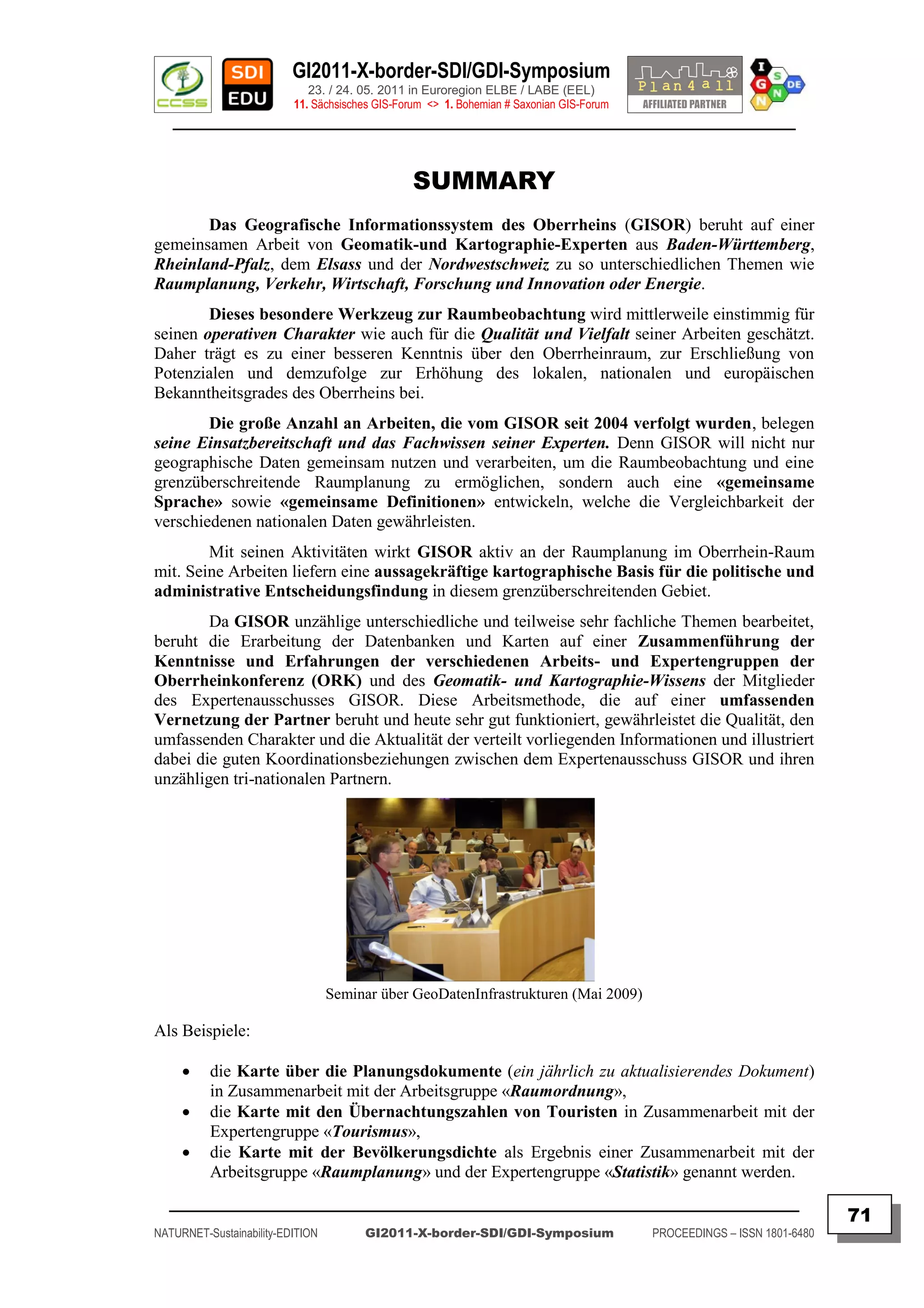
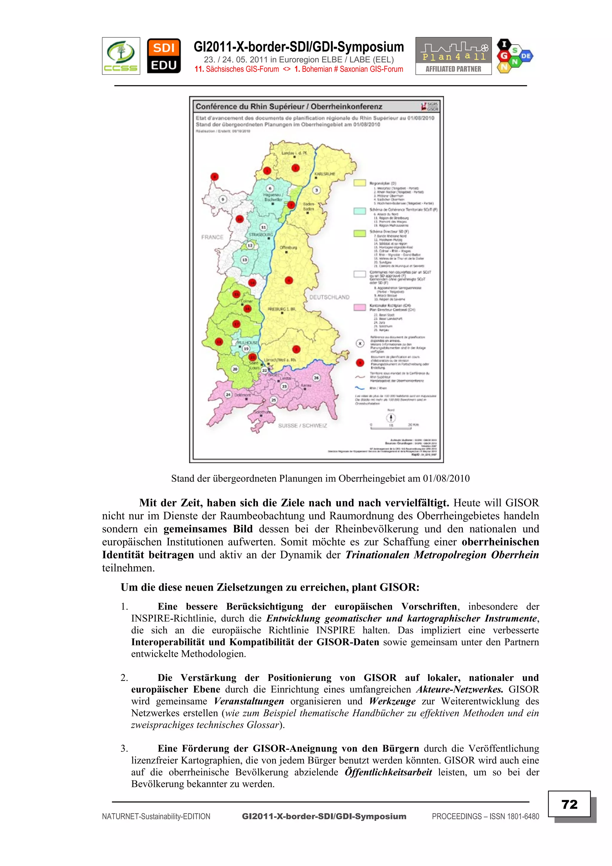
![GI2011-X-border-SDI/GDI-Symposium
23. / 24. 05. 2011 in Euroregion ELBE / LABE (EEL)
11. Sächsisches GIS-Forum <> 1. Bohemian # Saxonian GIS-Forum
________________________________________________________________________________________
GISOR-Vorstellung in Brüssel (Oktober 2010).
GISOR hat zwischenzeitlich auch seinen Nutzen bei Zukunftsanalysen bewiesen und
gehört mittlerweile zum Kern der Strategie der Trinationalen Metropolregion des
Oberrheins, die die Kenntnis unseres Grenzgebietes verbessern soll, damit es sowohl auf
nationaler als auch auf europäischer Ebene besser beworben werden kann.
Anfangs war GISOR ein technisches Instrument für die Arbeitsgruppen und
Expertenausschüsse der Oberrheinkonferenz.
Heute soll es der breiten Öffentlichkeit zugänglich gemacht werden und auf
unterschiedlichen Ebenen zum Einsatz kommen (Veröffentlichungen, internationales
Marketing, Schul- und Universitätsbereich, Vereinsleben …).
Zudem soll das derzeitige Partnernetz auf europäische Beteiligte
und Kooperationen ausgeweitet werden.
Mehr Informationen unter: [ http://ww.sigrs-gisor.org ]
_________________________________________________________________________________________
73
NATURNET-Sustainability-EDITION GI2011-X-border-SDI/GDI-Symposium PROCEEDINGS – ISSN 1801-6480](https://image.slidesharecdn.com/gi2011proceedingsv5final-110705072117-phpapp02/75/GI2011-proceedings-v5-final-73-2048.jpg)
![GI2011-X-border-SDI/GDI-Symposium
23. / 24. 05. 2011 in Euroregion ELBE / LABE (EEL)
11. Sächsisches GIS-Forum <> 1. Bohemian # Saxonian GIS-Forum
________________________________________________________________________________________
GENERAL CHARACTERISTICS AND CHALLENGES FOR A
SUCCESSFUL CROSS-BORDER COOPERATION
Anne THEVENET
Deputy Director of the Euro-Institut (Kehl/Strasbourg)
ABSTRACT
Keywords: Cross-border, cooperation, intercultural, training, territorial cohesion
Contents:
Cross-Border cooperation should be simple…The European Union - with the internal
market, the free movement of persons, goods, services and capital -, the Schengen Agreement,
the knowledge of the English language make it easier to exchange and to cooperate with
neighbour States.
The border does not exist anymore… but it is only the buildings at the borders and
the systematic controls that disappeared. The differences between the systems stayed. And
people who want to or have to cooperate with their neighbours must work with Others and this
is not always as easy as ones may think.
This presentation will therefore first of all focus on the different dimensions of the
border. On this basis I‟ll underline what happens when two “systems” try to work together. It
will then be interesting to draw attention to the typical cultural differences for individuals.
When we are able to identify all these potential differences, we can better understand
what the reality of cross-border cooperation is. The presentation will highlight some situations
we can come across in the cross-border cooperation. Those examples will be related with my
experiences at the French-German border.
The last part of the presentation will emphasize what we try to do in order to simplify
cross-border cooperation and what can be done to help the project coordinators and partners to
better work together. Thus, the importance of continuing education, of counselling, of a neutral
platform for exchange will be stressed.
The presentation will conclude with some recommendations for successful cross-
border cooperation.
Author
Anne THEVENET
References
[ http://www.euroinstitut.org ]
Contact
Euro-Institut
Rehfusplatz 11, Postfach 1945, D-77694 Kehl
phone: 0049 7851 7407 28
fax : 0049 7851 7407 33
Email: [ thevenet@euroinstitut.org ]
_________________________________________________________________________________________
74
NATURNET-Sustainability-EDITION GI2011-X-border-SDI/GDI-Symposium PROCEEDINGS – ISSN 1801-6480](https://image.slidesharecdn.com/gi2011proceedingsv5final-110705072117-phpapp02/75/GI2011-proceedings-v5-final-74-2048.jpg)
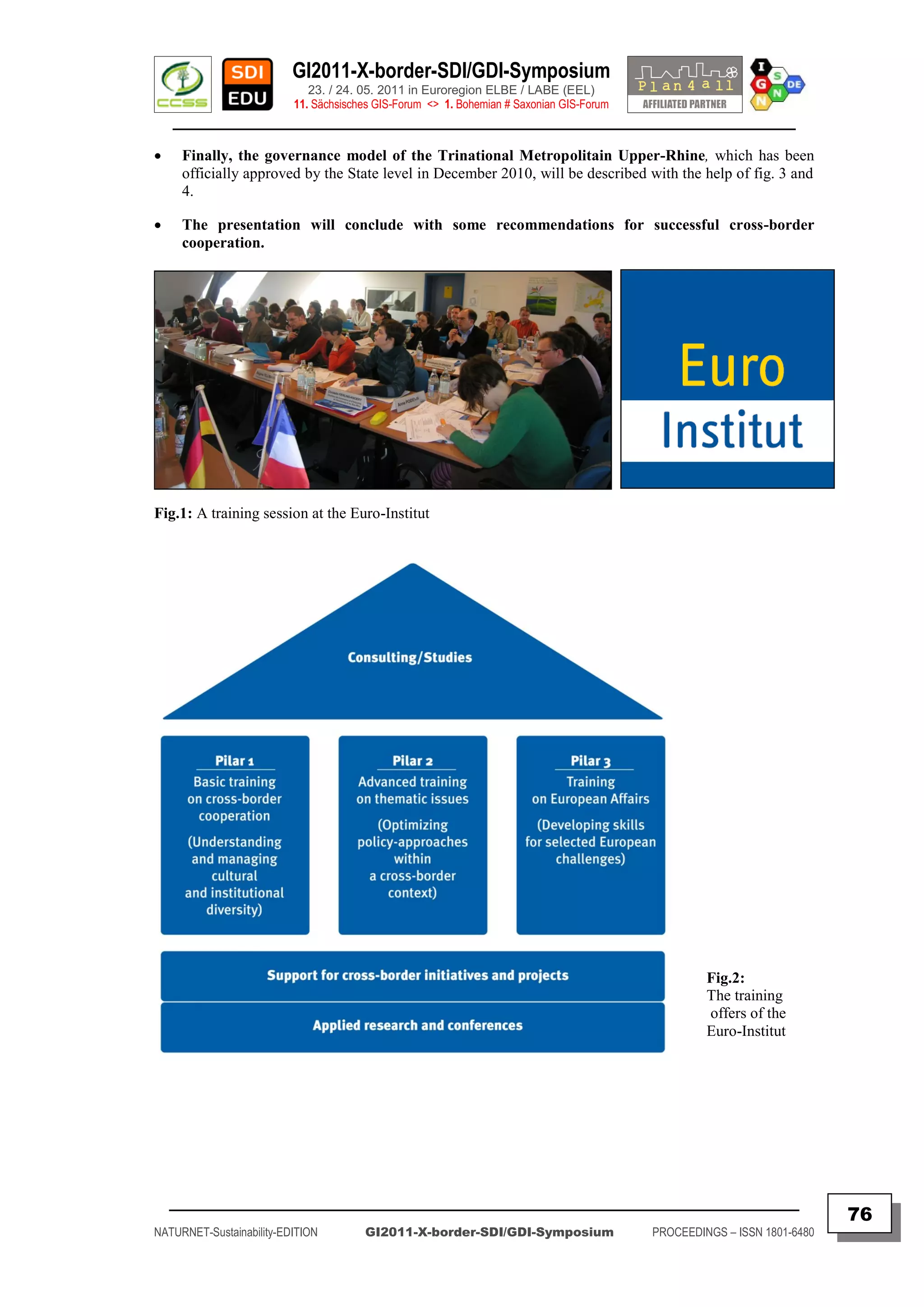
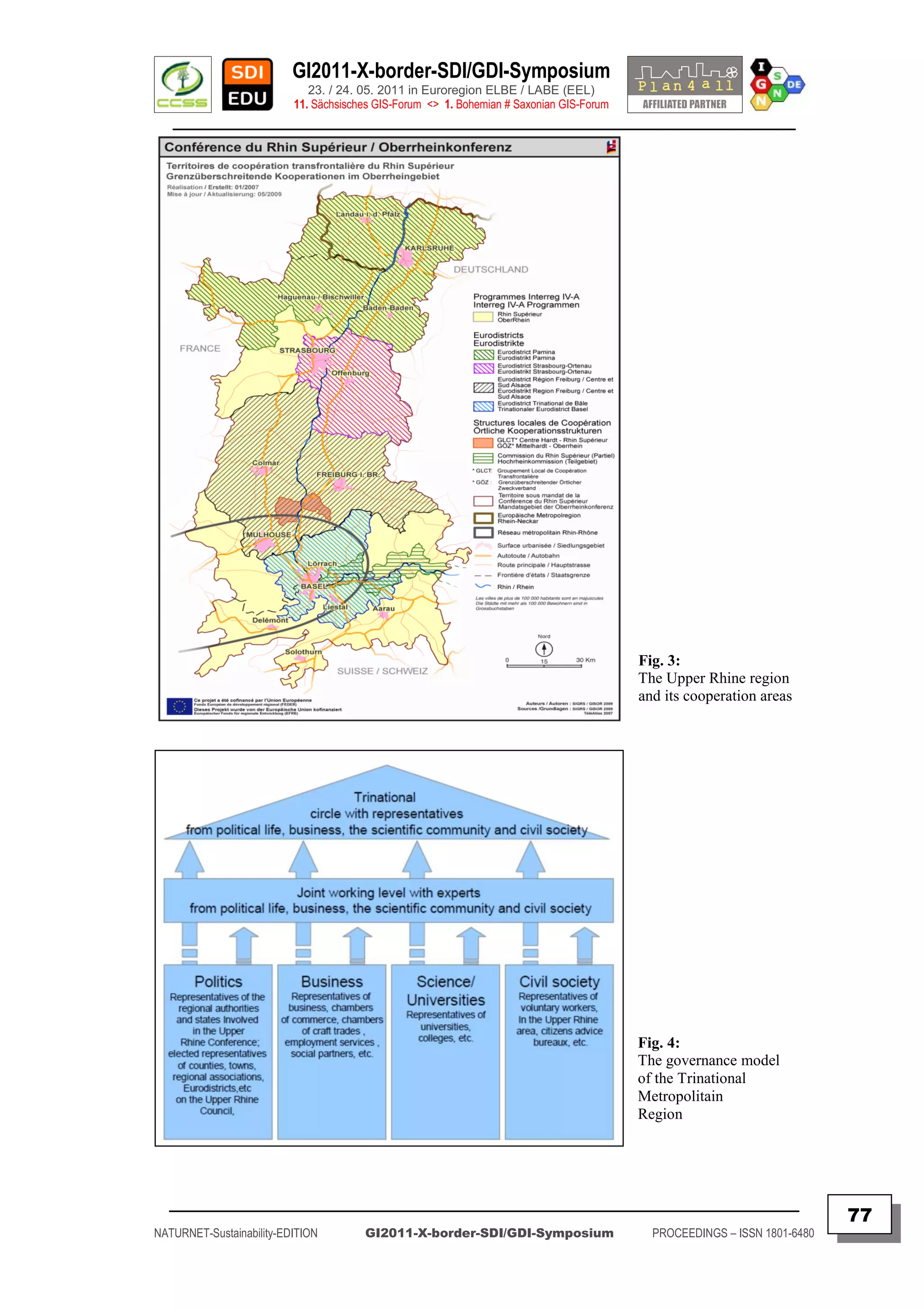
![GI2011-X-border-SDI/GDI-Symposium
23. / 24. 05. 2011 in Euroregion ELBE / LABE (EEL)
11. Sächsisches GIS-Forum <> 1. Bohemian # Saxonian GIS-Forum
________________________________________________________________________________________
GEOPORTAL FOR EVERYBODY (G4E)
OPENSOURCE TOOLS SUPPORTING BORDER REGIONS
Premysl VOHNOUT
Czech Center for Sciences & Society (CCSS, Praha – CZ)
Keywords: INSPIRE, geoportal, OGC standards, metadata
Abstract:
Geoportal is always an application which is developed for one scenario using
mostly proprietary, but closed source technology. These technologies are always very
expensive because of licensing and lot of implementation work needed to be done.
Geoportal4everybody conception is trying to solve the problems using mainly
open source technology and providing a package of connected applications. These
applications provides all requirements defined by INSPIRE.
Geoportal4everybody is an open and standardized interface that enables
search, portrayal, evaluation, sharing, analyse and reuse of spatial and non-spatial
data. G4E-Portal is a solution based on interoperable standards (OGC, W3C, OASIS,
and ISO). G4E is interconnected to other resources through the Internet.
Features:
Independent components
Composition according to user requirements
Based on SOA
Possibility to integrate with other resources
Maximum emphasis on
Open Source
Open Standards
Extension to non-GIS community
Open Search
Administration of other (non-spatial) data sources
Components:
MicKA
Catalogue client (CSW 2.0.2)
Map Viewer
SimpleCMS
Spatial and non-spatial data management
Author
Dipl.Ing. Premysl Vohnout
Contact
Czech centre for Science and Society
Radlicka 28, Prague
Email: [ vohnout@ccss.cz ]
_________________________________________________________________________________________
78
NATURNET-Sustainability-EDITION GI2011-X-border-SDI/GDI-Symposium PROCEEDINGS – ISSN 1801-6480](https://image.slidesharecdn.com/gi2011proceedingsv5final-110705072117-phpapp02/75/GI2011-proceedings-v5-final-78-2048.jpg)
![GI2011-X-border-SDI/GDI-Symposium
23. / 24. 05. 2011 in Euroregion ELBE / LABE (EEL)
11. Sächsisches GIS-Forum <> 1. Bohemian # Saxonian GIS-Forum
________________________________________________________________________________________
POSITION PAPER ON THE DIGITAL AGENDA FOR EUROPE
PRESS INFORMATION
EUROPEAN UMBRELLA ORGANISATION FOR GEOGRAPHIC INFORMATION
EUROGI has submitted its contribution and POSITION PAPER to the EC on-line Public Consultation on electronic
identification, authentication and signatures - ICT for Government and Public Services.
Leuven, 15th April 2011
EUROGI is the umbrella organisation for the European geographic information (GI)
community. Among its member organisations are the GI organisations representing the
majority of the EU member states, as well as national GI organisations from non-EU
member European countries and major companies in the GI sector. EUROGI thus
represents a community of some 6500 institutional, organisational and individual
stakeholders in this field.
As the EUROGI President I would like to use the Commission‟s call for a public
consultation on electronic identification, authentication and signatures, to put forward a
brief position paper on the Digital Agenda for Europe in general.
The Agenda states [COM(2010)245] that the ICT sector is responsible for 5% of
European GDP, corresponding to a market value of about €660b annually. This market
is nurtured by the electronic information content, of which more than half is GI. This
proportion is confirmed by many national studies in European countries. On the
European level, the latest study, dating unfortunately from the year 2000, provides
indicative support for this by stating that out of public sector information worth €68b,
about €36b is geographical in nature [Pira intl. ltd.: “Commercial exploitation of
Europe’s public sector information”, study for the European Commission, 2000].
The high proportion of digital content in the public sector which is GI will almost
certainly reflect the high proportion of GI more generally in digital content. Not only is
GI already firmly established in areas like satellite navigation, emergency response,
environmental policy making, climate change monitoring and many others, but
increasingly it is becoming embedded in social media (eg Twitter), a rapidly growing
field. In the future the amount and proportion of GI will no doubt sore to new levels as
the number of instruments which record and transmit location information increases
rapidly, possibly entering into the billions (RFIDs, mobile phones etc). In fact a veritable
explosion of digital content which has a GI component is taking place and will continue
to take place.
It is therefore incomprehensible that a Digital Agenda for Europe has been
written with no single mention of one of the most ubiquitous and important
current and future forms of digital content, namely GI. The more so since the
overall context of its emergence is geographic.
Council Conclusions of the 2999th Competitiveness Council of 1 March 2010, that
commission the Digital Agenda, list one line below in the same article 9
“transforming Europe into an eco-efficient economy while baring in mind both
the benefits and the costs of this transition” as another priority. It is clear that for
most decisions in this process GI is indispensible.
_________________________________________________________________________________________
80
NATURNET-Sustainability-EDITION GI2011-X-border-SDI/GDI-Symposium PROCEEDINGS – ISSN 1801-6480](https://image.slidesharecdn.com/gi2011proceedingsv5final-110705072117-phpapp02/75/GI2011-proceedings-v5-final-80-2048.jpg)
![GI2011-X-border-SDI/GDI-Symposium
23. / 24. 05. 2011 in Euroregion ELBE / LABE (EEL)
11. Sächsisches GIS-Forum <> 1. Bohemian # Saxonian GIS-Forum
________________________________________________________________________________________
Furthermore, the Europe 2020 strategy, which is behind the Council conclusion, has
sustainable growth as one of three priorities. Together with the Digital Agenda is
GMES, having a true geo-information remit, part of another of the seven flagship
initiatives of Europe 2020. The Digital Agenda makes however no cross-reference
to it either.
The absence of any mention of the spatially-referenced part of ICT impairs the
consistency of the Agenda because application fields that it alludes to (climate change,
cultural heritage, eGovernment and eEnvironment, including cross-border services,
efficient transport and mobility) offer suitable contexts where references to GI could
well have been placed. Even the actions of the present consultation (identification and
authentication) which at face value would seem to have little GI content, have an
intrinsic spatial reference because every individual has a physical home or work
address.
We believe that without adequate reference to GI in the Digital Agenda there will
be significant missed opportunities to grow the European GI business sector and
create high value adding jobs. The benefits of full recognition and inclusion of GI
into a Digital Agenda will not be confined to the economic sphere but will have
benefits in such diverse areas as promotion of democracy, improvement of everyday
convenience and welfare of our citizens, efficient and effective governance, and for the
protection and enhancement of the environment.
Thus I would like to urge the European Commission in the interests of sustainable
economic, social, governance and environmental development, to give due
consideration to GI and the important role it can play, in every revision of the text as
well as in related and subordinate documents.
Should there be a need to discuss the issues raised in this letter I and certain of our
members would be most willing to meet with Commission staff directly.
Bruce McCormack
EUROGI President
SOURCE: EUROGI (re-formatted by IGN / FH)
[ http://www.eurogi.org/POOLED/articles/bf_newsart/view.asp?Q=bf_newsart_322849 ]
References
[ http://www.eurogi.org/default.asp ]
EUROGI - European Umbrella Organisation for Geographic Information
p/a GEO-Instituut Campus Arenberg, Celestijnenlaan 200 E, bus 2411,
3001 Leuven, BELGIUM
Contact
EUROGI office: Catharina Bamps
Email: [ catharina.bamps@eurogi.org ]
Office: +32-16-322.946
_________________________________________________________________________________________
81
NATURNET-Sustainability-EDITION GI2011-X-border-SDI/GDI-Symposium PROCEEDINGS – ISSN 1801-6480](https://image.slidesharecdn.com/gi2011proceedingsv5final-110705072117-phpapp02/75/GI2011-proceedings-v5-final-81-2048.jpg)
![GI2011-X-border-SDI/GDI-Symposium
23. / 24. 05. 2011 in Euroregion ELBE / LABE (EEL)
11. Sächsisches GIS-Forum <> 1. Bohemian # Saxonian GIS-Forum
________________________________________________________________________________________
NIEDERLANDE UND NRW WOLLEN KOOPERATION
BEIM KATASTROPHENSCHUTZ AUSBAUEN
BESSERE HILFE FÜR DIE MENSCHEN ÜBER DIE LANDESGRENZEN HINWEG
( BETTER HELP FOR PEOPLE ACROSS THE STATE BORDER )
PRESSEMITTEILUNG
MINISTERIUM FÜR INNERES UND KOMMUNALES
Presseerklärung der Minister Opstelten (NL) und Jäger (NRW)
ABSTRACT
Keywords: Civil protection, Crisis prevention, Cross-border, Emergency, Euroregion, Ministry of
Interior, Netherland, Nord-Rhine-Westfalia, Risk protection, Security.
Contents:
Nordrhein-Westfalen und die Niederlande wollen bei der Bewältigung von Katastrophen
verstärkt zusammenarbeiten. Grenzüberschreitende regionale Kooperationen sowie kurze
Kommunikations- und Anforderungswege für den Krisenfall sollen verbindlich festgelegt werden.
"Unglücksfälle machen vor Landesgrenzen nicht Halt. Deshalb müssen wir uns gegenseitig effizient und
effektiv helfen, wenn der andere einen braucht", sagte Innenminister Ralf Jäger heute (23.03.) auf
einem Fachkongress in Aachen an dem der niederländischen Minister für Sicherheit und Justiz, Ivo
Opstelten, teilnahm.
Nach Ansicht der beiden Minister muss der Katastrophenschutz über die Landesgrenzen
hinweg funktionieren und zielgerichtet vernetzt werden. "Wenn unsere eigenen Ressourcen nicht reichen,
wird uns der Nachbar unterstützen - und umgekehrt", erklärte Jäger. "Das ist ein Garant für mehr
Sicherheit der Menschen über die Grenzen hinweg", betonte Minister Opstelten.
Auch die gemeinsame Vorbeugungsarbeit soll intensiviert werden. "Je mehr wir über
drohende Gefahren wissen, desto zielgerichteter können wir uns auf sie vorbereiten. Dazu gehört, dass
wir uns gegenseitig über die bestehenden Risiken und Gefahrenquellen informieren, diese Daten
bewerten und gemeinsame Abwehrstrategien entwickeln", erläuterte Jäger.
Der Kongress zum Thema grenzüberschreitender Katastrophenschutz bildet den
Schlussstein einer Veranstaltungsreihe, die im vergangenen Jahr begonnen hat. Bereits die
Feuerwerkskatastrophe in Enschede hatte deutlich gemacht, wie wichtig die grenzüberschreitende
Gefahrenabwehr ist. Damals waren Großeinheiten aus Deutschland spontan zur Hilfe geeilt.
Die Zusammenarbeit auf regionaler Ebene ist seitdem erweitert und intensiviert worden. Die
gegenseitige Unterstützung der Feuerwehren und Rettungsdienste auf örtlicher Ebene über die
gemeinsame Grenze hinweg gehört zum gelebten Alltag. Jäger: "Wer am schnellsten am Einsatzort ist,
hilft. Die Grenze spielt dabei schon heute keine Rolle. Und das hat sich bewährt."
Reference
Date: Wed, 23 Mar 2011 12:48:37 +0100
To: 320052219146-0001@t-online.de
Ministerium für Inneres und Kommunales
des Landes Nordrhein-Westfalen
Presse- und Öffentlichkeitsarbeit
40190 Düsseldorf
Contact
Email: [ abo@im.nrw.de ]
[ http://www.im.nrw.de/hom/15.htm ]
_________________________________________________________________________________________
82
NATURNET-Sustainability-EDITION GI2011-X-border-SDI/GDI-Symposium PROCEEDINGS – ISSN 1801-6480](https://image.slidesharecdn.com/gi2011proceedingsv5final-110705072117-phpapp02/75/GI2011-proceedings-v5-final-82-2048.jpg)
![GI2011-X-border-SDI/GDI-Symposium
23. / 24. 05. 2011 in Euroregion ELBE / LABE (EEL)
11. Sächsisches GIS-Forum <> 1. Bohemian # Saxonian GIS-Forum
________________________________________________________________________________________
POLAND IMPLEMENTS ESRI-BASED INSPIRE
SOLUTION
27 April 2011, 3:23pm
PRESS INFORMATION
Redlands, California - April 27, 2011 - The Head Office of Geodesy and Cartography
in Poland (GUGiK) is implementing an Esri-based solution to support compliance with the
European Union's Infrastructure for Spatial Information in Europe (INSPIRE) Directive. The
directive sets out a framework and timetable for implementing a pan-European spatial data
infrastructure (SDI) to address multinational and multi-agency issues. GUGiK is the central state
administration unit responsible for national policy related to geodesy and cartography.
ESRI's ArcGIS technology will be used to create GUGiK's GeoPortal2, a project
designed to improve access to government datasets and provide mapping and survey services
to other government agencies, citizens, and businesses.
GeoPortal2 includes ESRI's ArcGIS for INSPIRE product as well as software from Esri
business partner con terra GmbH. The project is being implemented by ESRI distributor ESRI
Polska sp. z o.o.; ESRI partner GISPartner; and the largest IT company in the country, Asseco
Poland SA.
GeoPortal2 is scheduled to be completed in November 2012 and will include:
Geographic names and addresses throughout Poland
Integrated and unified distribution of spatial data services defined by the INSPIRE Directive
Streamlined and improved data maintenance
Digital archive of spatial data for the central registry of data
Uniform maintenance on all orders of data products and services
More accurate monitoring of distributed resources
“ESRI Polska is excited by this opportunity and fully committed to working with GUGiK
to implement this strategic project successfully," says Lech Nowogrodzki, president, ESRI
Polska. "We look forward to making a real difference to the development of Poland's, and
Europe's, SDI."
Passed by the member states of the European Union and the European Parliament,
INSPIRE's goal is to tie European geospatial information producers and users together into a
single community to improve decision making and operations for a productive and sustainable
Europe.
For more information about ArcGIS for INSPIRE, visit the link below
SOURCE: Geo: International
[ http://www.geoconnexion.com/geo_news_article/Poland-Implements-Esri-Based-INSPIRE-Solution/10689 ]
References
[ http://media.netpr.pl/PressOffice/PressRelease.184361.po?print_version=true ]
[ http://www.directionsmag.com/pressreleases/poland-implements-esri-based-inspire-solution/176270 ]
[ http://www.wallstreet-online.de/nachricht/3141273-poland-implements-esri-based-inspire-solution ]
Contact
Email: [ mailto:inspire@esri.com ]
[ http://www.esri.com/software/arcgis/arcgis-for-inspire/index.html ]
_________________________________________________________________________________________
83
NATURNET-Sustainability-EDITION GI2011-X-border-SDI/GDI-Symposium PROCEEDINGS – ISSN 1801-6480](https://image.slidesharecdn.com/gi2011proceedingsv5final-110705072117-phpapp02/75/GI2011-proceedings-v5-final-83-2048.jpg)
![GI2011-X-border-SDI/GDI-Symposium
23. / 24. 05. 2011 in Euroregion ELBE / LABE (EEL)
11. Sächsisches GIS-Forum <> 1. Bohemian # Saxonian GIS-Forum
________________________________________________________________________________________
ePRACTICE.eu-WORKSHOP: ADDRESSING EVOLVING NEEDS
FOR CROSS-BORDER eGOVERNMENT SERVICES
Posting Date: 28 April 2011/ Last Edited Date: 3 May 2011 / Country Belgium
Submitted By [ ePractice Editorial Team ] (EUROPEAN DYNAMICS SA) | Belgium
PRESS INFORMATION
Category: eGovernment
Keywords: Efficiency & Effectiveness, Benchmarking | Services for Businesses |
Services for Citizens | Infrastructure | Interoperability | Legal Aspects | Policy |
Regional and Local
Tags: cross-border | egovernment | local national government | services
Submitted by: Eleni Galyfianaki (European Dynamics)
Location: Brussels (Belgium)
Date: 25 May 2011
Basic info
eGovernment (High Impact Services with Pan-European Scope; Interoperability;
Domain and topic:
Policy; Regional and Local; Other)
European Dynamics (Private (Contractor on behalf of Public Organisation)
Organiser:
Organisation)
Languages: English
Scope: Pan-European
Expected
70
participants:
Contact email: Eleni.Galyfianaki@eurodyn.com
Description
Cross-border access to public services of other European administrations by
citizens and businesses is one important step closer to a truly united Europe with
strengthened eGovernment services between public administrations in different
Member States.
This workshop is proposed to focus on the evolving needs of the European
Union towards a more efficient delivery of ICT-facilitated public services for citizens
and businesses across the EU. The target is to widen the scope of use of the electronic
means that public administrations have at their disposal outside the local, regional or
national level. A further aim is to facilitate mobility of businesses and citizens i.e. for
entrepreneurs to set up and run a business anywhere in Europe and allowing
individuals to study, work, reside, receive health care and retire anywhere in the
European Union.
_________________________________________________________________________________________
84
NATURNET-Sustainability-EDITION GI2011-X-border-SDI/GDI-Symposium PROCEEDINGS – ISSN 1801-6480](https://image.slidesharecdn.com/gi2011proceedingsv5final-110705072117-phpapp02/75/GI2011-proceedings-v5-final-84-2048.jpg)
![GI2011-X-border-SDI/GDI-Symposium
23. / 24. 05. 2011 in Euroregion ELBE / LABE (EEL)
11. Sächsisches GIS-Forum <> 1. Bohemian # Saxonian GIS-Forum
________________________________________________________________________________________
Submission of summaries/presentation slides:
To be considered for a speaker placement kindly submit a summary of one
page and four presentation slides of your intended presentation to events@eurodyn.com.
Regarding your summary, please download and complete the "Workshop form for
speakers" that may be found in the „Presentation and documents‟ section below.
Final presentations should not exceed 7 presentation slides and should be
concise and factual. The main point of your presentation is to briefly inform about the
project/initiative and encourage participation, questions and overall discussion.
Networking:
This workshop is all about networking. A few selected speakers will set the
scene with a 15 minute presentation and the rest of the programme will be dedicated to
roundtable discussions and networking purposes.
Contact:
Please, direct all queries to the above events@eurodyn.com. The event
coordinator will assist you promptly.
Agenda: TBA
Venue: How to get there
The workshop will take place in European Commission premises, BU25 / S1, in
Brussels, Belgium.
Address:Avenue de Beaulieu 25, Brussels, Belgium
SOURCE:
[ http://www.epractice.eu/files/Call for Participation cross-border SC11_v8 _FINAL.doc ]
References
[ http://www.epractice.eu/en/events/epractice-workshop-cross-border-services ]
[ Original news article - Digital Planning Application (in Dutch) ]
[ Digital Planning Application Leaflet (in Dutch) ]
Contact
• Email: [ mailto:inspire@esri.com ]
• [ http://www.esri.com/software/arcgis/arcgis-for-inspire/index.html ]
About epractice.eu
The European ePractice Newsletter is published under a contract with the European Commission. The
views expressed may not in any circumstances be regarded as stating an official position. Neither the
European Commission nor any person actingon its behalf is responsible for the use that might be made of
the information provided.
© European Union, 2011.
Reproduction is authorised, except for commercial purposes, provided the source is acknowledged
_________________________________________________________________________________________
86
NATURNET-Sustainability-EDITION GI2011-X-border-SDI/GDI-Symposium PROCEEDINGS – ISSN 1801-6480](https://image.slidesharecdn.com/gi2011proceedingsv5final-110705072117-phpapp02/75/GI2011-proceedings-v5-final-86-2048.jpg)
![GI2011-X-border-SDI/GDI-Symposium
23. / 24. 05. 2011 in Euroregion ELBE / LABE (EEL)
11. Sächsisches GIS-Forum <> 1. Bohemian # Saxonian GIS-Forum
________________________________________________________________________________________
DER LÄRM IN SACHSEN BEKOMMT EINE
LANDKARTE
PRESSEMITTEILUNG
SÄCHSISCHE ZEITUNG – ONLINE (DPA)
[ WWW.SZ-ONLINE.DE ]
Keywords: 2012, Cross-border, Directive, Emergency, EU, Kartierung, kommunaler
Lärmschutz, LfULG, Noise check, Noise mapping, Noise protection, Noise prevention, Saxony,
Schallschutz, Urban planning.
Contents:
Dresden (Donnerstag, 5. Mai 2011):
Der Lärm bekommt im Freistaat eine eigene Landkarte. Hupende Autos, holprige Straßen
und undichte Fenster fließen ebenso in die Berechnungen ein wie Schallschutzwände und die Zahl der
Nachbarn. Um den Lärm-Check drücken kann sich niemand:
Nach EU-Vorgaben müssen neben Dresden, Leipzig und Chemnitz 245 Gemeinden ihre
Geräuschkulisse bis 2012 in Karten darstellen. „Der Sinn dieser EU-Richtlinie ist es, sich einen
Überblick über die Belastung nach einheitlichen Kriterien zu verschaffen“, sagte Johannes Herhold
vom Landesamt für Umwelt, Landwirtschaft und Geologie. „Es gibt einen Farbschlüssel. Je blauer der
Fleck, desto größer der Lärm.“
Die Karten werden EU-weit nach denselben Kriterien erstellt. Im Freistaat übernimmt das
zuständige Landesamt den Großteil der Gemeinden. Lärmexperte Herhold rechnet für die Gemeinden mit
Kosten von bis zu 500 Euro pro angefangenem Kilometer.
Insgesamt werden rund 1650 Kilometer Strecke auf Lärm untersucht. Dresden, Leipzig und
Chemnitz noch nicht mitgezählt - die drei größten Städte im Freistaat untersuchen ihren Krach auf eigene
Faust. Den ersten Lärm-Check gab es bereits 2007. Mit einem Messgerät an der Autobahn stehe dabei
jedoch niemand, sagte Herhold. „Es wird ein Mittelwert über das ganze Jahr berechnet.“ Die Daten
kämen unter anderem von den Gemeinden, der Straßenbauverwaltung und von Vermessungsämtern.
Wer in einem besonders blauen Fleck wohnt, muss sich aber nicht mit einer Riesenpackung
Ohrstöpseln zufriedengeben. „Es dreht sich alles um die Bevölkerung“, sagte Herhold. Betroffene
Gemeinden sollen einen Plan erstellen, um künftig wieder mehr Ruhe zu haben. „Es gibt natürlich kein
Mittel, mit dem man das Problem auf einen Schlag loswird“, sagte der Lärmexperte.
Bessere Straßenbeläge, Geschwindigkeitsgrenzen oder Schallschutzfenster könnten jedoch
ein Anfang sein. Ob die Sachsen danach ruhiger schlafen, stellt sich spätestens in fünf Jahren heraus:
Dann wird neu berechnet. (dpa)
QUELLE: DPA (re-formatted by IGN/FH)
References
[ http://www.sz-online.de ]
[ http://www.sz-online.de/nachrichten/artikel.asp?id=2756338 ]
_________________________________________________________________________________________
87
NATURNET-Sustainability-EDITION GI2011-X-border-SDI/GDI-Symposium PROCEEDINGS – ISSN 1801-6480](https://image.slidesharecdn.com/gi2011proceedingsv5final-110705072117-phpapp02/75/GI2011-proceedings-v5-final-87-2048.jpg)
![GI2011-X-border-SDI/GDI-Symposium
23. / 24. 05. 2011 in Euroregion ELBE / LABE (EEL)
11. Sächsisches GIS-Forum <> 1. Bohemian # Saxonian GIS-Forum
________________________________________________________________________________________
IS OPEN LOCATION THE NEXT OPEN?
PRESS INFORMATION
V1 Magazine – Promoting Spatial Design for a Sustainable Tomorrow
Written by Matt Ball Friday, 06 May 2011 00:00
[ http://www.vector1media.com ]
There are a growing number of open movements that include open access, open
source software, open government, open standards, open data, open courseware, open
science, etc.
The Internet is the catalyst for these movements, with its ability to offer
transparency, a repository, and a means to create community connections. With all the
pushback on how both Apple and Google have stored personal location data, will open location
be the next movement ?
There are existing standards for interoperable linkages between location-based
service providers, but what we‟re talking about here is more of a user-centric movement as
backlash to how Apple and Google have treated user locations. Researchers at the New York
Times just launched [ Openpaths ] that is specifically aimed at sharing archived locations
from Apple devices for research purposes. This commendable effort goes a good way toward
gleaning insight on aggregated location data without exposing identity, but it‟s aimed
specifically at sharing of Apple‟s data before a patch is released to fix the problem. What
Openpaths has started might provide a jumping off point for a means to consistently archive
and analyze location outside of, and independent from, your cell phone carrier or smart phone
environment.
User Control
Along the lines of other open efforts, the open location movement should be less
about the commercial potential and more about possibility. At present we give away our location
very freely, seldom realizing its value or the repercussions on how we are profiled. Our locations
say a lot about us, and are being mined for all sorts of insight, but the catch at present is that we
have little control. The idea of pervasive and consistent personal tracking, but with full
control on when and how we share that information, has some interesting possibilities.
There is value to the insight into human behavior derived from our location. The
promise of location-based services have been around for more than ten years now, and an
interesting evolution in that span is that we used to fear the cell phone carriers, but it‟s now the
operating system providers and device manufacturers that are feared.
_________________________________________________________________________________________
88
NATURNET-Sustainability-EDITION GI2011-X-border-SDI/GDI-Symposium PROCEEDINGS – ISSN 1801-6480](https://image.slidesharecdn.com/gi2011proceedingsv5final-110705072117-phpapp02/75/GI2011-proceedings-v5-final-88-2048.jpg)
![GI2011-X-border-SDI/GDI-Symposium
23. / 24. 05. 2011 in Euroregion ELBE / LABE (EEL)
11. Sächsisches GIS-Forum <> 1. Bohemian # Saxonian GIS-Forum
________________________________________________________________________________________
Regardless of the power shift, there have always been issues of privacy concern
about who knows where I am and what I‟m doing, particularly when there is a recording of my
movements. Putting more transparency on who knows this information, and providing ironclad
opt-out capabilities should now be demanded.
Restrictive but Not Restricting
Setting restrictions on location information is a tough road now that we‟ve come to
expect development platforms with open sharing of location. While the days of unregulated
access to location may be over, the curtailing of „clandestine‟ tracking is perhaps as simple as
providing reports of what is known about movements, and providing a means for users to
explore their records. The element of transparency provides the needed trust that has been
lost, and the many benefits of enhanced social interaction and improved navigation are
likely all the payment that is needed.
There is a growing realization that we are our best sensors, and the use of people
for gathering metrics on a wide number of things via location-enabled handheld devices is
gaining ground. The recent [ Leafsnap ] application that provides a means to determine tree
type in exchange for the location where the tree was found is one example of simple
permission-based use of location that is point specific and that opens up a whole channel of
citizen science. Similar commercial exchanges of information regarding your interest in
particular goods and services along with your location provide a more transparent and equitable
exchange than a service provider who knows your profile and is tracking your whereabouts. A
move toward transaction-based location would provide a good degree of insight into location
interactions with a more manageable data stream, and a feeling that trust has been restored.
Owning the Insight
A good deal of the outrage about „locationgate‟ has to do with insight that people
have about us that we might not realize ourselves. Unleashing control of our interactions,
without having access to this information, feels that we‟re giving control of our lives to outside
entities that may even be unknown to us. We should be the owners of this insight or at least
privy to the details that others know as well as the repercussions.
Parallels on control of outcome can be drawn to our personal credit score. We‟re
aware on a transaction or monthly basis of how and where we spend our money and extend our
credit, even if we might lose sight of the big picture of our debt. Similarly, if we‟re to be tracked
and profiled based on our interactions, we should at a minimum know what conclusions
others are drawing from this information. Ideally, we‟ll also be able to close off and erase those
records against those we don‟t trust.
The issue of transparent location and tracking is one of fundamental freedom that is
fraught with past transgressions of power and control. An open location exchange, with a
focus on insight rather than monetary gains, would provide a focus on the promise of technology
rather than the leverage of closed devices. If we’re to make the most of this technology,
then the control of location must rest solely in the hands of the individual if society and
commerce are to benefit.
SOURCE (format edited by IGN / FH):
[ http://www.vector1media.com/dialog/perspectives/20122-is-open-location-sharing-the-next-open.html ]
_________________________________________________________________________________________
89
NATURNET-Sustainability-EDITION GI2011-X-border-SDI/GDI-Symposium PROCEEDINGS – ISSN 1801-6480](https://image.slidesharecdn.com/gi2011proceedingsv5final-110705072117-phpapp02/75/GI2011-proceedings-v5-final-89-2048.jpg)
![GI2011-X-border-SDI/GDI-Symposium
23. / 24. 05. 2011 in Euroregion ELBE / LABE (EEL)
11. Sächsisches GIS-Forum <> 1. Bohemian # Saxonian GIS-Forum
________________________________________________________________________________________
eSax – E-GOVERNMENT – AKTUELL
INTERNETDIENSTE ZUR BEREITSTELLUNG
SÄCHSISCHER GEODATEN
PRESS INFORMATION
Subject: [ eSax ] Newsletter des sächsischen E-Government
Date: Tue, 10 May 2011 10:37:34 +0200
From: eSax - E-Government Aktuell [ esax@newsletter.sachsen.de ]
Reply-To: [ esax-admin@newsletter.sachsen.de ] ; [ esax@newsletter.sachsen.de ]
To: [ esax@newsletter.sachsen.de ]
09.05.2011 - Erster sächsischer Geodienst für INSPIRE bereitgestellt
INSPIRE (Infrastructure for Spatial Information in the European Community) ist eine
Initiative der Europäischen Kommission zum Aufbau der europäischen Geodateninfrastruktur. Im
Rahmen dieser Initiative sind alle EU-Mitgliedstaaten verpflichtet, für verschiedene Themen
digitale Daten mit geografischem Bezug (Geodaten) über das Internet bereitzustellen.
Der nächste Meilenstein beim Aufbau von INSPIRE ist der 9. Mai 2011. Ab diesem
Zeitpunkt müssen die ersten Geodaten über so genannte Darstellungsdienste in einer
Anfangsbetriebsfähigkeit im Internet verfügbar sein.
Von dieser Verpflichtung sind neben Behörden des Freistaates Sachsen auch die
Landkreise und Kreisfreien Städte sowie teilweise auch weitere Gemeinden im Freistaat Sachsen
betroffen. Näheres kann im Internet unter:
[ http://www.gdi.sachsen.de ] oder [ http://inspire.jrc.ec.europa.eu ] in
Erfahrung gebracht werden.
Ansprechpartner für die Umsetzung von INSPIRE im Freistaat Sachsen:
• Staatsbetrieb Geobasisinformation und Vermessung Sachsen
• Referat Koordinierung Geodateninfrastruktur
• Tel. : +49-351 8283 4520
• Mailto: [ Koordinierungsstelle.GDI@geosn.sachsen.de ]
Aufgrund der europarechtlichen Verpflichtung hat der Staatsbetrieb
Geobasisinformation und Vermessung Sachsen ab dem 9. Mai 2011 die Anfangs-
Betriebsfähigkeit von Darstellungsdiensten zu folgenden INSPIRE-Datenthemen hergestellt:
• Flurstücke (Katasterparzellen)
• Adressen
Für Interessierte sind beide Internetdienste im Geoportal « Sachsenatlas » unter
[ http://www.atlas.sachsen.de ] abrufbar.
QUELLE : [ eSax ] Newsletter des sächsischen E-Government © Sächsische Staatskanzlei
_________________________________________________________________________________________
90
NATURNET-Sustainability-EDITION GI2011-X-border-SDI/GDI-Symposium PROCEEDINGS – ISSN 1801-6480](https://image.slidesharecdn.com/gi2011proceedingsv5final-110705072117-phpapp02/75/GI2011-proceedings-v5-final-90-2048.jpg)
![GI2011-X-border-SDI/GDI-Symposium
23. / 24. 05. 2011 in Euroregion ELBE / LABE (EEL)
11. Sächsisches GIS-Forum <> 1. Bohemian # Saxonian GIS-Forum
________________________________________________________________________________________
9. Bayern: E-Government-Loewe gefunden
Die Preise im Rahmen des Wettbewerbs Bayerischer E-Government-Loewe gehen in diesem
Jahr an die Oberste Baubehoerde fuer ihre Vergabeplattform, das Landratsamt Muehldorf fuer
die Loesung Fuehrerschein Online sowie das Umweltministerium fuer den Energie-Atlas
Bayern. http://www.kommune21.de/meldung_11973
Termine mit ausfuehrlichen Informationen finden Sie unter http://www.kommune21.de/termine
11.-25. Mai 2011, verschiedene Orte: Hausmesse „Forum 2011“
12. Mai 2011, Osnabrueck: Integriertes E-Government in Niedersachsen
17.-18. Mai 2011, Dresden: Intergraph-Forum
18. Mai 2011, Darmstadt: GDI im kommunalen Umfeld. Welchen Nutzen kann ich daraus
ziehen?
23.-24. Mai 2011, Bad Schandau / Decin: 11. Sächsisches GIS-Forum
24.-26. Mai 2011, Unterschleissheim: ESRI. Die deutschsprachige GIS-Konferenz
25.-26. Mai 2011, Nuernberg: e_procure & supply
26. Mai 2011, Koblenz: 5. egovday
27.-28. Mai 2011, Muelheim an der Ruhr: Kommune gemeinsam gestalten. Beteiligungs- und
Kooperationsprozesse zwischen Buergern, Wirtschaft und Kommune initiieren und realisieren
6.-7. Juni 2011, Berlin: DuD 2011. 13. Konferenz zu Datenschutz und Datensicherheit
References
„news@kommune21.de“ ist ein kostenloser Newsletter
Copyright: Alle Beitraege im Newsletter news@kommune21.de sind urheberrechtlich geschuetzt. Sie
wurden mit Sorgfalt recherchiert und zusammengestellt. Eine Haftung fuer fehlerhafte oder unrichtige Informationen
wird ausgeschlossen.
Abonnement: Schreiben Sie uns einfach eine e-Mail an mailto: mit Ihrer e-Mail-Adresse und dem Betreff
'subscribe' (abonnieren) bzw. 'unsubscribe' (abbestellen).
Contact
Email: [ news@kommune21.de ]
K21 media AG
Olgastrasse 8
72074 Tübingen
Tel. 07071.56513-0
Fax. 07071.56513-29
Internet: [ http://www.kommune21.de ]
ACKNOWLEDGEMENT
THE ORGANIZERS OF GI2011-X-BORDER-SDI/GDI-SYMPOSIUM ARE ACKNOWLEDGING THE SUPPORT GIVEN
BY PUBLISHING HOUSE OF K21 MEDIA AG - TÜBINGEN
PRESENTING TWO ISSUES OF JOURNAL MOVE – MODERNE VERWALTUNG / MODERN ADMINISTRATION
TO THE PARTICIPANTS OF THE GI2011-SYMPOSIUM !
IGN E.V.
_________________________________________________________________________________________
93
NATURNET-Sustainability-EDITION GI2011-X-border-SDI/GDI-Symposium PROCEEDINGS – ISSN 1801-6480](https://image.slidesharecdn.com/gi2011proceedingsv5final-110705072117-phpapp02/75/GI2011-proceedings-v5-final-93-2048.jpg)
![GI2011-X-border-SDI/GDI-Symposium
23. / 24. 05. 2011 in Euroregion ELBE / LABE (EEL)
11. Sächsisches GIS-Forum <> 1. Bohemian # Saxonian GIS-Forum
________________________________________________________________________________________
Programme:
(La traduction simultanée de l'intégralité du séminaire est assurée par deux traducteurs professionnels)
Ouverture du séminaire par M. Pierre-Etienne BISCH, Préfet de Région et Président de
la CRS, et M. Charles BUTTNER, Président du Conseil Général du Haut-Rhin
Le rôle des SIG et les enjeux de la directive Inspire en Europe :
Intervention d'un représentant de la Commission Européenne
Echange avec la salle
Présentation du SIGRS: concepts, enjeux et exemples concrets:
Intervention des cellules SIG et coordination du SIGRS
Echange avec la salle – Conférence de Presse pour les représentants politiques
Retours d‟expériences par trois utilisateurs du SIGRS:
Discussion entre experts allemand, français et suisse
Déjeuner – Buffet (offert par le SIGRS)
La contribution du SIGRS au développement du Rhin Supérieur:
Présentations du Président du groupe de travail Aménagement de la Conférence du
Rhin Supérieur et d‟un représentant du 12ème Congrès Tripartite
Echange avec la salle
Perspectives futures du SIGRS dans le contexte de la Région Métropolitaine
Trinationale (RMT) du Rhin Supérieur:
Intervention d‟un représentant de la RMT
Synthese - Clôture - Verre de l‟amitié
Flyer d'invitation:
[ http://sigrs-
gisor.org/Extranet/FileDownload.php?fichier=Invit_Einlad_05_2011.pdf ]
[ http://sigrs-gisor.org/CDIS2009/Presentations/P1_DE.pdf ]
Reference
Date: 13.05.2011
[ http://sigrs-gisor.org ]
Contact
Groupe d'Experts SIGRS Cellule Coordination Cellule SIG
Conseil Général du Haut-Rhin Conseil Général du Haut-Rhin Conseil Général du Haut-Rhin
100, avenue d'Alsace 100, avenue d'Alsace 100, avenue d'Alsace
BP 20351 - 68006 COLMAR BP 20351 - 68006 COLMAR BP 20351 - 68006 COLMAR
Cedex Cedex Cedex
Tel : 03.89.30.64.28 Tel : 03.89.30.64.28 Tel : 03.89.30.63.91
Fax: 03.89.21.64.53 Fax: 03.89.21.64.53 Fax: 03.89.21.64.53
Email: soulaimani(at)cg68.fr Email: soulaimani(at)cg68.fr Email: stern(at)cg68.fr
_________________________________________________________________________________________
95
NATURNET-Sustainability-EDITION GI2011-X-border-SDI/GDI-Symposium PROCEEDINGS – ISSN 1801-6480](https://image.slidesharecdn.com/gi2011proceedingsv5final-110705072117-phpapp02/75/GI2011-proceedings-v5-final-95-2048.jpg)
![GI2011-X-border-SDI/GDI-Symposium
23. / 24. 05. 2011 in Euroregion ELBE / LABE (EEL)
11. Sächsisches GIS-Forum <> 1. Bohemian # Saxonian GIS-Forum
________________________________________________________________________________________
INSPIRE-UMSETZUNG IN SACHSEN
POST – WORKSHOP – INFORMATION
der „gdi.initiative.sachsen“
vom 16.05.2011 zum
„1.Workshop der GDI Sachsen“
am 10. Mai 2011 im
Staatsministerium des Innern
Am 10. Mai 2011 trafen sich auf Einladung des Staatsministeriums des Innern
70 Teilnehmer zum 1. Workshop der GDI Sachsen in Dresden.
Schwerpunkte waren:
die Vorstellung des Entwurfes des Betriebsmodells der GDI Sachsen
und des Betriebskonzepts Geothemenmanagement,
Informationen zum Stand der INSPIRE-Umsetzung sowie die
Präsentation von Lösungsansätzen für die Aufbereitung von Geodaten.
Die Vertreter von staatlichen und kommunalen geodatenhaltenden Stellen
sowie wissenschaftlichen Einrichtungen wurden über die zum 9. Mai 2011
termingerecht hergestellte Anfangsbetriebsfähigkeit von INSPIRE-Darstellungsdiensten
für die Themen Flurstücke und Adressen informiert. Die in einer Livevorführung
gezeigte Einbindung dieser Dienste in Geoanwendungen nahmen die Teilnehmer mit
großem Interesse zur Kenntnis.
Ein aktueller Aufgabenschwerpunkt bei der Umsetzung der INSPIRE-
Richtlinie ist die Ermittlung der Geodaten der GDI Sachsen und der für deren
Bereitstellung verantwortlichen geodatenhaltenden Stellen. Auf Basis des in der
Veranstaltung vorgestellten Betriebskonzepts Geothemenmanagement ist bei dieser
Ermittlung ein weiteres zielgerichtetes Vorgehen mit den betroffenen
geodatenhaltenden Stellen erforderlich.
Die Ergebnisse des INSPIE-Monitorings 2010 veranschaulichen die
zunehmende Wahrnehmung der Aufgaben einer Vielzahl geodatenhaltender Stellen bei
der Erfassung und Bereitstellung von Metadaten entsprechend der INSPIRE-
Durchführungsbestimmung.
Die Veranstaltung zeigte, dass der Freistaat Sachsen für die Umsetzung der
INSPIRE-Richtlinie konzeptionell gut aufgestellt ist und konkrete Lösungsansätze zur
Erfüllung der Anforderungen der INSPIRE-Richtlinie erarbeitet wurden.
QUELLE © GeoSN – Staatsbetrieb Geobasisinformation und Vermessung Sachsen,
Referat 42 - Koordinierung Geodateninfrastruktur ( format-edited by IGN / FH ):
[ http://www.gdi.sachsen.de/inhalt/info/bericht/110516/110516.html ]
_________________________________________________________________________________________
96
NATURNET-Sustainability-EDITION GI2011-X-border-SDI/GDI-Symposium PROCEEDINGS – ISSN 1801-6480](https://image.slidesharecdn.com/gi2011proceedingsv5final-110705072117-phpapp02/75/GI2011-proceedings-v5-final-96-2048.jpg)
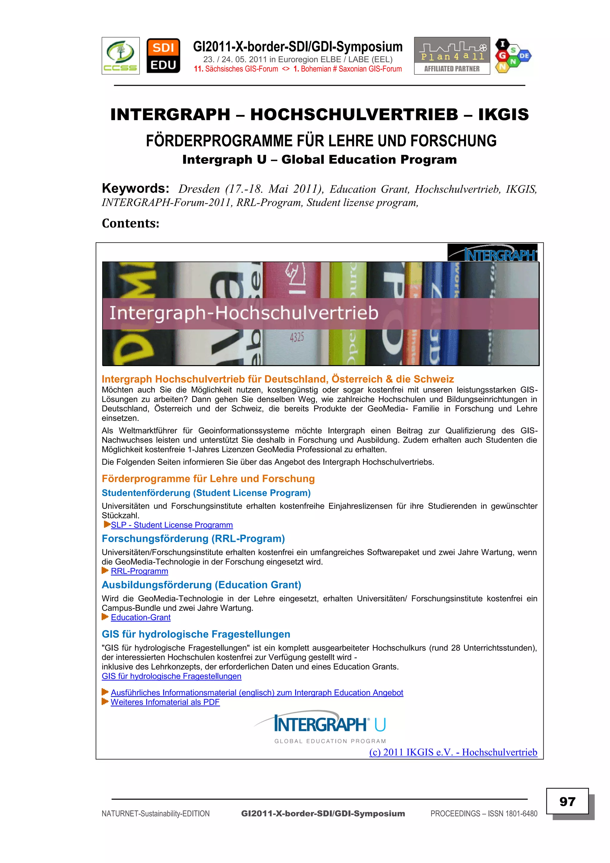
![GI2011-X-border-SDI/GDI-Symposium
23. / 24. 05. 2011 in Euroregion ELBE / LABE (EEL)
11. Sächsisches GIS-Forum <> 1. Bohemian # Saxonian GIS-Forum
________________________________________________________________________________________
AUFBAU DER GEODATENINFRASTRUKTUR
IM FREISTAAT SACHSEN
Staatsregierung verabschiedet den Bericht zum Aufbau der Geodateninfrastruktur
im Freistaat Sachsen für das Jahr 2010
PRESSEINFORMATION
SMI – Sächsisches Staatsministerium des Innern – Landesentwicklung | Infrastruktur – 17.05.2011
Von: medienservice@egov.sachsen.de / Datum: 17.05.2011 / 14:15
Betreff: [SMI] Aufbau der Geodateninfrastruktur im Freistaat Sachsen
Die Staatsregierung verabschiedete am 17. Mai 2011 den Bericht zum Aufbau der Geodateninfrastruktur im
Freistaat Sachsen (GDI Sachsen) für den Zeitraum 1. Januar 2010 bis 31. März 2011.
Die GDI Sachsen schafft die technischen und organisatorischen Voraussetzungen für eine kostensparende
und anforderungsgerechte Erschließung und Bereitstellung digitaler Geodaten unterschiedlicher Quellen und dient
damit der Befriedigung eines stark wachsenden Bedarfs an solchen Daten. Nicht zuletzt der große Erfolg von
kommerziellen Internetdiensten, die in Sekundenschnelle Karten mit Informationen für einen konkreten,
anlassbezogenen Bedarf (z. B. Sehenswürdigkeiten, Einkaufs- oder Übernachtungsmöglichkeiten) anzeigen,
verdeutlicht, dass Geodaten aus einer modernen Gesellschaft nicht mehr wegzudenken sind. Mit der GDI Sachsen
werden Strukturen aufgebaut, die – vergleichbar mit kommerziellen Internetdiensten – stets aktuelle amtliche
Geodaten von Behörden und Kommunen am Bildschirm anzeigen und für eine Weiterverarbeitung bereitstellen. Der
Freistaat Sachsen verknüpft dabei seine Verpflichtung zur Beteiligung am Aufbau einer Geodateninfrastruktur in der
Europäischen Gemeinschaft ( INSPIRE ) mit dem landespolitischen Ziel einer modernen, bürgernahen und
effizienten Verwaltung.
Der Bericht stellt den Stand der Umsetzung der Richtlinie 2007/2/EG des Europäischen Parlaments und des Rates
zur Schaffung einer Geodateninfrastruktur in der Europäischen Gemeinschaft (INSPIRE) im Freistaat Sachsen
dar. Er gibt Auskunft darüber, dass der Freistaat Sachsen mit dem am 5. Juni 2010 in Kraft getretenen Sächsischen
Geodateninfrastrukturgesetz seiner Verpflichtung zur Umsetzung der Richtlinie in Landesrecht nachgekommen ist.
Zur europäischen Geodateninfrastruktur trägt der Freistaat Sachsen aktuell bereits mit 191 amtlichen
Geodatensätzen und 57 Internetdiensten bei. Für Zwecke der Verwaltung und der Wirtschaft stehen insgesamt
jedoch schon ca. 4.000 Geodatensätze aus den verschiedensten Themengebieten in der GDI Sachsen bereit.
Der Bericht erläutert das Vorgehen zur gemeinsamen Bereitstellung von digitalen Geodaten über das
Internet durch die staatlichen und kommunalen Stellen sowie durch sächsische Wirtschaftsunternehmen. In diesem
Zusammenhang wird der Freistaat Sachsen das im Rahmen des E-Government betriebene Geoportal
„Sachsenatlas“ zu einer leistungsfähigen IT-Plattform weiterentwickeln, die voraussichtlich ab 2012 alle
Geodaten des Freistaates Sachsen mit höchster Qualität über moderne Internetdienste anbietet. Das Konzept für
den Aufbau dieser IT-Plattform wurde 2010 von staatlichen und kommunalen Experten mit Unterstützung der TU
Dresden und der HTW Dresden, entwickelt.
Mit dem Aufbau der IT-Plattform wollen der Freistaat Sachsen und die sächsischen Kommunen Folgendes
erreichen:
sächsische Daten für die Geodateninfrastruktur Deutschland und die Geodateninfrastruktur der
Europäischen Gemeinschaft effizient und wirtschaftlich bereitstellen,
die umfassende Bereitstellung und Nutzung von raumbezogenen Daten durch Verwaltung, Wirtschaft
und Bürger gewährleisten und
die Zahl der bei staatlichen und kommunalen Behörden eingesetzten IT-Verfahren durch die Nutzung
der zentralen IT-Plattform reduzieren.
Rückfragen an Pressesprecher Frank Wend: [ mailto:frank.wend@smi.sachsen.de ]
[ http://www.medienservice.sachsen.de ]
QUELLE © Medienservice Sachsen ( format-edited by IGN e.V. / FH )
_________________________________________________________________________________________
98
NATURNET-Sustainability-EDITION GI2011-X-border-SDI/GDI-Symposium PROCEEDINGS – ISSN 1801-6480](https://image.slidesharecdn.com/gi2011proceedingsv5final-110705072117-phpapp02/75/GI2011-proceedings-v5-final-98-2048.jpg)
![GI2011-X-border-SDI/GDI-Symposium
23. / 24. 05. 2011 in Euroregion ELBE / LABE (EEL)
11. Sächsisches GIS-Forum <> 1. Bohemian # Saxonian GIS-Forum
________________________________________________________________________________________
DER WIRTSCHAFTSRAUM
SACHSEN – BÖHMEN – NIEDERSCHLESIEN
POTENZIALE UND HERAUSFORDERUNGEN EINER
MAKROREGION IN MITTELEUROPA
POST-Event-PRESSEINFORMATION
MEDIENSERVICE SACHSEN
19.05.2011, 12:31 Uhr
70 Fachleute aus Sachsen, Polen und Tschechien befassten sich am gestrigen
Tag im Innenministerium mit dem Thema „Der Wirtschaftsraum Sachsen – Böhmen –
Niederschlesien: Potenziale und Herausforderungen einer Makroregion in
Mitteleuropa“.
Anlass dieser Veranstaltung war die seit dem 1. Mai 2011 eingesetzte
Arbeitnehmerfreizügigkeit, wodurch sich neue Herausforderungen für die Regionen
Sachsen. Böhmen und Niederschlesien ergeben. Alle Teilnehmer waren sich einig, dass
die Schaffung einer leistungsfähigen grenzüberschreitenden Wirtschaftskooperation in
einem gemeinsamen Wirtschaftsraum notwendig ist und letztlich allen drei Regionen
zugute kommen würde.
Unter anderem ging es darum, auf welche Weise grenzüberschreitende und
transnationale Projekte diesbezüglich wirksame Beiträge zur Fachkräftesicherung und
Qualifizierung leisten können. Einzelne positive Ansätze und Projekte zur Stärkung der
Innovationsleistung von Unternehmen, zur Vernetzung von Kernbranchen der Regionen
und zur Verknüpfung von Bildung und Ausbildung wurden im Rahmen dieser
Veranstaltung vorgestellt.
Die sächsische Landesplanung und Landesentwicklung hat dies früh
erkannt und in den letzten Jahren vielfältige Anstrengungen unternommen, die
transnationale und grenzüberschreitende Zusammenarbeit zu intensivieren und die
planerischen Voraussetzungen und Grundlagen hierfür zu verbessern.
Die verbesserte Anbindungsqualität und Erreichbarkeit von
Metropolräumen, Stadtregionen und Städten ist als wichtige Grundlage gerade auch für
die wirtschaftliche Entwicklung zu sehen. Insofern ist die Projektarbeit und enge
Zusammenarbeit über Grenzen hinweg ein wichtiger Baustein für die gesamte Region
und alternativlos im weltweiten Wettbewerb der Regionen.
Die Ergebnisse der verschiedenen EU-Projekte haben schließlich gezeigt,
dass die Potenziale, was die Einwohnerzahl, das hohe Bildungsniveau der Bevölkerung
und die Vielzahl der gut ausgebildeten Arbeitskräfte anbetrifft, für eine positive
Entwicklung des Wirtschaftsraumes Sachsen – Böhmen – Niederschlesien vorhanden
sind.
QUELLE © Medienservice Sachsen (format-edited by IGN e.V. / FH)
[ http://www.medienservice.sachsen.de/medien/news/159936 ]
[ http://www.medienservice.sachsen.de/medien/news/159936?page=2 ]
_________________________________________________________________________________________
99
NATURNET-Sustainability-EDITION GI2011-X-border-SDI/GDI-Symposium PROCEEDINGS – ISSN 1801-6480](https://image.slidesharecdn.com/gi2011proceedingsv5final-110705072117-phpapp02/75/GI2011-proceedings-v5-final-99-2048.jpg)
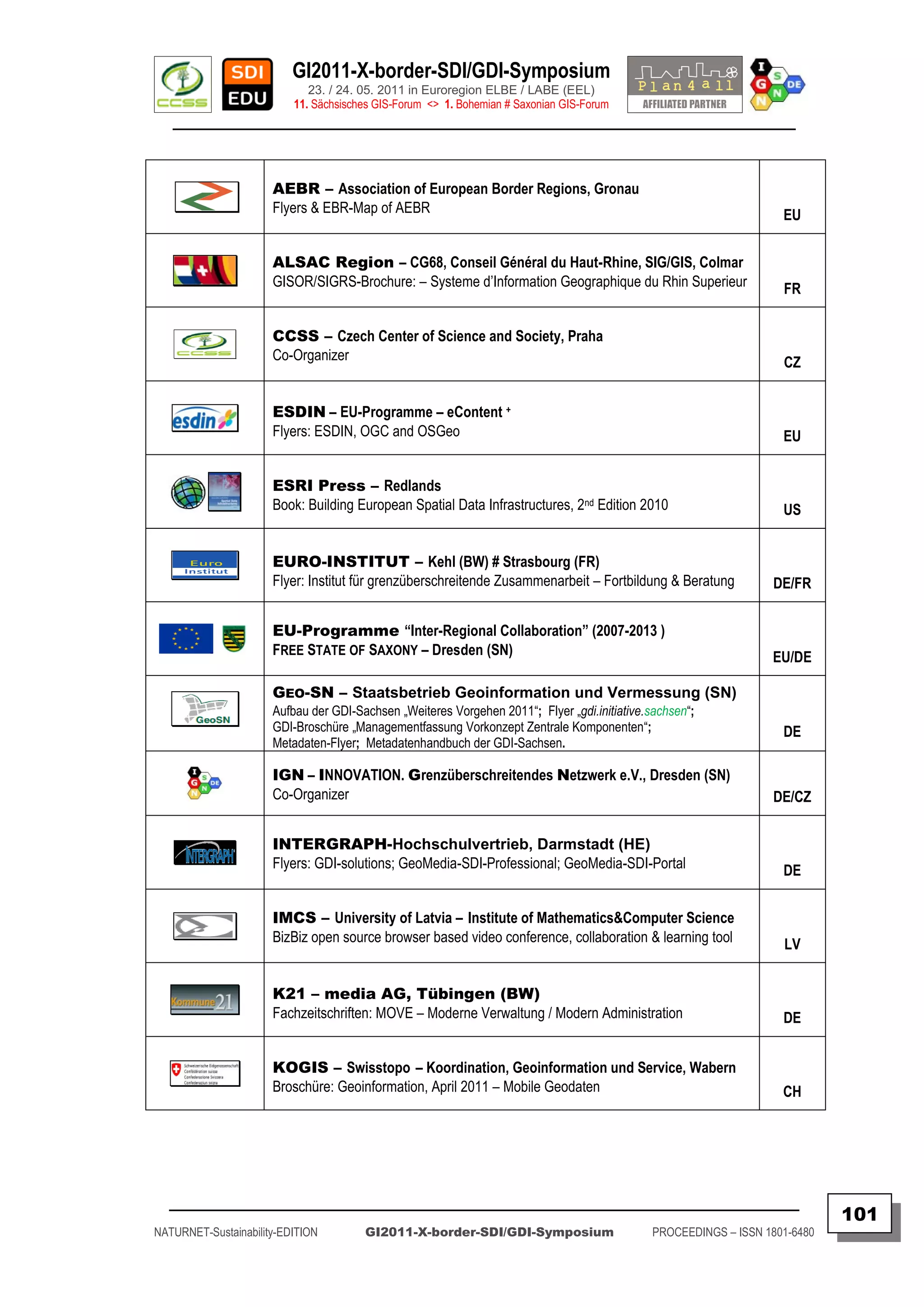
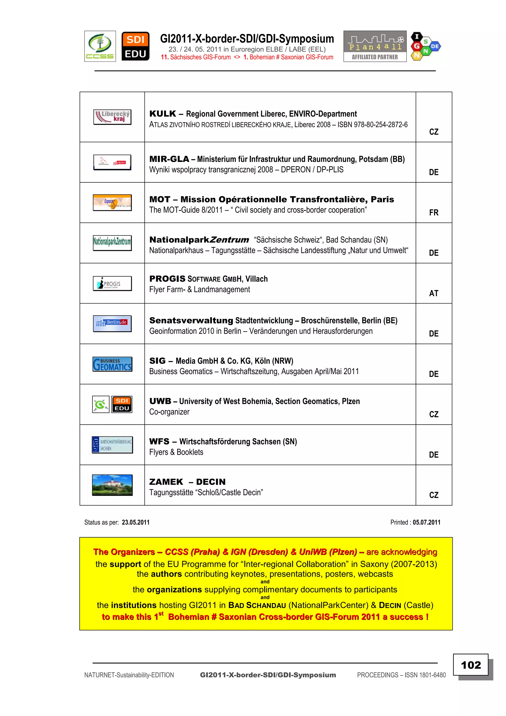
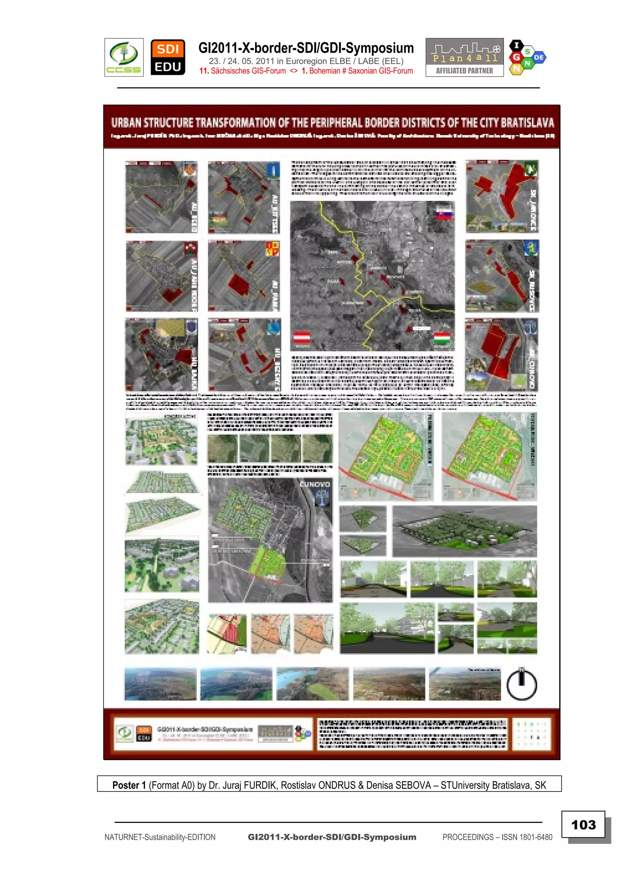
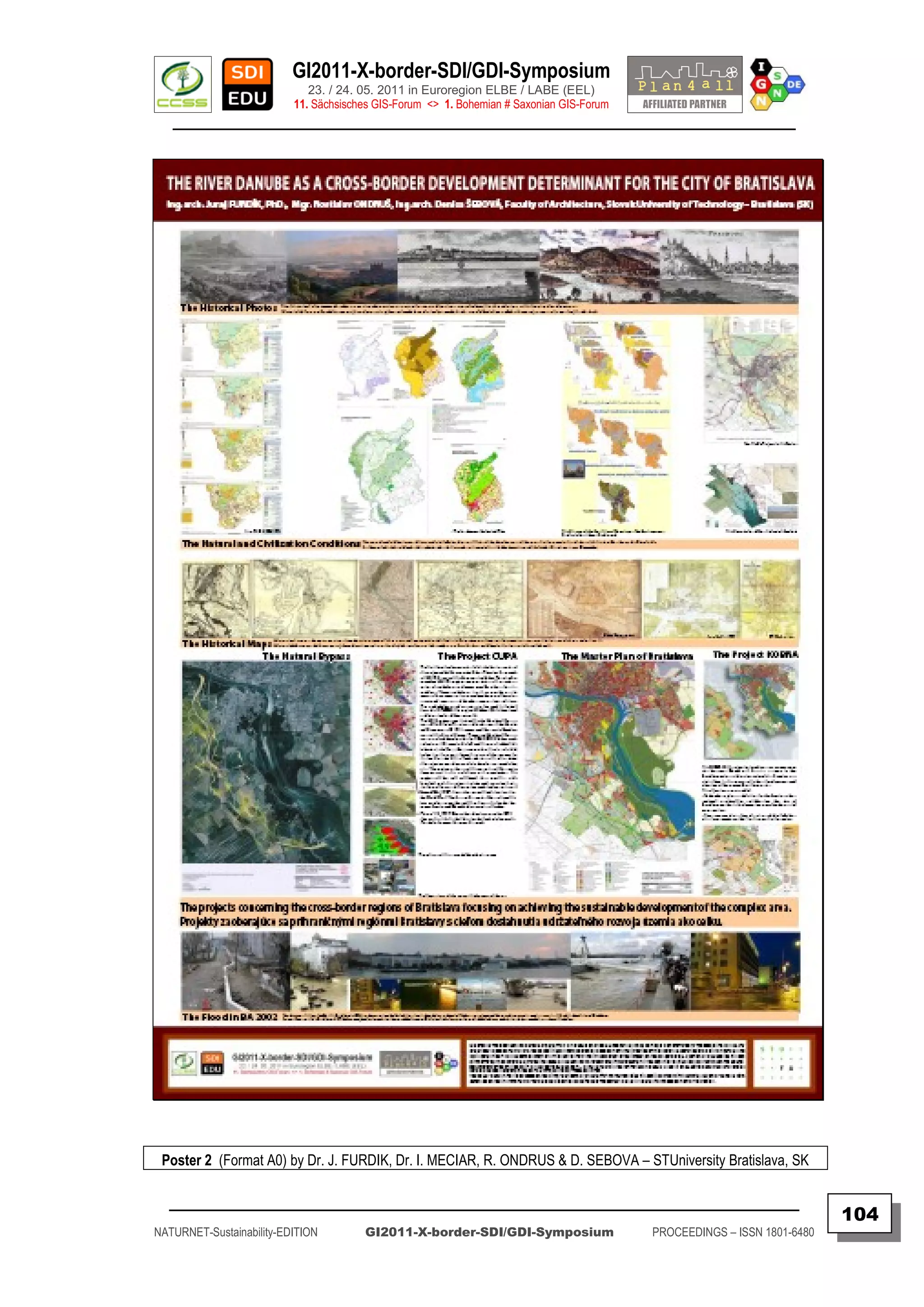
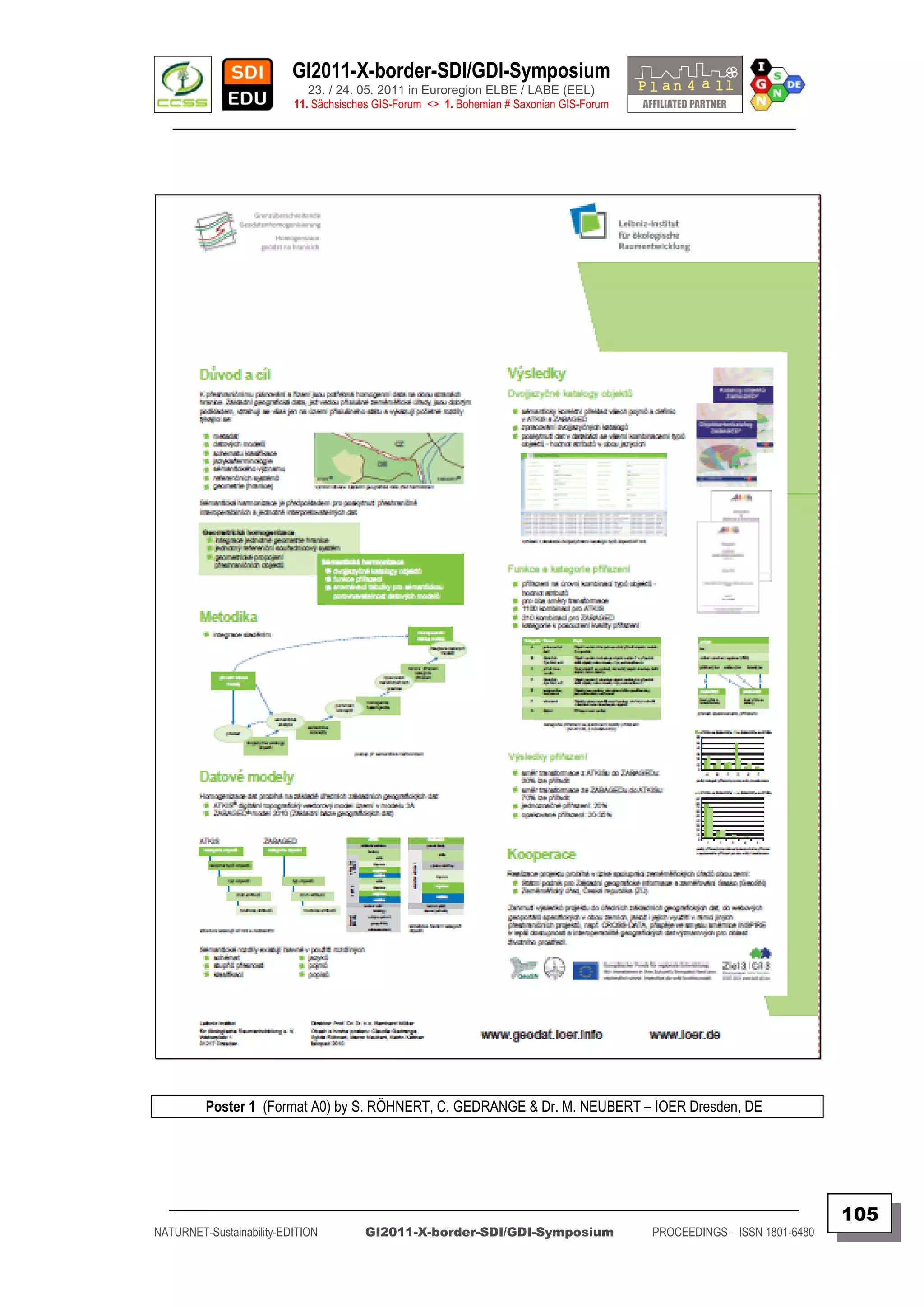
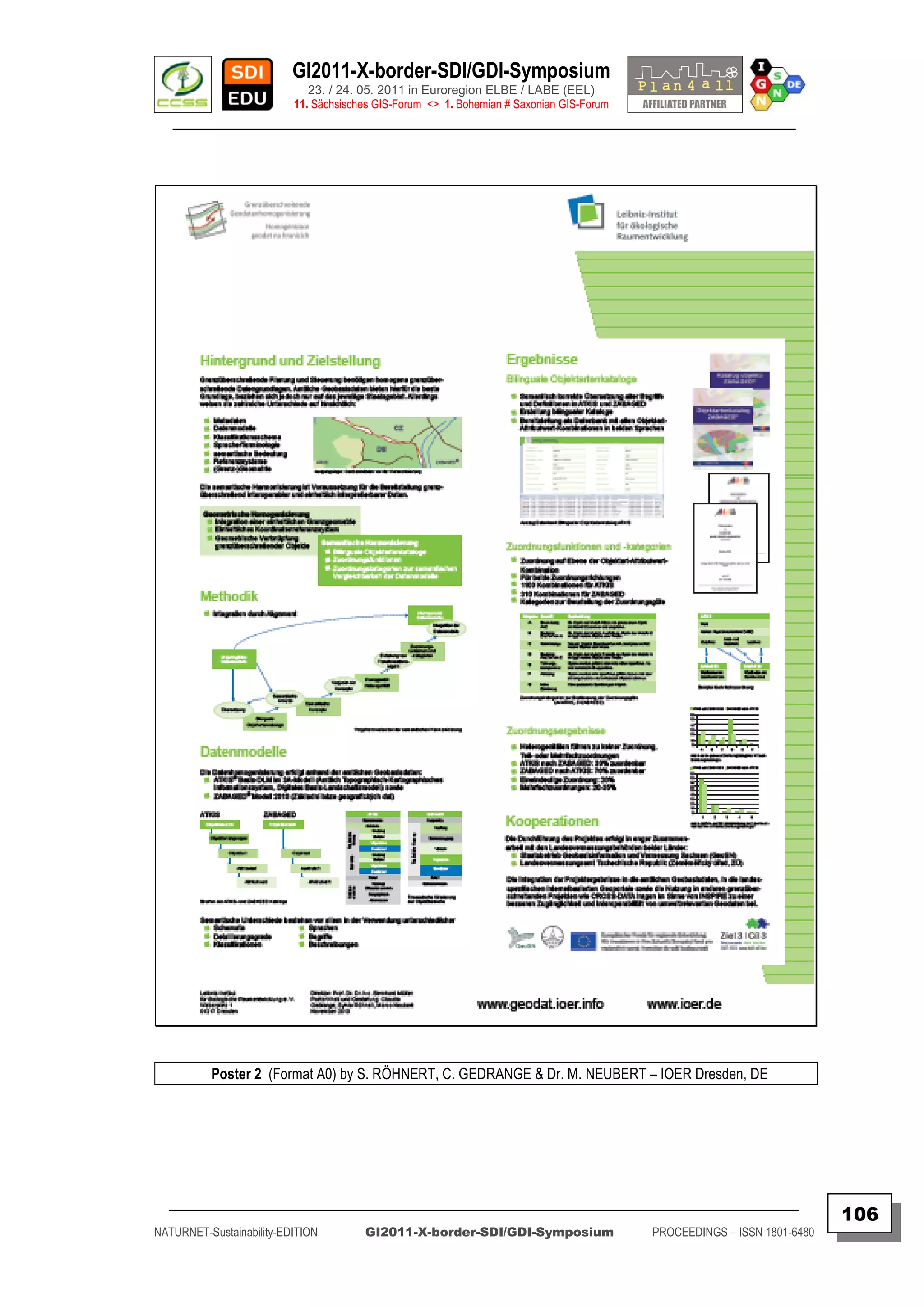

The document announces an inter-regional symposium on cross-border spatial data infrastructures (SDIs)/geographic data infrastructures (GDIs) to be held on May 23-24, 2011 in Bad Schandau, Germany and Decin, Czech Republic. The goal is to share knowledge on progress integrating SDIs across European border regions in line with EU directives on public sector information reuse and INSPIRE. The agenda includes sessions on cross-border data sharing, SDI integration and applications, as well as a roundtable discussion. Participants will learn about best practices from existing cross-border geoportals and projects like NATURNET, and discuss challenges of implementing INSPIRE in border


