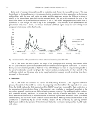
This document summarizes a study that used the Generalized Likelihood Uncertainty Estimation (GLUE) method to analyze parametric uncertainty in hydrological modeling of the Kootenay Watershed in Canada. The study used the SLURP hydrological model and analyzed over 1 million parameter combinations using the GLUE method. The results identified distributions for key model parameters and showed variability in parameter averages and distributions between different land cover types within the watershed. This provided insights into parametric uncertainties and improved understanding of hydrological processes in the study area.
The Development of a Catchment Management Modelling System for the Googong Re...GavanThomas
A scenario assessment model to assist the end-user in determining priorities for a series of agreed management prescriptions that can be enacted through controls on existing landuse
Streamflow simulation using radar-based precipitation applied to the Illinois...Alireza Safari
This paper describes the application of a spatially distributed hydrological model WetSpa (Water and Energy Transfer between Soil, Plants and Atmosphere) using radar-based rainfall data provide by the United States Hydrology Laboratory of NOAA's National Weather Service for a distributed model intercomparison project. The model is applied to the
river basin above Tahlequah hydrometry station with 30-m spatial resolution and one hour time--step for a total simulation period of 6 years. Rainfall inputs are derived from radar. The distributed model parameters are based on an extensive database of watershed characteristics available for the region, including digital maps of DEM, soil type, and land use. The model is calibrated and validated on part of the river flow records. The simulated hydrograph shows a good correspondence with observation (Nash efficiency coeffiecient >80%, indicating that the model is able to simulate the relevant hydrologic processes in the basin accurately.
A major challenge in hydrological modelling is to identification of optimal
parameter set of different data, catchment characteristics and objectives. Although, the
identification of optimal parameter set is difficult because of conceptual hydrological
models contain more number of parameters and accuracy also depends upon all the
relevant number of parameters influencing in a model. This identification process
cannot estimate directly and therefore it measured based on calibrating the model
which minimizing an objective function. Here, the objective function can depend upon
the sensitivity of model parameters and calibration of model. In this paper, we proposed
the Emulator Based Optimization (EBO) for reducing number of runs and improving
conceptual model efficiency. Where, emulator models are used to represent the
response surface of the simulation models and it can play a valuable role for
optimization. In this study evaluates EBO for calibrating of SWAT hydrological model
with following steps like input design, simulation model, emulator modelling,
convergence criteria and validation. The results show that EBO calibrates the model
with high accuracy and it captured the observed model with consuming less time. This
study helps for decision making, planning and designing of water resources.
Using Computer-simulated hydrological model (SWAT) to estimate the ground-wat...Dhiraj Jhunjhunwala
This work is the result of a project-based course, Water Resources Engineering. The project is about the estimation of ground-water recharge due to rainfall in a US-based watershed. The semi-distributed hydrological model(SWAT) has been used to simulate the monthly input and output sub-basin-wise streamflow values,which have been used to compute the total infiltration. The results have been depicted in th form of various monthy and yearly infilration values
New Approach of Prediction of Sidoarjo Hot Mudflow Disastered Area Based on P...Waqas Tariq
A new approach of prediction of Sidoarjo hot mudflow disastered area based on cellular automata with probabilistic adjustment for minimizing prediction errors is proposed. Sidoarjo hot mudflow has specific characteristics such as plane and complex area, huge mud plumes, high viscosity and surface temperature changes, so that it needs combined approaches of slow debris flow, and material changes caused by viscous fluid and thermal changes. Some deterministic approaches can not show the high state changes. This paper presents a new approach of cellular automata using probabilistic state changing to simulate hot mudflow spreading. The model was calibrated with the time series of topological maps. The experimental results show new inundated areas that are identified as high risk areas where are covered by mud. It is also show that the proposed probabilistic cellular automata approach works well for prediction of hot mudflow spreading areas much accurate than the existing conventional methods.
Coupling Monitoring Networks and Regional Scale Flow Models for the Managemen...joaoambiente
Automatic monitoring networks were settled to provide datasets for the calibration
and validation of regional flow models, as a strategy to complement data available in official
monitoring networks for the main regional aquifers in Algarve (Portugal). The Almádena-
Odeáxere aquifer system is presented as an example, where the comparative analysis of
variables representing “reality”, consisting of data obtained in these networks, was made
against values simulated with a finite element numeric model. This methodology contributed
for a better calibration and validation of the model, together with the design of effective
groundwater monitoring networks, at the regional scale.
Climate Change Impact Assessment on Hydrological Regime of Kali Gandaki BasinHI-AWARE
The presentation focuses on the findings of the impact of climate change on the hydrological regime and water balance components of the Kali Gandaki basin in Nepal. The Soil and Water Assessment Tool (SWAT) has been used to predict future projections.
Assessment of Water Quality in Imo River Estuary Using Multivariate Statistic...IOSR Journals
Abstract: The water quality of Imo River Estuary, the Niger Delta region was studied for a duration of 12 months. This study was aimed at the assessment of water quality parameter of the water body. In order to have an indepth knowledge to the physical and chemical processes as well as their associated spatial distribution, the study analyses some parameters recorded at the three sampling sites through multivariate statistical methods. The principal component analysis (PCA) and factor analysis (FA) was employed to extract and recognize the major underlying factors contributing to the variations among the water quality measured. Results indicate that three principal components, that is nutrients, organic and meteorological factor account for 99.91% of the total variance among the water quality parameters. The spatial distribution of principal components further confirms that nutrient sources constitute the main pollutant contribution. Keywords: Assessment, Principal Component Analysis, Factor Analysis, Estuary, Source
DEVELOPING THE OPTIMIZED OCEAN CURRENT STRENGTHENING DESALINATION SEMI-PERMEA...ijbesjournal
Alongside improvements in desalination operation and development of new technologies, problems of weakened counter current and global warming have emerged. Therefore, our study suggests a new desalination model, based on the experimental Support Vector Machine (SVM) algorithm, for semipermeable membrane separation. First, the reverse osmosis (RO) process used semi-permeable membrane and osmotic pressure to remove the solutes dissolved in seawater and obtain pure freshwater. The desalination process also applied MSF and MED, which are the best technologies developed through elimination of various problems that were previously experienced. This research is directed towards suggesting a model that can effectively create the semi-permeable membrane used in the desalination process. To efficiently prevent a counter current and safely obtain the water resources, an innovative technology is suggested by applying Genetic Algorithm (GA) to the SVM model for the semi-p
Disaggregation of Annual to daily Streamflows: A lineardeterministic methodIOSRJAP
In this study, a linear deterministic methodis applied to disaggregate streamflow from annual to daily data inunregulated stations located on the Kızılırmak river in Turkey. To disaggregate annual streamflows to the daily flow at the target station (TS), annual counterparts at the source station (SS) were identified depending on the minimum error criteria that is estimated based on the volume of three-year time window. Then, daily streamflow indexes at SS were calculated to disaggregate annual to daily streamflow at TS through the process. The same steps are replicated to disaggregate monthly streamflow to the daily flow for the purpose of comparison between the two methods. The results are well represents daily streamflow at two methods inquiry comparing to observe data, and also maintain the time series statistical characteristics and mass equilibrium. The comparative results suggest that the monthly to daily disaggregation method perform better than annual to the daily disaggregation method. The daily streamflow generated in this study can be used in the future research for water resources planning and management.
Creel Product Overview; Digital Commerce Starts With CreelGame-Consultant.com
Everyone has some forms of digital assets such as airmiles, loyalty points, in-game credits etc, but no single wallet to organise and spend these through. So how can you manage all your digital assets and as a merchant capitalise on this? This is simple with Creel – the only platform, which lets you exchange, manage and spend all your digital assets within one single wallet.
Islamabad Local Government Bill 2015. This report cover i) critical Analysis ii) Administration and political power iii) Election process and iv) Local government finance and revenue power
Urban Land Record and Management: Current practices & Challenges and way forwardWaseem Sajjad
What are the main urban land record and management in Pakistan--a case study of Lahore
What is Patwari Culture? What are the problems of Patwari Culture?
Land Record Management and Information System LRMIS
Performance comparison of SVM and ANN for aerobic granular sludgejournalBEEI
To comply with growing demand for high effluent quality of Domestic Wastewater Treatment Plant (WWTP), a simple and reliable prediction model is thus needed. The wastewater treatment technology considered in this paper is an Aerobic Granular Sludge (AGS). The AGS systems are fundamentally complex due to uncertainty and non-linearity of the system makes it hard to predict. This paper presents model predictions and optimization as a tool in predicting the performance of the AGS. The input-output data used in model prediction are (COD, TN, TP, AN, and MLSS). After feature analysis, the prediction of the models using Support Vector Machine (SVM) and Feed-Forward Neural Network (FFNN) are developed and compared. The simulation of the model uses the experimental data obtained from Sequencing Batch Reactor under hot temperature of 50˚C. The simulation results indicated that the SVM is preferable to FFNN and it can provide a useful tool in predicting the effluent quality of WWTP.
Hydrological Calibration in the Mount Lofty Ranges using Source Paramenter Es...eWater
The catchments of the Mount Lofty Ranges (MLR) provide a crucial water resource for the rural and urban community of Adelaide. The Source Catchments model is one planning tool used to assess current and future water, sediment and nutrient yields from the catchment. The modelling is critical for future planning to ensure a safe and reliable water supply is maintained.
Linking PEST and Source Catchments for hydrology calibration was an efficient and repeatable method for calibration. Future work to improve the process could include calibrating with other rainfall runoff models such as Sacramento which better account for groundwater losses or explicit representation of groundwater in the model.
This project has focused solely on rainfall and runoff. It has not considered how external impacts (e.g. climate change) may change catchment hydrological characteristics or constituent characteristics such as EMC/DWC values. Future projects through the Goyder Water Research Institute aim to address some of these
issues. This project may produce data which will inform further work in this respect.
IJRET : International Journal of Research in Engineering and Technology is an international peer reviewed, online journal published by eSAT Publishing House for the enhancement of research in various disciplines of Engineering and Technology. The aim and scope of the journal is to provide an academic medium and an important reference for the advancement and dissemination of research results that support high-level learning, teaching and research in the fields of Engineering and Technology. We bring together Scientists, Academician, Field Engineers, Scholars and Students of related fields of Engineering and Technology
Narayan Shrestha [Step wise multi-criteria performance evaluation of rainfall...Narayan Shrestha
The first author of the paper is Mr. Shakti PC who is currently in Japan. This paper is published in Journal of Hydrology and Meteorology Nepal (Vol. 7, No. 1) on December 2010.
APPLICATION OF GENE EXPRESSION PROGRAMMING IN FLOOD FREQUENCY ANALYSISMohd Danish
Flood frequency and its magnitude are essential for the proper design of hydraulics structures such as bridges, spillways, culverts, waterways, roads, railways, flood control structures and urban drainage systems. Since, flood is a very complex natural event depending upon characteristics of catchment, rainfall conditions and various other factors, thus its analytical modelling is very difficult to pursue. Recently, artificial intelligence techniques such as gene expression programming (GEP), artificial neural network (ANN) etc. have been found to be efficient in modelling complex problems in hydraulic engineering. The performance of GEP model has been reported to be better than that of the ANN. Moreover, GEP provides mathematical equation which makes it more superior over other soft computing techniques that do not give any analytical mathematical equation. Therefore, in present study, GEP is implemented in flood frequency analysis for typical Indian river gauging station. The results obtained in the present study are highly promising and suggest that GEP modelling is a versatile technique and represents an improved alternative to the more conventional approach for the flood frequency analysis.
Prediction of scour depth at bridge abutments in cohesive bed using gene expr...Mohd Danish
The scour modelling in cohesive beds is relatively more complex than that in sandy beds and
thus there is limited number of studies available on local scour at bridge abutments on cohesive
sediment. Recently, a good progress has been made in the development of data-driven techniques
based on artificial intelligence (AI). It has been reported that AI-based inductive modelling
techniques are frequently used to model complex process due to their powerful and non-linear model
structures and their increased capabilities to capture the cause and effect relationship of such
complex processes. Gene Expression Programming (GEP) is one of the AI techniques that have
emerged as a powerful tool in modelling complex phenomenon into simpler chromosomal
architecture. This technique has been proved to be more accurate and much simpler than other AI
tools. In the present study, an attempt has been made to implement GEP for the development of
scour depth prediction model at bridge abutments in cohesive sediments using laboratory data
available in literature. The present study reveals that the performance of GEP is better than nonlinear
regression model for the prediction of scour depth at abutments in cohesive beds.
Nonlinear filtering approaches to field mapping by sampling using mobile sensorsijassn
This work proposes a novel application of existing powerful nonlinear filters, such as the standard
Extended Kalman Filter (EKF), some of its variants and the standard Unscented Kalman Filter (UKF), to
the estimation of a continuous spatio-temporal field that is spread over a wide area, and hence represented
by a large number of parameters when parameterized. We couple these filters with the powerful scheme of
adaptive sampling performed by a single mobile sensor, and investigate their performances with a view to
significantly improving the speed and accuracy of the overall field estimation. An extensive simulation work
was carried out to show that different variants of the standard EKF and the standard UKF can be used to
improve the accuracy of the field estimate. This paper also aims to provide some guideline for the user of
these filters in reaching a practical trade-off between the desired field estimation accuracy and the
required computational load.
MODELING THE CHLOROPHYLL-A FROM SEA SURFACE REFLECTANCE IN WEST AFRICA BY DEE...gerogepatton
Deep learning provide successful applications in many fields. Recently, machines learning are involved for oceans remote sensing applications. In this study, we use and compare about eight (8) deep learning estimators for retrieval of a mainly pigment of phytoplankton. Depending on the water case and the multiple instruments simultaneously observing the earth on a variety of platforms, several algorithm are used to estimate the chlolophyll-a from marine reflectance.By using a long-term multi-sensor time-series of satellite ocean-colour data, as MODIS, SeaWifs, VIIRS, MERIS, etc…, we make a unique deep network model able to establish a relationship between sea surface reflectance and chlorophyll-a from any measurement satellite sensor over West Africa. These data fusion take into account the bias between case water and instruments.We construct several chlorophyll-a concentration prediction deep learning based models, compare them and therefore use the best for our study. Results obtained for accuracy training and test are quite good. The mean absolute error are very low and vary between 0,07 to 0,13 mg/m
MODELING THE CHLOROPHYLL-A FROM SEA SURFACE REFLECTANCE IN WEST AFRICA BY DEE...ijaia
Deep learning provide successful applications in many fields. Recently, machines learning are involved for oceans remote sensing applications. In this study, we use and compare about eight (8) deep learning estimators for retrieval of a mainly pigment of phytoplankton. Depending on the water case and the multiple instruments simultaneously observing the earth on a variety of platforms, several algorithm are used to estimate the chlolophyll-a from marine reflectance.By using a long-term multi-sensor time-series of satellite ocean-colour data, as MODIS, SeaWifs, VIIRS, MERIS, etc…, we make a unique deep network model able to establish a relationship between sea surface reflectance and chlorophyll-a from any measurement satellite sensor over West Africa. These data fusion take into account the bias between case water and instruments.We construct several chlorophyll-a concentration prediction deep learning based models, compare them and therefore use the best for our study. Results obtained for accuracy training and test are quite good. The mean absolute error are very low and vary between 0,07 to 0,13 mg/m3 .
2. 220 P. Vallam et al. / APCBEE Procedia 10 (2014) 219 – 223
diversification in the applications of hydrological models, general analysis of model outputs gains pre-
eminence over improving accuracy for a particular case study. This analysis of model outputs to determine
their uncertainty is performed by using different techniques. Divided broadly into Bayesian based and non-
Bayesian based techniques, the uncertainty in most hydrologic models can be analyzed. In this study, a robust
uncertainty analysis technique, i.e. Generalized Likelihood Uncertainty Estimation (GLUE) method, is used.
2. Methodology and Study Case
The hydrological model employed in this study is the Simple LUmped Reservoir Parametric (SLURP)
model developed by Kite [1]. The SLURP model has been applied for different snow watersheds and has been
determined robust [2], [3]. The technical details of the model can be referred to Kite [1]. To enable a thorough
study of the parametric uncertainty of the SLURP model, the Kootenay Watershed was modeled. The
temperature data and relative humidity data for this particular case study were obtained from CFSR website.
Other flow data and meteorological data at the different stations were obtained from the Hydat database and
the Canada Daily Climate Data. The Kootenay Watershed is divided into three different ASAs and their
characteristics could be found in Kite [1]. The streamflows from the Crossing ASA flow into Canal ASA and
then onto Skookum ASA, which makes Skookum the outlet for the watershed. The calibration period (1979-
1988) was performed using 3653 continuous daily flow data followed by a verification period (1989-1990) for
760 continuous daily outflows at Skookum. The Kootenay Basin is a remote mountainous watershed and has
not seen any significant human settlements during the calibration-verification period. Hence it is assumed that
the land-cover percentages are constant throughout the entire period. No visible major water diversionary
structures were found in the period of study, removing any need to alter the output of the model to reflect this.
The uncertainty analysis method is based on GLUE. It is an Equifinality based method presented by Beven
and Binley [4] using likelihood measures. It has been proven to be robust for uncertainty analysis of different
case studies [5]. This method is a Bayesian-type uncertainty analysis technique which makes use Maximum
Likelihood Estimators to evaluate the performance of different parameter ensembles. The method considers
every parameter ensemble to have equal likelihood to yield sufficiently accurate outputs i.e. flows. The
significant advantage of the GLUE method is its ability to determine parameter uncertainty from all sources:
parameter, model structure and input [6]. Another advantage of the GLUE method is its flexibility and
simplicity which guarantees a wide range of application as evidenced in numerous examples in literatures [6,
7, 8, 9]. Therefore, this methodology which combines GLUE with SLURP, examines the parametric
uncertainty using likelihood estimators, proving to be a novel application of this method. The SLURP manual
by Kite [1] describes the ten most sensitive parameters and their bounds.
In this application of the GLUE method, the Nash Sutcliffe Efficiency (NSE) is utilized as the likelihood
estimator [10]. The NSE determines the magnitude of residual variance when the simulations are compared to
the observed flow. It has been the likelihood estimator for many GLUE studies using other models, including
SWAT [6], Institute of Hydrology Distributed Model [4], ADM model [5], etc. In the absence of a prior
distribution, the uniform distribution was adopted as recommended by previous researchers [6]. The random
values were generated using Matlab software subject to the limits described in Kite [1]. To ensure a rigorous
process of choosing the parameter ensembles, one million parameter ensembles were created. To further
improve the sampling process, Latin Hypercube Sampling Scheme was employed. To account for the three
different land-covers (i.e. Impervious, Forest and Crop/Grass) three different sets of the million ensembles
were created (a total of three million ensembles) for analysis. In the GLUE methodology, the definition of
threshold is subjective. The likelihood measure is accorded a value which each parameter ensemble must
exceed to be considered a physically representative ensemble. Usually, when the NSE is employed as the
likelihood measure, a threshold value of approximately 0.5 has been suggested [6]. However, given that a
3. 221P. Vallam et al. / APCBEE Procedia 10 (2014) 219 – 223
larger number of parameter ensembles were created, the threshold level for the likelihood measure was set at
0.75.
3. Results and Discussion
3.1. Parameter analysis
The model was run using the parameter ensembles, and the NSE values were obtained for each run. Based
on the NSE values, 32221 distinct parameter ensembles were found to be successful. An analysis of the
statistical properties of each parameter, for each land-cover is conducted. The Initial contents of snow storage
parameter demonstrated the effect of land-cover in yielding more accurate outflows, by averaging differently
in each land-cover. Similarly, for the Forest land-cover, Initial contents of snow storage exhibited a
significantly higher skewness, indicative of higher asymmetry in the probability distributions. The modeled
distribution for each parameter was based on the Kolmogorov-Smirnov Test. The modeled distributions for
Initial contents of snow storage in Impervious land-cover is the Beta General distribution, Forest land-cover is
the Weibull distribution and Crop land-cover is the Weibull distribution (Figure 1).
Fig. 1. Probability Distribution Function plots for Initial Contents of Snow Storage for different Land-Covers
The distribution breakdown for the thirty parameters indicated that the Uniform distribution was the most
appropriate distribution fitting, followed by the Beta General distribution. Uniform distribution specifies that
the prior and the posterior distributions remain unchanged for parameters such as Initial contents of slow
storage (Impervious), Maximum infiltration rate (all land-covers), Retention capacity for slow storage (Imp.
and Crop/grass), Maximum capacity for slow storage (Imp., Forest), Precipitation factor (Imp., Crop/grass)
and P10 (Imp.). The variance exhibited by the successful parameter ensembles signifies the variability of the
posterior parameter. The variance of P 10 in the Forest land-cover is of particular significance given the
contrasting values obtained when compared to other land-covers. This may be attributed to the statistical
accuracy of this parameter being centered within a narrow band, also simultaneously underscoring the
variation in the averages of the parameter. Also important to note is the variation of skewness which may
change signs for the same parameter in different land-covers (for Maximum capacity for slow storage). This
may be ascribed to the nature of the parameter, which is used in computing slow storage in conjunction with
parameters: Initial contents of slow storage and Retention capacity for slow storage. The strongly positive
skewness for fast and slow storages, indicate that in the watershed, the runoff is more likely to be high from
the forest land-cover. Another aspect of the GLUE method is the property of Equifinality. In the one million
runs, many parameter ensembles generated similar likelihood values. For example, 36 different parameter
ensembles yielded the NSE value of 0.69.
3.2. Uncertainty in Simulations
4. 222 P. Vallam et al. / APCBEE Procedia 10 (2014) 219 – 223
In the peak of summer, the model was able to predict the peak flows with reasonable accuracy. This may
be attributed to the model structure, which ensures that the precipitation incident accumulates as fast storage
and combines with the snow melt producing peaks. Multiple peaks may account for different incidents of
rainfall in the mountainous watershed over the summer period. The lag in the autumn of first year of the
verification period can be attributed to the structure of the SLURP model. The preponderance of the flow to
accumulate as slow storage, can lead to lags in the hydrographs. This is reflected by the parameters for the
predominant land-cover – Forest. The related parameters exhibited higher values for slow storage when
compared to fast storage within their bounds.
Fig. 2. Confidence interval at 95th
percentile for the outflows in the watershed for the period 1989-1990
The SLURP model was able to predict the shapes of the hydrographs with accuracy. The contrast within
the two year verification period manifested when the low and medium flow periods are tracked. The observed
flows possessed similar magnitudes to the lower bound in the first year and were in comparable magnitudes to
the upper bounds in the second year (Figure 2). There are certain anomalies in the low flow periods of the
verification period, and this could arise as the model calibration is geared towards predicting large flows
accurately in the watershed.
4. Conclusion
The SLURP model was calibrated and verified for the Kootenay Watershed. After a rigorous calibration
process, the output of the model was verified by comparing with observed flow for a period of two years.
Using the GLUE method, the thirty parameters of the SLURP model were examined for their contribution to
the uncertainty of the predictions. Some of the parameters were concluded to significantly contribute to the
uncertainty, although variations across different land-covers were observed. The model predicted the outflows
with reasonable accuracy and hence can be used for future modeling of similar watersheds. The upper and
lower bounds were customarily in accordance to the overall flow regime of the watershed for the years 1989-
1990 validating the use of this model for future studies in the basin. Although some concerns remain on the
contribution to uncertainty by the model structure, analysis of the uncertainty by applying different
hydrological models to the Kootenay Watershed would further the comparative analysis of the SLURP model
with others.
5. 223P. Vallam et al. / APCBEE Procedia 10 (2014) 219 – 223
Acknowledgments
This research was supported by Singapore’s Ministry of Education (MOE) AcRE Tier 1 Project
(M4010973.030) and Tier 2 Project (M4020182.030).
References
[1] Kite GW. Manual for the SLURP Hydrologic Model V. 11. Saskatoon, Canada: NHRI; 1997.
[2] Kite GW. Watershed modelling using land classification. Water Resour Research 1992;28:3193-3200.
[3] Thorne R, Woo M. Efficacy of a hydrologic model in simulating discharge from a large mountainous catchment. J of Hydrol
2006;330:301-312.
[4] Beven K, Binley A. The future of distributed models: model calibration and uncertainty prediction. Hydrol Processes
1992;6:279-298.
[5] Montanari A, Brath A. A stochastic approach for assessing the uncertainty of rainfall-runoff simulations. Water Resour Res
2004;40:1-11..
[6] Shen ZY, Chen L, Chen T. Analysis of parameter uncertainty in hydrological model in simulating discharge from a large
mountainous catchment. J of Hydrol 2012;16:121-132.
[7] Aronica G, Bates PD, Horritt MS. Assessing the uncertainty in distributed model predictions using observed binary pattern
information within GLUE. Hydrol Processes 2002;16:2001-2016.
[8] Montanari A. Large sample behaviors of the generalized likelihood uncertainty estimation (GLUE) in assessing the uncertainty
in rainfall-runoff simulations. Water Resour Research 2005;41:1-13.
[9] Beven K, Freer J. Equifinality, data assimilation, and uncertainty estimation in mechanistic modelling of complex environmental
systems using the GLUE methodology. J of Hydrol 2001;249:11-29.
[10] Stedinger JR, Vogel RM, Lee SU, Batchelder R. Appraisal of the generalized likelihood uncertainty estimation (GLUE) method.
World Environment and Water Resources Congress Conf. Honolulu 2008;W00B06-1-17.