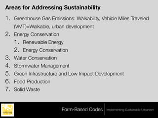
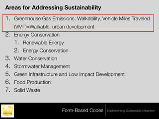
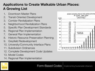
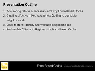
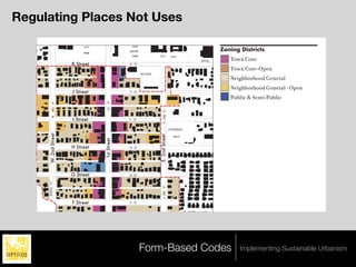
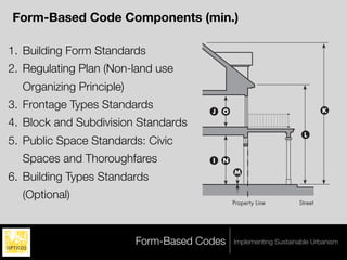
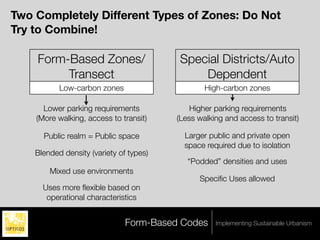
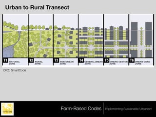
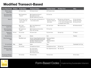
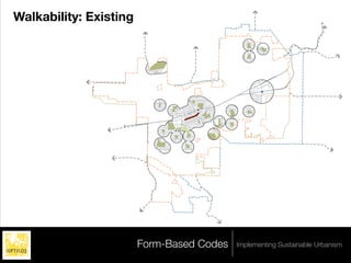
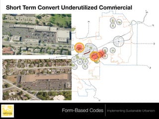
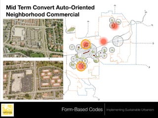
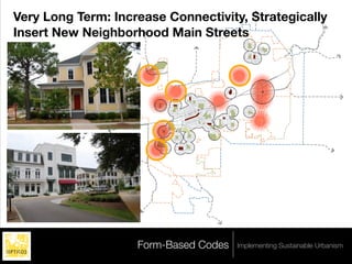
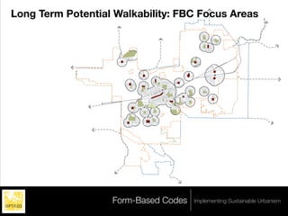
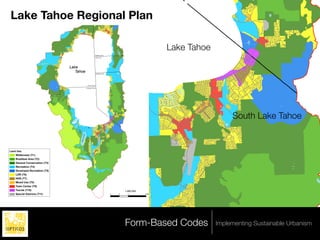
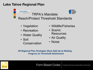
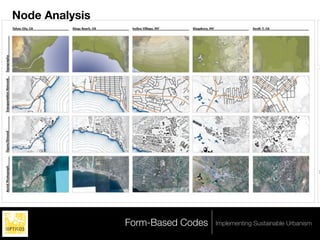
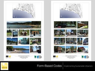
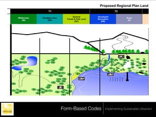
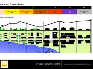
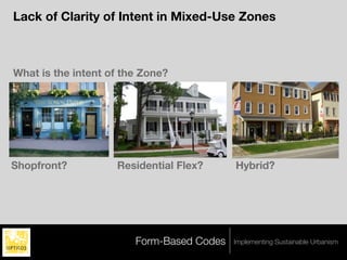
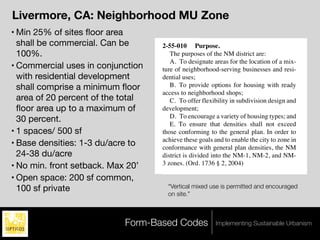
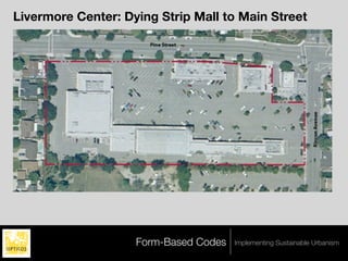
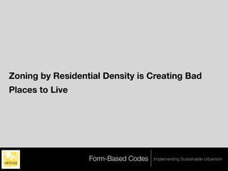
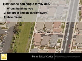
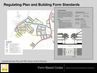
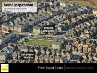
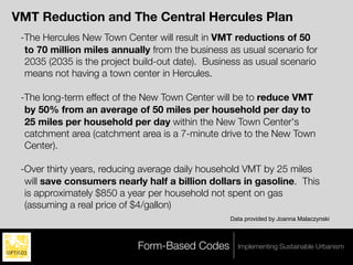
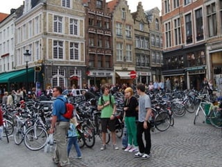
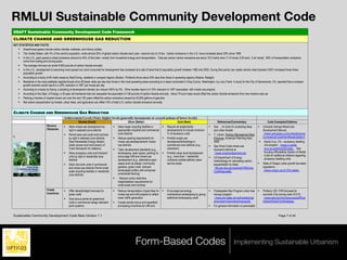
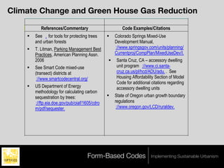
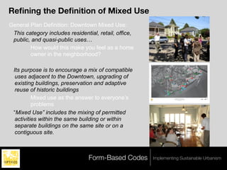
ACHIEVING SUSTAINABILITY USING
     FORM-BASED CODES
             AND
        THE TRANSECT
                    Daniel Parolek
           Principal, Opticos Design, Inc.
                      Bry Sarte,
       Principal, Sherwood Design Engineers
                   Roger Eastman
     Community Code Administrator, Flagstaff, AZ
                  Leslie Oberholtzer
          Dir. of Planning, Farr Associates

        Congress for the New Urbanism 2009
                  June 11th, 2009
                     Denver, CO
         daniel.parolek@opticosdesign.com
“Top 20 Ways to Make a Green, Smart City”

    #2 Replace Your Euclidean Zoning with Form-Based
    Codes

      Rob Dixon, Albuquerque developer in his keynote
      presentation at the New Partners for Smart Growth
      Conference, January 2009


                        Form-Based Codes       Implementing Sustainable Urbanism
Agenda
1.   Introduction: why are you here?
2.   Dan Parolek
3.   5-10 min. of Q&A
4.   Bry Sarte
5.   5-10 min. of Q&A
6.   Roger Eastman
7.   Leslie Oberholtzer
8.   1-20 min. of Q&A


                          Form-Based Codes   Implementing Sustainable Urbanism
D


                                                                                                                                    BTL, Property Line
      Form-Based Codes:                                                                                                                                                                     J   O


      Rethinking Zoning to                                                              G                            H


                                                                                                                                                         Side Street
                                                                                                 C                            B

      Make Walkable/                                                                             A                                           F
                                                                                                                                                                                            I   N
                                                                                                                                                                                                    M

      Sustainable Urbanism                                                  BTL, Property Line       Sidewalk            E


      the Default
                                                                                                 Primary Street
: Form-Based Code                                                                                                                                                                                   Property Line


                                                                          Key
 Core (TC) Standards                                                             Property Line                      Setback Line
                                                                                 Build-to Line (BTL)                Building Area

                                                                           Building Placement                                                                               Use
          Daniel Parolek
                                                                          Build-to Line (Distance from Property Line)                                                      Ground Floor                       Ser
          Principal, Opticos Design, Inc.                                 Front                                     0'                                            A                                           Re
          Congress for the New Urbanism 2009                              Side Street                               0'                                             B                                          Pu
                                D
          June 11th, 2009                                                 Setback (Distance from Property Line)                                                            Upper Floor(s)                     Re
          Denver, CO
                                       BTL, Property Line


                                                                          Side                                      0'                                             C       *See Table 4.1 for specific uses. G
          daniel.parolek@opticosdesign.com                                Rear                                                                                             terfront shall be nonresidential an
                                                                                            J     O                                                                    K
                                                                                 Adjacent to NG Zone                8'                                            D        garages, or similar uses.
                                                                                 Adjacent to any other Zone         5'                                            D
 G                         H
                                                                          Building Form                                                     L                               Height
                                                            Side Street


          C                        B                                      Primary Street Façade built to BTL 80% min.*                                             E       Building Min.                      22'
                                                                          Side Street Façade built to BTL           30% min.*                                      F       Building Max.                      2.5
                                                                          Lot Width
                                                                                            I     N                 125' max.                                              Max. to Eave/Top of Parapet 35'
                                                                                                                                                                  G
          A                                     F                                                        M
                                                                          Lot Depth                                 100' max.                                     H        Ancillary Building Max.            2s
                                                                          *Street façades must be built to BTL along first 30' from every corner.                          Finish Ground Floor Level          6"
ty Line       Sidewalk         E
                                                                          Notes                                                                                            First Floor Ceiling Height         12'
          Primary Street                                                  All floors must have a primary ground-floor entrance that
                                                                                                  Property Line             Street                                         Upper Floor(s) Ceiling Height 8' m
Areas for Addressing Sustainability
1. Greenhouse Gas Emissions: Walkability, Vehicle Miles Traveled
   (VMT)=Walkable, urban development
2. Energy Conservation
   1. Renewable Energy
   2. Energy Conservation
3. Water Conservation
4. Stormwater Management
5. Green Infrastructure and Low Impact Development
6. Food Production
7. Solid Waste


                         Form-Based Codes    Implementing Sustainable Urbanism
Applications to Create Walkable Urban Places:
A Growing List
1.    Downtown Master Plans
2.    Transit-Oriented Development
3.    Corridor Revitalization Plans
4.    Neighborhood Revitalization Plans
5.    Specific Plan Development Standards
6.    Regional Plan Implementation
7.    General Plan Implementation
8.    Historic Resource Preservation Planning
9.    Greyfield Redevelopment
10.   University/Community Interface Plans
11.   Subdivision Ordinances
12.   Complete Development Code Updates
13.   Model Codes
14.   Regional Plan Implementation

                              Form-Based Codes   Implementing Sustainable Urbanism
Presentation Outline
1. Why zoning reform is necessary and why Form-Based Codes
2. Creating effective mixed-use zones: Getting to complete
  neighborhoods
3. Small footprint density and walkable neighborhoods
4. Sustainable Cities and Regions with Form-Based Codes


                          Form-Based Codes      Implementing Sustainable Urbanism
1
Creating Walkable Urbanism: Where FBCs Can Be
the Most Effective
Zoning Reform: Removing Obstacles to Walkable
Urban Places


                 Form-Based Codes   Implementing Sustainable Urbanism
Getting to Compact Development & Lower VMT


   “The key to substantial greenhouse gas (GHG)
   reductions is to get all policies, funding, incentives,
   practices, rules, codes, and regulations pointing in
   the same direction to create the right conditions for
   smart growth.”

                “Growing Cooler” -Reid Ewing


                       Form-Based Codes        Implementing Sustainable Urbanism
Walkable Urban vs Drivable Sub-Urban Places
    “..these two kinds of places appear to perform
    fundamentally differently in how they lay out on the
    ground and how they perform regarding market
    acceptance, financial performance, rental rates/
    sales prices, tax revenue generation, and
    environmental sustainability. Finally, infrastructure
    investment, particularly in rail transit, and revised
    zoning regulations should be seriously considered
    by metropolitan area governments that are not
    seeing growth in this type of development pattern. ”

      “Option for Urbanism” -Chris Leinberger


                         Form-Based Codes       Implementing Sustainable Urbanism
Form-Based Codes as The Effective, Proven
Alternative


                 Form-Based Codes   Implementing Sustainable Urbanism
“Top 20 Ways to Make a Green, Smart City”

    #2 Replace Your Euclidean Zoning with Form-Based
    Codes

      Rob Dixon, Albuquerque developer in his keynote
      presentation at the New Partners for Smart Growth
      Conference, January 2009


                        Form-Based Codes       Implementing Sustainable Urbanism
Form-Based Codes
"As global society swings into
action to reduce carbon
emissions, the data ever more
clearly points to the need to            Form-Based Codes
reduce dependence on vehicular
mobility, and to remake the built
environment as transit- and
pedestrian-friendly places of
dense economic and social
interaction. Only the Form-Based                      A Guide for Planners, Urban Designers,
                                                             Municipalities, and Developers
Code can ensure such an
urbanism.”
                                          Daniel G. Parolek, AIA • Karen Parolek • Paul C. Crawford, FAICP
                                                        Forewords by Elizabeth Plater-Zyberk and Stefanos Polyzoides
           Elizabeth Plater-Zyberk


                            Form-Based Codes        Implementing Sustainable Urbanism
“Sustainable Urbanism” Tools for Implementation
 “By relating buildings back
 to the street and open
 spaces, rather than on
 parking lots or private yards,
 public spaces are redefined
 from the conventional
 automobile-oriented scale to
 the human or pedestrian-
 oriented scale. This focus
 allows form-based codes to
 guide the creation of active,
 sustainable neighborhoods.”


                         Form-Based Codes   Implementing Sustainable Urbanism
Role of FBCs in Lowering Carbon Emissions (GHG)
1. They provide a complete toolkit for regulating high-quality
   compact, walkable, development
2. The public outreach aspect provides needed education and
   community buy-in
3. They regulate for predictable results
4. They provide a predictable entitlements process for developers
   doing the right thing
5. They have proven to be effective in all of the above


                           Form-Based Codes   Implementing Sustainable Urbanism
Old Definition
 A method of regulating development to achieve a specific
  urban form.

 Form-Based Codes create a predictable public realm by
  controlling physical form primarily, with a lesser focus on
  land use, through city or county regulations.
                                     Form-Based Code Institute


                        Form-Based Codes       Implementing Sustainable Urbanism
New Definition
 "Form-based codes foster predictable built results and a
  high-quality public realm by using physical form (rather
  than separation of uses) as the organizing principle for the
  code. They are regulations, not mere guidelines. They are
  adopted into city or county law. Form-based codes are an
  alternative to conventional zoning."
                                    Form-Based Code Institute


                        Form-Based Codes      Implementing Sustainable Urbanism
'N'     ST


         Regulating Plan                                                                                                              EAST        MILITARY


         Regulating Places Not Uses                                                                                                                                                                                                                                                            EAST


                          W. 2ND ST
         Downtown Mixed Use Master Plan Area and Parcels South of B Street
                                                    SOLANO SQUARE
                                                                                               LIBRARY


                                            WEST    MILITARY                                              'L'         ST


                                                                                                                                                                                                                                       E. 5TH ST
                                                                                                                                                                 POST
                                                                                       CIVIC
                                                                                                                                                                             Zoning Districts
                                                   CITY
                                                                                                                                                                                            ELEMENTARY
                                                                                 CENTER
                                                   PARK
                                                                                       PARK                     CITY              HALL                                                                                             SCHOOL
                                                                                                                                                                OFFICE                            Town Core                                        'K'         ST
                                             K Street                             'K' ST
                                                                                                                                                                                                  Town Core-Open
                                                                                               YAC POOL
                                                                                                                                                                                                  Neighborhood General
                                                                                                                                                                                           B.U.S.D. OFFICES
                                                                                                                                                                                                          PRIORY    'J'                                        ST


                                                                                                                                                                                                  Neighborhood General - Open
                                                                                                                                                                                                          SCHOOL
                                             J Street                             'J' ST


                                                                                                                                                                                                                                                                         E. 6TH ST


                                                                                                                                                                                                                                                                                                              E. 7TH ST
                                                                                                                                                                                                  Public & Semi-Public                                   'I'        ST


                                                                                                                                                                                     E. 4TH ST
                                                                       ST
                         ST


                                                                                                                                                                         E. 3RD ST
                                                                       1ST
                          W. 2ND


                                                                                                                     E. 2ND ST
                                              I Street                           'I'    ST
                                                                                                                                                                                                                                                         'H'        ST

                                                                                                                                                                                     MARIA FIELD
                                                                                                                                 FITZGERALD
                    W. 2nd Street


                                                                                                                E. 2nd Street
                                                                                                                                    FIELD
                                                                                                                                                                                                                                                         'G'        ST
                                                                    1st Street


                                                                                                                                                                                                 RIBERO FIELD

                                             H Street


                                                                                                                                                                                                                           E. 5TH ST
                                                                                 'H' ST


                                                                                                                                                                                                                                                                                     BENICIA

SEMPLE   CROSSING                            G Street                            'G' ST                                                                                                                         TURNBULL                                                             WASTE WATER

                                                                                                                                                                                                                PARK                                                                 TREATMENT
                    SEMPLE CT


                                                                                                                     E. 2ND ST


                                                                                                                                                                                                                                                                                     PLANT


                                             F Street                             'F' ST


                                                                                                                                                                                                                                                                                                BENICIA CITY LIMITS
                                                                                                                                             'E' ST


                                                      E Street                   'E' ST                                                                                          MARINA CONDOMIUMS


                                                                                               Form-Based Codes
                                                                      ST


                                                                                                                                                                                                          Implementing Sustainable Urbanism
                                                                      1ST


                            SOUTHAMPTON
                                      BAY
                                                     D Street                    'D' ST                                                               BENICIA
                                                                                                                                                      MARINA
orm-Based Code

Core (TC) Standards Components (min.)
   Form-Based Code

      1. Building Form Standards
      2. Regulating Plan (Non-land use
                                D
           Organizing Principle)

                                        BTL, Property Line
      3. Frontage Types Standards                                          J   O                                 K

      4. Block and H
                   Subdivision Standards
                                                                                                         L
      5. Public Space Standards: Civic
       C                B
                                                             Side Street


           Spaces and Thoroughfares                                        I   N
      A                                          F                                 M
      6. Building Types Standards
ine       Sidewalk          E
           (Optional)
      Primary Street                                                               Property Line        Street


Line                    Setback Line
                                                              Form-Based Codes                     1" = 15'-0"
                                                                                   Implementing Sustainable Urbanism
Line (BTL)              Building Area
Two Completely Different Types of Zones: Do Not
Try to Combine!

    Form-Based Zones/                    Special Districts/Auto
         Transect                            Dependent
           Low-carbon zones                      High-carbon zones

      Lower parking requirements             Higher parking requirements
    (More walking, access to transit)    (Less walking and access to transit)

      Public realm = Public space          Larger public and private open
                                           space required due to isolation
    Blended density (variety of types)
                                            “Podded” densities and uses
        Mixed use environments
                                               Specific Uses allowed
      Uses more flexible based on
       operational characteristics


                               Form-Based Codes     Implementing Sustainable Urbanism
The Transect: A Shared Methodology


                 Form-Based Codes   Implementing Sustainable Urbanism
Urban to Rural Transect
l. TRANSECT ZONES


DPZ: SmartCode


                     Form-Based Codes   Implementing Sustainable Urbanism
Modified Transect-Based
Form-Based Code T2 Rural               T3 Sub-Urban              T4 General Urban                           T5 Urban Center             T6 Urban Core                            Other
      Whittier Uptown                  U-E: Uptown Edge          U-G: Uptown General                        U-CT: Uptown Center
        Specific Plan

    City of Grass Valley               NG-2: Neighborhood        NG-3: Neighborhood General-3               TC: Town Core
    Development Code                    General-2                NC: Neighborhood Center
                                                                 NC-Flex: Neighborhood Center-Flex

              Miami 21                 T3: Sub-Urban, with Re-   T4: Urban General, with Restricted, Lim-   T5: Urban Center, with      T6: Urban Core, with Restricted,         CI: Civic Institutional
                                        stricted, Limited, and    ited, and Open subsets                     Restricted, Limited, and    Limited, and Open subsets, and T6-8,    DI: Work Place District
                                        Open subsets                                                         Open subsets                -12, -24, -36, and -48 subzones based   D2: Industrial District
                                                                                                                                         on allowable number of floors

Santa Ana Renaissance                  UN-1: Urban               UN-1: Urban Neighborhood-1                 UC: Urban Center            RR: Rail Station Zone                    R/I: Resident/Industrial
         Specific Plan                   Neighborhood-1           CDR: Corridor

    Benicia Downtown                   NG: Neighborhood          NG-O: Neighborhood General-Open            TC: Town Core
     Form-Based Code                    General                  TC-O: Town Core-Open

          Montgomery       T2: Rural   T3: Sub-Urban             T4: General Urban                          T5: Urban Center            T6: Urban Core                           T1: Natural
           SmartCode

      Sarasota County                  Edge                      General                                    Core                                                                 Preserve

   Peoria Development                  West Main-Local           Sheridan Triangle-Neighborhood Center      Warehouse District-
                 Code                                            Prospect Road-Neighborhood Center           General
                                                                 West Main-Neighborhood Center              Warehouse District-
                                                                 West Main-Local Commerce                    Local

       St. Lucie County    Edge        General                   Center                                     Core                                                                 Countryside: Rural Fringe

   Leander SmartCode                   T3: Sub-Urban             T4: Neighborhood General                   T5: Neighborhood Center     T6: Urban Core

    Downtown Ventura                                             T4.1: Urban General                        T5.1: Neighborhood Center   T6.1: Urban Core
        Specific Plan                                             T4.2: Urban General 2
                                                                 T4.3: Urban General 3
                                                                 T4.4: Thompson Corridor

Blue Springs, MO Down-                 T3: Sub-Urban             T4: General Urban                          T5: Urban Center                                                     CS: Civic Space
town Development Code


                                                                                Form-Based Codes                                                 Implementing Sustainable Urbanism
Modified Transect-Based
Form-Based Code T2 Rural               T3 Sub-Urban              T4 General Urban                            T5 Urban Center             T6 Urban Core
      Whittier Uptown                  U-E: Uptown Edge          U-G: Uptown General                         U-CT: Uptown Center
        Specific Plan

    City of Grass Valley               NG-2: Neighborhood        NG-3: Neighborhood General-3                TC: Town Core
    Development Code                    General-2                NC: Neighborhood Center
                                                                 NC-Flex: Neighborhood Center-Flex

              Miami 21                 T3: Sub-Urban, with Re-   T4: Urban General, with Restricted, Lim-    T5: Urban Center, with      T6: Urban Core, with Restrict
                                        stricted, Limited, and    ited, and Open subsets                      Restricted, Limited, and    Limited, and Open subsets,
                                        Open subsets                                                          Open subsets                -12, -24, -36, and -48 subzon
                                                                                                                                          on allowable number of floo

Santa Ana Renaissance                  UN-1: Urban               UN-1: Urban Neighborhood-1                  UC: Urban Center            RR: Rail Station Zone
         Specific Plan                   Neighborhood-1           CDR: Corridor

    Benicia Downtown                   NG: Neighborhood          NG-O: Neighborhood General-Open             TC: Town Core
     Form-Based Code                    General                  TC-O: Town Core-Open

          Montgomery       T2: Rural   T3: Sub-Urban             T4: General Urban                           T5: Urban Center            T6: Urban Core
           SmartCode

      Sarasota County                  Edge                      General                                     Core

   Peoria Development                  West Main-Local           Sheridan Triangle-Neighborhood Center       Warehouse District-
                 Code                                            Prospect Road-Neighborhood Center            General
                                                                 West Main-Neighborhood Center               Warehouse District-
                                                                 West Main-Local Commerce                     Local

       St. Lucie County    Edge        General                   Center                                      Core

   Leander SmartCode                   T3: Sub-Urban             T4: Neighborhood General                    T5: Neighborhood Center     T6: Urban Core

    Downtown Ventura
        Specific Plan
                                                            Form-Based Codes
                                                               T4.1: Urban General
                                                               T4.2: Urban General 2
                                                                                                            Implementing Center T6.1: Urban Core
                                                                                                             T5.1: Neighborhood Sustainable Urbanism

                                                                 T4.3: Urban General 3
2
Taking Form-Based Codes to Scale
Development Code Updates


               Form-Based Codes   Implementing Sustainable Urbanism
Assessing City Application of Form-Based Zones
1. Downtowns: Mandatory
  •   Preserve, evolve or transform
2. Neighborhood Main Streets: Mandatory
  •   Preserve, evolve or transform
3. Historic Neighborhoods: Mandatory
  •   Preserve, evolve or transform
4. Aging strip corridors and greyfield sites: Optional or mandatory
  •   Evolve or transform
5. Other large opportunity sites: Optional or mandatory
6. New growth areas: Optional or mandatory


                            Form-Based Codes     Implementing Sustainable Urbanism
Testing Grounds:
•   City of Grass Valley (Adopted April 10, 2007)
    http://www.cityofgrassvalley.com/services/departments/cdd/pub_rev_docs.php#DC
•   Livermore, CA Development Code Update (Begun July 08)
    www.ci.livermore.ca.us/CDD/Planning/zoning_code_update.html
•   Flagstaff, AZ Development Code Update (Begun January 09)
    http://az-flagstaff2.civicplus.com/index.asp?NID=1416


Non-Opticos Codes:
• City of Miami (Public Review Draft)

    http://www.miami21.org/
•   Peoria, IL (Adopted June 17, 2007)
    http://www.heartofpeoria.com/code.html
•   City of Denver, CO (In progress)

                                   Form-Based Codes            Implementing Sustainable Urbanism
Assessing Where to Apply Form-Based Codes
at a City-Wide Scale


                  Form-Based Codes   Implementing Sustainable Urbanism
Assessing FBC Application: Neighborhoods/Centers


                  Form-Based Codes   Implementing Sustainable Urbanism
with Schools

                                                                       MS
                                                                             ES
                                                                        ES

                  JC


                                           ES
                   ES                           MS
                            ES                                  ES      ES
                                                PS
                                                     VS
                                            HS             MS
                                                                CS
                            HS
                       CS
                                      ES                  PS
                                 ES
                   ES
                    MS                ES


               Form-Based Codes                                      Implementing Sustainable Urbanism
with Transit

                                                                       MS
                                                                             ES
                                                                        ES

                  JC


                                           ES
                   ES                           MS
                            ES                                  ES      ES
                                                PS
                                                     VS
                                            HS             MS
                                                                CS
                            HS
                       CS
                                      ES                  PS
                                 ES
                   ES
                    MS                ES


               Form-Based Codes                                      Implementing Sustainable Urbanism
Trails, Schools, Parks


    Legend
        <all other values>
    ZONING
        OS-F


                             Form-Based Codes   Implementing Sustainable Urbanism
Walkability: Existing


    Legend
        <all other values>
    ZONING
        OS-F


                             Form-Based Codes   Implementing Sustainable Urbanism
Short Term Convert Underutilized Commercial


   Legend
       <all other values>
   ZONING
       OS-F


                            Form-Based Codes   Implementing Sustainable Urbanism
Mid Term Convert Auto-Oriented
Neighborhood Commercial


   Legend
       <all other values>
   ZONING
       OS-F


                            Form-Based Codes   Implementing Sustainable Urbanism
Very Long Term: Increase Connectivity, Strategically
Insert New Neighborhood Main Streets


    Legend
        <all other values>
    ZONING
        OS-F


                             Form-Based Codes   Implementing Sustainable Urbanism
Long Term Potential Walkability: FBC Focus Areas


    Legend
        <all other values>
    ZONING
        OS-F


                             Form-Based Codes   Implementing Sustainable Urbanism
Regional Plan Implementation


                 Form-Based Codes   Implementing Sustainable Urbanism
.
Figure 1
Lake Tahoe Regional Plan
Draft Land Use Map


                                                                                                                                                                         Lake Tahoe


                                                                                                                                      M ar
                                                                                                                                          let te
                                                                                                                                            Lake
                                                                  y
                                                                                                       Washoe County


                                                                Ba
                                                                                                          Carson City


                                           d
                                        al
                                     er
                                     Lake
                                Em              Tahoe                                                      Douglas County


                                                                e
                                                               ak

                                                                                          Placer County
                                                    eL


                                                                                        El Dorado County
                                          d
                                       ca
                                      se
                                     Ca


                                               e ra
                                                   ld
                                                          Ba
                                                            y
                                                                                                                                                                                           South Lake Tahoe
                                          Em
                                                          ke
                                                         La
                                                     de
                                                    ca
                                                se


                                                                                                                                        ke
                                               Ca


                                                                                                                                  a f La
                                                                                   ke
                                                                              af La
                                                                          n Le
                                                                    F alle


                                                                                                                              n Le


Land Use
    Wilderness (T1)
                                                                                                                        F alle


    Roadless Area (T2)
    General Conservation (T3)
    Recreation (T4)
    Developed Recreation (T5)
    LDR (T6)
    HDR (T7)
    Mixed Use (T8)
    Town Center (T9)
    Tourist (T10)                                                                                                                                  1:260,000
    Special Districts (T11)                                                                                                   0               2      4         8 Miles


                                                                                                                                                   Form-Based Codes                   Implementing Sustainable Urbanism
.
                                                         Figure 1
                                                         Draft Land Use Map
  Lake Tahoe Regional Plan:
   Transforming Auto-
   Dependent Development


                                                                                                                                                                                 M ar
                                                                                                                                                                                     let te
                                                                                                                                                                                       Lake
                                                                                                                                                        Washoe County
                                                                                                                                                           Carson City


  Land Use and Transportation                                                                Lake
                                                                                                Tahoe
  policies:
                                                                                                                                                            Douglas County


  • Walkable, more compact / higher-
                                                                                                                                           Placer County

                                                                                                                                         El Dorado County


    density, mixed-use development
  • Bicycle and pedestrian paths
  • Expansion of mass transit                                                                  Em
                                                                                                    e ra
                                                                                                        ld
                                                                                                               Ba
                                                                                                                 y


                                                                                                               ke
                                                                                                              La
                                                                                                          de
                                                                                                         ca
  • Advanced technologies for


                                                                                                     se
                                                                                                    Ca


                                                                                                                                    ke
                                                                                                                               af La
    automobiles


                                                                                                                           n Le
                                                                                                                     F alle
                                                         Land Use
                                                             Wilderness (T1)
                                                             Roadless Area (T2)
                                                             General Conservation (T3)
                                                             Recreation (T4)
                                                             Developed Recreation (T5)
                                                             LDR (T6)
                                                             HDR (T7)
                                                             Mixed Use (T8)
                                                             Town Center (T9)
http://www.trpa.org/default.aspx?tabindex=11&tabid=130       Tourist (T10)                                                                                                                    1:260,000
                                                             Special Districts (T11)                                                                                         0           2      4         8 Miles


                                          Form-Based Codes                               Implementing Sustainable Urbanism
Lake Tahoe Regional Plan

                TRPA’s Mandate:
        Reach/Protect Threshold Standards

          •   Vegetation             • Wildlife/Fisheries
          •   Recreation             • Scenic
          •   Water Quality            Resources
                                     • Air Quality
          •   Soil
              Conservation           • Noise

        !""!#$%&'()"!*")(!+,-),$%&$.!/0.,!!11!23!,'!/)4&(%!
                  *-'%-$..!'(!56-$.6'"1!!,,)&(7$(,!


                         Form-Based Codes        Implementing Sustainable Urbanism
Node Analysis


                Form-Based Codes   Implementing Sustainable Urbanism
Form-Based Codes   Implementing Sustainable Urbanism
Proposed Regional Plan Land Use
                                                       T1                                                                                      T2
k                                                                                     General                             Developed
             Wilderness                        Roadless Area                                                                                                  Rural                           Sub-U
                                                                                 Forest & Park Land                       Recreation
                 (W)                               (RA)                                                                                                        (R)                              (SU
                                                                                        (GF)                                (DR)


    These areas contain ecological,     These lands contain ecological,     These are areas with value as        These are primarily natural     These are areas that are           These are areas t
    geological, and other features of   geological, and other features of   natural areas, an interface          areas with good potential for   sparsely settled with large lot    single-family hous
    scientific, educational, scenic     scientific, educational, scenic     between primitive and urban          intensive outdoor recreation.   single-family houses (estates).    medium sized lots
    and historical value. Permanent     and historical value. Permanent     areas, with strong environmental     Recreation uses are designed to The majority of the land is        of the lot is landsc
    improvements and mechanized         improvements in character with      limitations on use, and with a       be harmonious with the          landscaped or maintained           maintained natura

                                                                       Form-Based Codes
    uses are prohibited.                the natural landscape and low-      potential for dispersed recreation   surrounding natural             natural environment. Setbacks      Setbacks are rela

    These lands are managed to
                                        impact motorized recreation are
                                        allowed.
                                                                            or low intensity resource
                                                                            management. Vegetation is
                                                                                                                                   Implementing Sustainable Urbanism
                                                                                                                 environment. They are
                                                                                                                 accessible via a variety of
                                                                                                                                                 are deep and varied. There is
                                                                                                                                                 minimum street connectivity, and
                                                                                                                                                                                    varied and garage
                                                                                                                                                                                    prominent on a la
    prevent the degradation of                                              managed to ensure public safety      transportation options.         the areas are isolated. Streets    of street elevation
    wilderness character. Natural                                           and healthy forest conditions.                                       widths vary and may or may not     minimum street co
stricts and Transect Zones
          T3                                                                     T4                                                    T5                                  T6                                  SD

n                 Neighborhood Edge                Neighborhood General                Neighborhood Center                           Town                                 Core                         Special District
                         (NE)                              (NG)                               (NC)                                    (T)                                  (C)                              (SD)


 onsist of     These are areas that primarily    These are areas that consist of These are mixed-use areas with           These are mixed-use areas with    These are the most intense           These are areas that because of
n large to     consist of single-family houses   medium density housing types      a vibrant public realm that           a vibrant public realm that        urban form areas that are            their unique land use
e majority     on medium to small sized lots     such as cottage courts, mansion provide services and amentities         provide services and amentities    generally designated as              characteristics require special
   or          with some existing cottage        apartments, duplexes,             for residents and visitors.           for residents and visitors.        community plan areas. These          districts. Their form is
 ironment.     courts and duplexes. The          fourplexes, and triplexes on      Buildings have shallow or no          Buildings have shallow or no       are visitor destination areas that   dependent upon their purpose.
 deep and      majority of the lot is still      medium to small sized lots.       setbacks, but there are regular       setbacks, but there are minor      have been designated to provide      The purpose of this
e              landscaped or maintained          These types are compatible in     breaks in the physical form           breaks in the physical form        commercial and public services       classification is to concentrate
 ercentage     natural environment. Setbacks     scale and form to adjacent lower- along the street edge provided        along the street edge provided     to the Region or have the            such services for public


                                                                                          Form-Based Codes
 ere is        are relatively deep and varied.   intensity residential, but yet    by side setbacks and varied           varied setbacks and frontages.     potential to provide future          convenience, separate
ctivity, and
 not near
               Strong street connectivity is
               present, and the areas are
                                                 intense enough to support
                                                 transit. The lot is an equal
                                                                                   setbacks and frontages. The
                                                                                   built form covers a majority of the
                                                                                                                         The built form covers a majority
                                                                                                                         of the site. Strong street
                                                                                                                                                            Implementing Sustainable Urbanism
                                                                                                                                                            commercial and visitor services
                                                                                                                                                            and mix use buildings with
                                                                                                                                                                                                 incompatible uses, and allow
                                                                                                                                                                                                 other noncommercial uses if
rcial          adjacent/proximate to             balance of built form             site. Strong street connectivity is   connectivity is present. Streets   commercial and residential           they are compatible with the
  vary and     commercial centers. Streets are   andlandscaped or maintained       present. Streets are narrow and       are narrow and pedestrian-         uses..                               purpose of this classification
urbs and       narrow and may or may not have    natural environment. Setbacks     pedestrian-oriented,should            oriented,should integrate wide                                          and other goals of this Plan.
3..
Making Mixed-Use Regulations Clear and Effective
Lack of Clarity of Intent in Mixed-Use Zones


What is the intent of the Zone?


Shopfront?          Residential Flex?      Hybrid?


                        Form-Based Codes   Implementing Sustainable Urbanism
2-55-020 Uses permitted.
                                       2-55-030 Uses permitted with conditional use
Livermore, CA: Neighborhood MU Zone             permit approval.                               e
                                       2-55-040 Minimum lot specifications and lot
• Min 25% of sites floor area                    development regulations.
  shall be commercial. Can be          2-55-010 Purpose.
  100%.                                   The purposes of the NM district are:                 a
                                          A. To designate areas for the location of a mix-
• Commercial uses in conjunction                                                               m
                                       ture of neighborhood-serving businesses and resi-
  with residential development         dential uses;
  shall comprise a minimum floor           B. To provide options for housing with ready
                                       access to neighborhood shops;
  area of 20 percent of the total         C. To offer flexibility in subdivision design and    d
  floor area up to a maximum of         development;
                                                                                               g
  30 percent.                             D. To encourage a variety of housing types; and
                                          E. To ensure that densities shall not exceed         tr
• 1 spaces/ 500 sf                     those conforming to the general plan. In order to       ro
• Base densities: 1-3 du/acre to       achieve these goals and to enable the city to zone in
                                       conformance with general plan densities, the NM
  24-38 du/acre                        district is divided into the NM-1, NM-2, and NM-
• No min. front setback. Max 20’       3 zones. (Ord. 1736 § 2, 2004)                          n

• Open space: 200 sf common,       2-55-020 Uses permitted.
  100 sf private                     “Vertical mixed use is permitted and encouraged
                                      The following uses are permitted subject to              m
                                     on site.”
                                   approval of a zoning use permit, design review as
                                   required under LPZC 5-05-110, and any other pre-            e
                                   requisite permits, and conformance to all applica-
                                   ble regulations set forth in this chapter and               in
                            Form-Based Codes code:
                                   elsewhere in this Implementing Sustainable Urbanism         a
                                      A. Commercial Uses. Up to 100 percent of the             m
Livermore Center: Dying Strip Mall to Main Street


                    Form-Based Codes   Implementing Sustainable Urbanism
Livermore Center: Dying Strip Mall to Main Street


                    Form-Based Codes   Implementing Sustainable Urbanism
Neighborhood Main Streets


                  Form-Based Codes   Implementing Sustainable Urbanism
Alternatives to Establish Regulatory Parameters


     Minimum Mix of Uses              Maximum Mix of Uses


                           Form-Based Codes   Implementing Sustainable Urbanism
Urban to Rural Transect as Starting Point
l. TRANSECT ZONES


                    Form-Based Codes   Implementing Sustainable Urbanism
Urban to Rural Transect as Starting Point
l. TRANSECT ZONES


                       T4-N            T4-MS
                    Neighborhood   Main Street/Center


                    Form-Based Codes     Implementing Sustainable Urbanism
03.18.08                                                                                                                                     05.27.08

t
         Form-Based Zones: Modified Transect
                      T3-NG                                     T4-NG                                        T4-NG-O                                         T4-MS                                         T4-MS-O


     T3-Neighborhood General                    T4-Neighborhood General                       T4-Neighborhood General -Open                 T4-Main Street                                  T4-Main Street-Open
     Desired Form                               Desired Form                                  Desired Form                                  Desired Form                                    Desired Form
    Residential                                Residential                                   Residential                                   Commercial/Shopfront                            Commercial/Shopfront
     General Use                                General Use                                   General Use                                   General Use                                     General Use
    Residential                                Residential                                   Open/Flexible: Residential, retail, general   Vertical mixed-use: Retail, general             Open/Flexible: Residential, retail, general
                                                                                             commercial, services, and public uses         commercial, services, and public on the         commercial, services, and public uses
                                                                                             mixed vertically and horizontally on a site   ground floors with residential or commer-       mixed vertically and horizontally on a site
                                                                                                                                           cial uses on upper floors.

     Intent                                     Intent                                        Intent                                        Intent                                          Intent
    The primary intent of this zone is to      The primary intent of this zone is to build   To provide an appropriate transition from     To integrate vibrant, main street com-          To provide an appropriate transition from
    protect the integrity and quality of the   upon the unique characteristics of Liver-     the neighborhood main street into the         mercial and retail environment into             the neighborhood main street into the
    downtown neighborhoods                     more's downtown neighborhoods, but to         residential areas, and to provide flexible    neighborhoods that will provide access          residential areas, and to provide flexible
                                               allow them to evolve with medium density      buildings that can allow the ground floor     to day to day amenities within walking          ground floor spaces in a commercial form
                                               building types such as bungalow courts,       commercial uses to expand as the market       distance, reinforce a potential transit stop,   that can allow the ground floor "shopfront
                                               duplexes, and mansion apartments, at a        desires.                                      and serve as a focal point for the neigh-       environment to expand as the market
                                               smaller scale compatible to its context.                                                    borhoods                                        desires.


                                                                                             Form-Based Codes                                                  Implementing Sustainable Urbanism
Subdivision Design and Process Standards
1. Require large sites to be broken down into streets and blocks
2. Prescribe a min. and maximum mix of form-based zones
   needed to meet intended goals. City should establish zones.
3. Provide flexible building types to allow commercial uses to
   respond to market demand
4. Think carefully about the amount of commercial/retail you
   require: HIstoric Centers typically 20,000-40,000
5. Put maximums on parking regulations
6. Review in stages: Do not require all building design up front.
   Approve a plan and regulating plan. Allow building review later.


                         Form-Based Codes     Implementing Sustainable Urbanism
Regulating Plan Draft


                    Form-Based Codes   Implementing Sustainable Urbanism
4
Encouraging Small Footprint Density & New Walkable
Neighborhoods
Zoning by Residential Density is Creating Bad
Places to Live


                  Form-Based Codes   Implementing Sustainable Urbanism
How dense can single family get?
1. Wrong building type
2. No street and block framework
(public realm)


                     Form-Based Codes   Implementing Sustainable Urbanism
Density Without Amenity


                                                  Density without amenity


                   Form-Based Codes   Implementing Sustainable Urbanism
Location of density


 T1   NATURAL
      ZONE      T2   RURAL
                     ZONE       T3 SUB-URBAN
                                   ZONE        T4   GENERAL URBAN
                                                    ZONE            T5 URBAN CENTER T6 URBAN CORE
                                                                       ZONE            ZONE         SD SPECIAL
                                                                                                       DISTRICT


                  Wrong place for density


SmartCode (Image Credit: DPZ)


                                            Form-Based Codes                   Implementing Sustainable Urbanism
Location of density


 T1   NATURAL
      ZONE      T2   RURAL
                     ZONE       T3 SUB-URBAN
                                   ZONE        T4   GENERAL URBAN
                                                    ZONE            T5 URBAN CENTER T6 URBAN CORE
                                                                       ZONE            ZONE         SD SPECIAL
                                                                                                       DISTRICT


                                                     Right place for density


SmartCode (Image Credit: DPZ)


                                          Form-Based Codes                     Implementing Sustainable Urbanism
Location of density


 T1   NATURAL
      ZONE      T2   RURAL
                     ZONE       T3 SUB-URBAN
                                   ZONE        T4   GENERAL URBAN
                                                    ZONE            T5 URBAN CENTER T6 URBAN CORE
                                                                       ZONE            ZONE         SD SPECIAL
                                                                                                       DISTRICT


                                     Where Has Zoning Left the Biggest Gap?


SmartCode (Image Credit: DPZ)


                                          Form-Based Codes                     Implementing Sustainable Urbanism
Blended density neighborhood in King City

Arboleda Specific Plan
King City, CA
Creekbridge Homes
King City, Density: How Do You Do This With Zoning?
 Blended CA

                  Townhouse
                  18 du/acre


  Mews House
  15 du/acre


                                                     Courtyard
                                                     30 du/acre


                          Single Family
                          9-13 du/acre


                    Form-Based Codes      Implementing Sustainable Urbanism
Courtyard Housing: 30 du/acre


                  Form-Based Codes   Implementing Sustainable Urbanism
Hercules, California
                                     •    San Francisco Bay Area
                                     •    Population: 19,488
                                     •    Contra Costa County
                                     •    Established as company
                                          housing by the California
                                          Powder Works in 1881


                       Form-Based Codes    Implementing Sustainable Urbanism
Regulating Plan and Building Form Standards
                                                                                                                                  3.!Main!Street!
                                                                                                                                  Main Street is lined with mixed-use shopfront          A.!Building!Placement:
                                                                                                                                  buildings that are positioned at the front of each
                                                                                                                                  lot. It features angled parking or parallel parking    Build-to-line location: 0 ft. from property
                                                                                                                                  and wide sidewalks. Trees in the right-of-way                                  line
                                                                                                                                                                            Four-Lane Avenue (p. **)
                                                                                                                                  are optional. Colonnades are encouraged, to help       Space Between           0 ft. if attached
                                                                                                                                  give the street narrower proportions and better        Buildings:              6–10 ft. if detached
                                                                                                                                                                            Two-Lane Avenue (p. **)
                                                                                                                                  spatial definition.
                                                                                                                                                                         Main Street (p. **)
                                                                                                                                  Notes:!!                                              B.!Building!Volume:!!
                                                                                                                                                                         Town Center Street (p. **)
                                                                                                                                                                                        Bldg. Width: 16 ft. minimum
                                                                                                                                  1. Appurtenances may extend beyondNeighborhood Street (p. **)
                                                                                                                                                                         the
                                                                                                                                                                                                      160 ft. maximum
                                                                                                                                     height limit.                       Neighborhood Lane (p. **)
                                                                                                                                  2. Building fronts are required to provide            Bldg. Depth: 125 ft. maximum
                                                                                                                                                                         Two-Way Edge Drive (p. **)
                                                                                                                                     shelter to the sidewalk by means of at least
                                                                                                                                                                                        Bldg. Height: 3 stories minimum
                                                                                                                                                                         One-Way Edge Drive (p. **) stories maximum
                                                                                                                                     one of the following: arcade, colonnade,
                                                                                                                                                                                                      5
                                                                                                                                     marquee, awning, or second-floor balcony.
                                                                                                                                                                                                          55 ft. maximum
                                                                                                                                  3. The alignment of floor-to-floor heights of
                                                                                                                                                                                                          The first floor shall be a
                                                                                                                                     abutting buildings is encouraged to allow for
                                                                                                                                                                                                          minimum of twelve (12) feet in
                                                                                                                                     shared use of elevators.
                                                                                                                                                                                                          height


    Development under this Code is regulated by
    street type. The various street types are related
    to each other in a hierarchical manner. When
               Four-Lane Avenue (p. **)
    these spaces intersect, the primary street
    frontage isTwo-Lane Avenue (p. **) order in the
                determined by its higher
    hierarchy. Mainfront of a **)
                The Street (p. building and its main
    entrance must face the Street (p. street frontage.
               Town Center primary **)
                      Neighborhood Street (p. **)
                      Neighborhood Lane (p. **)                                                             !
    !                                                                                                   !
                      Two-Way Edge Drive (p. **)
    !
                      One-Way Edge Drive (p. **)
                                                                                                        This!illustration!depicts!a!district!of!streets!and!buildings!suited!to!serve!a!fine"grained!mix!of!
    A. Hierarchy of Street Types:                                                                                uses.!The!City!expects!a!mix!of!allowed!uses!to!occur!in!all!neighborhoods!and!blocks.!The!City!
               ! Four-Lane Avenue                                                                                will!require!a!mix!of!uses!within!buildings!along!Main!Street!and!the!Four"Lane!Avenue.!The!
        (Primary)


               ! Two-Lane Avenue
        Highest


                                                                Example:                                                                                                        II-6
                                                                                                                 City!will!not!require!particular!uses!nor!a!particular!distribution!of!uses,!but!will!require!the!
               ! Main Street                                    This building is located at the intersection of Main                                                       July 16, 2001
                                                                Street and Town Center Street types. Main Street integration!of!residential!and!commercial!uses.!Uses!allowed!by!right!or!by!permit!or!that!are!
               ! Town Center Street                             is higher than Town Center Street in the Hierarchy
                                                                                                                 prohibited!are!listed!in!Chapter!V!of!this!Code.!!
                                                                of Street Types, therefore the building should follow
               ! Town Center Street B                           Main Street requirements.

Central Hercules Plan and FBC (Dover, Kohl & Partners)
               ! Neighborhood Street
        (Secondary)


               ! Neighborhood Lane                                                                               The!City!will!require!a!variety!of!architectural!styles!along!all!street!types.!However,!along!
        Lowest


               ! Two-Way Edge Drive                                                                              Main!Street!and!the!Four"Lane!Avenue,!proposals!for!colonnades!will!be!scrutinized!to!ensure!
               ! One-Way Edge Drive                                                                              adequate!sight!distance!for!automobile!drivers.!
            (Alleys are covered under General Provisions, as they are never fronted by main
            structures.)
                                                                                   Form-Based Codes                                                       Implementing Sustainable Urbanism
Some inspiration!
New walkable neighborhood
16 du/acre


                                      Duplexes
                                     20 du/acre


                  Tuck under sf
                   15 du/acre


                                  Form-Based Codes   Implementing Sustainable Urbanism
Form-Based Codes   Implementing Sustainable Urbanism
VMT Reduction and The Central Hercules Plan
 -The Hercules New Town Center will result in VMT reductions of 50
  to 70 million miles annually from the business as usual scenario for
  2035 (2035 is the project build-out date).  Business as usual scenario
  means not having a town center in Hercules.

 -The long-term effect of the New Town Center will be to reduce VMT
  by 50% from an average of 50 miles per household per day to
  25 miles per household per day within the New Town Center's
  catchment area (catchment area is a 7-minute drive to the New Town
  Center).

 -Over thirty years, reducing average daily household VMT by 25 miles
  will save consumers nearly half a billion dollars in gasoline.  This
  is approximately $850 a year per household not spent on gas
  (assuming a real price of $4/gallon)
                                                   Data provided by Joanna Malaczynski


                             Form-Based Codes        Implementing Sustainable Urbanism
Other Small Footprint Building Types Regulated
by Form-Based Codes


                  Form-Based Codes   Implementing Sustainable Urbanism
East Beach: Norfolk, VA
Mansion Apartment- 32 units/acre


                              Form-Based Codes   Implementing Sustainable Urbanism
East Beach: Norfolk, VA
1 space per unit-off street parking


                                 Form-Based Codes   Implementing Sustainable Urbanism
East Beach: Norfolk, VA
Live-work at neighborhood center


                              Form-Based Codes   Implementing Sustainable Urbanism
Summary
1. Refine mixed-use regulations using Form-Based Codes
2. Calibrate all supplementary/supporting regulations or standards
  to the transect (urban to rural)


                         Form-Based Codes   Implementing Sustainable Urbanism
Form-Based Codes   Implementing Sustainable Urbanism
Code Resources
Resources:
“Form-Based Codes.” Available at
opticosdesign.com
                                   Form-Based Codes
Form-Based Code Institute
www.formbasedcodes.org

Opticos’ FBCs
www.opticosdesign.com
                                               A Guide for Planners, Urban Designers,
Smart Code and Transect                               Municipalities, and Developers
www.smartcodecentral.com

I will be signing my books at      Daniel G. Parolek, AIA   •   Karen Parolek   •   Paul C. Crawford, FAICP
                                                 Forewords by Elizabeth Plater-Zyberk and Stefanos Polyzoides

the FBCI booth immediately
after this session until
6:15 pm
Sustainability and Zoning Reform


       Sustainable Community Development Code
       A Code for the 21st Century

       Beta Version 1.1 Revised: 12/1/08


     Sustainable Community Development Code Beta Version 1.1                              Page 1 of 40


                                                               Form-Based Codes   Implementing Sustainable Urbanism
RMLUI Sustainable Community Development Code
                                                                                          4. MOBILITY & TRANSPORTATION
                                                                                             4.1. Transit Oriented Development
 Topics                                                                                      4.2. Mobility Systems
 The proposed topics to be covered in the Sustainable Community Development Code are            4.2.1. Complete Streets
 listed below. Other topics are under consideration. Background research monologues             4.2.2. Pedestrian and Bicycle Systems.
 have been prepared for many of these topics and are available online at .law.du.edu/ .         4.2.3. Public Transit)
 Work is continuing on individual sections.                                                  4.3. Parking

 1. ENVIRONMENTAL HEALTH AND NATURAL RESOURCES                                            5. COMMUNITY
    1.1. Climate Change                                                                      5.1. Community Development
    1.2. Low Impact Development and Green Infrastructure                                     5.2. Public Participation and Community Benefits
    1.3. Natural Resource Conservation/Sensitive Lands Protection
    1.4. Water Conservation                                                               6. HEALTHY NEIGHBORHOODS, HOUSING, FOOD SECURITY
    1.5. Solid waste and recycling                                                           6.1. Community Health
                                                                                             6.2. Affordable Housing
 2. NATURAL HAZARDS                                                                          6.3. Housing Diversity and Accessibility
    2.1. Floodplain Management                                                               6.4. Food Production and Security
    2.2. Wildland-Urban Interface/Wildfires
    2.3. Coastal Hazards                                                                  7. ENERGY
    2.4. Steep Slopes                                                                        7.1. Renewable Energy: Wind (small- and large-scale)
                                                                                             7.2. Renewable Energy: Solar (including solar access)
 3. LAND USE AND COMMUNITY CHARACTER                                                         7.3. Renewable Energy: Small-Scale Hydropower
    3.1. Character and Aesthetics                                                            7.4. Energy Efficiency and Conservation
    3.2. Urban Form and Density
    3.3. Historic Preservation                                                            8. LIVABILITY
                                                                                             8.1. Noise
                                                                                             8.2. Lighting
                                                                                             8.3. visual Elements


 Sustainable Community Development Code Beta Version 1.1                                                                                             Page 3 of 40


                                                                    Form-Based Codes                                      Implementing Sustainable Urbanism
RMLUI Sustainable Community Development Code
DRAFT Sustainable Community Development Code Framework

CLIMATE CHANGE AND GREENHOUSE GAS REDUCTION
KEY STATISTICS AND FACTS:
   ! Greenhouse gases include carbon dioxide, methane, and nitrous oxides.
   ! The United States, with 4% of the world’s population, emits almost 25% of global carbon dioxide each year—second only to China. Carbon emissions in the U.S. have increased about 20% since 1990
   ! In the U.S., each person’s direct emissions amount to 40% of this total—mostly from household energy and transportation. Total per person carbon emissions are about 16.5 metric tons (11.0 home; 5.00 auto; .5 air travel). 60% of transportation emissions
       come from fueling and driving autos.
   ! The average mid-size car emits 9.500 pounds of carbon dioxide annually
   ! In the U.S., development is becoming more spread out--land consumed for development has increased at a rate of twice that of population growth between 1982 and 2002. During that period, per capita vehicle miles traveled (VMT) increased three times
       population growth
   ! According to a study of 83 metro areas by Reid Ewing, residents in compact regions (Boston, Portland) drove about 25% less than those in sprawling regions (Atlanta, Raleigh)
   ! Residents in the most walkable neighborhoods drive 26 fewer miles per day than those in the most sprawling areas according to a report conducted in King County, Washington, by Larry Frank. A study for the City of Sacramento, CA, reported that a compact
       growth scenario would result in a 25% reduction in VMT per house per day
   ! According to a study by Ewing, a doubling of development density can reduce VMTs by 5%. Other studies report a 5-15% reduction in VMT associated with mixed-use projects
   ! According to the Dept. of Energy, a 30-year old hardwood tree can sequester the equivalent of 136 pounds of carbon dioxide annually. About 70 such trees would offset the carbon dioxide emissions from one medium-size car
   ! Planting a hectare of riparian forest can over the next 100 years offset the carbon emissions caused by 54,000 gallons of gasoline
   ! Net carbon sequestration by forests, urban trees, and agriculture can offset 15% of total U.S. carbon dioxide emissions annually


CLIMATE CHANGE AND GREENHOUSE GAS REDUCTION
                                            Achievement Levels (Note: higher levels generally incorporate or exceed actions of lower levels)
                                                          Bronze (Good)                                   Silver (Better)                                Gold (Best)                       References/Commentary                        Code Examples/Citations
                             Remove         !    Allow mixed-use development by              !   Allow larger recycling facilities in       !   Require all single-family           !   See . for tools for protecting trees    !   Colorado Springs Mixed-Use
                             Obstacles           right in selected zone districts                appropriate industrial and commercial          developments to include minimum         and urban forests                           Development Manual,
                                            !    Permit solar and small wind turbines            zone districts                                 % of accessory units                !   T. Litman, Parking Management Best          ://www.springsgov.com/units/planning/
0                                                                                                                                                                                                                                   Currentproj/CompPlan/MixedUseDev/I.
                                                 by right in selected zone districts         !   Reduce parking requirements for            !   Prohibit single-use                     Practices, American Planning Assn.
                                                 (See Renewable Energy Section                   mixed-use developments/in mixed-               developments/buildings in               2006                                    !     Santa Cruz, CA – accessory dwelling
                                                 (solar access and wind power) of                use districts                                  commercial zone districts (e.g.,    !   See Smart Code mixed-use                      unit program ://www.ci.santa-
                                                 Code framework for citations)               !   Tailor development standards (e.g.,            downtown)                               (transect) districts at                       cruz.ca.us/pl/hcd/ADU/adu. . See
                                            !    Allow accessory units and live/work             landscaping, open space, parking) to       !   Prohibit urban level development         ://www.smartcodecentral.org/                 Housing Affordability Section of Model
                                                 units by right in residential zone              encourage infill and mixed-use                 (e.g., more than 1 residential                                                        Code for additional citations regarding
                                                                                                                                                                                    !   US Department of Energy                       accessory dwelling units
                                                 districts                                       development (e.g., alternative open            unit/acre) outside defined urban        methodology for calculating carbon
                                            !    Allow live-work units in commercial             space such as plazas, community                service areas                           sequestration by trees:                 !   State of Oregon urban growth boundary
                                                 and mixed-use districts Permit small-           gardens, green roofs; reduced                                                          ://ftp.eia.doe.gov/pub/oiaf/1605/cdro       regulations
                                                 scale recycling facilities in residential       landscaped buffers with enhanced                                                       m/pdf/sequester.                             ://www.oregon.gov/LCD/ruraldev.
                                                 zone districts                                  ornamental fencing)
                                                                                             !     Reduce overly restrictive
                                                                                                 height/setback requirements for
                                                                                                 small-scale wind turbines
                             Create         !    Offer density/height bonuses for            !   Reduce transportation impact fees for      !   Encourage low-energy                !   Chesapeake Bay Program urban tree       !   Portland, OR, FAR bonuses for
                             Incentives          green roofs                                     mixed-use and infill projects to reflect       maintenance landscaping by giving       canopy program                              ecoroofs (City zoning code 33.510:
                                            !    Give bonus points for green/cool                lower traffic generation                       additional landscaping credit           ://www.dnr.state.md.us/forests/progr        ://www.epa.gov/hiri/resources/pdf/Ecor
                                                 roofs in commercial design standard         !   Create density bonus and expedited                                                     ams/urban/urbantreecanopygoals.             oofsandGreenCityStrategies.
                                                 point systems                                   processing incentives for infill and                                               !   For general information on permeable


Sustainable Community Development Code Beta Version 1.1                                                                                                                                                                                           Page 7 of 40


                                                                                                                  Form-Based Codes                                                                        Implementing Sustainable Urbanism
TE   CHANGE AND GREENHOUSEand Green House
     Climate Change GAS REDUCTION                                                        Gas Reduction
                          Achievement Levels (Note: higher levels generally incorporate or exceed actions of lower lev
                                       Bronze (Good)                                   Silver (Better)                                Gold (Best)
             Remove       !   Allow mixed-use development by              !   Allow larger recycling facilities in       !   Require all single-fami
             Obstacles        right in selected zone districts                appropriate industrial and commercial          developments to includ
                          !   Permit solar and small wind turbines            zone districts                                 % of accessory units
                              by right in selected zone districts         !   Reduce parking requirements for            !   Prohibit single-use
                              (See Renewable Energy Section                   mixed-use developments/in mixed-               developments/building
                              (solar access and wind power) of                use districts                                  commercial zone distri
                              Code framework for citations)               !   Tailor development standards (e.g.,            downtown)
                          !   Allow accessory units and live/work             landscaping, open space, parking) to       !   Prohibit urban level de
                              units by right in residential zone              encourage infill and mixed-use                 (e.g., more than 1 resid
                              districts                                       development (e.g., alternative open            unit/acre) outside defin
                          !   Allow live-work units in commercial             space such as plazas, community                service areas
                              and mixed-use districts Permit small-           gardens, green roofs; reduced
                              scale recycling facilities in residential       landscaped buffers with enhanced
                              zone districts                                  ornamental fencing)
                                                                          !     Reduce overly restrictive
                                                                              height/setback requirements for
                                                                              small-scale wind turbines
             Create       !   Offer density/height bonuses for            !   Reduce transportation impact fees for      !   Encourage low-energy
             Incentives       green roofs                                     mixed-use and infill projects to reflect       maintenance landscap
                          !   Give bonus points for green/cool                lower traffic generation                       additional landscaping
                              roofs in commercial design standard         !   Create density bonus and expedited
                              point systems                                   processing incentives for infill and


able Community Development Code Beta Version 1.1
                                                   Form-Based Codes                             Implementing Sustainable Urbanism
Climate Change and Green House Gas Reduction
vels)
                       References/Commentary                        Code Examples/Citations
 y              !   See . for tools for protecting trees    !   Colorado Springs Mixed-Use
de minimum          and urban forests                           Development Manual,
                !   T. Litman, Parking Management Best          ://www.springsgov.com/units/planning/
                    Practices, American Planning Assn.          Currentproj/CompPlan/MixedUseDev/I.
s in                2006                                    !   Santa Cruz, CA – accessory dwelling
cts (e.g.,      !   See Smart Code mixed-use                    unit program ://www.ci.santa-
                    (transect) districts at                     cruz.ca.us/pl/hcd/ADU/adu. . See
velopment            ://www.smartcodecentral.org/               Housing Affordability Section of Model
dential                                                         Code for additional citations regarding
                !   US Department of Energy                     accessory dwelling units
 ed urban           methodology for calculating carbon
                    sequestration by trees:                 !   State of Oregon urban growth boundary
                    ://ftp.eia.doe.gov/pub/oiaf/1605/cdro       regulations
                    m/pdf/sequester.                             ://www.oregon.gov/LCD/ruraldev.


                !   Chesapeake Bay Program urban tree ! Portland, OR, FAR bonuses for
ing by giving       canopy program                       ecoroofs (City zoning code 33.510:
 credit             ://www.dnr.state.md.us/forests/progr ://www.epa.gov/hiri/resources/pdf/Ecor
                                                 Form-Based Codes Implementing Sustainable Urbanism
                    ams/urban/urbantreecanopygoals.      oofsandGreenCityStrategies.
                !   For general information on permeable
Preserving the Historic Character While Allowing
Evolution


http://www.opticosdesign.com/projects/cd_bedwntwn.html
Refining the Definition of Mixed Use
General Plan Definition: Downtown Mixed Use:
 This category includes residential, retail, office,
 public, and quasi-public uses…
        How would this make you feel as a home
        owner in the neighborhood?

 Its purpose is to encourage a mix of compatible
  uses adjacent to the Downtown, upgrading of
  existing buildings, preservation and adaptive
  reuse of historic buildings
          Mixed use as the answer to everyone’s
          problems
 “Mixed Use” includes the mixing of permitted
  activities within the same building or within
  separate buildings on the same site or on a
  contiguous site.


                                 Form-Based Codes      Implementing Sustainable Urbanism
Regulating Plan


                  Form-Based Codes   Implementing Sustainable Urbanism
Town Core (TC)


                                    Form Shop front
                                          Commercial
                                          ground floor,
                                      Use Residential or
                                          Commercial
                                          above
                                    Mixed
                                          Vertical mixed use
                                     Use


                 Form-Based Codes   Implementing Sustainable Urbanism
Town Core-Open (TC-O)


                                    Form Shop front
                                          Commercial or
                                      Use Residential on all
                                          floors
                                    Mixed
                                          Flexible use
                                     Use


                 Form-Based Codes   Implementing Sustainable Urbanism
Neighborhood General (NG)


                                     Form Residential
                                       Use Residential
                                           Additional units to
                                     Mixed rear, workshops,
                                      Use ancillary office
                                           spaces off alley


                  Form-Based Codes   Implementing Sustainable Urbanism
Neighborhood General-Open (NG-O)


                                     Form Residential
                                       Use Residential
                                           Additional units to
                                     Mixed rear, workshops,
                                      Use ancillary office
                                           spaces off alley


                  Form-Based Codes   Implementing Sustainable Urbanism

Achieving Sustainability Using Form-Based Codes and the Transect - Parolek CNU 17

  • 1.
    ACHIEVING SUSTAINABILITY USING FORM-BASED CODES AND THE TRANSECT Daniel Parolek Principal, Opticos Design, Inc. Bry Sarte, Principal, Sherwood Design Engineers Roger Eastman Community Code Administrator, Flagstaff, AZ Leslie Oberholtzer Dir. of Planning, Farr Associates Congress for the New Urbanism 2009 June 11th, 2009 Denver, CO daniel.parolek@opticosdesign.com
  • 2.
    “Top 20 Waysto Make a Green, Smart City” #2 Replace Your Euclidean Zoning with Form-Based Codes Rob Dixon, Albuquerque developer in his keynote presentation at the New Partners for Smart Growth Conference, January 2009 Form-Based Codes Implementing Sustainable Urbanism
  • 3.
    Agenda 1. Introduction: why are you here? 2. Dan Parolek 3. 5-10 min. of Q&A 4. Bry Sarte 5. 5-10 min. of Q&A 6. Roger Eastman 7. Leslie Oberholtzer 8. 1-20 min. of Q&A Form-Based Codes Implementing Sustainable Urbanism
  • 4.
    D BTL, Property Line Form-Based Codes: J O Rethinking Zoning to G H Side Street C B Make Walkable/ A F I N M Sustainable Urbanism BTL, Property Line Sidewalk E the Default Primary Street : Form-Based Code Property Line Key Core (TC) Standards Property Line Setback Line Build-to Line (BTL) Building Area Building Placement Use Daniel Parolek Build-to Line (Distance from Property Line) Ground Floor Ser Principal, Opticos Design, Inc. Front 0' A Re Congress for the New Urbanism 2009 Side Street 0' B Pu D June 11th, 2009 Setback (Distance from Property Line) Upper Floor(s) Re Denver, CO BTL, Property Line Side 0' C *See Table 4.1 for specific uses. G daniel.parolek@opticosdesign.com Rear terfront shall be nonresidential an J O K Adjacent to NG Zone 8' D garages, or similar uses. Adjacent to any other Zone 5' D G H Building Form L Height Side Street C B Primary Street Façade built to BTL 80% min.* E Building Min. 22' Side Street Façade built to BTL 30% min.* F Building Max. 2.5 Lot Width I N 125' max. Max. to Eave/Top of Parapet 35' G A F M Lot Depth 100' max. H Ancillary Building Max. 2s *Street façades must be built to BTL along first 30' from every corner. Finish Ground Floor Level 6" ty Line Sidewalk E Notes First Floor Ceiling Height 12' Primary Street All floors must have a primary ground-floor entrance that Property Line Street Upper Floor(s) Ceiling Height 8' m
  • 5.
    Areas for AddressingSustainability 1. Greenhouse Gas Emissions: Walkability, Vehicle Miles Traveled (VMT)=Walkable, urban development 2. Energy Conservation 1. Renewable Energy 2. Energy Conservation 3. Water Conservation 4. Stormwater Management 5. Green Infrastructure and Low Impact Development 6. Food Production 7. Solid Waste Form-Based Codes Implementing Sustainable Urbanism
  • 6.
    Areas for AddressingSustainability 1. Greenhouse Gas Emissions: Walkability, Vehicle Miles Traveled (VMT)=Walkable, urban development 2. Energy Conservation 1. Renewable Energy 2. Energy Conservation 3. Water Conservation 4. Stormwater Management 5. Green Infrastructure and Low Impact Development 6. Food Production 7. Solid Waste Form-Based Codes Implementing Sustainable Urbanism
  • 7.
    Areas for AddressingSustainability 1. Greenhouse Gas Emissions: Walkability, Vehicle Miles Traveled (VMT)=Walkable, urban development 2. Energy Conservation 1. Renewable Energy 2. Energy Conservation 3. Water Conservation 4. Stormwater Management 5. Green Infrastructure and Low Impact Development 6. Food Production 7. Solid Waste Form-Based Codes Implementing Sustainable Urbanism
  • 8.
    Areas for AddressingSustainability 1. Greenhouse Gas Emissions: Walkability, Vehicle Miles Traveled (VMT)=Walkable, urban development 2. Energy Conservation 1. Renewable Energy 2. Energy Conservation 3. Water Conservation 4. Stormwater Management 5. Green Infrastructure and Low Impact Development 6. Food Production 7. Solid Waste Form-Based Codes Implementing Sustainable Urbanism
  • 9.
    Applications to CreateWalkable Urban Places: A Growing List 1. Downtown Master Plans 2. Transit-Oriented Development 3. Corridor Revitalization Plans 4. Neighborhood Revitalization Plans 5. Specific Plan Development Standards 6. Regional Plan Implementation 7. General Plan Implementation 8. Historic Resource Preservation Planning 9. Greyfield Redevelopment 10. University/Community Interface Plans 11. Subdivision Ordinances 12. Complete Development Code Updates 13. Model Codes 14. Regional Plan Implementation Form-Based Codes Implementing Sustainable Urbanism
  • 10.
    Presentation Outline 1. Whyzoning reform is necessary and why Form-Based Codes 2. Creating effective mixed-use zones: Getting to complete neighborhoods 3. Small footprint density and walkable neighborhoods 4. Sustainable Cities and Regions with Form-Based Codes Form-Based Codes Implementing Sustainable Urbanism
  • 11.
    1 Creating Walkable Urbanism:Where FBCs Can Be the Most Effective
  • 12.
    Zoning Reform: RemovingObstacles to Walkable Urban Places Form-Based Codes Implementing Sustainable Urbanism
  • 13.
    Getting to CompactDevelopment & Lower VMT “The key to substantial greenhouse gas (GHG) reductions is to get all policies, funding, incentives, practices, rules, codes, and regulations pointing in the same direction to create the right conditions for smart growth.” “Growing Cooler” -Reid Ewing Form-Based Codes Implementing Sustainable Urbanism
  • 14.
    Walkable Urban vsDrivable Sub-Urban Places “..these two kinds of places appear to perform fundamentally differently in how they lay out on the ground and how they perform regarding market acceptance, financial performance, rental rates/ sales prices, tax revenue generation, and environmental sustainability. Finally, infrastructure investment, particularly in rail transit, and revised zoning regulations should be seriously considered by metropolitan area governments that are not seeing growth in this type of development pattern. ” “Option for Urbanism” -Chris Leinberger Form-Based Codes Implementing Sustainable Urbanism
  • 15.
    Form-Based Codes asThe Effective, Proven Alternative Form-Based Codes Implementing Sustainable Urbanism
  • 16.
    “Top 20 Waysto Make a Green, Smart City” #2 Replace Your Euclidean Zoning with Form-Based Codes Rob Dixon, Albuquerque developer in his keynote presentation at the New Partners for Smart Growth Conference, January 2009 Form-Based Codes Implementing Sustainable Urbanism
  • 17.
    Form-Based Codes "As globalsociety swings into action to reduce carbon emissions, the data ever more clearly points to the need to Form-Based Codes reduce dependence on vehicular mobility, and to remake the built environment as transit- and pedestrian-friendly places of dense economic and social interaction. Only the Form-Based A Guide for Planners, Urban Designers, Municipalities, and Developers Code can ensure such an urbanism.” Daniel G. Parolek, AIA • Karen Parolek • Paul C. Crawford, FAICP Forewords by Elizabeth Plater-Zyberk and Stefanos Polyzoides Elizabeth Plater-Zyberk Form-Based Codes Implementing Sustainable Urbanism
  • 18.
    “Sustainable Urbanism” Toolsfor Implementation “By relating buildings back to the street and open spaces, rather than on parking lots or private yards, public spaces are redefined from the conventional automobile-oriented scale to the human or pedestrian- oriented scale. This focus allows form-based codes to guide the creation of active, sustainable neighborhoods.” Form-Based Codes Implementing Sustainable Urbanism
  • 19.
    Role of FBCsin Lowering Carbon Emissions (GHG) 1. They provide a complete toolkit for regulating high-quality compact, walkable, development 2. The public outreach aspect provides needed education and community buy-in 3. They regulate for predictable results 4. They provide a predictable entitlements process for developers doing the right thing 5. They have proven to be effective in all of the above Form-Based Codes Implementing Sustainable Urbanism
  • 20.
    Old Definition Amethod of regulating development to achieve a specific urban form. Form-Based Codes create a predictable public realm by controlling physical form primarily, with a lesser focus on land use, through city or county regulations. Form-Based Code Institute Form-Based Codes Implementing Sustainable Urbanism
  • 21.
    New Definition "Form-basedcodes foster predictable built results and a high-quality public realm by using physical form (rather than separation of uses) as the organizing principle for the code. They are regulations, not mere guidelines. They are adopted into city or county law. Form-based codes are an alternative to conventional zoning." Form-Based Code Institute Form-Based Codes Implementing Sustainable Urbanism
  • 22.
    'N' ST Regulating Plan EAST MILITARY Regulating Places Not Uses EAST W. 2ND ST Downtown Mixed Use Master Plan Area and Parcels South of B Street SOLANO SQUARE LIBRARY WEST MILITARY 'L' ST E. 5TH ST POST CIVIC Zoning Districts CITY ELEMENTARY CENTER PARK PARK CITY HALL SCHOOL OFFICE Town Core 'K' ST K Street 'K' ST Town Core-Open YAC POOL Neighborhood General B.U.S.D. OFFICES PRIORY 'J' ST Neighborhood General - Open SCHOOL J Street 'J' ST E. 6TH ST E. 7TH ST Public & Semi-Public 'I' ST E. 4TH ST ST ST E. 3RD ST 1ST W. 2ND E. 2ND ST I Street 'I' ST 'H' ST MARIA FIELD FITZGERALD W. 2nd Street E. 2nd Street FIELD 'G' ST 1st Street RIBERO FIELD H Street E. 5TH ST 'H' ST BENICIA SEMPLE CROSSING G Street 'G' ST TURNBULL WASTE WATER PARK TREATMENT SEMPLE CT E. 2ND ST PLANT F Street 'F' ST BENICIA CITY LIMITS 'E' ST E Street 'E' ST MARINA CONDOMIUMS Form-Based Codes ST Implementing Sustainable Urbanism 1ST SOUTHAMPTON BAY D Street 'D' ST BENICIA MARINA
  • 23.
    orm-Based Code Core (TC)Standards Components (min.) Form-Based Code 1. Building Form Standards 2. Regulating Plan (Non-land use D Organizing Principle) BTL, Property Line 3. Frontage Types Standards J O K 4. Block and H Subdivision Standards L 5. Public Space Standards: Civic C B Side Street Spaces and Thoroughfares I N A F M 6. Building Types Standards ine Sidewalk E (Optional) Primary Street Property Line Street Line Setback Line Form-Based Codes 1" = 15'-0" Implementing Sustainable Urbanism Line (BTL) Building Area
  • 24.
    Two Completely DifferentTypes of Zones: Do Not Try to Combine! Form-Based Zones/ Special Districts/Auto Transect Dependent Low-carbon zones High-carbon zones Lower parking requirements Higher parking requirements (More walking, access to transit) (Less walking and access to transit) Public realm = Public space Larger public and private open space required due to isolation Blended density (variety of types) “Podded” densities and uses Mixed use environments Specific Uses allowed Uses more flexible based on operational characteristics Form-Based Codes Implementing Sustainable Urbanism
  • 25.
    The Transect: AShared Methodology Form-Based Codes Implementing Sustainable Urbanism
  • 26.
    Urban to RuralTransect l. TRANSECT ZONES DPZ: SmartCode Form-Based Codes Implementing Sustainable Urbanism
  • 27.
    Modified Transect-Based Form-Based CodeT2 Rural T3 Sub-Urban T4 General Urban T5 Urban Center T6 Urban Core Other Whittier Uptown U-E: Uptown Edge U-G: Uptown General U-CT: Uptown Center Specific Plan City of Grass Valley NG-2: Neighborhood NG-3: Neighborhood General-3 TC: Town Core Development Code General-2 NC: Neighborhood Center NC-Flex: Neighborhood Center-Flex Miami 21 T3: Sub-Urban, with Re- T4: Urban General, with Restricted, Lim- T5: Urban Center, with T6: Urban Core, with Restricted, CI: Civic Institutional stricted, Limited, and ited, and Open subsets Restricted, Limited, and Limited, and Open subsets, and T6-8, DI: Work Place District Open subsets Open subsets -12, -24, -36, and -48 subzones based D2: Industrial District on allowable number of floors Santa Ana Renaissance UN-1: Urban UN-1: Urban Neighborhood-1 UC: Urban Center RR: Rail Station Zone R/I: Resident/Industrial Specific Plan Neighborhood-1 CDR: Corridor Benicia Downtown NG: Neighborhood NG-O: Neighborhood General-Open TC: Town Core Form-Based Code General TC-O: Town Core-Open Montgomery T2: Rural T3: Sub-Urban T4: General Urban T5: Urban Center T6: Urban Core T1: Natural SmartCode Sarasota County Edge General Core Preserve Peoria Development West Main-Local Sheridan Triangle-Neighborhood Center Warehouse District- Code Prospect Road-Neighborhood Center General West Main-Neighborhood Center Warehouse District- West Main-Local Commerce Local St. Lucie County Edge General Center Core Countryside: Rural Fringe Leander SmartCode T3: Sub-Urban T4: Neighborhood General T5: Neighborhood Center T6: Urban Core Downtown Ventura T4.1: Urban General T5.1: Neighborhood Center T6.1: Urban Core Specific Plan T4.2: Urban General 2 T4.3: Urban General 3 T4.4: Thompson Corridor Blue Springs, MO Down- T3: Sub-Urban T4: General Urban T5: Urban Center CS: Civic Space town Development Code Form-Based Codes Implementing Sustainable Urbanism
  • 28.
    Modified Transect-Based Form-Based CodeT2 Rural T3 Sub-Urban T4 General Urban T5 Urban Center T6 Urban Core Whittier Uptown U-E: Uptown Edge U-G: Uptown General U-CT: Uptown Center Specific Plan City of Grass Valley NG-2: Neighborhood NG-3: Neighborhood General-3 TC: Town Core Development Code General-2 NC: Neighborhood Center NC-Flex: Neighborhood Center-Flex Miami 21 T3: Sub-Urban, with Re- T4: Urban General, with Restricted, Lim- T5: Urban Center, with T6: Urban Core, with Restrict stricted, Limited, and ited, and Open subsets Restricted, Limited, and Limited, and Open subsets, Open subsets Open subsets -12, -24, -36, and -48 subzon on allowable number of floo Santa Ana Renaissance UN-1: Urban UN-1: Urban Neighborhood-1 UC: Urban Center RR: Rail Station Zone Specific Plan Neighborhood-1 CDR: Corridor Benicia Downtown NG: Neighborhood NG-O: Neighborhood General-Open TC: Town Core Form-Based Code General TC-O: Town Core-Open Montgomery T2: Rural T3: Sub-Urban T4: General Urban T5: Urban Center T6: Urban Core SmartCode Sarasota County Edge General Core Peoria Development West Main-Local Sheridan Triangle-Neighborhood Center Warehouse District- Code Prospect Road-Neighborhood Center General West Main-Neighborhood Center Warehouse District- West Main-Local Commerce Local St. Lucie County Edge General Center Core Leander SmartCode T3: Sub-Urban T4: Neighborhood General T5: Neighborhood Center T6: Urban Core Downtown Ventura Specific Plan Form-Based Codes T4.1: Urban General T4.2: Urban General 2 Implementing Center T6.1: Urban Core T5.1: Neighborhood Sustainable Urbanism T4.3: Urban General 3
  • 29.
  • 30.
    Development Code Updates Form-Based Codes Implementing Sustainable Urbanism
  • 31.
    Assessing City Applicationof Form-Based Zones 1. Downtowns: Mandatory • Preserve, evolve or transform 2. Neighborhood Main Streets: Mandatory • Preserve, evolve or transform 3. Historic Neighborhoods: Mandatory • Preserve, evolve or transform 4. Aging strip corridors and greyfield sites: Optional or mandatory • Evolve or transform 5. Other large opportunity sites: Optional or mandatory 6. New growth areas: Optional or mandatory Form-Based Codes Implementing Sustainable Urbanism
  • 32.
    Testing Grounds: • City of Grass Valley (Adopted April 10, 2007) http://www.cityofgrassvalley.com/services/departments/cdd/pub_rev_docs.php#DC • Livermore, CA Development Code Update (Begun July 08) www.ci.livermore.ca.us/CDD/Planning/zoning_code_update.html • Flagstaff, AZ Development Code Update (Begun January 09) http://az-flagstaff2.civicplus.com/index.asp?NID=1416 Non-Opticos Codes: • City of Miami (Public Review Draft) http://www.miami21.org/ • Peoria, IL (Adopted June 17, 2007) http://www.heartofpeoria.com/code.html • City of Denver, CO (In progress) Form-Based Codes Implementing Sustainable Urbanism
  • 33.
    Assessing Where toApply Form-Based Codes at a City-Wide Scale Form-Based Codes Implementing Sustainable Urbanism
  • 34.
    Assessing FBC Application:Neighborhoods/Centers Form-Based Codes Implementing Sustainable Urbanism
  • 35.
    with Schools MS ES ES JC ES ES MS ES ES ES PS VS HS MS CS HS CS ES PS ES ES MS ES Form-Based Codes Implementing Sustainable Urbanism
  • 36.
    with Transit MS ES ES JC ES ES MS ES ES ES PS VS HS MS CS HS CS ES PS ES ES MS ES Form-Based Codes Implementing Sustainable Urbanism
  • 37.
    Trails, Schools, Parks Legend <all other values> ZONING OS-F Form-Based Codes Implementing Sustainable Urbanism
  • 38.
    Walkability: Existing Legend <all other values> ZONING OS-F Form-Based Codes Implementing Sustainable Urbanism
  • 39.
    Short Term ConvertUnderutilized Commercial Legend <all other values> ZONING OS-F Form-Based Codes Implementing Sustainable Urbanism
  • 40.
    Mid Term ConvertAuto-Oriented Neighborhood Commercial Legend <all other values> ZONING OS-F Form-Based Codes Implementing Sustainable Urbanism
  • 41.
    Very Long Term:Increase Connectivity, Strategically Insert New Neighborhood Main Streets Legend <all other values> ZONING OS-F Form-Based Codes Implementing Sustainable Urbanism
  • 42.
    Long Term PotentialWalkability: FBC Focus Areas Legend <all other values> ZONING OS-F Form-Based Codes Implementing Sustainable Urbanism
  • 43.
    Regional Plan Implementation Form-Based Codes Implementing Sustainable Urbanism
  • 44.
    . Figure 1 Lake TahoeRegional Plan Draft Land Use Map Lake Tahoe M ar let te Lake y Washoe County Ba Carson City d al er Lake Em Tahoe Douglas County e ak Placer County eL El Dorado County d ca se Ca e ra ld Ba y South Lake Tahoe Em ke La de ca se ke Ca a f La ke af La n Le F alle n Le Land Use Wilderness (T1) F alle Roadless Area (T2) General Conservation (T3) Recreation (T4) Developed Recreation (T5) LDR (T6) HDR (T7) Mixed Use (T8) Town Center (T9) Tourist (T10) 1:260,000 Special Districts (T11) 0 2 4 8 Miles Form-Based Codes Implementing Sustainable Urbanism
  • 45.
    . Figure 1 Draft Land Use Map Lake Tahoe Regional Plan: Transforming Auto- Dependent Development M ar let te Lake Washoe County Carson City Land Use and Transportation Lake Tahoe policies: Douglas County • Walkable, more compact / higher- Placer County El Dorado County density, mixed-use development • Bicycle and pedestrian paths • Expansion of mass transit Em e ra ld Ba y ke La de ca • Advanced technologies for se Ca ke af La automobiles n Le F alle Land Use Wilderness (T1) Roadless Area (T2) General Conservation (T3) Recreation (T4) Developed Recreation (T5) LDR (T6) HDR (T7) Mixed Use (T8) Town Center (T9) http://www.trpa.org/default.aspx?tabindex=11&tabid=130 Tourist (T10) 1:260,000 Special Districts (T11) 0 2 4 8 Miles Form-Based Codes Implementing Sustainable Urbanism
  • 46.
    Lake Tahoe RegionalPlan TRPA’s Mandate: Reach/Protect Threshold Standards • Vegetation • Wildlife/Fisheries • Recreation • Scenic • Water Quality Resources • Air Quality • Soil Conservation • Noise !""!#$%&'()"!*")(!+,-),$%&$.!/0.,!!11!23!,'!/)4&(%! *-'%-$..!'(!56-$.6'"1!!,,)&(7$(,! Form-Based Codes Implementing Sustainable Urbanism
  • 47.
    Node Analysis Form-Based Codes Implementing Sustainable Urbanism
  • 48.
    Form-Based Codes Implementing Sustainable Urbanism
  • 49.
    Proposed Regional PlanLand Use T1 T2 k General Developed Wilderness Roadless Area Rural Sub-U Forest & Park Land Recreation (W) (RA) (R) (SU (GF) (DR) These areas contain ecological, These lands contain ecological, These are areas with value as These are primarily natural These are areas that are These are areas t geological, and other features of geological, and other features of natural areas, an interface areas with good potential for sparsely settled with large lot single-family hous scientific, educational, scenic scientific, educational, scenic between primitive and urban intensive outdoor recreation. single-family houses (estates). medium sized lots and historical value. Permanent and historical value. Permanent areas, with strong environmental Recreation uses are designed to The majority of the land is of the lot is landsc improvements and mechanized improvements in character with limitations on use, and with a be harmonious with the landscaped or maintained maintained natura Form-Based Codes uses are prohibited. the natural landscape and low- potential for dispersed recreation surrounding natural natural environment. Setbacks Setbacks are rela These lands are managed to impact motorized recreation are allowed. or low intensity resource management. Vegetation is Implementing Sustainable Urbanism environment. They are accessible via a variety of are deep and varied. There is minimum street connectivity, and varied and garage prominent on a la prevent the degradation of managed to ensure public safety transportation options. the areas are isolated. Streets of street elevation wilderness character. Natural and healthy forest conditions. widths vary and may or may not minimum street co
  • 50.
    stricts and TransectZones T3 T4 T5 T6 SD n Neighborhood Edge Neighborhood General Neighborhood Center Town Core Special District (NE) (NG) (NC) (T) (C) (SD) onsist of These are areas that primarily These are areas that consist of These are mixed-use areas with These are mixed-use areas with These are the most intense These are areas that because of n large to consist of single-family houses medium density housing types a vibrant public realm that a vibrant public realm that urban form areas that are their unique land use e majority on medium to small sized lots such as cottage courts, mansion provide services and amentities provide services and amentities generally designated as characteristics require special or with some existing cottage apartments, duplexes, for residents and visitors. for residents and visitors. community plan areas. These districts. Their form is ironment. courts and duplexes. The fourplexes, and triplexes on Buildings have shallow or no Buildings have shallow or no are visitor destination areas that dependent upon their purpose. deep and majority of the lot is still medium to small sized lots. setbacks, but there are regular setbacks, but there are minor have been designated to provide The purpose of this e landscaped or maintained These types are compatible in breaks in the physical form breaks in the physical form commercial and public services classification is to concentrate ercentage natural environment. Setbacks scale and form to adjacent lower- along the street edge provided along the street edge provided to the Region or have the such services for public Form-Based Codes ere is are relatively deep and varied. intensity residential, but yet by side setbacks and varied varied setbacks and frontages. potential to provide future convenience, separate ctivity, and not near Strong street connectivity is present, and the areas are intense enough to support transit. The lot is an equal setbacks and frontages. The built form covers a majority of the The built form covers a majority of the site. Strong street Implementing Sustainable Urbanism commercial and visitor services and mix use buildings with incompatible uses, and allow other noncommercial uses if rcial adjacent/proximate to balance of built form site. Strong street connectivity is connectivity is present. Streets commercial and residential they are compatible with the vary and commercial centers. Streets are andlandscaped or maintained present. Streets are narrow and are narrow and pedestrian- uses.. purpose of this classification urbs and narrow and may or may not have natural environment. Setbacks pedestrian-oriented,should oriented,should integrate wide and other goals of this Plan.
  • 51.
  • 52.
    Lack of Clarityof Intent in Mixed-Use Zones What is the intent of the Zone? Shopfront? Residential Flex? Hybrid? Form-Based Codes Implementing Sustainable Urbanism
  • 53.
    2-55-020 Uses permitted. 2-55-030 Uses permitted with conditional use Livermore, CA: Neighborhood MU Zone permit approval. e 2-55-040 Minimum lot specifications and lot • Min 25% of sites floor area development regulations. shall be commercial. Can be 2-55-010 Purpose. 100%. The purposes of the NM district are: a A. To designate areas for the location of a mix- • Commercial uses in conjunction m ture of neighborhood-serving businesses and resi- with residential development dential uses; shall comprise a minimum floor B. To provide options for housing with ready access to neighborhood shops; area of 20 percent of the total C. To offer flexibility in subdivision design and d floor area up to a maximum of development; g 30 percent. D. To encourage a variety of housing types; and E. To ensure that densities shall not exceed tr • 1 spaces/ 500 sf those conforming to the general plan. In order to ro • Base densities: 1-3 du/acre to achieve these goals and to enable the city to zone in conformance with general plan densities, the NM 24-38 du/acre district is divided into the NM-1, NM-2, and NM- • No min. front setback. Max 20’ 3 zones. (Ord. 1736 § 2, 2004) n • Open space: 200 sf common, 2-55-020 Uses permitted. 100 sf private “Vertical mixed use is permitted and encouraged The following uses are permitted subject to m on site.” approval of a zoning use permit, design review as required under LPZC 5-05-110, and any other pre- e requisite permits, and conformance to all applica- ble regulations set forth in this chapter and in Form-Based Codes code: elsewhere in this Implementing Sustainable Urbanism a A. Commercial Uses. Up to 100 percent of the m
  • 54.
    Livermore Center: DyingStrip Mall to Main Street Form-Based Codes Implementing Sustainable Urbanism
  • 55.
    Livermore Center: DyingStrip Mall to Main Street Form-Based Codes Implementing Sustainable Urbanism
  • 56.
    Neighborhood Main Streets Form-Based Codes Implementing Sustainable Urbanism
  • 57.
    Alternatives to EstablishRegulatory Parameters Minimum Mix of Uses Maximum Mix of Uses Form-Based Codes Implementing Sustainable Urbanism
  • 58.
    Urban to RuralTransect as Starting Point l. TRANSECT ZONES Form-Based Codes Implementing Sustainable Urbanism
  • 59.
    Urban to RuralTransect as Starting Point l. TRANSECT ZONES T4-N T4-MS Neighborhood Main Street/Center Form-Based Codes Implementing Sustainable Urbanism
  • 60.
    03.18.08 05.27.08 t Form-Based Zones: Modified Transect T3-NG T4-NG T4-NG-O T4-MS T4-MS-O T3-Neighborhood General T4-Neighborhood General T4-Neighborhood General -Open T4-Main Street T4-Main Street-Open Desired Form Desired Form Desired Form Desired Form Desired Form Residential Residential Residential Commercial/Shopfront Commercial/Shopfront General Use General Use General Use General Use General Use Residential Residential Open/Flexible: Residential, retail, general Vertical mixed-use: Retail, general Open/Flexible: Residential, retail, general commercial, services, and public uses commercial, services, and public on the commercial, services, and public uses mixed vertically and horizontally on a site ground floors with residential or commer- mixed vertically and horizontally on a site cial uses on upper floors. Intent Intent Intent Intent Intent The primary intent of this zone is to The primary intent of this zone is to build To provide an appropriate transition from To integrate vibrant, main street com- To provide an appropriate transition from protect the integrity and quality of the upon the unique characteristics of Liver- the neighborhood main street into the mercial and retail environment into the neighborhood main street into the downtown neighborhoods more's downtown neighborhoods, but to residential areas, and to provide flexible neighborhoods that will provide access residential areas, and to provide flexible allow them to evolve with medium density buildings that can allow the ground floor to day to day amenities within walking ground floor spaces in a commercial form building types such as bungalow courts, commercial uses to expand as the market distance, reinforce a potential transit stop, that can allow the ground floor "shopfront duplexes, and mansion apartments, at a desires. and serve as a focal point for the neigh- environment to expand as the market smaller scale compatible to its context. borhoods desires. Form-Based Codes Implementing Sustainable Urbanism
  • 61.
    Subdivision Design andProcess Standards 1. Require large sites to be broken down into streets and blocks 2. Prescribe a min. and maximum mix of form-based zones needed to meet intended goals. City should establish zones. 3. Provide flexible building types to allow commercial uses to respond to market demand 4. Think carefully about the amount of commercial/retail you require: HIstoric Centers typically 20,000-40,000 5. Put maximums on parking regulations 6. Review in stages: Do not require all building design up front. Approve a plan and regulating plan. Allow building review later. Form-Based Codes Implementing Sustainable Urbanism
  • 62.
    Regulating Plan Draft Form-Based Codes Implementing Sustainable Urbanism
  • 63.
    4 Encouraging Small FootprintDensity & New Walkable Neighborhoods
  • 64.
    Zoning by ResidentialDensity is Creating Bad Places to Live Form-Based Codes Implementing Sustainable Urbanism
  • 65.
    How dense cansingle family get? 1. Wrong building type 2. No street and block framework (public realm) Form-Based Codes Implementing Sustainable Urbanism
  • 66.
    Density Without Amenity Density without amenity Form-Based Codes Implementing Sustainable Urbanism
  • 67.
    Location of density T1 NATURAL ZONE T2 RURAL ZONE T3 SUB-URBAN ZONE T4 GENERAL URBAN ZONE T5 URBAN CENTER T6 URBAN CORE ZONE ZONE SD SPECIAL DISTRICT Wrong place for density SmartCode (Image Credit: DPZ) Form-Based Codes Implementing Sustainable Urbanism
  • 68.
    Location of density T1 NATURAL ZONE T2 RURAL ZONE T3 SUB-URBAN ZONE T4 GENERAL URBAN ZONE T5 URBAN CENTER T6 URBAN CORE ZONE ZONE SD SPECIAL DISTRICT Right place for density SmartCode (Image Credit: DPZ) Form-Based Codes Implementing Sustainable Urbanism
  • 69.
    Location of density T1 NATURAL ZONE T2 RURAL ZONE T3 SUB-URBAN ZONE T4 GENERAL URBAN ZONE T5 URBAN CENTER T6 URBAN CORE ZONE ZONE SD SPECIAL DISTRICT Where Has Zoning Left the Biggest Gap? SmartCode (Image Credit: DPZ) Form-Based Codes Implementing Sustainable Urbanism
  • 70.
    Blended density neighborhoodin King City Arboleda Specific Plan King City, CA Creekbridge Homes
  • 71.
    King City, Density:How Do You Do This With Zoning? Blended CA Townhouse 18 du/acre Mews House 15 du/acre Courtyard 30 du/acre Single Family 9-13 du/acre Form-Based Codes Implementing Sustainable Urbanism
  • 72.
    Courtyard Housing: 30du/acre Form-Based Codes Implementing Sustainable Urbanism
  • 73.
    Hercules, California • San Francisco Bay Area • Population: 19,488 • Contra Costa County • Established as company housing by the California Powder Works in 1881 Form-Based Codes Implementing Sustainable Urbanism
  • 74.
    Regulating Plan andBuilding Form Standards 3.!Main!Street! Main Street is lined with mixed-use shopfront A.!Building!Placement: buildings that are positioned at the front of each lot. It features angled parking or parallel parking Build-to-line location: 0 ft. from property and wide sidewalks. Trees in the right-of-way line Four-Lane Avenue (p. **) are optional. Colonnades are encouraged, to help Space Between 0 ft. if attached give the street narrower proportions and better Buildings: 6–10 ft. if detached Two-Lane Avenue (p. **) spatial definition. Main Street (p. **) Notes:!! B.!Building!Volume:!! Town Center Street (p. **) Bldg. Width: 16 ft. minimum 1. Appurtenances may extend beyondNeighborhood Street (p. **) the 160 ft. maximum height limit. Neighborhood Lane (p. **) 2. Building fronts are required to provide Bldg. Depth: 125 ft. maximum Two-Way Edge Drive (p. **) shelter to the sidewalk by means of at least Bldg. Height: 3 stories minimum One-Way Edge Drive (p. **) stories maximum one of the following: arcade, colonnade, 5 marquee, awning, or second-floor balcony. 55 ft. maximum 3. The alignment of floor-to-floor heights of The first floor shall be a abutting buildings is encouraged to allow for minimum of twelve (12) feet in shared use of elevators. height Development under this Code is regulated by street type. The various street types are related to each other in a hierarchical manner. When Four-Lane Avenue (p. **) these spaces intersect, the primary street frontage isTwo-Lane Avenue (p. **) order in the determined by its higher hierarchy. Mainfront of a **) The Street (p. building and its main entrance must face the Street (p. street frontage. Town Center primary **) Neighborhood Street (p. **) Neighborhood Lane (p. **) ! ! ! Two-Way Edge Drive (p. **) ! One-Way Edge Drive (p. **) This!illustration!depicts!a!district!of!streets!and!buildings!suited!to!serve!a!fine"grained!mix!of! A. Hierarchy of Street Types: uses.!The!City!expects!a!mix!of!allowed!uses!to!occur!in!all!neighborhoods!and!blocks.!The!City! ! Four-Lane Avenue will!require!a!mix!of!uses!within!buildings!along!Main!Street!and!the!Four"Lane!Avenue.!The! (Primary) ! Two-Lane Avenue Highest Example: II-6 City!will!not!require!particular!uses!nor!a!particular!distribution!of!uses,!but!will!require!the! ! Main Street This building is located at the intersection of Main July 16, 2001 Street and Town Center Street types. Main Street integration!of!residential!and!commercial!uses.!Uses!allowed!by!right!or!by!permit!or!that!are! ! Town Center Street is higher than Town Center Street in the Hierarchy prohibited!are!listed!in!Chapter!V!of!this!Code.!! of Street Types, therefore the building should follow ! Town Center Street B Main Street requirements. Central Hercules Plan and FBC (Dover, Kohl & Partners) ! Neighborhood Street (Secondary) ! Neighborhood Lane The!City!will!require!a!variety!of!architectural!styles!along!all!street!types.!However,!along! Lowest ! Two-Way Edge Drive Main!Street!and!the!Four"Lane!Avenue,!proposals!for!colonnades!will!be!scrutinized!to!ensure! ! One-Way Edge Drive adequate!sight!distance!for!automobile!drivers.! (Alleys are covered under General Provisions, as they are never fronted by main structures.) Form-Based Codes Implementing Sustainable Urbanism
  • 75.
    Some inspiration! New walkableneighborhood 16 du/acre Duplexes 20 du/acre Tuck under sf 15 du/acre Form-Based Codes Implementing Sustainable Urbanism
  • 76.
    Form-Based Codes Implementing Sustainable Urbanism
  • 77.
    VMT Reduction andThe Central Hercules Plan -The Hercules New Town Center will result in VMT reductions of 50 to 70 million miles annually from the business as usual scenario for 2035 (2035 is the project build-out date).  Business as usual scenario means not having a town center in Hercules. -The long-term effect of the New Town Center will be to reduce VMT by 50% from an average of 50 miles per household per day to 25 miles per household per day within the New Town Center's catchment area (catchment area is a 7-minute drive to the New Town Center). -Over thirty years, reducing average daily household VMT by 25 miles will save consumers nearly half a billion dollars in gasoline.  This is approximately $850 a year per household not spent on gas (assuming a real price of $4/gallon) Data provided by Joanna Malaczynski Form-Based Codes Implementing Sustainable Urbanism
  • 78.
    Other Small FootprintBuilding Types Regulated by Form-Based Codes Form-Based Codes Implementing Sustainable Urbanism
  • 79.
    East Beach: Norfolk,VA Mansion Apartment- 32 units/acre Form-Based Codes Implementing Sustainable Urbanism
  • 80.
    East Beach: Norfolk,VA 1 space per unit-off street parking Form-Based Codes Implementing Sustainable Urbanism
  • 81.
    East Beach: Norfolk,VA Live-work at neighborhood center Form-Based Codes Implementing Sustainable Urbanism
  • 82.
    Summary 1. Refine mixed-useregulations using Form-Based Codes 2. Calibrate all supplementary/supporting regulations or standards to the transect (urban to rural) Form-Based Codes Implementing Sustainable Urbanism
  • 83.
    Form-Based Codes Implementing Sustainable Urbanism
  • 84.
    Code Resources Resources: “Form-Based Codes.”Available at opticosdesign.com Form-Based Codes Form-Based Code Institute www.formbasedcodes.org Opticos’ FBCs www.opticosdesign.com A Guide for Planners, Urban Designers, Smart Code and Transect Municipalities, and Developers www.smartcodecentral.com I will be signing my books at Daniel G. Parolek, AIA • Karen Parolek • Paul C. Crawford, FAICP Forewords by Elizabeth Plater-Zyberk and Stefanos Polyzoides the FBCI booth immediately after this session until 6:15 pm
  • 85.
    Sustainability and ZoningReform Sustainable Community Development Code A Code for the 21st Century Beta Version 1.1 Revised: 12/1/08 Sustainable Community Development Code Beta Version 1.1 Page 1 of 40 Form-Based Codes Implementing Sustainable Urbanism
  • 86.
    RMLUI Sustainable CommunityDevelopment Code 4. MOBILITY & TRANSPORTATION 4.1. Transit Oriented Development Topics 4.2. Mobility Systems The proposed topics to be covered in the Sustainable Community Development Code are 4.2.1. Complete Streets listed below. Other topics are under consideration. Background research monologues 4.2.2. Pedestrian and Bicycle Systems. have been prepared for many of these topics and are available online at .law.du.edu/ . 4.2.3. Public Transit) Work is continuing on individual sections. 4.3. Parking 1. ENVIRONMENTAL HEALTH AND NATURAL RESOURCES 5. COMMUNITY 1.1. Climate Change 5.1. Community Development 1.2. Low Impact Development and Green Infrastructure 5.2. Public Participation and Community Benefits 1.3. Natural Resource Conservation/Sensitive Lands Protection 1.4. Water Conservation 6. HEALTHY NEIGHBORHOODS, HOUSING, FOOD SECURITY 1.5. Solid waste and recycling 6.1. Community Health 6.2. Affordable Housing 2. NATURAL HAZARDS 6.3. Housing Diversity and Accessibility 2.1. Floodplain Management 6.4. Food Production and Security 2.2. Wildland-Urban Interface/Wildfires 2.3. Coastal Hazards 7. ENERGY 2.4. Steep Slopes 7.1. Renewable Energy: Wind (small- and large-scale) 7.2. Renewable Energy: Solar (including solar access) 3. LAND USE AND COMMUNITY CHARACTER 7.3. Renewable Energy: Small-Scale Hydropower 3.1. Character and Aesthetics 7.4. Energy Efficiency and Conservation 3.2. Urban Form and Density 3.3. Historic Preservation 8. LIVABILITY 8.1. Noise 8.2. Lighting 8.3. visual Elements Sustainable Community Development Code Beta Version 1.1 Page 3 of 40 Form-Based Codes Implementing Sustainable Urbanism
  • 87.
    RMLUI Sustainable CommunityDevelopment Code DRAFT Sustainable Community Development Code Framework CLIMATE CHANGE AND GREENHOUSE GAS REDUCTION KEY STATISTICS AND FACTS: ! Greenhouse gases include carbon dioxide, methane, and nitrous oxides. ! The United States, with 4% of the world’s population, emits almost 25% of global carbon dioxide each year—second only to China. Carbon emissions in the U.S. have increased about 20% since 1990 ! In the U.S., each person’s direct emissions amount to 40% of this total—mostly from household energy and transportation. Total per person carbon emissions are about 16.5 metric tons (11.0 home; 5.00 auto; .5 air travel). 60% of transportation emissions come from fueling and driving autos. ! The average mid-size car emits 9.500 pounds of carbon dioxide annually ! In the U.S., development is becoming more spread out--land consumed for development has increased at a rate of twice that of population growth between 1982 and 2002. During that period, per capita vehicle miles traveled (VMT) increased three times population growth ! According to a study of 83 metro areas by Reid Ewing, residents in compact regions (Boston, Portland) drove about 25% less than those in sprawling regions (Atlanta, Raleigh) ! Residents in the most walkable neighborhoods drive 26 fewer miles per day than those in the most sprawling areas according to a report conducted in King County, Washington, by Larry Frank. A study for the City of Sacramento, CA, reported that a compact growth scenario would result in a 25% reduction in VMT per house per day ! According to a study by Ewing, a doubling of development density can reduce VMTs by 5%. Other studies report a 5-15% reduction in VMT associated with mixed-use projects ! According to the Dept. of Energy, a 30-year old hardwood tree can sequester the equivalent of 136 pounds of carbon dioxide annually. About 70 such trees would offset the carbon dioxide emissions from one medium-size car ! Planting a hectare of riparian forest can over the next 100 years offset the carbon emissions caused by 54,000 gallons of gasoline ! Net carbon sequestration by forests, urban trees, and agriculture can offset 15% of total U.S. carbon dioxide emissions annually CLIMATE CHANGE AND GREENHOUSE GAS REDUCTION Achievement Levels (Note: higher levels generally incorporate or exceed actions of lower levels) Bronze (Good) Silver (Better) Gold (Best) References/Commentary Code Examples/Citations Remove ! Allow mixed-use development by ! Allow larger recycling facilities in ! Require all single-family ! See . for tools for protecting trees ! Colorado Springs Mixed-Use Obstacles right in selected zone districts appropriate industrial and commercial developments to include minimum and urban forests Development Manual, ! Permit solar and small wind turbines zone districts % of accessory units ! T. Litman, Parking Management Best ://www.springsgov.com/units/planning/ 0 Currentproj/CompPlan/MixedUseDev/I. by right in selected zone districts ! Reduce parking requirements for ! Prohibit single-use Practices, American Planning Assn. (See Renewable Energy Section mixed-use developments/in mixed- developments/buildings in 2006 ! Santa Cruz, CA – accessory dwelling (solar access and wind power) of use districts commercial zone districts (e.g., ! See Smart Code mixed-use unit program ://www.ci.santa- Code framework for citations) ! Tailor development standards (e.g., downtown) (transect) districts at cruz.ca.us/pl/hcd/ADU/adu. . See ! Allow accessory units and live/work landscaping, open space, parking) to ! Prohibit urban level development ://www.smartcodecentral.org/ Housing Affordability Section of Model units by right in residential zone encourage infill and mixed-use (e.g., more than 1 residential Code for additional citations regarding ! US Department of Energy accessory dwelling units districts development (e.g., alternative open unit/acre) outside defined urban methodology for calculating carbon ! Allow live-work units in commercial space such as plazas, community service areas sequestration by trees: ! State of Oregon urban growth boundary and mixed-use districts Permit small- gardens, green roofs; reduced ://ftp.eia.doe.gov/pub/oiaf/1605/cdro regulations scale recycling facilities in residential landscaped buffers with enhanced m/pdf/sequester. ://www.oregon.gov/LCD/ruraldev. zone districts ornamental fencing) ! Reduce overly restrictive height/setback requirements for small-scale wind turbines Create ! Offer density/height bonuses for ! Reduce transportation impact fees for ! Encourage low-energy ! Chesapeake Bay Program urban tree ! Portland, OR, FAR bonuses for Incentives green roofs mixed-use and infill projects to reflect maintenance landscaping by giving canopy program ecoroofs (City zoning code 33.510: ! Give bonus points for green/cool lower traffic generation additional landscaping credit ://www.dnr.state.md.us/forests/progr ://www.epa.gov/hiri/resources/pdf/Ecor roofs in commercial design standard ! Create density bonus and expedited ams/urban/urbantreecanopygoals. oofsandGreenCityStrategies. point systems processing incentives for infill and ! For general information on permeable Sustainable Community Development Code Beta Version 1.1 Page 7 of 40 Form-Based Codes Implementing Sustainable Urbanism
  • 88.
    TE CHANGE AND GREENHOUSEand Green House Climate Change GAS REDUCTION Gas Reduction Achievement Levels (Note: higher levels generally incorporate or exceed actions of lower lev Bronze (Good) Silver (Better) Gold (Best) Remove ! Allow mixed-use development by ! Allow larger recycling facilities in ! Require all single-fami Obstacles right in selected zone districts appropriate industrial and commercial developments to includ ! Permit solar and small wind turbines zone districts % of accessory units by right in selected zone districts ! Reduce parking requirements for ! Prohibit single-use (See Renewable Energy Section mixed-use developments/in mixed- developments/building (solar access and wind power) of use districts commercial zone distri Code framework for citations) ! Tailor development standards (e.g., downtown) ! Allow accessory units and live/work landscaping, open space, parking) to ! Prohibit urban level de units by right in residential zone encourage infill and mixed-use (e.g., more than 1 resid districts development (e.g., alternative open unit/acre) outside defin ! Allow live-work units in commercial space such as plazas, community service areas and mixed-use districts Permit small- gardens, green roofs; reduced scale recycling facilities in residential landscaped buffers with enhanced zone districts ornamental fencing) ! Reduce overly restrictive height/setback requirements for small-scale wind turbines Create ! Offer density/height bonuses for ! Reduce transportation impact fees for ! Encourage low-energy Incentives green roofs mixed-use and infill projects to reflect maintenance landscap ! Give bonus points for green/cool lower traffic generation additional landscaping roofs in commercial design standard ! Create density bonus and expedited point systems processing incentives for infill and able Community Development Code Beta Version 1.1 Form-Based Codes Implementing Sustainable Urbanism
  • 89.
    Climate Change andGreen House Gas Reduction vels) References/Commentary Code Examples/Citations y ! See . for tools for protecting trees ! Colorado Springs Mixed-Use de minimum and urban forests Development Manual, ! T. Litman, Parking Management Best ://www.springsgov.com/units/planning/ Practices, American Planning Assn. Currentproj/CompPlan/MixedUseDev/I. s in 2006 ! Santa Cruz, CA – accessory dwelling cts (e.g., ! See Smart Code mixed-use unit program ://www.ci.santa- (transect) districts at cruz.ca.us/pl/hcd/ADU/adu. . See velopment ://www.smartcodecentral.org/ Housing Affordability Section of Model dential Code for additional citations regarding ! US Department of Energy accessory dwelling units ed urban methodology for calculating carbon sequestration by trees: ! State of Oregon urban growth boundary ://ftp.eia.doe.gov/pub/oiaf/1605/cdro regulations m/pdf/sequester. ://www.oregon.gov/LCD/ruraldev. ! Chesapeake Bay Program urban tree ! Portland, OR, FAR bonuses for ing by giving canopy program ecoroofs (City zoning code 33.510: credit ://www.dnr.state.md.us/forests/progr ://www.epa.gov/hiri/resources/pdf/Ecor Form-Based Codes Implementing Sustainable Urbanism ams/urban/urbantreecanopygoals. oofsandGreenCityStrategies. ! For general information on permeable
  • 90.
    Preserving the HistoricCharacter While Allowing Evolution http://www.opticosdesign.com/projects/cd_bedwntwn.html
  • 91.
    Refining the Definitionof Mixed Use General Plan Definition: Downtown Mixed Use: This category includes residential, retail, office, public, and quasi-public uses… How would this make you feel as a home owner in the neighborhood? Its purpose is to encourage a mix of compatible uses adjacent to the Downtown, upgrading of existing buildings, preservation and adaptive reuse of historic buildings Mixed use as the answer to everyone’s problems “Mixed Use” includes the mixing of permitted activities within the same building or within separate buildings on the same site or on a contiguous site. Form-Based Codes Implementing Sustainable Urbanism
  • 92.
    Regulating Plan Form-Based Codes Implementing Sustainable Urbanism
  • 93.
    Town Core (TC) Form Shop front Commercial ground floor, Use Residential or Commercial above Mixed Vertical mixed use Use Form-Based Codes Implementing Sustainable Urbanism
  • 94.
    Town Core-Open (TC-O) Form Shop front Commercial or Use Residential on all floors Mixed Flexible use Use Form-Based Codes Implementing Sustainable Urbanism
  • 95.
    Neighborhood General (NG) Form Residential Use Residential Additional units to Mixed rear, workshops, Use ancillary office spaces off alley Form-Based Codes Implementing Sustainable Urbanism
  • 96.
    Neighborhood General-Open (NG-O) Form Residential Use Residential Additional units to Mixed rear, workshops, Use ancillary office spaces off alley Form-Based Codes Implementing Sustainable Urbanism

Editor's Notes

  • #2 At end of presentation want you to walk away with the idea that it is possible to do a form-based development code update. Tips to ensure it goes well.
  • #3 Bry Sarte -Author of soon to be publish John Wiley and Sons book: The Green Infrastructure Guide: Sustainable Engineering-Founder of Sherwood Design Engineers (a national firm, leaders in implementing sustainable civil infrastructure and green building systems) projects that range from the sustainably-oriented site design of LEED-Platinum Berkeley School of Law, to the 5,000 acre ecological master plan for the Great Wall Villages in Northern China-Founder of 2 nonprofits SPACES (promoting emerging Artists) and the Sherwood Institute (tackling global sustainability issues at the nexus of energy and water supply)-Artist, Engineer and Author-Regisered Civic Engineer in 8 states Roger E. Eastman -Roger Eastman is currently the Zoning Code Administrator for the City of Flagstaff. Throughout his career he has been inspired by great historic walkable towns and neighborhoods, -Traditional Neighborhood District (TND) ordinance based on the SmartCode -SmartCode Sector mapping for Flagstaff&apos;s regional plan -Comprehensive rewrite of the City of Flagstaff&amp;#x2019;s zoning ordinance as an innovative integrated zoning code promoting Smart Growth principles and with form-based code elements within it. . Leslie Oberholzer -Principal and Director of Planning at Farr Associates, an architecture, planning, and preservation firm in Chicago. &amp;#xA0; .-She authored the first form-based code adopted in the State of Illinois and continues to focus on coding as a key implementation tool for sustainable communities. -A registered landscape architect -She also serves on the EPA&amp;#x2019;s model code workshop team, --She contributed to the book Sustainable Urbanism and recently co-authored the Sustainable Urbanism modules for the SmartCode.
  • #4 FBCs are most effective in addressing item #1, FBCs started here Transect is a necessity for 2-7, plugged into FBCs to make most effective
  • #5 At end of presentation want you to walk away with the idea that it is possible to do a form-based development code update. Tips to ensure it goes well.
  • #6 FBCs are most effective in addressing item #1, FBCs started here Transect is a necessity for 2-7, plugged into FBCs to make most effective
  • #7 FBCs are most effective in addressing item #1, FBCs started here Transect is a necessity for 2-7, plugged into FBCs to make most effective
  • #8 FBCs are most effective in addressing item #1, FBCs started here Transect is a necessity for 2-7, plugged into FBCs to make most effective
  • #9 FBCs have proven themselves effective at a project-specific scale Now moving on to great challenge-Showing similar signs of success
  • #10 &amp;#xC2;y
  • #11 Book is defined at N, D, C-Has evovled since then. This is latest application Should be done in Comp plan process.
  • #13 Want you to go away to day with ideas of how you can use FBCs as a tool for your communities or communities you are working in to reduce their ghg
  • #14 &amp;#xC2;y
  • #16 &amp;#xC2;y
  • #17 &amp;#xC2;y
  • #18 &amp;#xC2;y
  • #19 &amp;#xC2;y
  • #20 What exactly does this mean. I never felt good presenting it in presentations and saw it constantly referenced in articles, blogs, etc. Needed to be better.
  • #21 Not just focus, but rather the entire framework or organizing principle for the code!
  • #23 Not just focus, but rather the entire framework or organizing principle for the code!
  • #27 When use: Columbia Pike, Peoria, IL, Farmer&amp;#x2019;s Branch
  • #28 When use: Columbia Pike, Peoria, IL, Farmer&amp;#x2019;s Branch
  • #29 Book is defined at N, D, C-Has evovled since then. This is latest application Should be done in Comp plan process.
  • #30 These are the most common components we found that identify a successful FBC
  • #31 &amp;#xC2;y
  • #32 Grass Valley: Early applic. Hybrid. Livermore: Promot infill. CalTrans Smart Growth grant Flagstaff: Translating disfunctional performance based system
  • #34 Combining these diagrams we can look at how walkable parts of the City are
  • #35 Walkable Downtown and Schools
  • #36 With existing ACE stations at this time bus routes are not shown because the routes run too infrequently - averaging 1 hour between buses
  • #37 Trail and Bicycle lane network connect the city&amp;#x2019;s parks and open space
  • #38 This diagram shows those existing areas that are walkable In the middle of each circle is the use that walkers would go to Note that Downtown ACE STATION has many centers to walk to The Vasco road station has fewer things to walk to from the station So how can we add to the Walkability
  • #39 If the existing under utilized commercial centers that are zoned Neighborhood mixed use are converted to neighborhood main streets Examples of these centers Rincon Center Nob Hill Center
  • #40 Converting the auto oriented centers allow the option of these centers to change over to more walkable centers Optional FBC application
  • #41 Need to be addressed in Comp plan. Change in LU New streets (cul de sacs) and transformed streets Medium density housing types around main street
  • #42 Potential walkability Still a work in progress
  • #43 These are the most common components we found that identify a successful FBC
  • #44 &amp;#xC2;y
  • #45 &amp;#xC2;y
  • #46 &amp;#xC2;y
  • #49 Regional-wide application of the transect Extremely advanced rural end. Most advanced to date?
  • #50 They had started this process internally and came to us when they ran in to some road blocks
  • #51 This scale of mixed use has not been successfully addressed within conventional zoning codes
  • #52 Trend in past 15-20 years has been to create mixed-use zones. Most I have seen have been ineffective. Must clarify intent. Conv zoning has been inneffective
  • #53 Enabling vs. regulating for predictability
  • #57 ZOnes apply to both existing areas and to new growth/redev. sites
  • #58 Zones apply to both existing areas and to new growth/redev. sites Similar to PUD process, but predetermining kit of part in regulations: Streets, zones, civic space
  • #59 &amp;#xC2;y
  • #61 Book is defined at N, D, C-Has evovled since then. This is latest application Should be done in Comp plan process.
  • #63 Wrong building type No street and block or civic space framework
  • #64 Streets and block Blending of building types
  • #65 And also, the Rural-to-Urban Transect. All of these methods have proven not only viable, but truly successful. Many of the most advanced practitioners are using a combination of the above, as all of these concepts are critical to regulating a good place. But, of course, today&amp;#x2019;s session is specifically on the Transect. Many to most of the codes we&amp;#x2019;ve seen use the Transect as either the primary organizing principle, or at least as a base educational concept. Yesterday, in the session on organizing principles, there was discussion of whether the Transect is a &amp;#x201C;requirement&amp;#x201D; for Form-Based Coding. The simple answer is no. Geoff Ferrell suggested that the Transect is an educational tool, but not necessarily a regulatory tool. But, the reality is that Form-Based Codes have become successful for quite a number of reasons &amp;#x2013; they are able to regulate in a prescriptive matter, they regulate critical issues that relate to making a great place, such as building form, etc., &amp;#x2013; but also because the practitioners that are creating these codes have focused on their usability - making them understandable and easy-to-use. The Transect is a understandable and effective means upon which to organize the regulations and tye them to the Regulating Plan, and, particularly in larger areas - at the citywide and larger scale, for showing how different areas in town relate to one another or don&amp;#x2019;t. It is a system that people &amp;#x201C;get&amp;#x201D; and can be used from the initial public visioning meeting all the way through the final implemented code. Victor, Geoff, and Dan are going to walk about how they have effectively used this tool in a variety of ever-more complicated situations and Form-Based Codes.
  • #66 And also, the Rural-to-Urban Transect. All of these methods have proven not only viable, but truly successful. Many of the most advanced practitioners are using a combination of the above, as all of these concepts are critical to regulating a good place. But, of course, today&amp;#x2019;s session is specifically on the Transect. Many to most of the codes we&amp;#x2019;ve seen use the Transect as either the primary organizing principle, or at least as a base educational concept. Yesterday, in the session on organizing principles, there was discussion of whether the Transect is a &amp;#x201C;requirement&amp;#x201D; for Form-Based Coding. The simple answer is no. Geoff Ferrell suggested that the Transect is an educational tool, but not necessarily a regulatory tool. But, the reality is that Form-Based Codes have become successful for quite a number of reasons &amp;#x2013; they are able to regulate in a prescriptive matter, they regulate critical issues that relate to making a great place, such as building form, etc., &amp;#x2013; but also because the practitioners that are creating these codes have focused on their usability - making them understandable and easy-to-use. The Transect is a understandable and effective means upon which to organize the regulations and tye them to the Regulating Plan, and, particularly in larger areas - at the citywide and larger scale, for showing how different areas in town relate to one another or don&amp;#x2019;t. It is a system that people &amp;#x201C;get&amp;#x201D; and can be used from the initial public visioning meeting all the way through the final implemented code. Victor, Geoff, and Dan are going to walk about how they have effectively used this tool in a variety of ever-more complicated situations and Form-Based Codes.
  • #67 And also, the Rural-to-Urban Transect. All of these methods have proven not only viable, but truly successful. Many of the most advanced practitioners are using a combination of the above, as all of these concepts are critical to regulating a good place. But, of course, today&amp;#x2019;s session is specifically on the Transect. Many to most of the codes we&amp;#x2019;ve seen use the Transect as either the primary organizing principle, or at least as a base educational concept. Yesterday, in the session on organizing principles, there was discussion of whether the Transect is a &amp;#x201C;requirement&amp;#x201D; for Form-Based Coding. The simple answer is no. Geoff Ferrell suggested that the Transect is an educational tool, but not necessarily a regulatory tool. But, the reality is that Form-Based Codes have become successful for quite a number of reasons &amp;#x2013; they are able to regulate in a prescriptive matter, they regulate critical issues that relate to making a great place, such as building form, etc., &amp;#x2013; but also because the practitioners that are creating these codes have focused on their usability - making them understandable and easy-to-use. The Transect is a understandable and effective means upon which to organize the regulations and tye them to the Regulating Plan, and, particularly in larger areas - at the citywide and larger scale, for showing how different areas in town relate to one another or don&amp;#x2019;t. It is a system that people &amp;#x201C;get&amp;#x201D; and can be used from the initial public visioning meeting all the way through the final implemented code. Victor, Geoff, and Dan are going to walk about how they have effectively used this tool in a variety of ever-more complicated situations and Form-Based Codes.
  • #69 Streets and block Blending of building types: Thouses, mews houses, range of sf, courtyard Pedestrian Mews as exception
  • #70 Streets and block Blending of building types: Thouses, mews houses, range of sf, courtyard Pedestrian Mews as exception