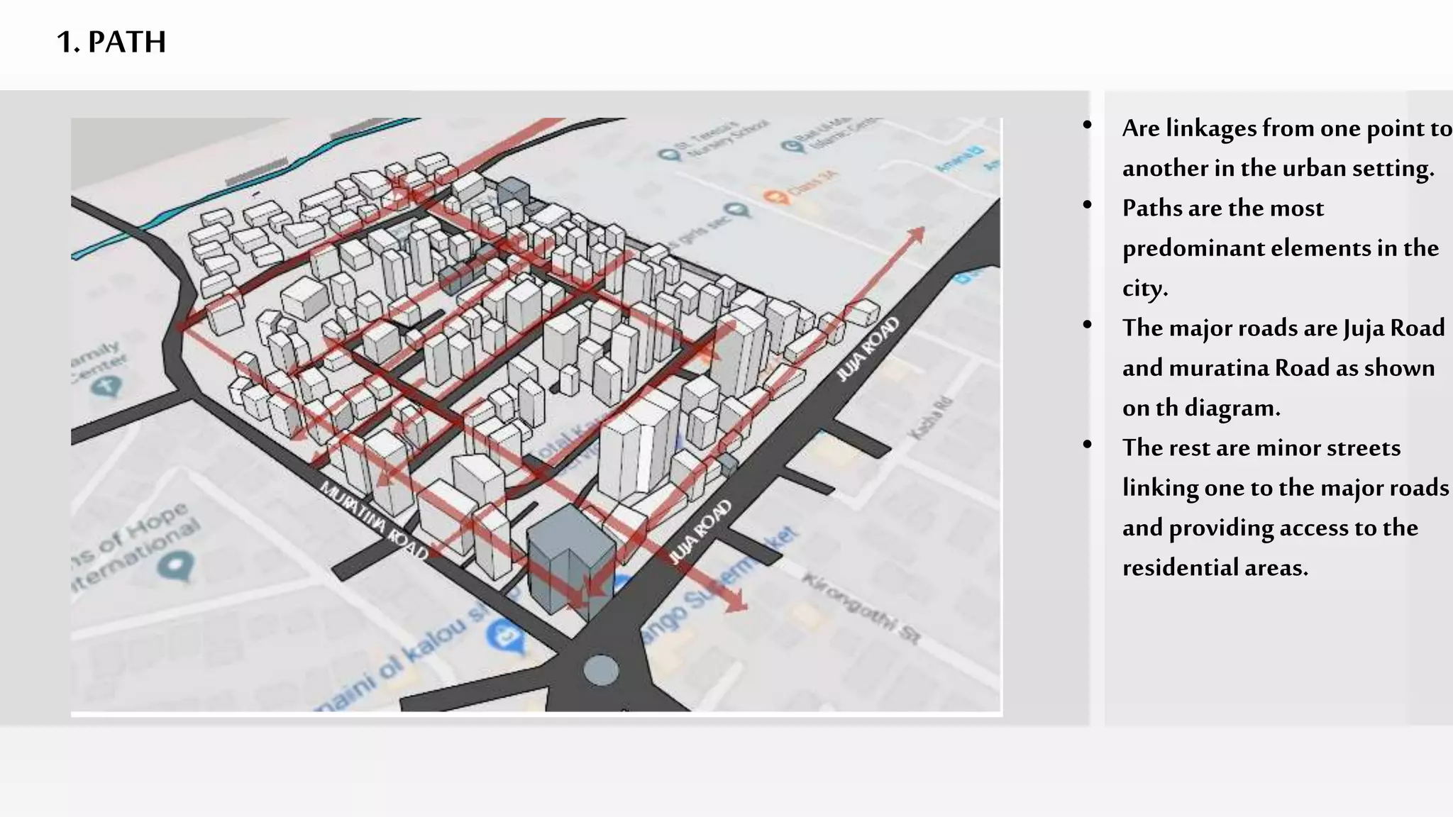
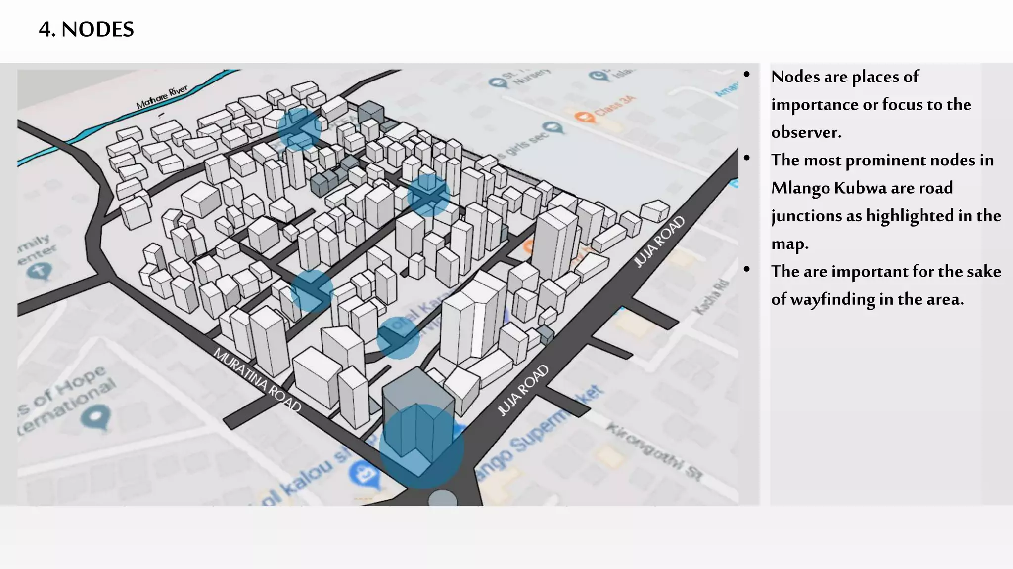
URBAN DESIGN; MLANGO KUBWA
With referenceto Kevin Lynch’sImage of theCity
GROUP11
BY:
SYLVIA OLUNGA
MELANIE GITHIORI
ELEMENTS OF URBAN DESIGN
1. Paths
These are channels along which the observermoves.
Paths are the most predominant elements of urban design.
Characteristics
• Identity – defined by façade characteristics
• Continuity – character and activity
• Sense of direction
• Gradient – topographic and use intensity gradient
• Street Pattern
2. Edge
• Edges are boundaries betweentwo phases.
• Theyservethe purposeof holding together generalized areas.
• Edges could be ; I) paths
ii) walls
iii) shores
• Edges divide as well as unite spaces.
• Edges have directional qualities.
3. Districts
• Districts are large city areas which bear a common character.
• Districts are defined by thematic continuities or components which
include; activities, topography, degreeof maintenance, building
typologies, spaces and textures.
• Districts are defined by boundaries which can either be;- definite and
precise
- soft and uncertain
4. Nodes
• These are strategic places of importance to the observer.
• These are decision – making points.
• Nodesinclude; - junctions
-break in transportation
-crossing or convergence of path
-moments of shift from one structure
to another.
5. Landmarks
• Landmarks are external points of referenceto the observer.
• They are majorly physical elements.
• An element is considered as a landmark if;
-it has a clear form
- it contrasts with its background
- it has prominence in its spatial location.
• Examples of landmarks include; buildings, mountains, rivers, signs etc.
LEGEND
PATH
EDGE
DISTRICT
NODE
LANDMARK
ElementsofUrbanDesigninMlangoKubwa
1. PATH
• Are linkagesfrom one point to
another in the urban setting.
• Pathsare the most
predominant elementsin the
city.
• The majorroads are Juja Road
and muratina Road as shown
onth diagram.
• The rest are minor streets
linkingone to the majorroads
and providing access tothe
residentialareas.
StreetConfiguration
• The Street pattern in Mlango
Kubwa area is notwell
defined.
• However, the paths try to form
a grid pattern.
• There is a sense of continuity
and direction along Juja and
Muratina road.
• Within the settlements, the
paths tend change directions
abruptly hence its easy for on
toget lost within the area.
• View of Juja Road
• View of Muratina Road
Majorroadsonsite
• Juja road is the busiest road on
site.
• Bothroads are poorly
maintainedwith nos side
walks and street vendors
takingup all the space for
business activities.
• Commercial activitieson
streets intensifiesas one goes
deeper into site.
MinorStreetsonsite
• The minor streets are
narrower and some have dead
ends thuspose a challenge on
clear circulation around site.
`
2. EDGE
• Edges are boundaries between
2 phases.
• They serve tobound elements
within and define itas one.
• Edges serve the function of
both unitingand dividing.
• The edges should enhance
visibilityand continuity.
• In our case, MlangoKubwa is
bound by road channels,
Mathare River and boundary
wall.
NorthernEdge
• Northern edge of siteis
defined by Mathare river
which is poorly maintained
and is a dumping sit for
sewage.
EasternEdge
• Eastern edge of site is defined
by a boundary wall dividing
the sit from st. Theresas High
School.
• There is also trees which adorn
this edge apart from the wall.
SouthernEdge
• The southern edge, which is
the street frontage is defined
by Juja road, which is also an
administrativeboundary,
dividingMathare from
eastleigh.
WesternEdge
• The western edge is defined by
Muratina Road, which
connects toThika Super
Highway.
• The road is totally dominated
by hawkers.
WesternEdge
3. DISTRICTS
• Districts are places of internal
consistences in the city.
• These places have common
thematic continuities which
define them.
• According tothe definition,
MlangoKubwa canbe
identified to have two districts
with regards to building
typologies.
• One consists of mostly high
rise type while the other
shanties.
A
B
• District A
• Mostly comprised of shanties,
made of mabati.
• District B
• Mostly made of high rise
structures constructed using
masonry.
• District classificationis in
accordance with dominant
buildingtypologies and the
state of maintenance of
structures.
Districts
4. NODES
• Nodes are places of
importance or focus tothe
observer.
• The mostprominentnodes in
Mlango Kubwa are road
junctions as highlighted inthe
map.
• The are importantfor the sake
of wayfinding in the area.
Nodes
The roundabout is
an important
Nodein
Mlango Kubwa.
Junction along
Muratina Road
Leading to
Mlango Kubwa
5. LANDMARKS
• Landmarks are externalpoints
of reference tothe observer.
• Thy are mostlyphysical
elments.
• In Mlango Kubwa, Mathare
River acts as a landmark as
well as an edge in th area.
• From the river, one caneasily
trace their way toand from th
site.
• The topography of the area
slopes towards the river.
• Mathare river defines the
lowest point of Mlango
Kubwa.
• In wayfinding, one may walk
along the rivertoget to
Muratina road or upslope to
get to Juja road.
• Thus, topography also
enhances the rivr as a
landmark.
THE END.

Urban design

  • 1.
    URBAN DESIGN; MLANGOKUBWA With referenceto Kevin Lynch’sImage of theCity GROUP11 BY: SYLVIA OLUNGA MELANIE GITHIORI
  • 2.
    ELEMENTS OF URBANDESIGN 1. Paths These are channels along which the observermoves. Paths are the most predominant elements of urban design. Characteristics • Identity – defined by façade characteristics • Continuity – character and activity • Sense of direction • Gradient – topographic and use intensity gradient • Street Pattern
  • 3.
    2. Edge • Edgesare boundaries betweentwo phases. • Theyservethe purposeof holding together generalized areas. • Edges could be ; I) paths ii) walls iii) shores • Edges divide as well as unite spaces. • Edges have directional qualities.
  • 4.
    3. Districts • Districtsare large city areas which bear a common character. • Districts are defined by thematic continuities or components which include; activities, topography, degreeof maintenance, building typologies, spaces and textures. • Districts are defined by boundaries which can either be;- definite and precise - soft and uncertain
  • 5.
    4. Nodes • Theseare strategic places of importance to the observer. • These are decision – making points. • Nodesinclude; - junctions -break in transportation -crossing or convergence of path -moments of shift from one structure to another.
  • 6.
    5. Landmarks • Landmarksare external points of referenceto the observer. • They are majorly physical elements. • An element is considered as a landmark if; -it has a clear form - it contrasts with its background - it has prominence in its spatial location. • Examples of landmarks include; buildings, mountains, rivers, signs etc.
  • 7.
  • 8.
    1. PATH • Arelinkagesfrom one point to another in the urban setting. • Pathsare the most predominant elementsin the city. • The majorroads are Juja Road and muratina Road as shown onth diagram. • The rest are minor streets linkingone to the majorroads and providing access tothe residentialareas.
  • 9.
    StreetConfiguration • The Streetpattern in Mlango Kubwa area is notwell defined. • However, the paths try to form a grid pattern. • There is a sense of continuity and direction along Juja and Muratina road. • Within the settlements, the paths tend change directions abruptly hence its easy for on toget lost within the area.
  • 10.
    • View ofJuja Road • View of Muratina Road Majorroadsonsite • Juja road is the busiest road on site. • Bothroads are poorly maintainedwith nos side walks and street vendors takingup all the space for business activities. • Commercial activitieson streets intensifiesas one goes deeper into site.
  • 11.
    MinorStreetsonsite • The minorstreets are narrower and some have dead ends thuspose a challenge on clear circulation around site.
  • 12.
    ` 2. EDGE • Edgesare boundaries between 2 phases. • They serve tobound elements within and define itas one. • Edges serve the function of both unitingand dividing. • The edges should enhance visibilityand continuity. • In our case, MlangoKubwa is bound by road channels, Mathare River and boundary wall.
  • 13.
    NorthernEdge • Northern edgeof siteis defined by Mathare river which is poorly maintained and is a dumping sit for sewage.
  • 14.
    EasternEdge • Eastern edgeof site is defined by a boundary wall dividing the sit from st. Theresas High School. • There is also trees which adorn this edge apart from the wall.
  • 15.
    SouthernEdge • The southernedge, which is the street frontage is defined by Juja road, which is also an administrativeboundary, dividingMathare from eastleigh.
  • 16.
    WesternEdge • The westernedge is defined by Muratina Road, which connects toThika Super Highway. • The road is totally dominated by hawkers. WesternEdge
  • 17.
    3. DISTRICTS • Districtsare places of internal consistences in the city. • These places have common thematic continuities which define them. • According tothe definition, MlangoKubwa canbe identified to have two districts with regards to building typologies. • One consists of mostly high rise type while the other shanties. A B
  • 18.
    • District A •Mostly comprised of shanties, made of mabati. • District B • Mostly made of high rise structures constructed using masonry. • District classificationis in accordance with dominant buildingtypologies and the state of maintenance of structures. Districts
  • 19.
    4. NODES • Nodesare places of importance or focus tothe observer. • The mostprominentnodes in Mlango Kubwa are road junctions as highlighted inthe map. • The are importantfor the sake of wayfinding in the area.
  • 20.
    Nodes The roundabout is animportant Nodein Mlango Kubwa.
  • 21.
  • 22.
    5. LANDMARKS • Landmarksare externalpoints of reference tothe observer. • Thy are mostlyphysical elments. • In Mlango Kubwa, Mathare River acts as a landmark as well as an edge in th area. • From the river, one caneasily trace their way toand from th site. • The topography of the area slopes towards the river.
  • 23.
    • Mathare riverdefines the lowest point of Mlango Kubwa. • In wayfinding, one may walk along the rivertoget to Muratina road or upslope to get to Juja road. • Thus, topography also enhances the rivr as a landmark.
  • 24.