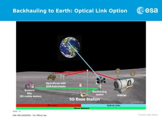
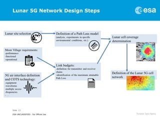
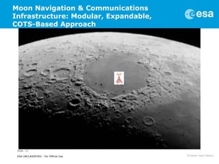
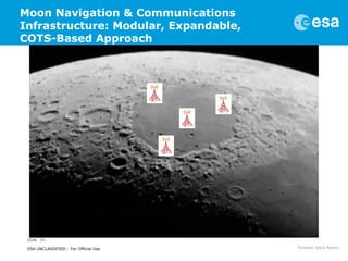
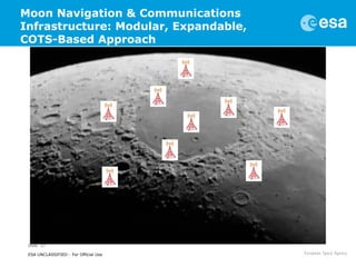
This document discusses proposals for establishing a communications and navigation network to support human and robotic exploration of the Moon. It summarizes past ESA studies on using GPS and developing lunar navigation and communication satellites. It then proposes a modular, expandable approach using commercial off-the-shelf (COTS) technologies like LTE and the forthcoming 5G standard. This COTS-based lunar network would provide reliable communication and navigation services to support colonization of the Moon and Mars through permanent base stations. It would satisfy requirements for performance, reliability, affordability and sustainability by leveraging commercial technologies and allowing incremental expansion over time.
A CubeSat (U-class spacecraft) is a type of miniaturized satellite for space research that is made up of multiples of 10×10×10 cm cubic units. CubeSats have a mass of no more than 1.33 kilograms per unit.
Mercury CubeSat Presentation for ASAT2016Karen Grothe
An abridged version of my Capstone project for my Systems Engineering Masters Degree program. Presented at AIAA OC ASAT in April 2016. (Virtually the same as my INCOSE RMC presentation.)
Galileo is the European GNSS constellation and it contributes to the user positioning adding more satellites, which number directly impacts on the Dilution of precision (DOP), or geometric dilution of precision (GDOP). It is a term used in satellite navigation and geomatics engineering to specify the additional multiplicative effect of navigation satellite geometry on positional measurement precision.
A ppt to present small satellite like microsat,nanosat(JUGNU by IIT Kanpur) and Picosat.
in short i like to say Small satellite is that which weighs below 100 kg........for more pls read slides.
Satellite navigation and and how it works wonderdome
“You have reached your destination!” Many of us hear these words if not on a daily basis. Honestly, I don’t even want to look back at the times before the satellite navigation. Those were the times of hand-drawn maps, road atlases and being lost. A lot. Now everybody has a satnav device for their personal use. What’s even more important, trains, ships, planes and even robots use the satellite navigation too!
But how does the technology actually work?
The idea is beautifully simple:
Get a radio signal from a satellite on your receiver. The signal can include the time when it was sent and the location of the satellite. When you receive the signal, the distance to the satellite can be easily calculated as you will know how long it took for the signal to arrive to the receiver (and we know how fast the signal travels, right?). The distance to the satellite will give you the area of your possible locations. Not yet good enough! To narrow down your location area take the second satellite and repeat the process. And finally add the third satellite. Here you are!
With just 3 satellites you will know your position on the “mean sea level”. But at least 4 satellites are needed to determine your accurate location if you are up in the mountains. In practice, 6 satellites are usually visible from each location.
When a geosynchronous satellite is placed directly above the Equator with a circular orbit and angular velocity identical to that of the Earth, the satellite is known as a geostationary satellite.
Satellite communication (simple self-explanatory ppt)DurgaSrinivas5
I choose to explain the most complex topic - satellite communication in the easiest and simplest way possible to our classmates in an internship review, that I've done.
This Powerpoint(ppt) has simple text and images where we need to explain the pictures ourselves and even included a motion video/GIF for a good presentation.
2017 Ka-band and AIAA ICSSC Joint Conference -TriesteMarco Lisi
2017 Joint Conference
Commercial Space Applications:
Transformation, Fusion and Competition
Trieste, Italy • Excelsior Palace Hotel • October 17-19, 2017
How ubiquitous localization (GNSS), sensing (IoT) and communications (5G) are mapping our planet.
Presentation at the Aerospace & Defense Forum 2016, 14 June, Reading, UK.
My short course on the TICE methodology at the Master in Satellites and Orbiting Platforms, University of Rome, "La Spaienza", 31 March - 1 April 2016.
"Key infrastructure technologies for sustained human exploration of the Moon ...Marco Lisi
My presentation "Key infrastructure technologies for sustained human exploration of the Moon and Mars"at the workshop Space Horizons 2015, "McMurco on the Moon", February 18-19, 2015, Brown University
International Journal of Engineering and Science Invention (IJESI) is an international journal intended for professionals and researchers in all fields of computer science and electronics. IJESI publishes research articles and reviews within the whole field Engineering Science and Technology, new teaching methods, assessment, validation and the impact of new technologies and it will continue to provide information on the latest trends and developments in this ever-expanding subject. The publications of papers are selected through double peer reviewed to ensure originality, relevance, and readability. The articles published in our journal can be accessed online.
Flying to Jupiter with OSGi - Tony Walsh (ESA) & Hristo Indzhov (Telespazio V...mfrancis
OSGi Community Event 2018 Presentation by Tony Walsh (ESA) & Hristo Indzhov (Telespazio Vega)
Abstract: The European Space Operations Centre (ESOC) is the main operations center for the European Space Agency (ESA), operating a number of earth observation and scientific missions. Monitoring and control functions needed by spacecraft operators are provided by software systems which are reused across missions, but tailored and extended for mission specific needs. The current generation of monitoring and control systems are becoming obsolete and a European wide initiative called the European Ground Systems Common Core (EGS-CC) (http://www.egscc.esa.int) has been started to develop the next generation.
This talk will explain why OSGi was chosen and how it is used in the development of next generation of monitoring and control software. It will describe how OSGi provides the necessary framework that enables the software to be extended for the different space systems it is expected to support. The overall software architecture will be discussed, some of the challenges faced and the benefits gained by using OSGi. The first target mission for the system is JUICE (http://sci.esa.int/juice) which will explore the moons of Jupiter and which is scheduled for launch in 2022.
THEOS (Thailand Earth Observation System)
THEOS is an Earth observation mission of Thailand, under development at EADS Astrium SAS, Toulouse, France. In July 2004, EADS Astrium SAS signed a contract for delivery of THEOS with GISTDA (Geo-Informatics and Space Technology Development Agency) of Bangkok, Thailand. GISTDA is Thailand's leading national organization (i.e., space agency) in the field of space activities and applications. The Thai Ministry of Science and Technology is funding the program.
The THEOS cooperative agreement includes the production and launch of one optical imaging satellite, as well as the development of the ground segment necessary to operate and control the satellite directly from Thailand. The contract also specifies on-the-job training of Thai engineers as part of the EADS Astrium development team. Also as part of the THEOS program, GISTDA earned the right to receive data from the SPOT-2, 4 and 5 spacecraft of CNES in Thailand, which have many features similar to those of THEOS. The prime objective of THEOS is to provide Thailand with an affordable access to space (i.e., a state-of-the-art Earth observation satellite for the near future), and to spawn through this program's operational experience the country's own capability and infrastructure an indigenous potential for the development of future space missions.
The science objectives call for the provision of:
1) Panchromatic (2 m) and multispectral (15 m) imagery from THEOS observations, and
2) The generation of geo-referenced image products and image processing capabilities for applications in the fields of cartography, land use, agricultural monitoring, forestry management, coastal zone monitoring and flood risk management.
The Thai government has also expressed its intention to offer THEOS data to the disaster mitigation efforts under the International Charter.
Locata with Femtocell: Secure Dual Connectivity in Areas with Medium to Weak ...Eswar Publications
The Global Positioning System (GPS) is a reliable, versatile, generally available and comparatively accurate positioning technology, able to operate anywhere across the globe. Nevertheless, the most severe limitation of GPS performance will still remain – the accuracy of positioning deteriorates very rapidly when the user receiver loses direct view of the satellites, which typically occurs indoors or in severely obstructed urban environments. In such environments, the majority of receivers do not function at all, and even the high-sensitivity receivers have difficulty in providing coordinates with sub-decameter level accuracies. A new terrestrial radio frequency (RF)- based distance measurement technology, known as ‘Locata’, has now overcome the technical challenges required to create “a localized autonomous terrestrial replica of GPS”. This paper describes some of the technical aspects
of this Australian technology and discusses the possible role Locata can play as part of the National Positioning Infrastructure. Locata has developed a new type of antenna which allows industrial-grade, centimeter-level positioning indoors by mitigating multipath by forming and pointing tight beams at the Locata transmitters, significantly reducing the effects of multipath corruption of the direct positioning signal. This paper briefly describes Locata tests conducted in a number of conditions, including indoors, at an open-cut mine, airborne flight testing, and on Sydney Harbour. A new system can be proposed that will be composed of locata along with
femtocell to provide users both GPS and GSM services.
Presentation of my paper "Performance Specification of Active Antenna Systems" at the 39th ESA Antenna Workshop, 2-4 October 2018, ESA-ESTEC, The Netherlands
My keynote presentation on "Integration and Fusion of PNT, Remote Sensing and Telecommunications Infrastructures" at the International Symposium on Networks, Computers and Communications, Rome, 19 June 2018.
"Integration and Fusion of Space and Ground Technologies and Infrastructures"Marco Lisi
My presentation at the joint 23rd Ka and Broadband Communications Conference and 35th AIAA International Communications Satellite Systems Conference (ICSSC) in Trieste, Italy, October 16 -19 2017.
"Initial Services: la nuova fase del programma Galileo", article in Italian published on Geomedia.
"Il 15 dicembre dello scorso anno, nel corso di una cerimonia alla quale hanno partecipato tutti i principali personaggi del programma Galileo a livello istituzionale (la Commissaria Bienkovska ed il Commissario Sefcovich per la Commissione Europea, il Direttore Generale prof. Woerner ed il Direttore dei Programmi di Navigazione Paul Verhoef per l’ESA, il Direttore Esecutivo Carlo Des Dorides per la GSA), sono stati dichiarati
ufficialmente operativi i “Galileo Initial Services”.
Economia dei servizi: una visione sistemicaMarco Lisi
Economia dei servizi: Una visione sistemica
Per far sì che un sistema tecnologico divenga un ‘sistema di servizio’, che abbia cioè al centro la customer satisfaction, è necessario che all’infrastruttura tecnologica si aggiungano in una configurazione dinamica risorse umane, organizzazione e informazione condivisa.
Second lesson of my introduction to antennas for space applications - Space Challenges - Sofia 2015
Topics: satellite orbits, global coverage, spot beams, multi-beam coverage, contoured coverage, reflector antennas, parabolic reflectors, phased-array antennas.
A responsive satellite-industry_ka2015_lisi_v02Marco Lisi
Presentation of my paper "A Responsive Satellite Industry for Responsive and Timely Delivered Satellite Systems" at the 21st Ka and Broadband Communications Conference in Bologna, 12-14 October 2015.
Builder.ai Founder Sachin Dev Duggal's Strategic Approach to Create an Innova...Ramesh Iyer
In today's fast-changing business world, Companies that adapt and embrace new ideas often need help to keep up with the competition. However, fostering a culture of innovation takes much work. It takes vision, leadership and willingness to take risks in the right proportion. Sachin Dev Duggal, co-founder of Builder.ai, has perfected the art of this balance, creating a company culture where creativity and growth are nurtured at each stage.
Dev Dives: Train smarter, not harder – active learning and UiPath LLMs for do...UiPathCommunity
💥 Speed, accuracy, and scaling – discover the superpowers of GenAI in action with UiPath Document Understanding and Communications Mining™:
See how to accelerate model training and optimize model performance with active learning
Learn about the latest enhancements to out-of-the-box document processing – with little to no training required
Get an exclusive demo of the new family of UiPath LLMs – GenAI models specialized for processing different types of documents and messages
This is a hands-on session specifically designed for automation developers and AI enthusiasts seeking to enhance their knowledge in leveraging the latest intelligent document processing capabilities offered by UiPath.
Speakers:
👨🏫 Andras Palfi, Senior Product Manager, UiPath
👩🏫 Lenka Dulovicova, Product Program Manager, UiPath
PHP Frameworks: I want to break free (IPC Berlin 2024)Ralf Eggert
In this presentation, we examine the challenges and limitations of relying too heavily on PHP frameworks in web development. We discuss the history of PHP and its frameworks to understand how this dependence has evolved. The focus will be on providing concrete tips and strategies to reduce reliance on these frameworks, based on real-world examples and practical considerations. The goal is to equip developers with the skills and knowledge to create more flexible and future-proof web applications. We'll explore the importance of maintaining autonomy in a rapidly changing tech landscape and how to make informed decisions in PHP development.
This talk is aimed at encouraging a more independent approach to using PHP frameworks, moving towards a more flexible and future-proof approach to PHP development.
JMeter webinar - integration with InfluxDB and GrafanaRTTS
Watch this recorded webinar about real-time monitoring of application performance. See how to integrate Apache JMeter, the open-source leader in performance testing, with InfluxDB, the open-source time-series database, and Grafana, the open-source analytics and visualization application.
In this webinar, we will review the benefits of leveraging InfluxDB and Grafana when executing load tests and demonstrate how these tools are used to visualize performance metrics.
Length: 30 minutes
Session Overview
-------------------------------------------
During this webinar, we will cover the following topics while demonstrating the integrations of JMeter, InfluxDB and Grafana:
- What out-of-the-box solutions are available for real-time monitoring JMeter tests?
- What are the benefits of integrating InfluxDB and Grafana into the load testing stack?
- Which features are provided by Grafana?
- Demonstration of InfluxDB and Grafana using a practice web application
To view the webinar recording, go to:
https://www.rttsweb.com/jmeter-integration-webinar
Key Trends Shaping the Future of Infrastructure.pdfCheryl Hung
Keynote at DIGIT West Expo, Glasgow on 29 May 2024.
Cheryl Hung, ochery.com
Sr Director, Infrastructure Ecosystem, Arm.
The key trends across hardware, cloud and open-source; exploring how these areas are likely to mature and develop over the short and long-term, and then considering how organisations can position themselves to adapt and thrive.
LF Energy Webinar: Electrical Grid Modelling and Simulation Through PowSyBl -...DanBrown980551
Do you want to learn how to model and simulate an electrical network from scratch in under an hour?
Then welcome to this PowSyBl workshop, hosted by Rte, the French Transmission System Operator (TSO)!
During the webinar, you will discover the PowSyBl ecosystem as well as handle and study an electrical network through an interactive Python notebook.
PowSyBl is an open source project hosted by LF Energy, which offers a comprehensive set of features for electrical grid modelling and simulation. Among other advanced features, PowSyBl provides:
- A fully editable and extendable library for grid component modelling;
- Visualization tools to display your network;
- Grid simulation tools, such as power flows, security analyses (with or without remedial actions) and sensitivity analyses;
The framework is mostly written in Java, with a Python binding so that Python developers can access PowSyBl functionalities as well.
What you will learn during the webinar:
- For beginners: discover PowSyBl's functionalities through a quick general presentation and the notebook, without needing any expert coding skills;
- For advanced developers: master the skills to efficiently apply PowSyBl functionalities to your real-world scenarios.
Kubernetes & AI - Beauty and the Beast !?! @KCD Istanbul 2024Tobias Schneck
As AI technology is pushing into IT I was wondering myself, as an “infrastructure container kubernetes guy”, how get this fancy AI technology get managed from an infrastructure operational view? Is it possible to apply our lovely cloud native principals as well? What benefit’s both technologies could bring to each other?
Let me take this questions and provide you a short journey through existing deployment models and use cases for AI software. On practical examples, we discuss what cloud/on-premise strategy we may need for applying it to our own infrastructure to get it to work from an enterprise perspective. I want to give an overview about infrastructure requirements and technologies, what could be beneficial or limiting your AI use cases in an enterprise environment. An interactive Demo will give you some insides, what approaches I got already working for real.
UiPath Test Automation using UiPath Test Suite series, part 3DianaGray10
Welcome to UiPath Test Automation using UiPath Test Suite series part 3. In this session, we will cover desktop automation along with UI automation.
Topics covered:
UI automation Introduction,
UI automation Sample
Desktop automation flow
Pradeep Chinnala, Senior Consultant Automation Developer @WonderBotz and UiPath MVP
Deepak Rai, Automation Practice Lead, Boundaryless Group and UiPath MVP
Software Delivery At the Speed of AI: Inflectra Invests In AI-Powered QualityInflectra
In this insightful webinar, Inflectra explores how artificial intelligence (AI) is transforming software development and testing. Discover how AI-powered tools are revolutionizing every stage of the software development lifecycle (SDLC), from design and prototyping to testing, deployment, and monitoring.
Learn about:
• The Future of Testing: How AI is shifting testing towards verification, analysis, and higher-level skills, while reducing repetitive tasks.
• Test Automation: How AI-powered test case generation, optimization, and self-healing tests are making testing more efficient and effective.
• Visual Testing: Explore the emerging capabilities of AI in visual testing and how it's set to revolutionize UI verification.
• Inflectra's AI Solutions: See demonstrations of Inflectra's cutting-edge AI tools like the ChatGPT plugin and Azure Open AI platform, designed to streamline your testing process.
Whether you're a developer, tester, or QA professional, this webinar will give you valuable insights into how AI is shaping the future of software delivery.
Search and Society: Reimagining Information Access for Radical FuturesBhaskar Mitra
The field of Information retrieval (IR) is currently undergoing a transformative shift, at least partly due to the emerging applications of generative AI to information access. In this talk, we will deliberate on the sociotechnical implications of generative AI for information access. We will argue that there is both a critical necessity and an exciting opportunity for the IR community to re-center our research agendas on societal needs while dismantling the artificial separation between the work on fairness, accountability, transparency, and ethics in IR and the rest of IR research. Instead of adopting a reactionary strategy of trying to mitigate potential social harms from emerging technologies, the community should aim to proactively set the research agenda for the kinds of systems we should build inspired by diverse explicitly stated sociotechnical imaginaries. The sociotechnical imaginaries that underpin the design and development of information access technologies needs to be explicitly articulated, and we need to develop theories of change in context of these diverse perspectives. Our guiding future imaginaries must be informed by other academic fields, such as democratic theory and critical theory, and should be co-developed with social science scholars, legal scholars, civil rights and social justice activists, and artists, among others.
Search and Society: Reimagining Information Access for Radical Futures
A COMMUNICATIONS AND PNT INTEGRATED NETWORK INFRASTRUCTURE FOR THE MOON VILLAGE
1. ESA UNCLASSIFIED - For Official Use
A COMMUNICATIONS AND PNT
INTEGRATED NETWORK
INFRASTRUCTURE
FOR THE MOON VILLAGE
Pietro Giordano(1), Marco Lisi(1), Andrea Modenini(1),
José A. del Peral-Rosado(2)
(1)European Space Agency - European Space Research Technology Centre (ESTEC)
(2) Universitat Autònoma de Barcelona (UAB)
NAVITEC workshop 2016, ESTEC, 16/12/2016
2. Slide 2
ESA UNCLASSIFIED - For Official Use
Summary
• The exploration of Moon and Mars with human and robotic
missions and their colonization, through the establishment of
permanent bases, will require planetary communications and
navigation infrastructures;
• All architectural approaches considered so far by NASA and ESA
can be divided in two main categories:
Comprehensive, well structured and forward looking (but
costly) architectures, based on constellations of orbiters and
relay satellites
“ad hoc”, flexible, expandable architectures, based on a fusion
of all available resources and on COTS technologies
4. Slide 4
ESA UNCLASSIFIED - For Official Use
Moon Village
“Moon Village is not a single
project, nor a fixed plan with a
defined time table. It’s a vision for
an open architecture and an
international community
initiative.”
From the ESA Ministerial Council 2016 minisite
5. Slide 5
ESA UNCLASSIFIED - For Official Use
GNSS Beyond Earth Orbit
• GPS signals effective up to the Earth-Moon 1st Lagrange Point
(L1)
322,000 km from Earth
Approximately 4/5 the distance to the Moon
• GPS signals can be tracked to the surface of the Moon, but
usable with advanced GPS receiver technology
6. Slide 6
ESA UNCLASSIFIED - For Official Use
Past ESA Activities: PLANCOM (1/2)
• PLANCOM: ESA Feasibility Study for a Reduced Planetary
Navigation & Communication System
• Planetary infrastructure for future robotic and manned missions
on Moon or Mars;
• Communication and navigation network using an integrated
signal to provide in-situ services, such as high-quality video,
audio channels, data network, biomedical data;
• Orthogonal Frequency-Division Multiple Access (OFDMA) signal
based on the IEEE 802.16 WiMAX standard;
• Navigation capabilities integrated in the waveform, allowing
Time of Arrival (TOA) relative real-time positioning over the
planetary surface;
• Non real-time fine positioning using available orbiters, possibly
using Earth GNSS signals as additional ranging observables.
8. Slide 8
ESA UNCLASSIFIED - For Official Use
Past ESA Activities: PLANCOM (2/2)
“In the timeframe considered by
this study it is possible that
WiMAX will have been
replaced by other
technologies offering similar
capabilities.”
9. Slide 9
ESA UNCLASSIFIED - For Official Use
Past ESA Activities: Moon-GNSS (1/2)
• MOON-GNSS: ESA Study about Use of Weak-Signals GNSS
Navigation;
• Objective: to assess the feasibility of using weak-signal GNSS
(GPS/Galileo) technology in future lunar missions, to assist
Lunar Transfer Orbit (LTO), Low Lunar Orbit (LLO), Descent and
Landing, and operations at landing site.
10. Slide 10
ESA UNCLASSIFIED - For Official Use
Past ESA Activities: Moon-GNSS (2/2)
• EGNSS: Earth GNSS constellations (GPS/Galileo)
• MGNSS: GNSS satellite orbiting around the Moon
• MSB: Moon Surface Beacon
15. Slide 15
ESA UNCLASSIFIED - For Official Use
Moon Navigation & Communications
Infrastructure: Modular, Expandable,
COTS-Based Approach
16. Slide 16
ESA UNCLASSIFIED - For Official Use
Moon Navigation & Communications
Infrastructure: Modular, Expandable,
COTS-Based Approach
17. Slide 17
ESA UNCLASSIFIED - For Official Use
Moon Navigation & Communications
Infrastructure: Modular, Expandable,
COTS-Based Approach
18. Slide 18
ESA UNCLASSIFIED - For Official Use
Conclusion
• The colonization of our solar system, first step of human kind
towards the stars, will need establishing permanent base
stations on Moon and Mars;
• Planetary infrastructures will provide communications and
navigation support to both human and robotic explorers;
• The approach presented relies on the use of COTS components
for communication and navigation on the Moon surface;
• The use of LTE technology, currently deployed on Earth, and of
the forthcoming 5G technology will allow communication and
navigation on the Moon, largely satisfying the requirements for
performance, reliability, affordability and sustainability (being
based on commercial technology and incrementally expandable
over time).