SlideShare a Scribd company logo
Frank Martin Seifert | 06/10/2016 | Slide 1ESA UNCLASSIFIED - For Official Use
Mapping Peatlands in Sweden:
Store Mosse-Kävsjön
1
Sentinel-2 2015-08-
19
Sentinel-1 (VV) 2014-
2016
http://swos-service.eu
ESA UNCLASSIFIED - For Official Use
A New Generation of Data Sources
08/2005 - 2
Sent-1A/B Sent-2A/B Sent-3A/B Sent-5/5P Sent-6/Jason-CSSent-4A/B
 Copernicus is a European space flagship programme led
by the European Union
 ESA coordinates the space component
 Copernicus provides the necessary data for operational
monitoring of the environment and for civil security
 Data policy: free and open access
 https://scihub.copernicus.eu/
ESA UNCLASSIFIED - For Official Use
… for today and for the future
S1: Radar Mission
S2: High Resolution Optical Mission
S3: Medium Resolution Imaging and Altimetry Mission
S4: Geostationary Atmospheric Chemistry Mission
S5P: Low Earth Orbit Atmospheric Chemistry Precursor Mission
S5: Low Earth Orbit Atmospheric Chemistry Mission
S6 (Jason-CS): Altimetry Mission
Frank Martin Seifert | 06/10/2016 | Slide 4ESA UNCLASSIFIED - For Official Use
Sentinel-1 and Sentinel-2
Sentinel-2A / -2B
• multispectral (13 bands)
• 10 days repeat cycle
(5 days with 2 satellites)
• 290 km swath width
 http://sentinel.esa.int/
Sentinel-1A / -1B
• night and day radar
imaging
• C-band SAR
• 12 days repeat cycle
(6 days with 2 satellites)
Frank Martin Seifert | 06/10/2016 | Slide 5ESA UNCLASSIFIED - For Official Use
Congo Basin Short term changes
5
Frank Martin Seifert | 06/10/2016 | Slide 6ESA UNCLASSIFIED - For Official Use
Congo Basin Short term changes
6
ESA UNCLASSIFIED - For Official Use
Summary
• The European Copernicus Programme will secure continuity
of observations and data availability for the next 20+
years with free and open access for everybody
 https://scihub.copernicus.eu/
• The Sentinels will be major workhorses for REDD+ and
have a great potential for peatland mapping and
monitoring;
• ESA will support the Global Peatland Initiative with a
dedicated project developing and demonstrating
methodologies for peatland mapping and monitoring defined
in dialogue with the GPI partners and users world-wide.
ESA UNCLASSIFIED - For Official Use

More Related Content

What's hot

Geospatial intelligence satellite applications catapult pdf - july 23 2019
Geospatial intelligence   satellite applications catapult pdf - july 23 2019Geospatial intelligence   satellite applications catapult pdf - july 23 2019
Geospatial intelligence satellite applications catapult pdf - july 23 2019
Peter Bloomfield
 
Real-Time Satellite Tracking and Orbit Prediction with GPREDICT
Real-Time Satellite Tracking and Orbit Prediction with GPREDICTReal-Time Satellite Tracking and Orbit Prediction with GPREDICT
Real-Time Satellite Tracking and Orbit Prediction with GPREDICT
Alexandru Csete
 
GEM’s hazard products: outcomes and applications
GEM’s hazard products: outcomes and applicationsGEM’s hazard products: outcomes and applications
GEM’s hazard products: outcomes and applications
Global Earthquake Model Foundation
 
The Seismic Hazard Modeller’s Toolkit: An Open-Source Library for the Const...
The Seismic Hazard Modeller’s Toolkit:  An Open-Source Library for the Const...The Seismic Hazard Modeller’s Toolkit:  An Open-Source Library for the Const...
The Seismic Hazard Modeller’s Toolkit: An Open-Source Library for the Const...
Global Earthquake Model Foundation
 
PERICLES Preserving space data
PERICLES Preserving space dataPERICLES Preserving space data
PERICLES Preserving space data
PERICLES_FP7
 
Orolia EU Space Week 2018 - Maritime session
Orolia EU Space Week 2018 - Maritime sessionOrolia EU Space Week 2018 - Maritime session
Orolia EU Space Week 2018 - Maritime session
The European GNSS Agency (GSA)
 
Position Navigation and Timing Applications | Chaz Dixon | March 2015
Position Navigation and Timing Applications | Chaz Dixon | March 2015Position Navigation and Timing Applications | Chaz Dixon | March 2015
Position Navigation and Timing Applications | Chaz Dixon | March 2015
Department for Communities and Local Government Local Digital Campaign
 
Visualization of Marine Sand Dune Displacements utilizing Modern GPU Techniqu...
Visualization of Marine Sand Dune Displacements utilizing Modern GPU Techniqu...Visualization of Marine Sand Dune Displacements utilizing Modern GPU Techniqu...
Visualization of Marine Sand Dune Displacements utilizing Modern GPU Techniqu...
GeoVIS'15 Workshop
 
A new generation of data to monitor landscapes across the tropics
A new generation of data to monitor landscapes across the tropicsA new generation of data to monitor landscapes across the tropics
A new generation of data to monitor landscapes across the tropics
CIFOR-ICRAF
 
Atmos - Tom hartley - Modelling Bird Behaviour to Progress Wind Farm Development
Atmos - Tom hartley - Modelling Bird Behaviour to Progress Wind Farm DevelopmentAtmos - Tom hartley - Modelling Bird Behaviour to Progress Wind Farm Development
Atmos - Tom hartley - Modelling Bird Behaviour to Progress Wind Farm Development
Esri UK
 
Introdution to Landsat and Google Earth Engine
Introdution to Landsat and Google Earth EngineIntrodution to Landsat and Google Earth Engine
Introdution to Landsat and Google Earth EngineVeerachai Tanpipat
 
Hawaii november conference outline
Hawaii november conference outlineHawaii november conference outline
Hawaii november conference outline
Aerospace States Association
 
Satellite navigation and and how it works
Satellite navigation and and how it works Satellite navigation and and how it works
Satellite navigation and and how it works
wonderdome
 
TEAM 13: Arctic Geodata and Fishery Statistics
TEAM 13: Arctic Geodata and Fishery StatisticsTEAM 13: Arctic Geodata and Fishery Statistics
TEAM 13: Arctic Geodata and Fishery Statistics
plan4all
 
K Grothe - What's New With CubeSats? - AIAA OC ASAT 2017
K Grothe - What's New With CubeSats? - AIAA OC ASAT 2017K Grothe - What's New With CubeSats? - AIAA OC ASAT 2017
K Grothe - What's New With CubeSats? - AIAA OC ASAT 2017
Karen Grothe
 
Ramage Keynote ISPRS Geospatial Week 2017
Ramage Keynote ISPRS Geospatial Week 2017Ramage Keynote ISPRS Geospatial Week 2017
Ramage Keynote ISPRS Geospatial Week 2017
Steven Ramage
 
State briefing to asa april 2015
State briefing to asa april  2015State briefing to asa april  2015
State briefing to asa april 2015
Aerospace States Association
 
Approach to understand the solar coronal and chromospheric heating — from Hin...
Approach to understand the solar coronal and chromospheric heating — from Hin...Approach to understand the solar coronal and chromospheric heating — from Hin...
Approach to understand the solar coronal and chromospheric heating — from Hin...
ISAS_Director_Tsuneta
 
Milton analyticalconstellation
Milton analyticalconstellationMilton analyticalconstellation
Milton analyticalconstellationgreenstarfish
 
TEAM 12: Delimiting of agro-climatic zones
TEAM 12: Delimiting of agro-climatic zonesTEAM 12: Delimiting of agro-climatic zones
TEAM 12: Delimiting of agro-climatic zones
plan4all
 

What's hot (20)

Geospatial intelligence satellite applications catapult pdf - july 23 2019
Geospatial intelligence   satellite applications catapult pdf - july 23 2019Geospatial intelligence   satellite applications catapult pdf - july 23 2019
Geospatial intelligence satellite applications catapult pdf - july 23 2019
 
Real-Time Satellite Tracking and Orbit Prediction with GPREDICT
Real-Time Satellite Tracking and Orbit Prediction with GPREDICTReal-Time Satellite Tracking and Orbit Prediction with GPREDICT
Real-Time Satellite Tracking and Orbit Prediction with GPREDICT
 
GEM’s hazard products: outcomes and applications
GEM’s hazard products: outcomes and applicationsGEM’s hazard products: outcomes and applications
GEM’s hazard products: outcomes and applications
 
The Seismic Hazard Modeller’s Toolkit: An Open-Source Library for the Const...
The Seismic Hazard Modeller’s Toolkit:  An Open-Source Library for the Const...The Seismic Hazard Modeller’s Toolkit:  An Open-Source Library for the Const...
The Seismic Hazard Modeller’s Toolkit: An Open-Source Library for the Const...
 
PERICLES Preserving space data
PERICLES Preserving space dataPERICLES Preserving space data
PERICLES Preserving space data
 
Orolia EU Space Week 2018 - Maritime session
Orolia EU Space Week 2018 - Maritime sessionOrolia EU Space Week 2018 - Maritime session
Orolia EU Space Week 2018 - Maritime session
 
Position Navigation and Timing Applications | Chaz Dixon | March 2015
Position Navigation and Timing Applications | Chaz Dixon | March 2015Position Navigation and Timing Applications | Chaz Dixon | March 2015
Position Navigation and Timing Applications | Chaz Dixon | March 2015
 
Visualization of Marine Sand Dune Displacements utilizing Modern GPU Techniqu...
Visualization of Marine Sand Dune Displacements utilizing Modern GPU Techniqu...Visualization of Marine Sand Dune Displacements utilizing Modern GPU Techniqu...
Visualization of Marine Sand Dune Displacements utilizing Modern GPU Techniqu...
 
A new generation of data to monitor landscapes across the tropics
A new generation of data to monitor landscapes across the tropicsA new generation of data to monitor landscapes across the tropics
A new generation of data to monitor landscapes across the tropics
 
Atmos - Tom hartley - Modelling Bird Behaviour to Progress Wind Farm Development
Atmos - Tom hartley - Modelling Bird Behaviour to Progress Wind Farm DevelopmentAtmos - Tom hartley - Modelling Bird Behaviour to Progress Wind Farm Development
Atmos - Tom hartley - Modelling Bird Behaviour to Progress Wind Farm Development
 
Introdution to Landsat and Google Earth Engine
Introdution to Landsat and Google Earth EngineIntrodution to Landsat and Google Earth Engine
Introdution to Landsat and Google Earth Engine
 
Hawaii november conference outline
Hawaii november conference outlineHawaii november conference outline
Hawaii november conference outline
 
Satellite navigation and and how it works
Satellite navigation and and how it works Satellite navigation and and how it works
Satellite navigation and and how it works
 
TEAM 13: Arctic Geodata and Fishery Statistics
TEAM 13: Arctic Geodata and Fishery StatisticsTEAM 13: Arctic Geodata and Fishery Statistics
TEAM 13: Arctic Geodata and Fishery Statistics
 
K Grothe - What's New With CubeSats? - AIAA OC ASAT 2017
K Grothe - What's New With CubeSats? - AIAA OC ASAT 2017K Grothe - What's New With CubeSats? - AIAA OC ASAT 2017
K Grothe - What's New With CubeSats? - AIAA OC ASAT 2017
 
Ramage Keynote ISPRS Geospatial Week 2017
Ramage Keynote ISPRS Geospatial Week 2017Ramage Keynote ISPRS Geospatial Week 2017
Ramage Keynote ISPRS Geospatial Week 2017
 
State briefing to asa april 2015
State briefing to asa april  2015State briefing to asa april  2015
State briefing to asa april 2015
 
Approach to understand the solar coronal and chromospheric heating — from Hin...
Approach to understand the solar coronal and chromospheric heating — from Hin...Approach to understand the solar coronal and chromospheric heating — from Hin...
Approach to understand the solar coronal and chromospheric heating — from Hin...
 
Milton analyticalconstellation
Milton analyticalconstellationMilton analyticalconstellation
Milton analyticalconstellation
 
TEAM 12: Delimiting of agro-climatic zones
TEAM 12: Delimiting of agro-climatic zonesTEAM 12: Delimiting of agro-climatic zones
TEAM 12: Delimiting of agro-climatic zones
 

Similar to Smoke on water – Countering global threats from peatland loss and degradation, Mapping Peatlands in Sweden

How Earth observation can support monitoring wetlands and peatlands
How Earth observation can support monitoring wetlands and peatlandsHow Earth observation can support monitoring wetlands and peatlands
How Earth observation can support monitoring wetlands and peatlands
CIFOR-ICRAF
 
SC7 Workshop 2: Space Data for Secure Societies
SC7 Workshop 2: Space Data for Secure SocietiesSC7 Workshop 2: Space Data for Secure Societies
SC7 Workshop 2: Space Data for Secure Societies
BigData_Europe
 
SFScon17 - Markus Neteler: "Leveraging the Copernicus Sentinel satellite data...
SFScon17 - Markus Neteler: "Leveraging the Copernicus Sentinel satellite data...SFScon17 - Markus Neteler: "Leveraging the Copernicus Sentinel satellite data...
SFScon17 - Markus Neteler: "Leveraging the Copernicus Sentinel satellite data...
South Tyrol Free Software Conference
 
Sentinel Satellites
Sentinel SatellitesSentinel Satellites
Sentinel Satellites
Sheikh Maryam
 
2017 esa gep_overview
2017 esa gep_overview2017 esa gep_overview
2017 esa gep_overview
ESA
 
Copernicus and AI
Copernicus and AICopernicus and AI
Copernicus and AI
Big Data Value Association
 
2017 01-12 esa-gep_overview
2017 01-12 esa-gep_overview2017 01-12 esa-gep_overview
2017 01-12 esa-gep_overview
ESA
 
GI2015 ppt hladikova copernicus_agriculture_forestry_lh
GI2015 ppt hladikova copernicus_agriculture_forestry_lhGI2015 ppt hladikova copernicus_agriculture_forestry_lh
GI2015 ppt hladikova copernicus_agriculture_forestry_lh
IGN Vorstand
 
CAMS General Assembly EUMETSAT
CAMS General Assembly EUMETSATCAMS General Assembly EUMETSAT
CAMS General Assembly EUMETSAT
Copernicus ECMWF
 
A COMMUNICATIONS AND PNT INTEGRATED NETWORK INFRASTRUCTURE FOR THE MOON VILLAGE
A COMMUNICATIONS AND PNT INTEGRATED NETWORK INFRASTRUCTURE  FOR THE MOON VILLAGEA COMMUNICATIONS AND PNT INTEGRATED NETWORK INFRASTRUCTURE  FOR THE MOON VILLAGE
A COMMUNICATIONS AND PNT INTEGRATED NETWORK INFRASTRUCTURE FOR THE MOON VILLAGE
Marco Lisi
 
DGdefranceschi
DGdefranceschiDGdefranceschi
DGdefranceschi
Massimo Crescimbene
 
SC7 Workshop 2: Big Data pilots for Secure Societies
SC7 Workshop 2: Big Data pilots for Secure SocietiesSC7 Workshop 2: Big Data pilots for Secure Societies
SC7 Workshop 2: Big Data pilots for Secure Societies
BigData_Europe
 
PR4 IGARSS_2011_BEZY_final.ppt
PR4 IGARSS_2011_BEZY_final.pptPR4 IGARSS_2011_BEZY_final.ppt
PR4 IGARSS_2011_BEZY_final.pptgrssieee
 
Copernicus Status
Copernicus Status Copernicus Status
Copernicus Status
The European GNSS Agency (GSA)
 
DGcilliers
DGcilliersDGcilliers
European “GNSS”: status update
European “GNSS”: status update European “GNSS”: status update
European “GNSS”: status update
The European GNSS Agency (GSA)
 
GMES SPACE COMPONENT:PROGRAMMATIC STATUS
GMES SPACE COMPONENT:PROGRAMMATIC STATUSGMES SPACE COMPONENT:PROGRAMMATIC STATUS
GMES SPACE COMPONENT:PROGRAMMATIC STATUSgrssieee
 
Pleiades - satellite imagery - very high resolution
Pleiades - satellite imagery - very high resolutionPleiades - satellite imagery - very high resolution
Pleiades - satellite imagery - very high resolution
Spot Image
 
Small Satellites and Earth Observation. The UPC NanoSat program
Small Satellites and Earth Observation. The UPC NanoSat programSmall Satellites and Earth Observation. The UPC NanoSat program
Small Satellites and Earth Observation. The UPC NanoSat program
adrianocamps
 
El programa Galileo de la Agencia Espacial Europea
El programa Galileo de la Agencia Espacial EuropeaEl programa Galileo de la Agencia Espacial Europea
El programa Galileo de la Agencia Espacial Europea
AMETIC
 

Similar to Smoke on water – Countering global threats from peatland loss and degradation, Mapping Peatlands in Sweden (20)

How Earth observation can support monitoring wetlands and peatlands
How Earth observation can support monitoring wetlands and peatlandsHow Earth observation can support monitoring wetlands and peatlands
How Earth observation can support monitoring wetlands and peatlands
 
SC7 Workshop 2: Space Data for Secure Societies
SC7 Workshop 2: Space Data for Secure SocietiesSC7 Workshop 2: Space Data for Secure Societies
SC7 Workshop 2: Space Data for Secure Societies
 
SFScon17 - Markus Neteler: "Leveraging the Copernicus Sentinel satellite data...
SFScon17 - Markus Neteler: "Leveraging the Copernicus Sentinel satellite data...SFScon17 - Markus Neteler: "Leveraging the Copernicus Sentinel satellite data...
SFScon17 - Markus Neteler: "Leveraging the Copernicus Sentinel satellite data...
 
Sentinel Satellites
Sentinel SatellitesSentinel Satellites
Sentinel Satellites
 
2017 esa gep_overview
2017 esa gep_overview2017 esa gep_overview
2017 esa gep_overview
 
Copernicus and AI
Copernicus and AICopernicus and AI
Copernicus and AI
 
2017 01-12 esa-gep_overview
2017 01-12 esa-gep_overview2017 01-12 esa-gep_overview
2017 01-12 esa-gep_overview
 
GI2015 ppt hladikova copernicus_agriculture_forestry_lh
GI2015 ppt hladikova copernicus_agriculture_forestry_lhGI2015 ppt hladikova copernicus_agriculture_forestry_lh
GI2015 ppt hladikova copernicus_agriculture_forestry_lh
 
CAMS General Assembly EUMETSAT
CAMS General Assembly EUMETSATCAMS General Assembly EUMETSAT
CAMS General Assembly EUMETSAT
 
A COMMUNICATIONS AND PNT INTEGRATED NETWORK INFRASTRUCTURE FOR THE MOON VILLAGE
A COMMUNICATIONS AND PNT INTEGRATED NETWORK INFRASTRUCTURE  FOR THE MOON VILLAGEA COMMUNICATIONS AND PNT INTEGRATED NETWORK INFRASTRUCTURE  FOR THE MOON VILLAGE
A COMMUNICATIONS AND PNT INTEGRATED NETWORK INFRASTRUCTURE FOR THE MOON VILLAGE
 
DGdefranceschi
DGdefranceschiDGdefranceschi
DGdefranceschi
 
SC7 Workshop 2: Big Data pilots for Secure Societies
SC7 Workshop 2: Big Data pilots for Secure SocietiesSC7 Workshop 2: Big Data pilots for Secure Societies
SC7 Workshop 2: Big Data pilots for Secure Societies
 
PR4 IGARSS_2011_BEZY_final.ppt
PR4 IGARSS_2011_BEZY_final.pptPR4 IGARSS_2011_BEZY_final.ppt
PR4 IGARSS_2011_BEZY_final.ppt
 
Copernicus Status
Copernicus Status Copernicus Status
Copernicus Status
 
DGcilliers
DGcilliersDGcilliers
DGcilliers
 
European “GNSS”: status update
European “GNSS”: status update European “GNSS”: status update
European “GNSS”: status update
 
GMES SPACE COMPONENT:PROGRAMMATIC STATUS
GMES SPACE COMPONENT:PROGRAMMATIC STATUSGMES SPACE COMPONENT:PROGRAMMATIC STATUS
GMES SPACE COMPONENT:PROGRAMMATIC STATUS
 
Pleiades - satellite imagery - very high resolution
Pleiades - satellite imagery - very high resolutionPleiades - satellite imagery - very high resolution
Pleiades - satellite imagery - very high resolution
 
Small Satellites and Earth Observation. The UPC NanoSat program
Small Satellites and Earth Observation. The UPC NanoSat programSmall Satellites and Earth Observation. The UPC NanoSat program
Small Satellites and Earth Observation. The UPC NanoSat program
 
El programa Galileo de la Agencia Espacial Europea
El programa Galileo de la Agencia Espacial EuropeaEl programa Galileo de la Agencia Espacial Europea
El programa Galileo de la Agencia Espacial Europea
 

More from Global Landscapes Forum (GLF)

Facilitating Change in Multi-stakeholder Landscapes
Facilitating Change in Multi-stakeholder LandscapesFacilitating Change in Multi-stakeholder Landscapes
Facilitating Change in Multi-stakeholder Landscapes
Global Landscapes Forum (GLF)
 
Landscape Approaches and Landscape Leadership
Landscape Approaches and Landscape LeadershipLandscape Approaches and Landscape Leadership
Landscape Approaches and Landscape Leadership
Global Landscapes Forum (GLF)
 
Exploring human-Nature Futures
Exploring human-Nature FuturesExploring human-Nature Futures
Exploring human-Nature Futures
Global Landscapes Forum (GLF)
 
Storytelling_101
Storytelling_101Storytelling_101
Restoration Experiences Digital Forum: Project presentations
Restoration Experiences Digital Forum: Project presentationsRestoration Experiences Digital Forum: Project presentations
Restoration Experiences Digital Forum: Project presentations
Global Landscapes Forum (GLF)
 
Sustainable Grass-Fed Tropical Beef Production
Sustainable Grass-Fed Tropical Beef ProductionSustainable Grass-Fed Tropical Beef Production
Sustainable Grass-Fed Tropical Beef Production
Global Landscapes Forum (GLF)
 
Why, What & How: scaling sustainable and long-term agricultural lending in de...
Why, What & How: scaling sustainable and long-term agricultural lending in de...Why, What & How: scaling sustainable and long-term agricultural lending in de...
Why, What & How: scaling sustainable and long-term agricultural lending in de...
Global Landscapes Forum (GLF)
 
How to scale finance for ecosystem restoration
How to scale finance for ecosystem restorationHow to scale finance for ecosystem restoration
How to scale finance for ecosystem restoration
Global Landscapes Forum (GLF)
 
Estratégia PCI Pacto Vale do Juruena
Estratégia PCI Pacto Vale do JuruenaEstratégia PCI Pacto Vale do Juruena
Estratégia PCI Pacto Vale do Juruena
Global Landscapes Forum (GLF)
 
Lessons learned from integrated landscape finance to advance the Global Biodi...
Lessons learned from integrated landscape finance to advance the Global Biodi...Lessons learned from integrated landscape finance to advance the Global Biodi...
Lessons learned from integrated landscape finance to advance the Global Biodi...
Global Landscapes Forum (GLF)
 
Closing the nature finance gap
Closing the nature finance gapClosing the nature finance gap
Closing the nature finance gap
Global Landscapes Forum (GLF)
 
Cooperative carbon finance
Cooperative carbon financeCooperative carbon finance
Cooperative carbon finance
Global Landscapes Forum (GLF)
 
Building an ecosystem services program in the Leuser ecosystem
Building an ecosystem services program in the Leuser ecosystemBuilding an ecosystem services program in the Leuser ecosystem
Building an ecosystem services program in the Leuser ecosystem
Global Landscapes Forum (GLF)
 
Sustainable Fibre Alliance - Overview of our certification initiative
Sustainable Fibre Alliance - Overview of our certification initiativeSustainable Fibre Alliance - Overview of our certification initiative
Sustainable Fibre Alliance - Overview of our certification initiative
Global Landscapes Forum (GLF)
 
Environmental impact monitoring and assessment.pdf
Environmental impact monitoring and assessment.pdfEnvironmental impact monitoring and assessment.pdf
Environmental impact monitoring and assessment.pdf
Global Landscapes Forum (GLF)
 
Impact monitoring to scale nature-based investments
Impact monitoring to scale nature-based investmentsImpact monitoring to scale nature-based investments
Impact monitoring to scale nature-based investments
Global Landscapes Forum (GLF)
 
Impact monitoring for forests landscape restoration (FLR)
Impact monitoring for forests landscape restoration (FLR)Impact monitoring for forests landscape restoration (FLR)
Impact monitoring for forests landscape restoration (FLR)
Global Landscapes Forum (GLF)
 
Water as connector for resilient landscapes in Bolivia
Water as connector for resilient landscapes in BoliviaWater as connector for resilient landscapes in Bolivia
Water as connector for resilient landscapes in Bolivia
Global Landscapes Forum (GLF)
 
Landscapes for our future
Landscapes for our future Landscapes for our future
Landscapes for our future
Global Landscapes Forum (GLF)
 
Landscapes for our future
Landscapes for our futureLandscapes for our future
Landscapes for our future
Global Landscapes Forum (GLF)
 

More from Global Landscapes Forum (GLF) (20)

Facilitating Change in Multi-stakeholder Landscapes
Facilitating Change in Multi-stakeholder LandscapesFacilitating Change in Multi-stakeholder Landscapes
Facilitating Change in Multi-stakeholder Landscapes
 
Landscape Approaches and Landscape Leadership
Landscape Approaches and Landscape LeadershipLandscape Approaches and Landscape Leadership
Landscape Approaches and Landscape Leadership
 
Exploring human-Nature Futures
Exploring human-Nature FuturesExploring human-Nature Futures
Exploring human-Nature Futures
 
Storytelling_101
Storytelling_101Storytelling_101
Storytelling_101
 
Restoration Experiences Digital Forum: Project presentations
Restoration Experiences Digital Forum: Project presentationsRestoration Experiences Digital Forum: Project presentations
Restoration Experiences Digital Forum: Project presentations
 
Sustainable Grass-Fed Tropical Beef Production
Sustainable Grass-Fed Tropical Beef ProductionSustainable Grass-Fed Tropical Beef Production
Sustainable Grass-Fed Tropical Beef Production
 
Why, What & How: scaling sustainable and long-term agricultural lending in de...
Why, What & How: scaling sustainable and long-term agricultural lending in de...Why, What & How: scaling sustainable and long-term agricultural lending in de...
Why, What & How: scaling sustainable and long-term agricultural lending in de...
 
How to scale finance for ecosystem restoration
How to scale finance for ecosystem restorationHow to scale finance for ecosystem restoration
How to scale finance for ecosystem restoration
 
Estratégia PCI Pacto Vale do Juruena
Estratégia PCI Pacto Vale do JuruenaEstratégia PCI Pacto Vale do Juruena
Estratégia PCI Pacto Vale do Juruena
 
Lessons learned from integrated landscape finance to advance the Global Biodi...
Lessons learned from integrated landscape finance to advance the Global Biodi...Lessons learned from integrated landscape finance to advance the Global Biodi...
Lessons learned from integrated landscape finance to advance the Global Biodi...
 
Closing the nature finance gap
Closing the nature finance gapClosing the nature finance gap
Closing the nature finance gap
 
Cooperative carbon finance
Cooperative carbon financeCooperative carbon finance
Cooperative carbon finance
 
Building an ecosystem services program in the Leuser ecosystem
Building an ecosystem services program in the Leuser ecosystemBuilding an ecosystem services program in the Leuser ecosystem
Building an ecosystem services program in the Leuser ecosystem
 
Sustainable Fibre Alliance - Overview of our certification initiative
Sustainable Fibre Alliance - Overview of our certification initiativeSustainable Fibre Alliance - Overview of our certification initiative
Sustainable Fibre Alliance - Overview of our certification initiative
 
Environmental impact monitoring and assessment.pdf
Environmental impact monitoring and assessment.pdfEnvironmental impact monitoring and assessment.pdf
Environmental impact monitoring and assessment.pdf
 
Impact monitoring to scale nature-based investments
Impact monitoring to scale nature-based investmentsImpact monitoring to scale nature-based investments
Impact monitoring to scale nature-based investments
 
Impact monitoring for forests landscape restoration (FLR)
Impact monitoring for forests landscape restoration (FLR)Impact monitoring for forests landscape restoration (FLR)
Impact monitoring for forests landscape restoration (FLR)
 
Water as connector for resilient landscapes in Bolivia
Water as connector for resilient landscapes in BoliviaWater as connector for resilient landscapes in Bolivia
Water as connector for resilient landscapes in Bolivia
 
Landscapes for our future
Landscapes for our future Landscapes for our future
Landscapes for our future
 
Landscapes for our future
Landscapes for our futureLandscapes for our future
Landscapes for our future
 

Recently uploaded

Canadian Immigration Tracker March 2024 - Key Slides
Canadian Immigration Tracker March 2024 - Key SlidesCanadian Immigration Tracker March 2024 - Key Slides
Canadian Immigration Tracker March 2024 - Key Slides
Andrew Griffith
 
PPT Item # 8 - Tuxedo Columbine 3way Stop
PPT Item # 8 - Tuxedo Columbine 3way StopPPT Item # 8 - Tuxedo Columbine 3way Stop
PPT Item # 8 - Tuxedo Columbine 3way Stop
ahcitycouncil
 
一比一原版(ANU毕业证)澳大利亚国立大学毕业证成绩单
一比一原版(ANU毕业证)澳大利亚国立大学毕业证成绩单一比一原版(ANU毕业证)澳大利亚国立大学毕业证成绩单
一比一原版(ANU毕业证)澳大利亚国立大学毕业证成绩单
ehbuaw
 
Counting Class for Micro Observers 2024.pptx
Counting Class for Micro Observers 2024.pptxCounting Class for Micro Observers 2024.pptx
Counting Class for Micro Observers 2024.pptx
Revenue Department Kerala State
 
MHM Roundtable Slide Deck WHA Side-event May 28 2024.pptx
MHM Roundtable Slide Deck WHA Side-event May 28 2024.pptxMHM Roundtable Slide Deck WHA Side-event May 28 2024.pptx
MHM Roundtable Slide Deck WHA Side-event May 28 2024.pptx
ILC- UK
 
PPT Item # 6 - 7001 Broadway ARB Case # 933F
PPT Item # 6 - 7001 Broadway ARB Case # 933FPPT Item # 6 - 7001 Broadway ARB Case # 933F
PPT Item # 6 - 7001 Broadway ARB Case # 933F
ahcitycouncil
 
PD-1602-as-amended-by-RA-9287-Anti-Illegal-Gambling-Law.pptx
PD-1602-as-amended-by-RA-9287-Anti-Illegal-Gambling-Law.pptxPD-1602-as-amended-by-RA-9287-Anti-Illegal-Gambling-Law.pptx
PD-1602-as-amended-by-RA-9287-Anti-Illegal-Gambling-Law.pptx
RIDPRO11
 
一比一原版(UQ毕业证)昆士兰大学毕业证成绩单
一比一原版(UQ毕业证)昆士兰大学毕业证成绩单一比一原版(UQ毕业证)昆士兰大学毕业证成绩单
一比一原版(UQ毕业证)昆士兰大学毕业证成绩单
ehbuaw
 
Uniform Guidance 3.0 - The New 2 CFR 200
Uniform Guidance 3.0 - The New 2 CFR 200Uniform Guidance 3.0 - The New 2 CFR 200
Uniform Guidance 3.0 - The New 2 CFR 200
GrantManagementInsti
 
PNRR MADRID GREENTECH FOR BROWN NETWORKS NETWORKS MUR_MUSA_TEBALDI.pdf
PNRR MADRID GREENTECH FOR BROWN NETWORKS NETWORKS MUR_MUSA_TEBALDI.pdfPNRR MADRID GREENTECH FOR BROWN NETWORKS NETWORKS MUR_MUSA_TEBALDI.pdf
PNRR MADRID GREENTECH FOR BROWN NETWORKS NETWORKS MUR_MUSA_TEBALDI.pdf
ClaudioTebaldi2
 
Up the Ratios Bylaws - a Comprehensive Process of Our Organization
Up the Ratios Bylaws - a Comprehensive Process of Our OrganizationUp the Ratios Bylaws - a Comprehensive Process of Our Organization
Up the Ratios Bylaws - a Comprehensive Process of Our Organization
uptheratios
 
PPT Item # 5 - 5330 Broadway ARB Case # 930F
PPT Item # 5 - 5330 Broadway ARB Case # 930FPPT Item # 5 - 5330 Broadway ARB Case # 930F
PPT Item # 5 - 5330 Broadway ARB Case # 930F
ahcitycouncil
 
一比一原版(Adelaide毕业证)阿德莱德大学毕业证成绩单
一比一原版(Adelaide毕业证)阿德莱德大学毕业证成绩单一比一原版(Adelaide毕业证)阿德莱德大学毕业证成绩单
一比一原版(Adelaide毕业证)阿德莱德大学毕业证成绩单
ehbuaw
 
The Role of a Process Server in real estate
The Role of a Process Server in real estateThe Role of a Process Server in real estate
The Role of a Process Server in real estate
oklahomajudicialproc1
 
Get Government Grants and Assistance Program
Get Government Grants and Assistance ProgramGet Government Grants and Assistance Program
Get Government Grants and Assistance Program
Get Government Grants
 
PACT launching workshop presentation-Final.pdf
PACT launching workshop presentation-Final.pdfPACT launching workshop presentation-Final.pdf
PACT launching workshop presentation-Final.pdf
Mohammed325561
 
Understanding the Challenges of Street Children
Understanding the Challenges of Street ChildrenUnderstanding the Challenges of Street Children
Understanding the Challenges of Street Children
SERUDS INDIA
 
一比一原版(WSU毕业证)西悉尼大学毕业证成绩单
一比一原版(WSU毕业证)西悉尼大学毕业证成绩单一比一原版(WSU毕业证)西悉尼大学毕业证成绩单
一比一原版(WSU毕业证)西悉尼大学毕业证成绩单
evkovas
 
ZGB - The Role of Generative AI in Government transformation.pdf
ZGB - The Role of Generative AI in Government transformation.pdfZGB - The Role of Generative AI in Government transformation.pdf
ZGB - The Role of Generative AI in Government transformation.pdf
Saeed Al Dhaheri
 
2024: The FAR - Federal Acquisition Regulations, Part 37
2024: The FAR - Federal Acquisition Regulations, Part 372024: The FAR - Federal Acquisition Regulations, Part 37
2024: The FAR - Federal Acquisition Regulations, Part 37
JSchaus & Associates
 

Recently uploaded (20)

Canadian Immigration Tracker March 2024 - Key Slides
Canadian Immigration Tracker March 2024 - Key SlidesCanadian Immigration Tracker March 2024 - Key Slides
Canadian Immigration Tracker March 2024 - Key Slides
 
PPT Item # 8 - Tuxedo Columbine 3way Stop
PPT Item # 8 - Tuxedo Columbine 3way StopPPT Item # 8 - Tuxedo Columbine 3way Stop
PPT Item # 8 - Tuxedo Columbine 3way Stop
 
一比一原版(ANU毕业证)澳大利亚国立大学毕业证成绩单
一比一原版(ANU毕业证)澳大利亚国立大学毕业证成绩单一比一原版(ANU毕业证)澳大利亚国立大学毕业证成绩单
一比一原版(ANU毕业证)澳大利亚国立大学毕业证成绩单
 
Counting Class for Micro Observers 2024.pptx
Counting Class for Micro Observers 2024.pptxCounting Class for Micro Observers 2024.pptx
Counting Class for Micro Observers 2024.pptx
 
MHM Roundtable Slide Deck WHA Side-event May 28 2024.pptx
MHM Roundtable Slide Deck WHA Side-event May 28 2024.pptxMHM Roundtable Slide Deck WHA Side-event May 28 2024.pptx
MHM Roundtable Slide Deck WHA Side-event May 28 2024.pptx
 
PPT Item # 6 - 7001 Broadway ARB Case # 933F
PPT Item # 6 - 7001 Broadway ARB Case # 933FPPT Item # 6 - 7001 Broadway ARB Case # 933F
PPT Item # 6 - 7001 Broadway ARB Case # 933F
 
PD-1602-as-amended-by-RA-9287-Anti-Illegal-Gambling-Law.pptx
PD-1602-as-amended-by-RA-9287-Anti-Illegal-Gambling-Law.pptxPD-1602-as-amended-by-RA-9287-Anti-Illegal-Gambling-Law.pptx
PD-1602-as-amended-by-RA-9287-Anti-Illegal-Gambling-Law.pptx
 
一比一原版(UQ毕业证)昆士兰大学毕业证成绩单
一比一原版(UQ毕业证)昆士兰大学毕业证成绩单一比一原版(UQ毕业证)昆士兰大学毕业证成绩单
一比一原版(UQ毕业证)昆士兰大学毕业证成绩单
 
Uniform Guidance 3.0 - The New 2 CFR 200
Uniform Guidance 3.0 - The New 2 CFR 200Uniform Guidance 3.0 - The New 2 CFR 200
Uniform Guidance 3.0 - The New 2 CFR 200
 
PNRR MADRID GREENTECH FOR BROWN NETWORKS NETWORKS MUR_MUSA_TEBALDI.pdf
PNRR MADRID GREENTECH FOR BROWN NETWORKS NETWORKS MUR_MUSA_TEBALDI.pdfPNRR MADRID GREENTECH FOR BROWN NETWORKS NETWORKS MUR_MUSA_TEBALDI.pdf
PNRR MADRID GREENTECH FOR BROWN NETWORKS NETWORKS MUR_MUSA_TEBALDI.pdf
 
Up the Ratios Bylaws - a Comprehensive Process of Our Organization
Up the Ratios Bylaws - a Comprehensive Process of Our OrganizationUp the Ratios Bylaws - a Comprehensive Process of Our Organization
Up the Ratios Bylaws - a Comprehensive Process of Our Organization
 
PPT Item # 5 - 5330 Broadway ARB Case # 930F
PPT Item # 5 - 5330 Broadway ARB Case # 930FPPT Item # 5 - 5330 Broadway ARB Case # 930F
PPT Item # 5 - 5330 Broadway ARB Case # 930F
 
一比一原版(Adelaide毕业证)阿德莱德大学毕业证成绩单
一比一原版(Adelaide毕业证)阿德莱德大学毕业证成绩单一比一原版(Adelaide毕业证)阿德莱德大学毕业证成绩单
一比一原版(Adelaide毕业证)阿德莱德大学毕业证成绩单
 
The Role of a Process Server in real estate
The Role of a Process Server in real estateThe Role of a Process Server in real estate
The Role of a Process Server in real estate
 
Get Government Grants and Assistance Program
Get Government Grants and Assistance ProgramGet Government Grants and Assistance Program
Get Government Grants and Assistance Program
 
PACT launching workshop presentation-Final.pdf
PACT launching workshop presentation-Final.pdfPACT launching workshop presentation-Final.pdf
PACT launching workshop presentation-Final.pdf
 
Understanding the Challenges of Street Children
Understanding the Challenges of Street ChildrenUnderstanding the Challenges of Street Children
Understanding the Challenges of Street Children
 
一比一原版(WSU毕业证)西悉尼大学毕业证成绩单
一比一原版(WSU毕业证)西悉尼大学毕业证成绩单一比一原版(WSU毕业证)西悉尼大学毕业证成绩单
一比一原版(WSU毕业证)西悉尼大学毕业证成绩单
 
ZGB - The Role of Generative AI in Government transformation.pdf
ZGB - The Role of Generative AI in Government transformation.pdfZGB - The Role of Generative AI in Government transformation.pdf
ZGB - The Role of Generative AI in Government transformation.pdf
 
2024: The FAR - Federal Acquisition Regulations, Part 37
2024: The FAR - Federal Acquisition Regulations, Part 372024: The FAR - Federal Acquisition Regulations, Part 37
2024: The FAR - Federal Acquisition Regulations, Part 37
 

Smoke on water – Countering global threats from peatland loss and degradation, Mapping Peatlands in Sweden

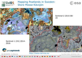
  • 1. Frank Martin Seifert | 06/10/2016 | Slide 1ESA UNCLASSIFIED - For Official Use Mapping Peatlands in Sweden: Store Mosse-Kävsjön 1 Sentinel-2 2015-08- 19 Sentinel-1 (VV) 2014- 2016 http://swos-service.eu
  • 2. ESA UNCLASSIFIED - For Official Use A New Generation of Data Sources 08/2005 - 2 Sent-1A/B Sent-2A/B Sent-3A/B Sent-5/5P Sent-6/Jason-CSSent-4A/B  Copernicus is a European space flagship programme led by the European Union  ESA coordinates the space component  Copernicus provides the necessary data for operational monitoring of the environment and for civil security  Data policy: free and open access  https://scihub.copernicus.eu/
  • 3. ESA UNCLASSIFIED - For Official Use … for today and for the future S1: Radar Mission S2: High Resolution Optical Mission S3: Medium Resolution Imaging and Altimetry Mission S4: Geostationary Atmospheric Chemistry Mission S5P: Low Earth Orbit Atmospheric Chemistry Precursor Mission S5: Low Earth Orbit Atmospheric Chemistry Mission S6 (Jason-CS): Altimetry Mission
  • 4. Frank Martin Seifert | 06/10/2016 | Slide 4ESA UNCLASSIFIED - For Official Use Sentinel-1 and Sentinel-2 Sentinel-2A / -2B • multispectral (13 bands) • 10 days repeat cycle (5 days with 2 satellites) • 290 km swath width  http://sentinel.esa.int/ Sentinel-1A / -1B • night and day radar imaging • C-band SAR • 12 days repeat cycle (6 days with 2 satellites)
  • 5. Frank Martin Seifert | 06/10/2016 | Slide 5ESA UNCLASSIFIED - For Official Use Congo Basin Short term changes 5
  • 6. Frank Martin Seifert | 06/10/2016 | Slide 6ESA UNCLASSIFIED - For Official Use Congo Basin Short term changes 6
  • 7. ESA UNCLASSIFIED - For Official Use Summary • The European Copernicus Programme will secure continuity of observations and data availability for the next 20+ years with free and open access for everybody  https://scihub.copernicus.eu/ • The Sentinels will be major workhorses for REDD+ and have a great potential for peatland mapping and monitoring; • ESA will support the Global Peatland Initiative with a dedicated project developing and demonstrating methodologies for peatland mapping and monitoring defined in dialogue with the GPI partners and users world-wide. ESA UNCLASSIFIED - For Official Use

Editor's Notes

  1. Sentinel-1: 3 channels of the S1 radar images: R – 5th percentile, G – median, B – 95% percentile from VV (dB) Sentinel-2: violett: R – 5, G – 3, B – 2 (Landsat 4,5,3 resp.5,6,4 for LS8) orange: R – 7, G – 2, B –3
  2. S3-B launch Q4/2017
  3. Colour composite of a pre-fire Sentinel-1 image (acquisition date: 13.8.2015), and a post-fire Sentinel-1 image (acquisition date: 24.9.2015)
  4. 1. we do not cover whole Indonesia 2. we calculate with different emission factors 3. we do not cover all burned areas within 2015 4. we use the idea of different burn depth based on number of fires 5. we use 17 cm instead of 30 cm  “Variable carbon losses from recurrent fires in drained tropical peatland“, Global Change Biology (2016) 22, 1469–1480, doi: 10.1111/gcb.13186