Download to read offline


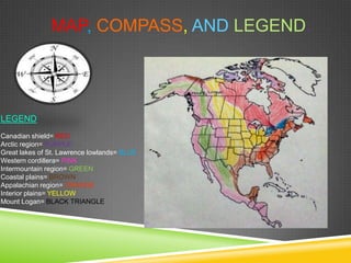


This document describes 8 physical regions of Canada: Canadian Shield, Arctic Region, Great Lakes-St. Lawrence Lowlands, Western Cordillera, Intermountain Region, Coastal Plains, Appalachian Region, and Interior Plains. For each region, it provides information on topography, climate, vegetation, economic activity, and environmental concerns. The document uses maps, legends, and illustrations to delineate and explain the characteristics of Canada's diverse physical geography.


