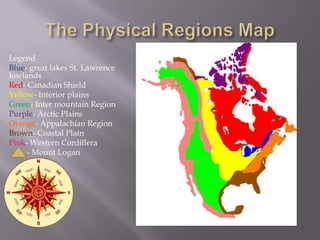
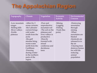
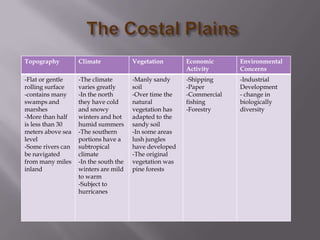
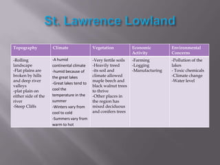
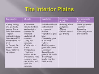
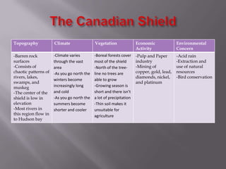
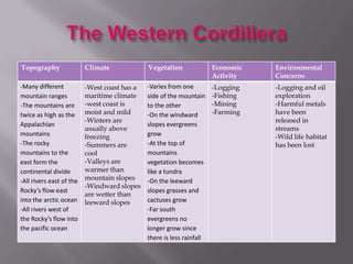
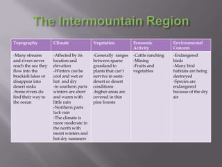
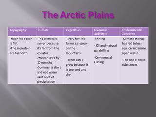
Appalachian Region
Coastal Plains
St. Lawrence Lowland
Interior Plains
Canadian Shield
Western Cordillera
Inter mountain Region
Arctic Region
Legend
Blue- great lakes St. Lawrence
lowlands
Red- Canadian Shield
Yellow- Interior plains
Green- Inter mountain Region
Purple- Arctic Plains
Orange- Appalachian Region
Brown- Coastal Plain
Pink- Western Cordillera
- Mount Logan
Topography

Climate

Vegetation

Economic
Activity

Environmental
Concern

-Low mountain
ranges
-Rolling hills
-River valleys
-Fertile
plateaus

-Affect by 2
ocean currents
-the Labrador
current brings
cold water
south from the
arctic
-the gulf
streams bring
warm water
north from the
Caribbean
-Freezing
during winter
in the northern
parts of the
region

-Poor and
unproductive
mountain soil
-The soil on the
plateaus and
river valleys is
productive
-Heavily
forested with
mixed
coniferous and
deciduous
trees

-Mining
-Logging
-Fishing
-Trade (Sea
ports)

-Destroying
mountains
through
mining
-When
mountains are
blasted
chemicals are
released in to
the air
-Clearing trees
destroys homes
for wild life
reducing
animal
population
Topography

Climate

Vegetation

Economic
Activity

Environmental
Concerns

-Flat or gentle
rolling surface
-contains many
swamps and
marshes
-More than half
is less than 30
meters above sea
level
-Some rivers can
be navigated
from many miles
inland

-The climate
varies greatly
-In the north
they have cold
and snowy
winters and hot
humid summers
-The southern
portions have a
subtropical
climate
-In the south the
winters are mild
to warm
-Subject to
hurricanes

-Manly sandy
soil
-Over time the
natural
vegetation has
adapted to the
sandy soil
-In some areas
lush jungles
have developed
-The original
vegetation was
pine forests

-Shipping
-Paper
-Commercial
fishing
-Forestry

-Industrial
Development
- change in
biologically
diversity
Topography

Climate

Vegetation

Economic
Activity

Environmental
Concerns

-Rolling
landscape
-Flat plains are
broken by hills
and deep river
valleys
-plat plain on
either side of the
river
-Steep Cliffs

-A humid
continental climate
-humid because of
the great lakes
-Great lakes tend to
cool the
temperature in the
summer
-Winters vary from
cool to cold
-Summers vary from
warm to hot

-Very fertile soils
-Heavily treed
-its soil and
climate allowed
maple beech and
black walnut trees
to thrive
-Other places in
the region has
mixed deciduous
and conifers trees

-Farming
-Logging
-Manufacturing

-Pollution of the
lakes
- Toxic chemicals
-Climate change
-Water level
Topography

Climate

Vegetation

Economic
Activity

Environmental
Concerns

-Gently rolling
and gradually
sloping down
from west to east
-High in
evaluation rising
from 600 to 1500
meters above sea
level
-In Canada the
interior plains
have 3 different
elevations

-Continental
climate due to its
location in the
center of the
continent
-A climate of
extremes
- Long hot
summers
-Cold winters
-Little
precipitation
- Northern
portion has an
artic climate with
extremely long
cold winters and
short cool
summers

-Mixed deciduous
and scattered
evergreens
-natural
vegetation is grass
land
-Trees only grow
in the river
valleys
-Prairie grasses
grow west of the
Mississippi
-boreal forests
grow in the north
-Becoming a
tundra near the
arctic ocean

-Farming wheat
and grains
-Mining
-Oil and natural
gas drilling

-Farm pollutants
-Lumber
harvesting
-Disposing waste
into landfills
Topography

Climate

Vegetation

Economic
Activity

Environmental
Concern

-Barren rock
surfaces
-Consists of
chaotic patterns of
rivers, lakes,
swamps, and
muskeg
-The center of the
shield is low in
elevation
-Most rivers in
this region flow in
to Hudson bay

-Climate varies
through the vast
area
-As you go north the
winters become
increasingly long
and cold
-As you go north the
summers become
shorter and cooler

-Boreal forests cover
most of the shield
-North of the treeline no trees are
able to grow
-Growing season is
short and there isn’t
a lot of precipitation
-Thin soil makes it
unsuitable for
agriculture

-Pulp and Paper
industry
-Mining of
copper, gold, lead,
diamonds, nickel,
and platinum

-Acid rain
-Extraction and
use of natural
resources
-Bird conservation
Topography

Climate

Vegetation

Economic
Activity

Environmental
Concerns

-Many different
mountain ranges
-The mountains are
twice as high as the
Appalachian
mountains
-The rocky
mountains to the
east form the
continental divide
-All rivers east of the
Rocky’s flow east
into the arctic ocean
-All rivers west of
the Rocky’s flow into
the pacific ocean

-West coast has a
maritime climate
-west coast is
moist and mild
-Winters are
usually above
freezing
-Summers are
cool
-Valleys are
warmer than
mountain slopes
-Windward slopes
are wetter than
leeward slopes

-Varies from one
side of the mountain
to the other
-On the windward
slopes evergreens
grow
-At the top of
mountains
vegetation becomes
like a tundra
-On the leeward
slopes grasses and
cactuses grow
-Far south
evergreens no
longer grow since
there is less rainfall

-Logging
-Fishing
-Mining
-Farming

-Logging and oil
exploration
-Harmful metals
have been
released in
streams
-Wild life habitat
has been lost
Topography

Climate

Vegetation

Economic
Activity

Environmental
Concern

-Many streams
and rivers never
reach the sea they
flow into the
brackish lakes or
disappear into
desert sinks
-Some rivers do
find their way to
the ocean

-Affected by its
location and
elevation
-Winters can be
cool and wet or
hot and dry
-in southern parts
winters are short
and warm with
little rain
-Northern parts
lack rain
-The climate is
more moderate in
the north with
moist winters and
hot dry summers

-Generally ranges
between sparse
grassland to
plants that can’t
survive in semidesert or desert
conditions
-higher areas are
covered in thin
pine forests

-Cattle ranching
-Mining
-Fruits and
vegetables

-Endangered
birds
-Many bird
habitats are being
destroyed
-Species are
endangered
because of the dry
air
Topography

Climate

Vegetation

Economic
Activity's

Environmental
Concerns

-Near the ocean
is flat
-The mountain
are far north

-The climate is
server because
it’s far from the
equator
-Winter lasts for
10 months
-Summer is short
and not warm
-Not a lot of
precipitation

- Very few life
forms can grow
on the
mountains

-Mining

-Climate change
has led to less
sea ice and more
open water

- Trees can’t
grow because it
is too cold and
dry

- Oil and natural
gas drilling
-Commercial
Fishing

-The use of toxic
substances
Cranny , Micheal . CROSSROADS A MEETING OF THE NATIONS. Toronto Canada : Pearson
Education Canada , 1998. Print.

mcgill, seamus. Compass Rose . 2006. Photograph. Wikimedi commons Web. 16 Feb 2014.
<http://upload.wikimedia.org/wikipedia/commons/d/d8/Compass_rose_browns_00.png>.
Williams , Tim. "The arctic environmental issues ." Parliment of Canada . N.p., 24 10 2008. Web. 16 Feb
2014. <-http://www.parl.gc.ca/content/lop/researchpublications/prb0804-e.htm >.
Parks , Noreen . "Arctic Facts ." The Arctic . N.p., n.d. Web. 16 Feb 2014. <-http://arctic.ru/arcticfacts >.
. The geography of canada . N.p.. Web. 16 Feb 2014. <-http://www.dlcubc.ca/wordpress_dlc_mu/jeff1/files/2010/07/Geography-of-Canada.pdf>.
"North americas regional geography ." Quizlet . Quizlet , n.d. Web. 16 Feb 2014.
<http://quizlet.com/1005311/north-americas-regional-geography-flash-cards/>.
Territorial evolution of North America. N.d. Photograph. Wikipedia Web. 17 Feb 2014.
<http://en.wikipedia.org/wiki/Territorial_evolution_of_North_America_since_1763>.

The 8 physical regions

  • 1.
    Appalachian Region Coastal Plains St.Lawrence Lowland Interior Plains Canadian Shield Western Cordillera Inter mountain Region Arctic Region
  • 2.
    Legend Blue- great lakesSt. Lawrence lowlands Red- Canadian Shield Yellow- Interior plains Green- Inter mountain Region Purple- Arctic Plains Orange- Appalachian Region Brown- Coastal Plain Pink- Western Cordillera - Mount Logan
  • 3.
    Topography Climate Vegetation Economic Activity Environmental Concern -Low mountain ranges -Rolling hills -Rivervalleys -Fertile plateaus -Affect by 2 ocean currents -the Labrador current brings cold water south from the arctic -the gulf streams bring warm water north from the Caribbean -Freezing during winter in the northern parts of the region -Poor and unproductive mountain soil -The soil on the plateaus and river valleys is productive -Heavily forested with mixed coniferous and deciduous trees -Mining -Logging -Fishing -Trade (Sea ports) -Destroying mountains through mining -When mountains are blasted chemicals are released in to the air -Clearing trees destroys homes for wild life reducing animal population
  • 4.
    Topography Climate Vegetation Economic Activity Environmental Concerns -Flat or gentle rollingsurface -contains many swamps and marshes -More than half is less than 30 meters above sea level -Some rivers can be navigated from many miles inland -The climate varies greatly -In the north they have cold and snowy winters and hot humid summers -The southern portions have a subtropical climate -In the south the winters are mild to warm -Subject to hurricanes -Manly sandy soil -Over time the natural vegetation has adapted to the sandy soil -In some areas lush jungles have developed -The original vegetation was pine forests -Shipping -Paper -Commercial fishing -Forestry -Industrial Development - change in biologically diversity
  • 5.
    Topography Climate Vegetation Economic Activity Environmental Concerns -Rolling landscape -Flat plains are brokenby hills and deep river valleys -plat plain on either side of the river -Steep Cliffs -A humid continental climate -humid because of the great lakes -Great lakes tend to cool the temperature in the summer -Winters vary from cool to cold -Summers vary from warm to hot -Very fertile soils -Heavily treed -its soil and climate allowed maple beech and black walnut trees to thrive -Other places in the region has mixed deciduous and conifers trees -Farming -Logging -Manufacturing -Pollution of the lakes - Toxic chemicals -Climate change -Water level
  • 6.
    Topography Climate Vegetation Economic Activity Environmental Concerns -Gently rolling and gradually slopingdown from west to east -High in evaluation rising from 600 to 1500 meters above sea level -In Canada the interior plains have 3 different elevations -Continental climate due to its location in the center of the continent -A climate of extremes - Long hot summers -Cold winters -Little precipitation - Northern portion has an artic climate with extremely long cold winters and short cool summers -Mixed deciduous and scattered evergreens -natural vegetation is grass land -Trees only grow in the river valleys -Prairie grasses grow west of the Mississippi -boreal forests grow in the north -Becoming a tundra near the arctic ocean -Farming wheat and grains -Mining -Oil and natural gas drilling -Farm pollutants -Lumber harvesting -Disposing waste into landfills
  • 7.
    Topography Climate Vegetation Economic Activity Environmental Concern -Barren rock surfaces -Consists of chaoticpatterns of rivers, lakes, swamps, and muskeg -The center of the shield is low in elevation -Most rivers in this region flow in to Hudson bay -Climate varies through the vast area -As you go north the winters become increasingly long and cold -As you go north the summers become shorter and cooler -Boreal forests cover most of the shield -North of the treeline no trees are able to grow -Growing season is short and there isn’t a lot of precipitation -Thin soil makes it unsuitable for agriculture -Pulp and Paper industry -Mining of copper, gold, lead, diamonds, nickel, and platinum -Acid rain -Extraction and use of natural resources -Bird conservation
  • 8.
    Topography Climate Vegetation Economic Activity Environmental Concerns -Many different mountain ranges -Themountains are twice as high as the Appalachian mountains -The rocky mountains to the east form the continental divide -All rivers east of the Rocky’s flow east into the arctic ocean -All rivers west of the Rocky’s flow into the pacific ocean -West coast has a maritime climate -west coast is moist and mild -Winters are usually above freezing -Summers are cool -Valleys are warmer than mountain slopes -Windward slopes are wetter than leeward slopes -Varies from one side of the mountain to the other -On the windward slopes evergreens grow -At the top of mountains vegetation becomes like a tundra -On the leeward slopes grasses and cactuses grow -Far south evergreens no longer grow since there is less rainfall -Logging -Fishing -Mining -Farming -Logging and oil exploration -Harmful metals have been released in streams -Wild life habitat has been lost
  • 9.
    Topography Climate Vegetation Economic Activity Environmental Concern -Many streams and riversnever reach the sea they flow into the brackish lakes or disappear into desert sinks -Some rivers do find their way to the ocean -Affected by its location and elevation -Winters can be cool and wet or hot and dry -in southern parts winters are short and warm with little rain -Northern parts lack rain -The climate is more moderate in the north with moist winters and hot dry summers -Generally ranges between sparse grassland to plants that can’t survive in semidesert or desert conditions -higher areas are covered in thin pine forests -Cattle ranching -Mining -Fruits and vegetables -Endangered birds -Many bird habitats are being destroyed -Species are endangered because of the dry air
  • 10.
    Topography Climate Vegetation Economic Activity's Environmental Concerns -Near the ocean isflat -The mountain are far north -The climate is server because it’s far from the equator -Winter lasts for 10 months -Summer is short and not warm -Not a lot of precipitation - Very few life forms can grow on the mountains -Mining -Climate change has led to less sea ice and more open water - Trees can’t grow because it is too cold and dry - Oil and natural gas drilling -Commercial Fishing -The use of toxic substances
  • 11.
    Cranny , Micheal. CROSSROADS A MEETING OF THE NATIONS. Toronto Canada : Pearson Education Canada , 1998. Print. mcgill, seamus. Compass Rose . 2006. Photograph. Wikimedi commons Web. 16 Feb 2014. <http://upload.wikimedia.org/wikipedia/commons/d/d8/Compass_rose_browns_00.png>. Williams , Tim. "The arctic environmental issues ." Parliment of Canada . N.p., 24 10 2008. Web. 16 Feb 2014. <-http://www.parl.gc.ca/content/lop/researchpublications/prb0804-e.htm >. Parks , Noreen . "Arctic Facts ." The Arctic . N.p., n.d. Web. 16 Feb 2014. <-http://arctic.ru/arcticfacts >. . The geography of canada . N.p.. Web. 16 Feb 2014. <-http://www.dlcubc.ca/wordpress_dlc_mu/jeff1/files/2010/07/Geography-of-Canada.pdf>. "North americas regional geography ." Quizlet . Quizlet , n.d. Web. 16 Feb 2014. <http://quizlet.com/1005311/north-americas-regional-geography-flash-cards/>. Territorial evolution of North America. N.d. Photograph. Wikipedia Web. 17 Feb 2014. <http://en.wikipedia.org/wiki/Territorial_evolution_of_North_America_since_1763>.