
Recommended
More Related Content
What's hot
What's hot (20)
Similar to 6-97_De Mark P and Callaghan T_33
Similar to 6-97_De Mark P and Callaghan T_33 (20)
6-97_De Mark P and Callaghan T_33
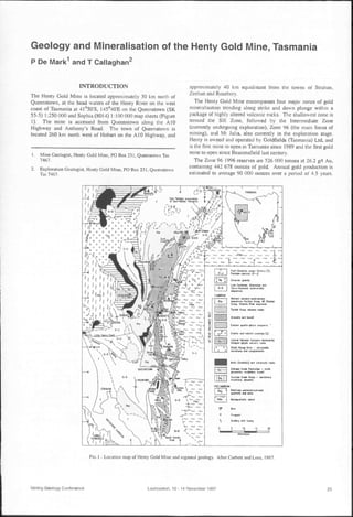
- 1. Geology and Mineralisation of the Henty Gold Mine, Tasmania P De Mark1 and T Callaghan2 I TRODUCTIO The Henty Gold Mine is located approximately 30 km north of Queenstown, at the head waters of the Henty River on the west coast of Ta mania at 41°50'S, 145°40'E on the Queenstown (SK 55-5) 1:250000 and Sophia (8014) I: 100 000 map sheets (Figure 1). The mine is accessed from Queenstown along the A I0 Highway and Anthony's Road. The town of Queenstown is located 260 km north west of Hobart on the A I0 Highway, and I. Mine Geologist, Henty Gold Mine, PO Box 231, QlIeenstown Tas 7467. 2. Exploration Geologist, Henty Gold Mine, PO Box 231, QlIeenstown Tas 7467. approximately 40 km equidistant from the towns of Strahan, Zeehan and Rosebery. The Henty Gold Mine encompasses four major zones of gold mineralisation trending along strike and down plunge within a package of highly altered volcanic rocks. The shallowest zone is termed the Sill Zone, followed by the Intermediate Zone (currently undergoing exploration), Zone 96 (the main focus of mining), and Mt Julia, also currently in the exploration stage. Henty is owned and operated by Goldfields (Tasmania) Ltd, and is the first mine to open in Tasmania since 1989 and the first gold mine to open since Beaconsfielcl last century. The Zone 96 1996 reserves are 526 000 tonnes at 26.2 g/t Au, containing 442 678 ounces of gold. Annual gold production is estimated to average 90 000 ounces over a period of 4.5 years. 0;".., 0'.. formation - moftc 9'"t)WCU. ftlCbtonc. batalt Sucaa 0'_ Croup - .and,larM. lI'IUatOM, ddomit. Ctnlral YoICO"11c Ccw'nPu-domhaltl,f......-pIl)fk _ _• Stictlt RIM,. BedI - wiiddo.lic: ..-.drlane cnd CGn4JIarnrat. ==,,:~o:c;:t":.l~ "'Grlr CrOUf!. YoIGrl6t Rf¥w MqlHnCI T~ Croup voIccni<: rocb ~ .... "'-, B~""""" '9 't 1Klorncltt. ~AH 1e,.1 ~ ~~u ~ Mdetit. and botalt i ~ Eolttm ",arb-ph)ric ~.-tC•• ~ 0 Granite and related porph" (.) i~ D _ Wale (thokitic) and ulltll'nDfic rDCb Ea mmPll£CAIlIlIlI.lH ~R_,_~ ~ qucrlzit._~. ~ ..~.. td'liJt FIG 1 - Location map of Henty Gold Mine and regional geology. After Corbett and Lees, 1987. Mining Geology Conference Launceston, 10 - 14 November 1997 25
- 2. P De MARK and T CALLAGHAN During the 1996-1997 financial year, Henty produced 74 930 tonnes at 21.1 g/t Au, recovering 48 377 ounces. Exploration and mining history Exploration in the Henty area was initiated by Renison Ltd in 1966. In 1973, samples from a costean over an IP and soil geochemical anomaly at the current portal pad returned 2.4 m of semi-massive sulphide mineralisation at 1.8 per cent Cu, 1.76 per cent Pb, 0.2 per cent Zn, and 37.89 per cent FeS2. At this time samples were not assayed for Au. Two diamond drill holes into the costean intersected only a narrow sulphide lens. Goldfields Exploration Pty Ltd took over the exploration license in 1982 and drilled three diamond holes the following year, with two of them again intersecting thin massive sulphide mineralisation. Routine gold assaying began at this time and returned high gold values for the massive sulphide intersection and another silica-pyrite alteration zone. Wider exploration around the site of the Henty Gold Mine renewed in 1984 when EL 9/66 became due for reduction. The area was reinterpreted and previous drill holes were assayed for Au. HFZ05, one of the first diamond drill holes sited at the portal pad, returned an intersection of 6.7 m at 7 g/t Au. Exploration intensified on the basis of these results, and from 1984 to 1988 a further 38 diamond holes were drilled, identifying a shallow gold resource between 50 and 150 m below the surface over a strike length of 650 m, known as the Sill Zone. The initial resource estimate of the Sill Zone in 1987 was 500 000 tonnes at 10 g/t Au. However, the irregular spatial distribution and style of mineralisation observed in drill holes required further work to prove geological continuity and sufficient tonnes and grade to economically develop the deposit. In November 1988 development commenced on an 800 m long exploration decline and a 200 m long ore drive into the Sill Zone to further define mineralisation. Results from a 25 m by 25 m spaced diamond drilling program and methodical sampling of the ore drive delineated insufficient mineable reserves to justify further development of the Sill Zone. However, continued diamond drilling located a deeper target down plunge of the Sill Zone mineralisation at 350 to 550 m below the surface. In September 1989, diamond drill hole HP096A intersected 7.5 m at 107.1 g/t Au. During the next three years the Zone 96 area, named in honour of the bonanza drill hole, was drilled to 40 m by 30 m spacing, identifying a mineable reserve of 526 000 tonnes at 26.2 g/t Au. Following a feasibility study undertaken between 1990 and 1992, Goldfields decided to drill a shaft to access the deeper mineralisation. Excavation of the decline leading to the underground shaft collar and drilling of the internal shaft commenced in 1993. Henty officially opened in July 1996 after a three-year pre-production period and an investment of $53 million. Because of delays encountered in accessing the Zone 96 orebody, mining of the Sill Zone during 1995 - 1996 provided approximately 22 000 tonnes at 7.09 g/t Au for the commissioning of the gold plant. Development driving from the bottom of the shaft intersected the Zone 96 orebody in October 1996. A 250 m spaced diamond drilling program in late- I995 identified Henty-style mineralisation at Mount Julia approximately 1.3 km south of the current mine workings. A 150 m by 75 m spaced infill drilling program is presently under way and is expected to be completed by the end of 1997. Drilling of the Intermediate Zone, located between the Sill Zone and Zone 96 orebodies, has been on-going since late-1996. Should infill drilling programs in these areas prove to be successful, an incline to the Intermediate Zone and a decline to Mt Julia from Zone 96 will be considered. REGIONAL GEOLOGY Henty lies within the Cambrian Mount Read Volcanic Belt, a rich mineral zone that hosts the Hellyer, Que River, Rosebery, Hercules and Mt Lyell ore deposits. The Mount Read Volcanics form a 20 km wide arcuate belt of submarine and subaerial rhyolitic to basaltic lavas, intrusions, and volcaniclastics with a strike length of over 200 km, lying along the eastern margin of the Dundas Trough. They are bound to the east by Precambrian basement rocks of the Tyennan Region, interfinger Cambrian volcano-sedimentary rocks of the Dundas Group to the west and are overlain by Late Cambrian to Early Ordovician siliciclastics of the Owen Conglomerate. Stratigraphy Corbett (1992), Corbett and Lees (1987) and White and McPhie (1996) have documented the stratigraphy of the Mount Read Volcanics and form the basis of the following summary. The Cambrian Mount Read Volcanics may be divided into four major lithostratigraphic units comprising the Central Volcanic Sequences, the Eastern quartz-porphyritic sequence, the Western volcano-sedimentary sequences (comprising the Yolande River sequence, the Dundas Group, and the Mount Charter Group), and the Tyndall Group (Figure I). The NNE trending Henty Fault Zone was active during the deposition of the Tyndall Group rocks, causing rapid facies changes in its vicinity, and divides these sequences into two distinctly differing stratigraphic and structural domains. Southeast of the Henty Fault, volcaniclastics, mudstones, and sandstones of the Western volcano-sedimentary sequences overlie or interfinger with the Central Volcanic Sequences. The Central Volcanic Sequences comprises mainly rhyolitic to dacitic lavas, pyroclastics, and intrusives, and is characterised by potassic rhyolites. The Eastern quartz-porphyritic sequence mainly comprise quartz porphyritic volcanics, intrusives, and volcaniclastics intertingering with the Central Volcanic Sequences. The Tyndall Group mainly comprises rhyolitic volcanics and volcaniclastic breccia, conglomerate, sandstone, and mudstone and overlie both the Western volcano-sedimentary sequences and the Central Volcanic Sequences, in places unconformably. The Mount Read Volcanics are overlain by the Owen Conglomerate, a thick sequence of shallow marine to fluvial conglomerate derived from the rapid uplift of the Precambrian Tyennan basement rocks. The Newton Creek Sandstone locally occupies the base of the Owen Conglomerate and unconformably overlies or intertingers with the Tyndall Group. Northwest of the Henty Fault, the Central Volcanic Sequences comprises lavas and pyroclastics dominated by dacites and andesites. The Central Volcanic Sequences is unconformably overlain by felsic tuft's, siltstones, greywackes, slates, mudstones, and conglomerates of the Dundas Group. Regional structural setting The NNE trending Henty Fault, a Late Cambrian structure running for over 60 km between Mount Charter and Mount Read, dominates the structure in the centre of the Mount Read Volcanics (Figure I). The Henty Fault dips at 70° to the west and diverges into the North and South Henty Faults at its southern extremity near Mount Read. The Great Lyell Fault, a major Cambrian structure reactivated in the Devonian, trends south of and parallel to the Henty Fault and possibly intersects it near the Henty Gold Mine. The Henty and Great Lyell Faults formed the western margin of an active graben during deposition of the Owen Conglomerate. Other important structures in the area are Devonian NNW trending broad, open folds and later NW trending folds and faults, and a strong steeply dipping, NNW trending regional foliation. 26 launceston, 10·14 November 1997 Mining Geology Conference
- 3. GEOLOGY AND MINERALISATION OF THE HENTY GOLD MINE FIG 3 - Cross section through Henty Gold Mine at 54 900 mN. i11 GEOLOGJCAI. LEGEJII =.,CooC';o:... Zl;l"QIII- ~1""f>/fIrY_.AlII_ CMtII_~ I«l IN 111 ca AS lIA ..Il :: West """KL MINE GEOLOGY Mineralisation of the Mt Read Volcanic Belt Henty is contemporary with the high-grade Cambrian Pb-Zn-Cu- Au-Ag VHMS deposits at Hellyer, Que River, Rosebery and Hercules and the Cu-Au Mt Lyell deposit in the Mt Read Volcanic Belt. The high-grade gold deposits at Henty are a new style of mineralisation in the Mount Read Volcanics, and are the only economic deposits hosted in Tyndall Group rocks. Henty is a remarkably Au-rich volcanogenic gold deposit at nearly 30 g1t Au, compared to an average of 2.8 g/t Au for other Tasmanian volcanogenic deposits and an average of 1.8 g/t Au for deposits world wide (Halley and Roberts, in press). Pb isotope ratios from samples taken from gold-rich alteration types at Henty, including quartz infill in Devonian tension gashes, are highly uniform and lie in the same field as the other Cambrian Mount Read Volcanic deposits (Halley and Roberts, in press). tratigraphy The Henty mine lease covers rocks of the Central Volcanic Sequences, the Henty Fault Sequences, and Tyndall Group rocks of the Mount Read Volcanics and the overlying Owen Conglomerate (Figures 2 and 3). Near the mine, the Henty Fault splays into the North and South Henty Faults, dividing theFIG 2 - Plan of Henty Gold Mine and local geology. AMO 78000N AMO 64000N Mining Geology Conference Launceston. 10 - 14 November 1997 27
- 4. P De MARK and T CALLAGHAN geology into segments to the east and west of the faults, and a package between the splays. Gold mineralisation is hosted in Tyndall Group rocks to the east of the Henty Fault. Rocks to the west of the Henty Fault comprise dominantly pink, feldspar phyric dacitic lavas and coarse grained crystal-rich volcanics of the Central Volcanic Sequences. Numerous chloritised, fine grained tholeiitic dykes of the Henty Dyke Swarm intrude rocks of the Central Volcanic Sequences. The Henty Fault Sequences lie between the North and South Henty Faults and comprise carbonaceous black shales, mafic to ultramafic volcanics, and quartz phyric volcaniclastics. Rocks to the east of the Henty Fault comprise quartz phyric volcanics of the Tyndall Group and siliciclastics of the Newton Creek Sandstone of the Owen Conglomerate. Minor altered dacitic volcaniclastics and lavas of the Central Volcanic Sequences also occur east of the Henty Fault in the southern area of the lease. White and McPhie (1996) have divided the Tyndall Group rocks into the overlying Zig Zag Hill Formation and the underlying Comstock Formation, which broadly correspond to the Upper and Lower Tyndall Groups of Corbett (1974, 1988, 1992). They have further subdivided the Comstock Formation into the upper Mount Julia Member and the lower Lynchford Member, which hosts the Henty orebodies. In the mine area, the Lynchford Member comprises green to red, massive coarse grained crystal-rich feldspar phyric volcaniclastic sandstone with lesser siltstones and matrix supported lithic breccias and minor interbedded cherts and cream, pink, or purple carbonates. Original textures are still discernible despite subsequent hydrothermal alteration and deformation. Basal units of the Mount Julia Member comprise massive quartz crystal-rich volcaniclastics and autobrecciated and flow banded rhyolites which thicken rapidly from north to south, coinciding with a swing in the strike of lithology from 340° to 020°, subparallel to the Henty Fault. The basal units of the Mount Julia Member are present at Mt Julia but are not present at the Henty Mine. The middle and upper portions of the Mount Julia Member comprise polymictic volcaniclastic greywacke, graded mass flows, quartz crystal-rich volcaniclastic sandstones and epiclastic shales, overlain by massive crystal-rich volcaniclastic sandstones with minor matrix supported diamictic breccias. The overlying Zig Zag Hill Formation comprises polymictic volcaniclastic conglomerate, coarse grained quartz crystal sandstones, and laminated siltstones. Abundant quartz-feldspar to quartz porphyritic rhyolites occur throughout the Tyndall Group, along with pepperitic and autoclastic sills, dykes, and flows. This rhyolite complex intruded the Comstock Formation lithologies and formed subaqueous extrusives and lava domes with associated autoclastic deposits at the top of the Comstock Formation and within the Zig Zag Hill Formation. The autoclastic deposits were extensively reworked and formed a large localised sediment source for the Zig Zag Hill Formation. Structure The Henty orebodies are hosted east of the Henty Fault (Figure 3), on the steeply west dipping overturned western limb of a shallowly south plunging asymmetric syncline trending into the Henty Fault. The orebodies plunge at 45° to the south between the Sill Zone and Zone 96, and shallow at depth towards Mt Julia. The mineralised zone at Zone 96 is up to 300 m long, 30 m wide, and 200 m high. The lithologies and regional foliation strike at 340° with a steep westerly dip, and swing parallel to the Henty Fault as they approach the structure. Two generations of cleavages (S I and S2) overprint the orebodies, with the earlier SI cleavage dragged into the later Devonian S2 cleavage. The structure of the Henty Gold Mine is dominated by the steeply west dipping Henty Fault Zone, which splays into the North and South Henty Faults in the middle of the lease. The 20 m wide South Henty Fault forms the upper boundary to mineralisation, and truncates it to the south. At depth the vertically dipping orebodies become increasingly separated from the westerly dipping fault. Adjacent to the South Henty Fault, foliation ·intensifies and lithologies become brecciated and mylonitised. The orebodies are disrupted by numerous north- south trending, steeply west dipping brittle-ductile faults with displacements of up to a few metres. Alteration Nearly all of the stratigraphic units of the Tyndall Group present at the Henty Gold Mine have undergone hydrothermal alteration. The most intense quartz-sericite-sulphide alteration and gold mineralisation has affected the Lynchford Member of the Comstock Formation, adjacent to the Henty Fault, and is referred to as 'A-Zone' type alteration. A Zone alteration types include MA, MZ, MV, MQ, MP, and CB (Figure 3). The main mineralised zone comprises MQ, MV, and MZ, and are the alteration types followed in underground ore drives. From west to east, the alteration types are as follows: MA (sericite-quartz ± pyrite ± carbonate ± feldspar± fuchsite schist) - The MA alteration type ranges between 15 and 60 m thick and lies between the Henty Fault to the west and A Zone type alteration to the east. It is an orange, brown, to green moderately to strongly altered, highly foliated to mylonitic rock. The original lithology is believed to be coarse epiclastic mass flows and sandstones (Taheri and Green, 1991). MZ (quartz-sericite-suLphide schist)- is a black, fine grained, sheared and brecciated rock containing quartz, sericite, pyrite, local carbonate and minor chlorite, feldspar, chalcopyrite, sphalerite and galena. The MZ contains less silica and sericite than the MQ and MV afteration types and is less strongly foliated, and has a higher sulphide content at about five per cent. MZ is volumetrically the most abundant alteration type in the mineralised zone, ranging between 2 and 30 m thick and is present stratigraphically above and below the MQ and MV alteration types. It contains discontinuous lenses of MQ and MY. Petrographic studies support a felsic epiclastic origin for the MZ, MV, and MQ alteration types (Taheri and Green, 1991). The MZ averages 0.6 glt Au. MV (quartz-sericite-carbonate-suphide schist)- is a yellow- green, fine grained, highly foliated rock containing quartz, sericite, pyrite and local carbonate and minor chlorite, feldspar, chalcopyrite, sphalerite, and galena and rare purple fluorite. The total sulphide content is less than one per cent. MV is the second most volumetrically abundant alteration type in the mineralised zone, followed by MQ and MP. The MV forms I to 15 m thick lenses and commonly envelops the MQ alteration type. It extends for tens of metres beyond the most northerly lenses of MQ and is more extensively developed on the hangingwall side of the MQ, where it is associated with elevated gold values and base metal mineralisation. The MV averages 4.0 g/t Au. MQ (massive quartz-suLphide-native goLd) - is a grey, cream, or pink massive to recrystallised brecciated quartz rock with minor muscovite, sericite, pyrite, carbonate and chalcopyrite, with lesser galena and sphalerite and rare gold and bismuth metal. Si02 forms 90 - 95 per cent of the rock mass and the total sulphide content is about two per cent. It forms lenses 2 to 50 m long and up to 8 m wide. RemobiJised sulphides, gold, and carbonates till late horizontal tension gashes in the MQ formed during Devonian deformation. The MQ averages 55 g/t Au. Thicker zones of MQ contain higher gold values. MP (massive pyrite-carbonate-quartz±goLd) - is a bronze- black massive pyritic rock containing 40 to 80 per cent pyrite 28 Launceston. 10 - 14 November 1997 Mining Geology Conference
- 5. with interstitial carbonate and quartz. It forms discontinuous lenses about 10 to 20 cm thick and a few metres long and is hosted in the MZ. It has undergone extensive fracturing, brecciation, and recrystallisation. CB (massive carbonate) - The CB alteration type forms the hangingwall of A Zone type alteration and occurs as white to pink laterally discontinuous lenses up to 5 m thick containing carbonate, sericite, sulphides, albite and red jasper fragments, with a banded to stylolitic texture. The massive carbonate beds are commonly interbedded with feldspar phyric sandstones and siltstones of the Lynchford Member. It is possible that the CB is an original lithology rather than an alteration product. AS (albite-silica alteration) - occurs to the east of the A Zone alteration and overprints volcaniclastics of the Lynchford Member and pervades up through the Mount Julia Member and the overlying Zig Zag Hill Formation. The alteration occurs as an irregular pervasive flood of massive white or orange fine grained silica and albite, completely destroying original textures of the volcaniclastics. Mineralisation Gold at the Henty Mine is present as both free gold and gold-rich electrum associated with chalcopyrite and galena in the main mineralised zone (MQ, MV, MZ). The electrum forms irregular grains ranging in size from I J..lm to about 15 mm. Initial studies (Taheri and Green, 1991) show that most grains are on the order of 5 to 15 ~lm and are found in microfractures, pyrite grain boundaries, cleavages in galena, or as inclusions in quartz, carbonate, pyrite, chalcopyrite and galena. The presence of gold along grain boundaries or microfractures indicates remobilisation of gold and later recrystallisation. Gold is also found in subhorizontal quartz tension gash veins in MQ associated with Devonian deformation. Ore genesis The initial Cambrian system formed sub seafloor by similar processes to VMS systems but was probably low in base metals and had a gold content of about 2 to 3 g/t Au. Devonian deformation remobilised the gold to form the current high grade gold deposit. One model (eg Halley and Roberts, in press) suggests that Henty is a Middle to Late Cambrian volcanogenic gold deposit, formed in the actively filling shallow water Dundas Trough, at the footwall of the early Henty Fault. The deposit is laterally and vertically zoned away from the Henty Fault, with proximal sub- sea floor quartz-sericite alteration and Cu, Au, Pb, and Bi mineralisation and distal10w level Zn, Pb, carbonate, jasper, and GEOLOGY AND MINERALISATION OF THE HENTY GOLD MINE massive pyrite lenses at or below the sea floor. This interpretation has mineralisation synchronous with deposition of the Lynchford Member and positioned within 10 to 20 m of the sea floor. A second interpretation is that the sea floor position was higher in the stratigraphy during mineralisation, possibly at the top of the Tyndall Group. Hangingwall carbonate horizons may be replacement rather than primary features, and Na stripped from the volcanic rocks in the A zone may have remobilised into the overlying intense albite-silica alteration." Both models suggest that subsequent Devonian deformation repeatedly fractured and veined the brittle MQ lenses and intensely foliated the more ductile, sericitic MV lenses. Au, pyrite, chalcopyrite, and galena sourced from the MV and MZ lithologies locally remobilised on the scale of a few metres, and recrystallised into late brittle fractures in the MQ. ACKNOWLEDGEMENTS Thanks to S Dunham for the opportunity to write this paper and for subsequent discussions regarding the history and geology of the Henty Mine. Thanks also to W Edgar and D Glover of Henty Gold Mine, Dr R Berry at the University of Tasmania, and Kim Denwer and Michael Vicary of RGC Exploration for reviewing drafts of the paper. REFERENCES Corbett, K D, Reid, K 0, Corbet!, E B, Green, G R, Wells, K and Sheppard, N W, 1974. The Mount Read Volcanics and Cambrian- Ordovician relationships at Queenstown, Tasmania, Journal of the Geological Society (!{Australia, 21:173-186. Corbet!, K D and Lees, T C, 1987. Stratigraphic and structural relationships and evidence for Cambrian deformation at the western margin of the Mt Read Volcanics, Tasmania, Australian Journal of Earth Sciences, 34:45-67. Corbett, K D, 1988. Geological compilation map of the Mt Read Volcanics and associated rocks, Hellyer to South Darwin Peaks, Tasmanian Department of Mines, Mt Read Volcanics Project Map 2. COl'bet!, K D, 1992. Stratigraphic-volcanic setting of massive sulfide deposits in the Cambrian Mount Read Volcanics, Tasmania, Economic Geology, 87:564-586. Halley, S Wand Roberts, R H, in press. Henty: A shallow-water, gold- rich VMS deposit in western Tasmania. Taheri, J and Green, G R, 1991. The origin of the gold mineralisation at the Henty Prospect, Division of Mines and Mineral Resources. White, M J and McPhie, J, 1996. Stratigraphy and paleovolcanology of the Cambrian Tyndall Group, Mt Read Volcanics, western Tasmania, Australian Journal (!{Earth Sciences, 43:147-159. Mining Geology Conference Launceston, 10- 14 November 1997 29
- 6. 30 Launceslon, 10 - 14 November 1997 Mining Geology Conference