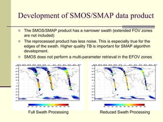
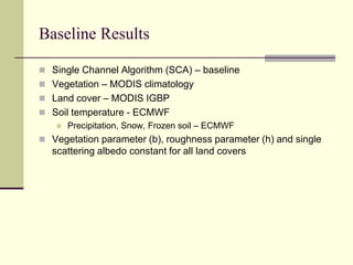
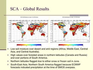
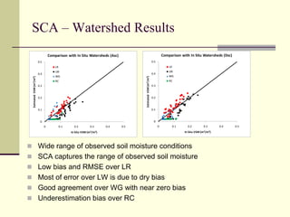
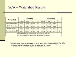
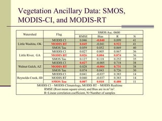
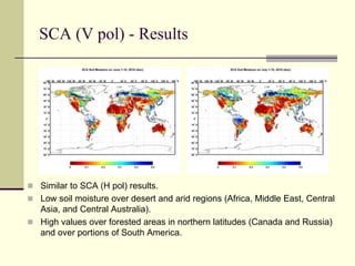
EVALUATION OF SMAP LEVEL 2 SOIL MOISTURE ALGORITHMS USING SMOS DATARajat Bindlish1, Thomas Jackson1, Tianjie Zhao1, Michael Cosh1, Steven Chan2, Peggy O'Neill3, Eni Njoku2, Andreas Colliander2, Yann H. Kerr4, Jiancheng Shi51USDA ARS Hydrology and Remote Sensing Lab, Beltsville, MD2Jet Propulsion Lab, Pasadena, CA3NASA Goddard Space Center, Greenbelt, MD4CESBIO, France5University of California, Santa Barbara, CA
ObjectivesReprocess SMOS observations to simulate SMAP observations at a constant incidence angle of 40o. This provides a brightness temperature data set that closely matches the observations that would be provided by the SMAP radiometer.Conduct an evaluation of the different SMAP soil moisture algorithms under consideration using the simulated data.Results will aid in the development and selection of the different land surface parameters (roughness and vegetation) and ancillary data sets.
EvaluationsAnalysis will involve several steps that will progressively move toward the actual SMAP characteristics.Evaluate the SMAP ancillary data optionsVegetationSMOS TauMODIS ClimatologyReal time MODISSoil TemperatureECMWFGMAO/MERRANCEPAlgorithm inter-comparisonsSingle Channel Algorithm (H-pol) (baseline)Single Channel Algorithm (V-pol)Dual Channel AlgorithmLPRM
MetricsUSDA ARS watershedsSMOS soil moistureECMWF soil moisture SCAN sitesOther sites from the ISMN and SMOS Cal/Val
USDA watersheds
ApproachDevelop a SMOS/SMAP data product that includes TBH and TBV at an incidence angle of 40o.Evaluate the algorithms using different ancillary dataset for soil moisture retrievals.Full SMAP retrievals using SMOS/SMAP data along with SMAP ancillary data sets on SMAP grid.Period of Analysis: Nov 2009 - May 2011
Development of SMOS/SMAP data productUses L1c dataSMOS observations from extended FOV areas can influence the overall brightness temperatures for a location (x,y)The use of observations from alias-free zones provides a more reliable TB at 40o. Observations from extended FOV are noisier.600 km1400 km
Basic steps performed in this processing:Removing the aliased portions of the SMOS orbitFiltering to remove anomalous TB observations + RFI checkInterpolation to fill-in full/dual-pol TB observations for each snapshotTransforming from antenna to Earth reference frame (Computing X-Y to H-V TB)RFI check (0<TB<320 K, TBH<TBV)Curve fitting of available TB observations at multiple incidence angles to estimate 40o TBDevelopment of SMOS/SMAP data product
Development of SMOS/SMAP data productThe SMOS/SMAP product has a narrower swath (extended FOV zones are not included)The reprocessed product has less noise. This is especially true for the edges of the swath. Higher quality TB is important for SMAP algorithm development.SMOS does not perform a multi-parameter retrieval in the EFOV zonesFull Swath ProcessingReduced Swath Processing
Baseline ResultsSingle Channel Algorithm (SCA) – baselineVegetation – MODIS climatologyLand cover – MODIS IGBPSoil temperature - ECMWFPrecipitation, Snow, Frozen soil – ECMWFVegetation parameter (b), roughness parameter (h) and single scattering albedo constant for all land covers
SCA – Global ResultsLow soil moisture over desert and arid regions (Africa, Middle East, Central Asia, and Central Australia).High values over forested areas in northern latitudes (Canada and Russia) and over portions of South America.Northern latitudes flagged due to either snow or frozen soil in June. South-East Asia, Northern South America flagged because ECMWF forecasts indicated precipitation at the time of SMOS overpass.
SCA – Watershed ResultsWide range of observed soil moisture conditions
SCA captures the range of observed soil moisture
Low bias and RMSE over LR
Most of error over LW is due to dry bias
Good agreement over WG with near zero bias
Underestimation bias over RCSCA – Watershed ResultsThe sample size is reduced due to removal of extended FOV TBs.This results in a repeat cycle of about 9-10 days.
MODIS Climatology Tau (July 1-10)MODIS derived tau has greater spatial variability than the SMOS tau
SMOS tau is lower over high vegetated areas
SMOS tau is higher over low vegetation areas

4_bindlish_igarss2011.pptx

  • 1.
    EVALUATION OF SMAPLEVEL 2 SOIL MOISTURE ALGORITHMS USING SMOS DATARajat Bindlish1, Thomas Jackson1, Tianjie Zhao1, Michael Cosh1, Steven Chan2, Peggy O'Neill3, Eni Njoku2, Andreas Colliander2, Yann H. Kerr4, Jiancheng Shi51USDA ARS Hydrology and Remote Sensing Lab, Beltsville, MD2Jet Propulsion Lab, Pasadena, CA3NASA Goddard Space Center, Greenbelt, MD4CESBIO, France5University of California, Santa Barbara, CA
  • 2.
    ObjectivesReprocess SMOS observationsto simulate SMAP observations at a constant incidence angle of 40o. This provides a brightness temperature data set that closely matches the observations that would be provided by the SMAP radiometer.Conduct an evaluation of the different SMAP soil moisture algorithms under consideration using the simulated data.Results will aid in the development and selection of the different land surface parameters (roughness and vegetation) and ancillary data sets.
  • 3.
    EvaluationsAnalysis will involveseveral steps that will progressively move toward the actual SMAP characteristics.Evaluate the SMAP ancillary data optionsVegetationSMOS TauMODIS ClimatologyReal time MODISSoil TemperatureECMWFGMAO/MERRANCEPAlgorithm inter-comparisonsSingle Channel Algorithm (H-pol) (baseline)Single Channel Algorithm (V-pol)Dual Channel AlgorithmLPRM
  • 4.
    MetricsUSDA ARS watershedsSMOSsoil moistureECMWF soil moisture SCAN sitesOther sites from the ISMN and SMOS Cal/Val
  • 5.
  • 6.
    ApproachDevelop a SMOS/SMAPdata product that includes TBH and TBV at an incidence angle of 40o.Evaluate the algorithms using different ancillary dataset for soil moisture retrievals.Full SMAP retrievals using SMOS/SMAP data along with SMAP ancillary data sets on SMAP grid.Period of Analysis: Nov 2009 - May 2011
  • 7.
    Development of SMOS/SMAPdata productUses L1c dataSMOS observations from extended FOV areas can influence the overall brightness temperatures for a location (x,y)The use of observations from alias-free zones provides a more reliable TB at 40o. Observations from extended FOV are noisier.600 km1400 km
  • 8.
    Basic steps performedin this processing:Removing the aliased portions of the SMOS orbitFiltering to remove anomalous TB observations + RFI checkInterpolation to fill-in full/dual-pol TB observations for each snapshotTransforming from antenna to Earth reference frame (Computing X-Y to H-V TB)RFI check (0<TB<320 K, TBH<TBV)Curve fitting of available TB observations at multiple incidence angles to estimate 40o TBDevelopment of SMOS/SMAP data product
  • 9.
    Development of SMOS/SMAPdata productThe SMOS/SMAP product has a narrower swath (extended FOV zones are not included)The reprocessed product has less noise. This is especially true for the edges of the swath. Higher quality TB is important for SMAP algorithm development.SMOS does not perform a multi-parameter retrieval in the EFOV zonesFull Swath ProcessingReduced Swath Processing
  • 10.
    Baseline ResultsSingle ChannelAlgorithm (SCA) – baselineVegetation – MODIS climatologyLand cover – MODIS IGBPSoil temperature - ECMWFPrecipitation, Snow, Frozen soil – ECMWFVegetation parameter (b), roughness parameter (h) and single scattering albedo constant for all land covers
  • 11.
    SCA – GlobalResultsLow soil moisture over desert and arid regions (Africa, Middle East, Central Asia, and Central Australia).High values over forested areas in northern latitudes (Canada and Russia) and over portions of South America.Northern latitudes flagged due to either snow or frozen soil in June. South-East Asia, Northern South America flagged because ECMWF forecasts indicated precipitation at the time of SMOS overpass.
  • 12.
    SCA – WatershedResultsWide range of observed soil moisture conditions
  • 13.
    SCA captures therange of observed soil moisture
  • 14.
    Low bias andRMSE over LR
  • 15.
    Most of errorover LW is due to dry bias
  • 16.
    Good agreement overWG with near zero bias
  • 17.
    Underestimation bias overRCSCA – Watershed ResultsThe sample size is reduced due to removal of extended FOV TBs.This results in a repeat cycle of about 9-10 days.
  • 18.
    MODIS Climatology Tau(July 1-10)MODIS derived tau has greater spatial variability than the SMOS tau
  • 19.
    SMOS tau islower over high vegetated areas
  • 20.
    SMOS tau ishigher over low vegetation areas