
![Flow Direction ( [Filled DEM].FlowDirection(FALSE))](https://image.slidesharecdn.com/3d-analyst-watershed-310/85/3D-Analyst-Watershed-7-320.jpg)
![Flow Accumulation ([Flow Dir].FlowAccumulation(NIL))](https://image.slidesharecdn.com/3d-analyst-watershed-310/85/3D-Analyst-Watershed-8-320.jpg)
![Identifying Stream ([Flow Acc] < 750.AsGrid).SetNull(1.AsGrid)](https://image.slidesharecdn.com/3d-analyst-watershed-310/85/3D-Analyst-Watershed-9-320.jpg)
![Labeling the Link ([Stream750].StreamLink([Flow Dir]))](https://image.slidesharecdn.com/3d-analyst-watershed-310/85/3D-Analyst-Watershed-10-320.jpg)
![Determining Watersheds ([Flow Dir].Watershed([Stream Link]))](https://image.slidesharecdn.com/3d-analyst-watershed-310/85/3D-Analyst-Watershed-11-320.jpg)
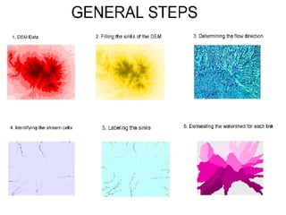

The document outlines the process of delineating a watershed area and identifying river streams using spatial and 3D analysis in Malang, East Java, Indonesia. It describes the data used, including SRTM digital elevation model (DEM) data, and the general methodology for determining watersheds through flow direction, flow accumulation, and identification of stream cells. The steps include sink filling, determining watershed links, and calculating drainage areas associated with each link.


