BIM/GIS Integration: A Practical Approach in Real CasesSANGHEE SHIN
This talk was given at the OGC 3DIM DWG meeting in Orleans, France. I've tried to talk more about technical aspects behind mago3D and F4D format. Also I shared my experiences on integration of BIM and 3D GIS in a single web platform in real cases.
State of mago3D, An Open Source Based Digital Twin PlatformSANGHEE SHIN
I gave this talk at the FOSS4G Buenos Aires 2021.
mago3D(https://github.com/Gaia3D/mago3djs) is a relatively new project first released in July 2017. The ultimate goal of mago3D project is developing an open source based digital twin platform that can replicate and simulate the real world objects, processes, and phenomena on web environment. mago3D is on its way to achieve this goal now. As a Digital Twin platform, it can integrate, manage, and visualize various kinds of data formats such as CityGML, IndoorGML, LAS, IFC, 3DS, and other popular GIS formats. It utilizes many open source projects as a baseline framework. mago3D has been used in various industry sectors including ship building, urban design & management, indoor data management, and national defense. In this talk, I showcased several real projects that employed the mago3D and shared recent improvements and new features of mago3D.
State of mago3D, An Open Source Based Digital Twin PlatformSANGHEE SHIN
I gave this talk at the FOSS4G Thailand 2019 which was held at Chulalongkorn University, Bangkok on 4th Nov 2019. I talked about the recent achievements and improvements of mago3D project, an open source based Digital Twin platform. mago3D(http mago3d.com) is relatively new project first released in July 2017. The ultimate goal of mago3D is developing an open source based digital twin platform that can replicate and simulate the real world objects, processes, and phenomena on web environment. mago3D has been used in various industry sectors including ship building, urban management, indoor data management, and national defense. In this talk I showcased several real projects that used the mago3D and shared what I learnt from these projects. Also I introduced new features and future plan of mago3D.
Let’s Power the Analytics and 3D to the Web Based Military Geo-Portal using F...SANGHEE SHIN
In this talk, I introduced the web based military geo-portal system which was implemented on top of numerous open source projects such as PostGIS, GeoServer, Cesium, mago3D, OpenGXT. This military geo-portal system provides integrated search, layer control, satellite image retrieval, spatial terrain analysis, reading coordinates, and map notes functionalities to the military officers through intranet. This system is basically a web based 3D GIS utilizing mago3D and can be switched to 2D. This system utilizes the OGC WPS Web Processing Service for the analysis on web environment. As a result of this system implementation, military officers can access the huge amount of geospatial data and analysis functions on a web environment without installing additional software.
Ivan Sahumbaiev "Deep Learning approaches meet 3D data"Fwdays
During this talk, I’d be talking about how 3d data can be processed with Deep Learning models. The main focus would be on Point Clouds.
Session agenda:
What are 3D data and its representation
Overview of libraries to visualize and process
How to collect. Cameras. Calibration
The current state of the art for point cloud processing with Deep Learning models.
classification problem. Models to use
segmentation problem. Models to use
datasets. Losses and training routine
Point clouds correspondences
spectral methods to generate correspondences
Limitations.
Current State of mago3D, an Open Source Based Digital Twin PlatformSANGHEE SHIN
I gave this talk at the FOSS4G 2019 Bucharest. I talked about the recent achievements and improvements of mago3D project, an open source based Digital Twin platform. mago3D(http mago3d.com) is relatively new project first released in July 2017. The ultimate goal of mago3D is developing an open source based digital twin platform that can replicate and simulate the real world objects, processes, and phenomena on web environment. mago3D is on its way to achieve this goal now. mago3D has been used in various industry sectors including ship building, urban management, indoor data management, and national defense. In this talk I showcased several real projects that employed the mago3D and shared what I learnt from these projects.
Introduction to mago3D: A web based GeoBIM platform on top of FOSS4GSANGHEE SHIN
I introduced mago3D at the FOSS4G(Free & Open Source SW for Geospatial) 2018 Dar es Salaam. mago3D is an open source based web GeoBIM platform that can manage/display large/complex 3D objects from BIM/AEC on top of 3D DIS platform. This slides contains recent trends of GeoBIM, mago3D components, several key algorithms applied to mago3D, future plan, and several real cases.
Introduction to mago3D, an Open Source Based Digital Twin PlatformSANGHEE SHIN
This talk was given at the Busan Eco Delta City(Korea National Pilot Smart City) technical workshop held on 18th July. I talked about introduction and history of mago3D, some core technologies, real cases, and lessons learnt in this workshop.
mago3D: Let's integrate BIM and 3D GIS on top of FOSS4GSANGHEE SHIN
This presentation was given at FOSS4G Europe 2017 which was held at ENSG, France.
***
Let's integrate BIM and 3D GIS on top of FOSS4G!
Sanghee Shin, Sungdo Son, BJ Jang, JeongDae Cheon, Hakjoon Kim
Although there has been numerous attempts to integrate indoor and outdoor space on a single geospatial platform, the outcome of these attempts are not so satisfactory till to date. Difference of data model, massive number of data to be rendered, big volume of file size are among those major technical barriers that hindered seamless integration of indoor and outdoor space. This talk will introduce a brand-new FOSS4G project called Mago3D that could seamlessly integrate BIM(Building Information Model) and popular 3D GIS model in web browser using Cesium or Web World Wind. Mago3D project aims at developing a JavaScript plug-in for existing WebGL Globe to expand WebGL Globe's functionality and usability even to indoor space and architectural(BIM) areas. To do this, Mago3D.js has been designed and developed as a WebGL independent JavaScript. Mago3D.js is composed of 6 main components like follows:
Mago3D Connector that interacts with WebGL Globe such as Cesium
Mago3D Renderer that shades and renders 3D data
Mago3D Accelerator that carries out performance enhancing algorithms such frustum & occlusion culling, indexing, LOD(Level Of Detail) handing
Mago3D Data Container that contains and manages 3D data
Mago3D Process Manager that manages whole process from data receiving to rendering
Mago3D REST API that provides API for 3D data sending and receiving
By plug in Mago3D.js to Cesium, Web World Wind, users can expand those WebGL functionality and usability to indoor space. One of big hurdle to integrate indoor and outdoor space simultaneously is handling and visualisation of massive 3D data. To overcome this hurdle, new format called F4D has been devised adopting block reference concept. Also a format converter that converts popular 3D format to F4D has been developed. Currently industry standard IFC(Industry Foundation Classes), JT(Jupiter Tessellation), and popular 3D formats such as OBJ, 3DS, COLLADA DAE can be converted to F4D format. F4D format coupled with Mago3D.js has proven that it can increase memory management efficiency and rendering speed drastically. MAGO3D can now visualise massive 3D data including indoor objects, at least 100k objects, in a single scene seamlessly with traditional outdoor 3D GIS objects. Users can now manage and handle almost every geospatial object from bolt & nut level to whole globe level with MAGO3D. This project will evolve to manage and service more dynamic data such as IoT (Internet of Things), point clouds, climate & weather data, and transportation..
This talk was given by Yeonhwa Jeong at the FOSS4G 2019 Bucharest. She introduced how to display sea surface wind data, e.g. ASCAT, WindSAT, SCATSAT of 12.5km or 25km resolution, using Mapbox vector tile specification.
How to Create GIS and BIM InteroperabilitySafe Software
Discover how to solve the most common problems with BIM and GIS integration. See how to easily move data between IFC, Autodesk Revit, SketchUp 2015, Esri ArcGIS, AutoCAD, and more. You'll also learn how to use automated techniques to get simplified BIM geometries into GIS, combine attribute or tabular data with existing models, perform space extraction, QC data, and much more.
One of goal of this project is seamless integration of indoor and outdoor space on top of web browser. This project aims at developing a sort of plugin for WebGL glove(Web World Wind, Cesium) to expand its functionalities and usabilities to indoor space and architectural (BIM) areas. MAGO3D can import IFC (Industry Foundation Classes) data from architecture files. And then MAGO3D can visualise massive indoor data, at least 100k objects, in a single scene seamlessly with traditional outdoor 3D GIS objects. Users can now manage and handle almost every geospatial object from desktop level to space level with MAGO3D. This project will evolve to manage and service more dynamic data such as IoT (Internet of Things), climate and weather data, and transportation.
Improving access to satellite imagery with Cloud computingRAHUL BHOJWANI
The aim of this presentation is to introduce cloud computing platforms that have now made it possible for us to have access to a wide variety of Satellite Imagery data along with the computing power required to run sophisticated Machine Learning models on that. Also, it briefly explains one available dataset and what problems are currently being tackled with that, to motivate the use of geospatial datasets in solving real-life problems.
PS:- It is our* class presentation given for a course taken under Prof Shashi Shekhar at the University of Minnesota.
* - Rahul Bhojwani(rahulbhojwani2003@gmail.com) and Kate Kuehl(katekuehl@gmail.com)
Mago3D - An innovative AEC/GIS integration platform that can service millions...SANGHEE SHIN
This talk was given at the Geospatial World Forum 2018.
This slides introduce a brand new live 3D geo-platform called mago3D that can integrate BIM/AEC(Architecture, Engineering, Construction) and 3D GIS in a web browser. mago3D can manage and visualize millions of 3D objects from different sources in a web browser without installing any plugin or ActiveX. 2 main cores of mago3D are mago3D.js and F4D format. mago3D.js is a set of JavaScript that expands existing WebGL Globe's functionality and usability. mago3D.js increases rendering quality and speed. mago3D.js runs on top of AGI's Cesium.js and NASA Web World Wind at the moment. One of big hurdle to integrate AEC and 3D GIS simultaneously is handling and visualizing the massive 3D objects. To overcome this hurdle, new format called F4D has been devised. F4D is a sort of 3D service format that contains LOD, pre-processed occlusion culling information, and visibility indexes. Currently industry standard IFC(Industry Foundation Classes), JT(Jupiter Tessellation), and popular 3D formats such as OBJ, 3DS, COLLADA DAE can be converted to F4D format. mago3D has been successfully used in several industries including ship building, FM(Facility Management), constructions so far. Real success story of mago3D will be presented during the talk.
This is the technical workshop material for mago3D, a web based open source GeoBIM platform. This material provides step-by-step hands-on guide including component installing, data converting, and data publishing. 4 hours are expected to complete this course.
mago3D, a web based BIM/GIS integration platform on top of open sourceSANGHEE SHIN
This presentation was given at the Geo|Design+BIM conference which was held at Amsterdam in November 2017. This presentation introduces the open source project mago3D that can integrate BIM and 3D GIS in a web browser.
We envision a society where people are beautiful inside & out, supporting each other in improving the quality of life through entrepreneurship.
Age Concepts is a network marketing company that has high regard on Ethical Business Practice, committed in providing access to valuable products and great income opportunities while promoting social responsibilities.
COMIT March 2017 - Cost Effective Digitisation of Existing AssetsComit Projects Ltd
Presentation by Graham Cameron of GSK on cost effective digitisation of existing assets. Presented at the COMIT community day held at Bentley in London, 2nd March 2017
Point Cloud to BIM Services | Silicon Engineering Consultants New Zealand .pptxSiliconecnewzealand
Plunge into the depths of Point Cloud to BIM Services, where laser-sharp 3D scanning transforms workflows. Journey through its role in elevating accuracy, efficiency, and project excellence.
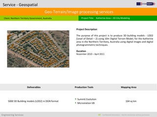
1. Engineering Services Confidential Information – Not for distribution without permission62
Geo-Terrain/Image processing services
Client: Northern Territory Government, Australia
Service - Geospatial
Project Title: Katherine Area – 3D City Modeling
Project Description
The purpose of this project is to produce 3D building models - LOD2
(Level of Detail – 2) using 10m Digital Terrain Model, for the Katherine
area in the Northern Territory, Australia using digital images and digital
photogrammetric techniques.
Duration
November 2010 – April 2011
Deliverables Production Tools Mapping Area
5000 3D Building models (LOD2) in DGN format
Summit Evolution
Microstation V8
164 sq km
2. Engineering Services Confidential Information – Not for distribution without permission63
Geo-Terrain/Image processing services
Client: Groupe SCE, India
Service - Geospatial
Project Title: Regensburg 3D City Modelling
Project Description
The purpose of this project is create 3D city models with roof tops and
texturing of facades through stereoscopic techniques for an area of 5 sq
km. The model shows all features on buildings and roofs like bay
windows, chimneys, etc. which contained very high level of detail. In
this project a total of approximately 2000 buildings were modeled.
Duration
December 2009
Deliverables Production Tools Mapping Area
3D Building Model LOD03 as ESRI Shape file
3D Building Model LOD03 as Google sketchUp file
Summit Evolution
Microstation V8
Google SketchUp
5 sq km
3. Engineering Services Confidential Information – Not for distribution without permission64
Geo-Terrain/Image processing services
Client: Infoterra, United Kingdom
Service - Geospatial
Project Title: Infoterra – 3D Building Modeling Project
Project Description
The purpose of this pilot was to produce 3D Building model (LOD3) and
5m digital terrain model for a given area using in digital
photogrammetric techniques.
Duration
November 2010
Deliverables Production Tools Mapping Area
3D Building Model LOD03 as ESRI Shape file
5m digital elevation model
Summit Evolution
Microstation V8
10 sq km