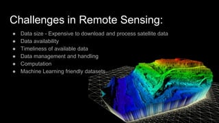
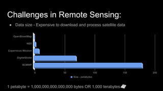
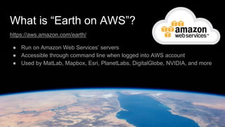
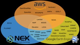
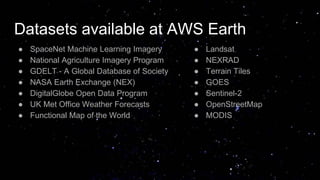
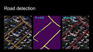
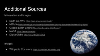
University of Minnesota-Twin Cities
Rahul Bhojwani(bhojw005@umn.edu)
Kate Kuehl(kuehl088@umn.edu)
Improving Access to Satellite Imagery
with Cloud Computing
Challenges in Remote Sensing:
● Data size - Expensive to download and process satellite data
● Data availability
● Timeliness of available data
● Data management and handling
● Computation
● Machine Learning friendly datasets
Challenges in Remote Sensing:
● Data size - Expensive to download and process satellite data
1 petabyte = 1,000,000,000,000,000 bytes OR 1,000 terabytes
What is “Earth on AWS”?
https://aws.amazon.com/earth/
● Run on Amazon Web Services’ servers
● Accessible through command line when logged into AWS account
● Used by MatLab, Mapbox, Esri, PlanetLabs, DigitalGlobe, NVIDIA, and more
What is “Google Earth Engine”?
https://earthengine.google.com/
● We used this in class
● Used by WRI, FAO, U of M, and other non-profits/universities
● Free for research, education, and nonprofit use
Python and JavaScript API’s available here: https://developers.google.com/earth-
engine/#api
What is “NEX”?
https://nex.nasa.gov/nex/
NASA Earth Exchange
● Accessible only by NASA supported researchers
● Runs on a private cloud at NASA Ames Research Center
Landsat
MODISNAIP
OpenStreetMap
Sentinel-1
Sentinel-2
Elevation
GDELT
NOAA
SpaceNet IARPA
MOGREPS
LOCA
GlobCover
SRTMPRISM
BCCA
NARR
FLUXNET
FIA
AVHRR
GIMM
TRIMM
WorldPop
Oxford MAP
NASS WWF
PSDI
GSMaP
CHIRPS
NCEP/NCAR
WorldClim
WHRC
Geoscience Australia
Datasets available at AWS Earth
● SpaceNet Machine Learning Imagery
● National Agriculture Imagery Program
● GDELT - A Global Database of Society
● NASA Earth Exchange (NEX)
● DigitalGlobe Open Data Program
● UK Met Office Weather Forecasts
● Functional Map of the World
● Landsat
● NEXRAD
● Terrain Tiles
● GOES
● Sentinel-2
● OpenStreetMap
● MODIS
SpaceNet Machine Learning Imagery
● Commercial satellite imagery and labeled training data
● Intended for advancing innovation in Computer Vision
● To extract geometric features from remote sensing data such as:
○ Roads
○ Building footprints
○ Points of interest
Current Available Areas:
● Rio De Janeiro
● Paris
● Las Vegas
● Shanghai
● Khartoum
Object Detection
Semantic segmentation
Source Image Inference visualization
Road detection
Quiz
What challenges of remote sensing that’s addressed by cloud geospatial data?
A. Petabyte size of datasets
B. Timeliness of available data
C. Data management and handling
D. Computation
E. Machine Learning friendly datasets
Additional Sources
Information and Images
● Earth on AWS https://aws.amazon.com/earth/
● NDIVIA https://devblogs.nvidia.com/parallelforall/exploring-spacenet-dataset-using-digits/
● Google Earth Engine https://earthengine.google.com/
● NASA https://www.nasa.gov
● DigitalGlobe http://ow.ly/rIhV307X3u6
Images
● Wikipedia Commons https://commons.wikimedia.org/

Improving access to satellite imagery with Cloud computing

  • 1.
    University of Minnesota-TwinCities Rahul Bhojwani(bhojw005@umn.edu) Kate Kuehl(kuehl088@umn.edu) Improving Access to Satellite Imagery with Cloud Computing
  • 2.
    Challenges in RemoteSensing: ● Data size - Expensive to download and process satellite data ● Data availability ● Timeliness of available data ● Data management and handling ● Computation ● Machine Learning friendly datasets
  • 3.
    Challenges in RemoteSensing: ● Data size - Expensive to download and process satellite data 1 petabyte = 1,000,000,000,000,000 bytes OR 1,000 terabytes
  • 4.
    What is “Earthon AWS”? https://aws.amazon.com/earth/ ● Run on Amazon Web Services’ servers ● Accessible through command line when logged into AWS account ● Used by MatLab, Mapbox, Esri, PlanetLabs, DigitalGlobe, NVIDIA, and more
  • 5.
    What is “GoogleEarth Engine”? https://earthengine.google.com/ ● We used this in class ● Used by WRI, FAO, U of M, and other non-profits/universities ● Free for research, education, and nonprofit use Python and JavaScript API’s available here: https://developers.google.com/earth- engine/#api
  • 6.
    What is “NEX”? https://nex.nasa.gov/nex/ NASAEarth Exchange ● Accessible only by NASA supported researchers ● Runs on a private cloud at NASA Ames Research Center
  • 7.
  • 8.
    Datasets available atAWS Earth ● SpaceNet Machine Learning Imagery ● National Agriculture Imagery Program ● GDELT - A Global Database of Society ● NASA Earth Exchange (NEX) ● DigitalGlobe Open Data Program ● UK Met Office Weather Forecasts ● Functional Map of the World ● Landsat ● NEXRAD ● Terrain Tiles ● GOES ● Sentinel-2 ● OpenStreetMap ● MODIS
  • 9.
    SpaceNet Machine LearningImagery ● Commercial satellite imagery and labeled training data ● Intended for advancing innovation in Computer Vision ● To extract geometric features from remote sensing data such as: ○ Roads ○ Building footprints ○ Points of interest
  • 10.
    Current Available Areas: ●Rio De Janeiro ● Paris ● Las Vegas ● Shanghai ● Khartoum
  • 11.
  • 12.
    Semantic segmentation Source ImageInference visualization
  • 13.
  • 14.
    Quiz What challenges ofremote sensing that’s addressed by cloud geospatial data? A. Petabyte size of datasets B. Timeliness of available data C. Data management and handling D. Computation E. Machine Learning friendly datasets
  • 15.
    Additional Sources Information andImages ● Earth on AWS https://aws.amazon.com/earth/ ● NDIVIA https://devblogs.nvidia.com/parallelforall/exploring-spacenet-dataset-using-digits/ ● Google Earth Engine https://earthengine.google.com/ ● NASA https://www.nasa.gov ● DigitalGlobe http://ow.ly/rIhV307X3u6 Images ● Wikipedia Commons https://commons.wikimedia.org/

Editor's Notes

  • #4 “Big Geospatial Data – an OGC White Paper” Open Geospatial Consortium September 25, 2017
  • #5 Ask the class if anyone has heard of it It has existed in some form or another for 2 years
  • #6 Ask the class if anyone has heard of it
  • #7 Ask the class if anyone has heard of it
  • #12 https://devblogs.nvidia.com/parallelforall/exploring-spacenet-dataset-using-digits/
  • #14 https://medium.com/the-downlinq/spacenet-road-detection-and-routing-challenge-part-i-d4f59d55bfce