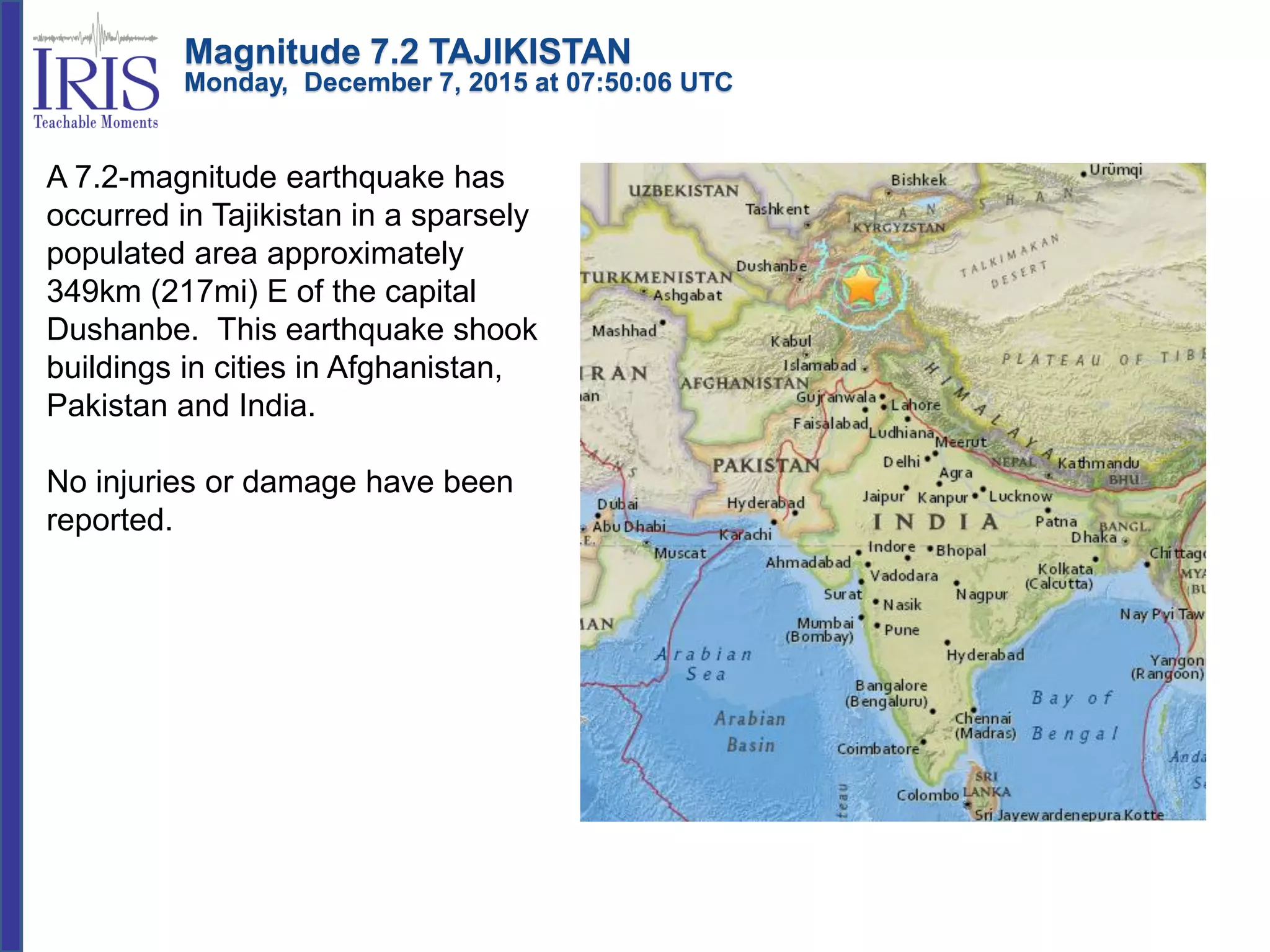
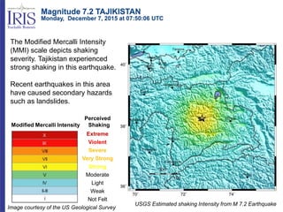
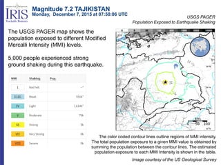
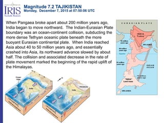
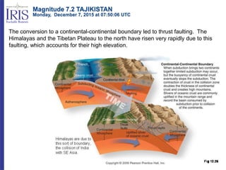
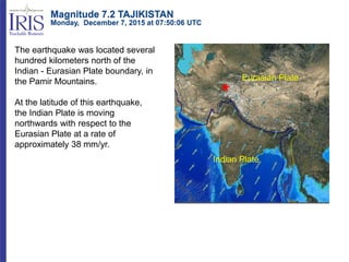
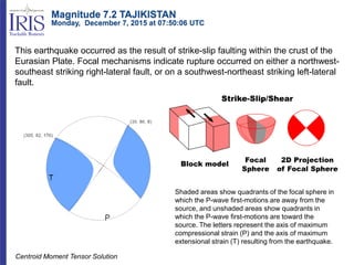
Magnitude 7.2 TAJIKISTAN
Monday, December 7, 2015 at 07:50:06 UTC
A 7.2-magnitude earthquake has
occurred in Tajikistan in a sparsely
populated area approximately
349km (217mi) E of the capital
Dushanbe. This earthquake shook
buildings in cities in Afghanistan,
Pakistan and India.
No injuries or damage have been
reported.
Modified Mercalli Intensity
Perceived
Shaking
Extreme
Violent
Severe
Very Strong
Strong
Moderate
Light
Weak
Not Felt
USGS Estimated shaking Intensity from M 7.2 Earthquake
The Modified Mercalli Intensity
(MMI) scale depicts shaking
severity. Tajikistan experienced
strong shaking in this earthquake.
Recent earthquakes in this area
have caused secondary hazards
such as landslides.
Image courtesy of the US Geological Survey
Magnitude 7.2 TAJIKISTAN
Monday, December 7, 2015 at 07:50:06 UTC
USGS PAGER
Population Exposed to Earthquake Shaking
Image courtesy of the US Geological Survey
The color coded contour lines outline regions of MMI intensity.
The total population exposure to a given MMI value is obtained by
summing the population between the contour lines. The estimated
population exposure to each MMI Intensity is shown in the table.
The USGS PAGER map shows the
population exposed to different Modified
Mercalli Intensity (MMI) levels.
5,000 people experienced strong
ground shaking during this earthquake.
Magnitude 7.2 TAJIKISTAN
Monday, December 7, 2015 at 07:50:06 UTC
When Pangaea broke apart about 200 million years ago,
India began to move northward. The Indian-Eurasian Plate
boundary was an ocean-continent collision, subducting the
more dense Tethyan oceanic plate beneath the more
buoyant Eurasian continental plate. When India reached
Asia about 40 to 50 million years ago, and essentially
crashed into Asia, its northward advance slowed by about
half. The collision and associated decrease in the rate of
plate movement marked the beginning of the rapid uplift of
the Himalayas.
Magnitude 7.2 TAJIKISTAN
Monday, December 7, 2015 at 07:50:06 UTC
The conversion to a continental-continental boundary led to thrust faulting. The
Himalayas and the Tibetan Plateau to the north have risen very rapidly due to this
faulting, which accounts for their high elevation.
Magnitude 7.2 TAJIKISTAN
Monday, December 7, 2015 at 07:50:06 UTC
The earthquake was located several
hundred kilometers north of the
Indian - Eurasian Plate boundary, in
the Pamir Mountains.
At the latitude of this earthquake,
the Indian Plate is moving
northwards with respect to the
Eurasian Plate at a rate of
approximately 38 mm/yr.
Magnitude 7.2 TAJIKISTAN
Monday, December 7, 2015 at 07:50:06 UTC
Indian Plate
Eurasian Plate
This earthquake occurred as the result of strike-slip faulting within the crust of the
Eurasian Plate. Focal mechanisms indicate rupture occurred on either a northwest-
southeast striking right-lateral fault, or on a southwest-northeast striking left-lateral
fault.
Shaded areas show quadrants of the focal sphere in
which the P-wave first-motions are away from the
source, and unshaded areas show quadrants in
which the P-wave first-motions are toward the
source. The letters represent the axis of maximum
compressional strain (P) and the axis of maximum
extensional strain (T) resulting from the earthquake.
Centroid Moment Tensor Solution
Magnitude 7.2 TAJIKISTAN
Monday, December 7, 2015 at 07:50:06 UTC
The P and S waves that traveled through the interior of the
Earth from the earthquake to Portland are difficult to identify on
this seismogram. Winter storms with strong winds are causing
large ocean waves in the Northeastern Pacific Ocean. These
ocean waves oscillate the solid Earth to produce “microseismic
noise” that overlaps in frequency with P and S seismic waves
The record of the earthquake on the University of Portland seismometer (UPOR) is
illustrated below. Portland is 10,547 km (6,553 miles, 95.0°) from the location of
this earthquake.
Surface waves traveled the 10,547 km from the
earthquake to Portland along the perimeter of the
Earth. Despite the distance and the microseismic
noise, the Rayleigh and Love surface waves are
easily visible on this seismogram.
Magnitude 7.2 TAJIKISTAN
Monday, December 7, 2015 at 07:50:06 UTC
Teachable Moments are a service of
IRIS Education & Public Outreach
and
The University of Portland
Magnitude 7.2 TAJIKISTAN
Monday, December 7, 2015 at 07:50:06 UTC

151207 tajikistan

  • 1.
    Magnitude 7.2 TAJIKISTAN Monday,December 7, 2015 at 07:50:06 UTC A 7.2-magnitude earthquake has occurred in Tajikistan in a sparsely populated area approximately 349km (217mi) E of the capital Dushanbe. This earthquake shook buildings in cities in Afghanistan, Pakistan and India. No injuries or damage have been reported.
  • 2.
    Modified Mercalli Intensity Perceived Shaking Extreme Violent Severe VeryStrong Strong Moderate Light Weak Not Felt USGS Estimated shaking Intensity from M 7.2 Earthquake The Modified Mercalli Intensity (MMI) scale depicts shaking severity. Tajikistan experienced strong shaking in this earthquake. Recent earthquakes in this area have caused secondary hazards such as landslides. Image courtesy of the US Geological Survey Magnitude 7.2 TAJIKISTAN Monday, December 7, 2015 at 07:50:06 UTC
  • 3.
    USGS PAGER Population Exposedto Earthquake Shaking Image courtesy of the US Geological Survey The color coded contour lines outline regions of MMI intensity. The total population exposure to a given MMI value is obtained by summing the population between the contour lines. The estimated population exposure to each MMI Intensity is shown in the table. The USGS PAGER map shows the population exposed to different Modified Mercalli Intensity (MMI) levels. 5,000 people experienced strong ground shaking during this earthquake. Magnitude 7.2 TAJIKISTAN Monday, December 7, 2015 at 07:50:06 UTC
  • 4.
    When Pangaea brokeapart about 200 million years ago, India began to move northward. The Indian-Eurasian Plate boundary was an ocean-continent collision, subducting the more dense Tethyan oceanic plate beneath the more buoyant Eurasian continental plate. When India reached Asia about 40 to 50 million years ago, and essentially crashed into Asia, its northward advance slowed by about half. The collision and associated decrease in the rate of plate movement marked the beginning of the rapid uplift of the Himalayas. Magnitude 7.2 TAJIKISTAN Monday, December 7, 2015 at 07:50:06 UTC
  • 5.
    The conversion toa continental-continental boundary led to thrust faulting. The Himalayas and the Tibetan Plateau to the north have risen very rapidly due to this faulting, which accounts for their high elevation. Magnitude 7.2 TAJIKISTAN Monday, December 7, 2015 at 07:50:06 UTC
  • 6.
    The earthquake waslocated several hundred kilometers north of the Indian - Eurasian Plate boundary, in the Pamir Mountains. At the latitude of this earthquake, the Indian Plate is moving northwards with respect to the Eurasian Plate at a rate of approximately 38 mm/yr. Magnitude 7.2 TAJIKISTAN Monday, December 7, 2015 at 07:50:06 UTC Indian Plate Eurasian Plate
  • 7.
    This earthquake occurredas the result of strike-slip faulting within the crust of the Eurasian Plate. Focal mechanisms indicate rupture occurred on either a northwest- southeast striking right-lateral fault, or on a southwest-northeast striking left-lateral fault. Shaded areas show quadrants of the focal sphere in which the P-wave first-motions are away from the source, and unshaded areas show quadrants in which the P-wave first-motions are toward the source. The letters represent the axis of maximum compressional strain (P) and the axis of maximum extensional strain (T) resulting from the earthquake. Centroid Moment Tensor Solution Magnitude 7.2 TAJIKISTAN Monday, December 7, 2015 at 07:50:06 UTC
  • 8.
    The P andS waves that traveled through the interior of the Earth from the earthquake to Portland are difficult to identify on this seismogram. Winter storms with strong winds are causing large ocean waves in the Northeastern Pacific Ocean. These ocean waves oscillate the solid Earth to produce “microseismic noise” that overlaps in frequency with P and S seismic waves The record of the earthquake on the University of Portland seismometer (UPOR) is illustrated below. Portland is 10,547 km (6,553 miles, 95.0°) from the location of this earthquake. Surface waves traveled the 10,547 km from the earthquake to Portland along the perimeter of the Earth. Despite the distance and the microseismic noise, the Rayleigh and Love surface waves are easily visible on this seismogram. Magnitude 7.2 TAJIKISTAN Monday, December 7, 2015 at 07:50:06 UTC
  • 9.
    Teachable Moments area service of IRIS Education & Public Outreach and The University of Portland Magnitude 7.2 TAJIKISTAN Monday, December 7, 2015 at 07:50:06 UTC