Downloaded 30 times

![Show the LOC_ID Points via ST_Geometry
SELECT MAP_PAR_ID, LOC_ID,
CAST('POINT (' + CAST(CAST(substring(LOC_ID,3,6) as int) AS varchar) + ' ' +
CAST(CAST(substring(LOC_ID,10,7) as int) AS varchar) + ')' AS geometry) AS SHAPE,
'POINT (' + CAST(CAST(substring(LOC_ID,3,6) as int) AS varchar) + ' ' +
CAST(CAST(substring(LOC_ID,10,7) as int) AS varchar) + ')' as [ReadTheGeometry],
FROM <MyParcelFeatureClass>
X Y](https://image.slidesharecdn.com/45v40jxhs8qhgdqbphey-140515105732-phpapp02/85/Making-Use-of-Query-Layers-Spatial-Views-7-320.jpg)
![Show the LOC_ID Points via ST_Geometry
SELECT MAP_PAR_ID, LOC_ID,
CAST('POINT (' + CAST(CAST(substring(LOC_ID,3,6) as int) AS varchar) + ' ' +
CAST(CAST(substring(LOC_ID,10,7) as int) AS varchar) + ')' AS geometry) AS SHAPE,
'POINT (' + CAST(CAST(substring(LOC_ID,3,6) as int) AS varchar) + ' ' +
CAST(CAST(substring(LOC_ID,10,7) as int) AS varchar) + ')' as [ReadTheGeometry],
FROM <MyParcelFeatureClass>
X Y](https://image.slidesharecdn.com/45v40jxhs8qhgdqbphey-140515105732-phpapp02/85/Making-Use-of-Query-Layers-Spatial-Views-8-320.jpg)

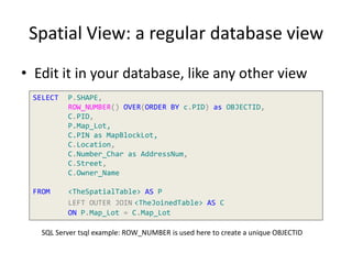
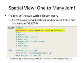


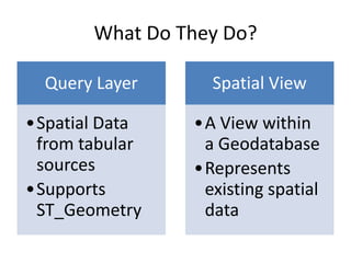
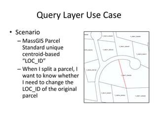
The document provides an overview of query layers and spatial views in ArcGIS, explaining their purpose and how to create them using SQL queries. It highlights practical use cases such as managing unique identifiers for parcels through centroid-based coordinates and the advantages of spatial views over traditional joins. The presentation also mentions technical requirements and offers examples of SQL commands for setting up query layers and spatial views.